“100 IMPORTANT ITEMS” - Kunstantikvariat Pama AS
“100 IMPORTANT ITEMS” - Kunstantikvariat Pama AS
“100 IMPORTANT ITEMS” - Kunstantikvariat Pama AS

You also want an ePaper? Increase the reach of your titles
YUMPU automatically turns print PDFs into web optimized ePapers that Google loves.
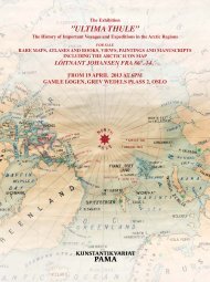
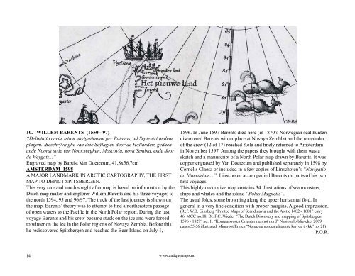
10. WILLEM BARENTS (1550 - 97)<br />
“Deliniatio cartæ trium navigationum per Batavos, ad Septentrionalem<br />
plagem...Beschrÿvinghe van drie Seÿlagien door de Hollanders gedaen<br />
ande Noordt syde van Noor:weghen, Moscovia, nova Sembla, ende door<br />
de Weygats...”<br />
Engraved map by Baptist Van Doetecum, 41,8x56,7cm<br />
AMSTERDAM 1598<br />
A MAJOR LANDMARK IN ARCTIC CARTOGRAPHY, THE FIRST<br />
MAP TO DEPICT SPITSBERGEN.<br />
This very rare and much sought after map is based on information by the<br />
Dutch map maker and explorer Willem Barents and his three voyages to<br />
the north 1594, 95 and 96/97. The track of the last journey is shown on<br />
the map. Barents’ theory was to attempt to find a northeastern passage<br />
of open waters to the Pacific in the North Polar region. During the last<br />
voyage Barents and his crew became stuck on the ice and were forced<br />
to winter on the ice in the Polar regions of Novaya Zembla. Before this<br />
he rediscovered Spitsbergen and reached the Bear Island on July 1,<br />
14<br />
www.antiquemaps.no<br />
1596. In June 1597 Barents died here (in 1870’s Norwegian seal hunters<br />
discovered Barents winter place at Novaya Zembla) and the remainder<br />
of the crew (12 of 17) reached Kola and finely returned to Amsterdam<br />
in November 1597. Among the papers they brought with them was a<br />
sketch and a manuscript of a North Polar map drawn by Barents. It was<br />
copper engraved by Van Doetecum and published separately in 1598 by<br />
Cornelis Claesz or included in a few copies of Linschoten’s “Navigatio<br />
ac Itinerarium...”. Linschoten accompanied Barents on parts of his two<br />
first voyages.<br />
This highly decorative map contains 34 illustrations of sea monsters,<br />
ships and whales and the island “Polus Magnetis”.<br />
The usual folds, some browning along the upper horizontal fold. In<br />
general in a very fine condition with proper margins. A good impression.<br />
(Ref: W.B. Ginsberg “Printed Maps of Scandinavia and the Arctic 1482 - 1601” entry<br />
46, MCC no.18, Dr. F.C. Wieder “The Dutch Discovery and mapping of Spitsbergen<br />
1596 - 1829“ no. 1, “Kompassrosen Orientering mot nord” Nasjonalbiblioteket 2009<br />
pages 55-56 illustrated, Mingroot/Ermen “Norge og norden på gamle kart og trykk” no. 21)<br />
P.O.R.