“100 IMPORTANT ITEMS” - Kunstantikvariat Pama AS
“100 IMPORTANT ITEMS” - Kunstantikvariat Pama AS
“100 IMPORTANT ITEMS” - Kunstantikvariat Pama AS

You also want an ePaper? Increase the reach of your titles
YUMPU automatically turns print PDFs into web optimized ePapers that Google loves.
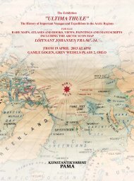
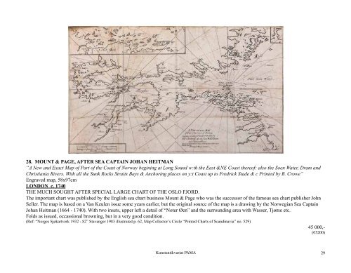
28. MOUNT & PAGE, AFTER SEA CAPTAIN JOHAN HEITMAN<br />
“A New and Exact Map of Part of the Coast of Norway begining at Long Sound w:th the East &NE Coast thereof: also the Soen Water, Dram and<br />
Christiania Rivers. With all the Sunk Rocks Straits Bays & Anchoring places on y:t Coast up to Fredrick Stade & c Printed by B. Crowe”<br />
Engraved map, 58x97cm<br />
LONDON c. 1740<br />
THE MUCH SOUGHT AFTER SPECIAL LARGE CHART OF THE OSLO FJORD.<br />
The important chart was published by the English sea chart business Mount & Page who was the successor of the famous sea chart publisher John<br />
Seller. The map is based on a Van Keulen issue some years earlier, but the original source of the map is a drawing by the Norwegian Sea Captain<br />
Johan Heitman (1664 - 1740). With two insets, upper left a detail of “Noter Øen” and the surrounding area with Wasser, Tjøme etc.<br />
Folds as issued, occassional browning, but in a very good condition.<br />
(Ref: “Norges Sjøkartverk 1932 - 82” Stavanger 1983 illustrated p. 62, Map Collector’s Circle “Printed Charts of Scandinavia” no. 529)<br />
45 000,-<br />
(€5200)<br />
<strong>Kunstantikvariat</strong> PAMA<br />
29