“100 IMPORTANT ITEMS” - Kunstantikvariat Pama AS
“100 IMPORTANT ITEMS” - Kunstantikvariat Pama AS
“100 IMPORTANT ITEMS” - Kunstantikvariat Pama AS

Create successful ePaper yourself
Turn your PDF publications into a flip-book with our unique Google optimized e-Paper software.
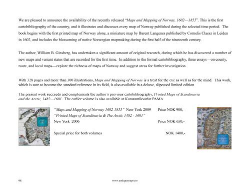
We are pleased to announce the availability of the recently released “Maps and Mapping of Norway, 1602—1855”. This is the first<br />
cartobibliography of the country, and it illustrates and discusses every map of Norway published during the selected time period. The<br />
book begins with the first printed map of Norway alone, a miniature map by Barent Langenes published by Cornelis Claesz in Leiden<br />
in 1602, and includes the blossoming of native Norwegian mapmaking during the first half of the nineteenth century.<br />
The author, William B. Ginsberg, has undertaken a significant amount of original research, during which he has discovered a number of<br />
new maps and variant states that are recorded for the first time. In addition to the formal cartobibliography, three essays—on county,<br />
route, and local maps—explore the richness of maps of Norway and suggest areas for further investigation.<br />
With 328 pages and more than 300 illustrations, Maps and Mapping of Norway is a treat for the eye as well as for the mind. This work,<br />
which is sure to become the standard reference in its field, is also available in a deluxe, slipcased limited edition.<br />
The present work succeeds and complements the author’s previous cartobibliography, Printed Maps of Scandinavia<br />
and the Arctic, 1482—1601. The earlier volume is also available at <strong>Kunstantikvariat</strong> PAMA.<br />
98<br />
”Maps and Mapping of Norway 1602-1855” New York 2009 Price NOK 900,-<br />
”Printed Maps of Scandinavia & The Arctic 1482 - 1601”<br />
New York 2006 Price NOK 650,-<br />
Special price for both volumes NOK 1400,-<br />
www.antiquemaps.no