“100 IMPORTANT ITEMS” - Kunstantikvariat Pama AS
“100 IMPORTANT ITEMS” - Kunstantikvariat Pama AS
“100 IMPORTANT ITEMS” - Kunstantikvariat Pama AS

Create successful ePaper yourself
Turn your PDF publications into a flip-book with our unique Google optimized e-Paper software.
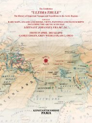
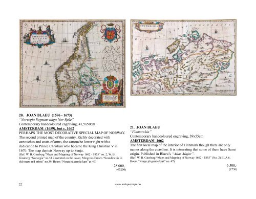
20. JOAN BLAEU (1596 - 1673)<br />
“Norvegia Regnum vulgo Nor-Ryke”<br />
Contemporary handcoloured engraving, 41,5x50cm<br />
AMSTERDAM (1659), but c. 1662<br />
PERHAPS THE MOST DECORATIVE SPECIAL MAP OF NORWAY.<br />
The second printed map of the country. Richly decorated with<br />
cartouches and coats of arms, the cartouche lower right with a<br />
dedication to Prince Christian who became the King Christian V in<br />
1670. The map depicts Norway up to Senja.<br />
(Ref: W. B. Ginsberg “Maps and Mapping of Norway 1602 - 1855” no. 2, W. B.<br />
Ginsberg “Norvegia” no.51 illustrated on the cover, Mingroot-Ermen “Scandinavia in<br />
old maps and prints” no.39, Hoem “Norge på gamle kart” p. 49)<br />
28 000,-<br />
(€3250)<br />
22<br />
www.antiquemaps.no<br />
21. JOAN BLAEU<br />
“Finmarchia”<br />
Contemporary handcoloured engraving, 39x55cm<br />
AMSTERDAM 1662<br />
The first local map of the interior of Finnmark though there are only<br />
names along the coastline. It is interesting that some of them have Sami<br />
origin. Published in Blaeu’s “Atlas Major”.<br />
(Ref: W. B. Ginsberg “Maps and Mapping of Norway 1602 - 1855” (No. 2) BLA 6,<br />
Hoem “Norge på gamle kart” no. 47)<br />
6 500,-<br />
(€750)