“100 IMPORTANT ITEMS” - Kunstantikvariat Pama AS
“100 IMPORTANT ITEMS” - Kunstantikvariat Pama AS
“100 IMPORTANT ITEMS” - Kunstantikvariat Pama AS

You also want an ePaper? Increase the reach of your titles
YUMPU automatically turns print PDFs into web optimized ePapers that Google loves.
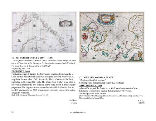
16. Sir, ROBERT DUDLEY (1574 - 1649)<br />
“Carta particolare che comincia con la Iutlandia è contiene parte della<br />
costa di Suetzia è della Noruegia La longitudine comincia da l’Isola di<br />
Picho di Asores. di Europa Carta XXXVIII”<br />
Engraving, 48x75cm<br />
FLORENCE 1646<br />
First edition map. It depicts the Norwegian coastline from Arendal to<br />
Oslo, further with Østfold and down along the Swedish west coast. A<br />
map from the sea atlas “Dell’ Arcano del Mare” (Secrets of the Sea)<br />
published in 1646 and 1661 only. The charts from Dudley’s sea atlas is<br />
noteworthy that for the first time sea charts were drawn in the Mercator<br />
projection. The engraver was Antonio Lucini and it is claimed that he<br />
used 12 years and over 2000 kilograms of copper to engrave the plates.<br />
Excellent condition.<br />
(Ref: W. B. Ginsberg “Norvegia Regnum” no. 82)<br />
20<br />
16 000,-<br />
(€1860)<br />
www.antiquemaps.no<br />
17. WILLIAM and JOAN BLAEU<br />
“Regiones Sub Polo Arctico”<br />
Contemporary handcoloured engraving, 41x53cm<br />
AMSTERDAM c. 1649<br />
A beautiful map of the Arctic area. With a dedication coat of arms<br />
belonging to Guillelmo Backer. Latin text and “4C” verso.<br />
A fine copy with fresh colours.<br />
(Ref: P. Burden “The Mapping of North America” no. 252 state 2 (of 2), Kershaw “The<br />
Mapping of Canada” entry 127a)<br />
9 000,-<br />
(€1045)