“100 IMPORTANT ITEMS” - Kunstantikvariat Pama AS
“100 IMPORTANT ITEMS” - Kunstantikvariat Pama AS
“100 IMPORTANT ITEMS” - Kunstantikvariat Pama AS

You also want an ePaper? Increase the reach of your titles
YUMPU automatically turns print PDFs into web optimized ePapers that Google loves.
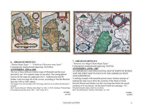
6. ABRAHAM ORTELIUS<br />
“Daniae Regni Typus” + “Cimbricae Chersonesi nunc Iutiæ”<br />
Contemporary handcoloured engraving, 34,5x49cm<br />
ANTWERPEN 1595 or 1601<br />
The last of three different Ortelius maps of Denmark and the most<br />
decorative one. Two separate maps on one sheet. The cartographical<br />
sources for the maps are supposed to be C. Anthoniszoon and M.<br />
Jordan. Latin text page 48 on the reverse, according to Van den Broecke<br />
from the 1595 or 1601 edition.<br />
The margin lower left and right with a browning, otherwise an excellent and decorative<br />
example.<br />
(Ref: Van den Broecke “Ortelius Atlas Maps” no. 86a + b, W.B. Ginsberg “Printed Maps<br />
of Scandinavia and the Arctic 1482 – 1601” Entry 24.7)<br />
10 000,-<br />
(€1160)<br />
<strong>Kunstantikvariat</strong> PAMA<br />
7. ABRAHAM ORTELIUS<br />
“Tartariae sive Magni Chami Regni Typus”<br />
Contemporary handcoloured engraving, 36x47cm<br />
ANTWERPEN (1570) - 1587<br />
AN <strong>IMPORTANT</strong> AND INFLUENTIAL MAP OF PARTS OF RUSSIA<br />
AND THE FIRST MAP TO FOCUS ON THE AMERICAN WEST<br />
AND NORTHWEST.<br />
A striking example with beautiful period colour. Ortelius attempt of<br />
making this map was to show the existence of the Strait of Anian<br />
between Russia and Alaska even this was long time before the actual<br />
existence of it was known. On the back French text and page “92“.<br />
Mounted along the edges, otherwise excellent.<br />
(Ref: Van den Broecke “Ortelius Atlas Maps” no. 163)<br />
18 000,-<br />
(€2090)<br />
11