“100 IMPORTANT ITEMS” - Kunstantikvariat Pama AS
“100 IMPORTANT ITEMS” - Kunstantikvariat Pama AS
“100 IMPORTANT ITEMS” - Kunstantikvariat Pama AS

You also want an ePaper? Increase the reach of your titles
YUMPU automatically turns print PDFs into web optimized ePapers that Google loves.
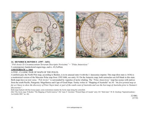
14. HENDRICK HONDIUS (1597 - 1651)<br />
“Poli Arctici Et Circumtacentium Terrarum Descriptio Novissima” + “Polus Antarcticus”<br />
2 contemporary handcolored engravings, each c. 43,5x49cm<br />
AMSTERDAM c. 1664<br />
A FINE , CL<strong>AS</strong>SIC PAIR OF MAPS OF THE POLES.<br />
A uniform pair, the North Pole map, according to Burden, is in its unusual state 4 with the J. Janssonius imprint. This map (first state is 1636) is<br />
a modernized version of the Mercator Polar map from 1595/1606, see entry 10. On the Antarctic map, both cartouches are left blank in this state.<br />
Both maps have no text verso. “Poli Arctici” is surrounded by vignettes of arctic whaling. The “Polus Antarcticus” map has scenes with natives<br />
from the south Pacific, Pategonia. Magellanica and Cape of Good Hope. Tooley writes in “Mapping of Australia” no.10: “the first printed map as<br />
far as I know to show the discovery of Peter Nuyts land, or part of the south coast of Australia and was the best map of Australia prior to Tasman’s<br />
discoveries”.<br />
Both maps backed with fine tisssue paper, some restorations (mainly the Arctic map) along the centrefold.<br />
(Ref: The Arctic map: P. Burden “The Mapping of North America” 246 “state 4”, Kershaw “Printed Maps of Canada” entry 101 “third state”, W. B. Ginsberg “Septentrionalium -<br />
An Exhibit 2001” no. 44)<br />
32 000,-<br />
(€3720)<br />
18<br />
www.antiquemaps.no