“100 IMPORTANT ITEMS” - Kunstantikvariat Pama AS
“100 IMPORTANT ITEMS” - Kunstantikvariat Pama AS
“100 IMPORTANT ITEMS” - Kunstantikvariat Pama AS

Create successful ePaper yourself
Turn your PDF publications into a flip-book with our unique Google optimized e-Paper software.
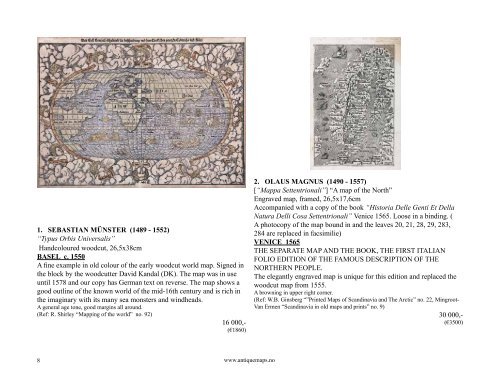
1. SEB<strong>AS</strong>TIAN MÜNSTER (1489 - 1552)<br />
“Typus Orbis Universalis”<br />
Handcoloured woodcut, 26,5x38cm<br />
B<strong>AS</strong>EL c. 1550<br />
A fine example in old colour of the early woodcut world map. Signed in<br />
the block by the woodcutter David Kandal (DK). The map was in use<br />
until 1578 and our copy has German text on reverse. The map shows a<br />
good outline of the known world of the mid-16th century and is rich in<br />
the imaginary with its many sea monsters and windheads.<br />
A general age tone, good margins all around.<br />
(Ref: R. Shirley “Mapping of the world” no. 92)<br />
16 000,-<br />
(€1860)<br />
8<br />
www.antiquemaps.no<br />
2. OLAUS MAGNUS (1490 - 1557)<br />
[“Mappa Settentrionali”] “A map of the North”<br />
Engraved map, framed, 26,5x17,6cm<br />
Accompanied with a copy of the book “Historia Delle Genti Et Della<br />
Natura Delli Cosa Settentrionali” Venice 1565. Loose in a binding. (<br />
A photocopy of the map bound in and the leaves 20, 21, 28, 29, 283,<br />
284 are replaced in facsimilie)<br />
VENICE 1565<br />
THE SEPARATE MAP AND THE BOOK, THE FIRST ITALIAN<br />
FOLIO EDITION OF THE FAMOUS DESCRIPTION OF THE<br />
NORTHERN PEOPLE.<br />
The elegantly engraved map is unique for this edition and replaced the<br />
woodcut map from 1555.<br />
A browning in upper right corner.<br />
(Ref: W.B. Ginsberg “”Printed Maps of Scandinavia and The Arctic” no. 22, Mingroot-<br />
Van Ermen “Scandinavia in old maps and prints” no. 9)<br />
30 000,-<br />
(€3500)