“100 IMPORTANT ITEMS” - Kunstantikvariat Pama AS
“100 IMPORTANT ITEMS” - Kunstantikvariat Pama AS
“100 IMPORTANT ITEMS” - Kunstantikvariat Pama AS

You also want an ePaper? Increase the reach of your titles
YUMPU automatically turns print PDFs into web optimized ePapers that Google loves.
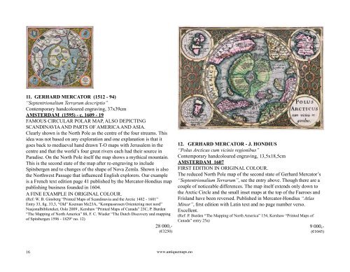
11. GERHARD MERCATOR (1512 - 94)<br />
“Septentrionalium Terrarum descriptio”<br />
Contemporary handcoloured engraving, 37x39cm<br />
AMSTERDAM (1595) - c. 1609 - 19<br />
FAMOUS CIRCULAR POLAR MAP, ALSO DEPICTING<br />
SCANDINAVIA AND PARTS OF AMERICA AND <strong>AS</strong>IA.<br />
Clearly shown is the North Pole as the centre of the four streams. This<br />
idea was not based on any exploration and one explanation is that it<br />
goes back to mediaeval hand drawn T-O maps with Jerusalem in the<br />
centre and that the world’s four great rivers each had their source in<br />
Paradise. On the North Pole itself the map shows a mythical mountain.<br />
This is the second state of the map after re-engraving to include<br />
Spitsbergen and to changes of the shape of Nova Zemla. Shown is also<br />
the Northwest Passage that influenced English explorers. Our example<br />
is a French text edition page 41 published by the Mercator-Hondius map<br />
publishing business founded in 1604.<br />
A FINE EXAMPLE IN ORIGINAL COLOUR.<br />
(Ref: W. B. Ginsberg “Printed Maps of Scandinavia and the Arctic 1482 - 1601”<br />
Entry 33, fig. 33,3, “Old” Koeman Me23A, “Kompassrosen Orientering mot nord”<br />
Nasjonalbiblioteket, Oslo 2009 , Kershaw “Printed Maps of Canada” 23C, P. Burden<br />
“The Mapping of North America” 88, F. C. Wieder “The Dutch Discovery and mapping<br />
of Spitsbergen 1596 - 1829“ no. 12)<br />
28 000,-<br />
(€3250)<br />
16<br />
www.antiquemaps.no<br />
12. GERHARD MERCATOR - J. HONDIUS<br />
“Polus Arcticus cum vicinis regionibus”<br />
Contemporary handcoloured engraving, 13,5x18,5cm<br />
AMSTERDAM 1607<br />
FIRST EDITION IN ORIGINAL COLOUR.<br />
The reduced North Pole map of the second state of Gerhard Mercator’s<br />
“Septentrionalium Terrarum”, see the entry above. Though there are a<br />
couple of noticeable differences. The map itself extends only down to<br />
the Arctic Circle and the small inset maps at the top of the Faeroes and<br />
Frisland have been reversed. Published in Mercator-Hondius “Atlas<br />
Minor”, first edition with Latin text and no page number verso.<br />
Excellent.<br />
(Ref: P. Burden “The Mapping of North America” 154, Kershaw “Printed Maps of<br />
Canada” entry 25a)<br />
9 000,-<br />
(€1045)