Data Specification on Atmospheric Conditions and ... - Inspire - Europa
Data Specification on Atmospheric Conditions and ... - Inspire - Europa
Data Specification on Atmospheric Conditions and ... - Inspire - Europa

Create successful ePaper yourself
Turn your PDF publications into a flip-book with our unique Google optimized e-Paper software.
INSPIRE Reference: D2.8.III.13-14_v3.0.0<br />
TWG-AC-MF <str<strong>on</strong>g>Data</str<strong>on</strong>g> <str<strong>on</strong>g>Specificati<strong>on</strong></str<strong>on</strong>g> <strong>on</strong> <strong>Atmospheric</strong> C<strong>on</strong>diti<strong>on</strong>s<br />
<strong>and</strong> Meteorological Geographical Features<br />
2012-07-05 Page 68<br />
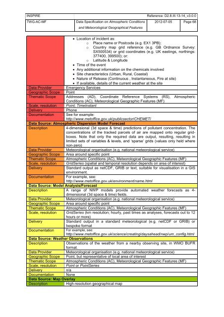
Locati<strong>on</strong> of incident as:<br />
o Place name or Postcode (e.g. EX1 3PB);<br />
o Country map grid reference (e.g. GB Ordnance Survey:<br />
SX500534) or grid coordinates (e.g. UK eastings, northings:<br />
377400, 399500); or:<br />
o Latitude & L<strong>on</strong>gitude<br />
Time of the event<br />
Any additi<strong>on</strong>al informati<strong>on</strong> <strong>on</strong> the chemicals involved<br />
Site characteristics (Urban, Rural, Coastal)<br />
Nature of Release (C<strong>on</strong>tinuous , Instantaneous, Fire at site)<br />
If available, details of the current weather at the site<br />
<str<strong>on</strong>g>Data</str<strong>on</strong>g> Provider Emergency Services<br />
Geographic Scope Point<br />
Thematic Scope Addresses (AD), Coordinate Reference Systems (RS), <strong>Atmospheric</strong><br />
C<strong>on</strong>diti<strong>on</strong>s (AC), Meteorological Geographic Features (MF)<br />
Scale, resoluti<strong>on</strong> Point; TimeInstant<br />
Delivery Ph<strong>on</strong>e<br />
Documentati<strong>on</strong> See for example:<br />
http://www.metoffice.gov.uk/publicsector/CHEMET/<br />
<str<strong>on</strong>g>Data</str<strong>on</strong>g> Source: <strong>Atmospheric</strong> Dispersi<strong>on</strong> Model Forecast<br />
Descripti<strong>on</strong> 4-dimensi<strong>on</strong>al (3d space & time) predicti<strong>on</strong>s of pollutant c<strong>on</strong>centrati<strong>on</strong>. The<br />
c<strong>on</strong>centrati<strong>on</strong>s of the tracked parcels of air are mapped <strong>on</strong>to regular gridboxes.<br />
Note that <strong>on</strong>ly the required data are output, resulting, resulting in<br />
limited sets of variables & levels, <strong>and</strong> ‗sparse‘ grids (values <strong>on</strong>ly held where<br />
n<strong>on</strong>-zero)<br />
<str<strong>on</strong>g>Data</str<strong>on</strong>g> Provider Meteorological organisati<strong>on</strong> (e.g. nati<strong>on</strong>al meteorological service)<br />
Geographic Scope Area around specific point<br />
Thematic Scope <strong>Atmospheric</strong> C<strong>on</strong>diti<strong>on</strong>s (AC), Meteorological Geographic Features (MF)<br />
Scale, resoluti<strong>on</strong> GridSeries (spatial <strong>and</strong> temporal resoluti<strong>on</strong> depends <strong>on</strong> area of interest)<br />
Delivery St<strong>and</strong>ard output as netCDF, GRIB or text, suitable for visualisati<strong>on</strong> in a GIS<br />
envir<strong>on</strong>ment.<br />
Documentati<strong>on</strong> For example, see:<br />
http://www.metoffice.gov.uk/envir<strong>on</strong>ment/name.html<br />
<str<strong>on</strong>g>Data</str<strong>on</strong>g> Source: Model Analysis/Forecast<br />
Descripti<strong>on</strong> A range of NWP models provide automated weather forecasts as 4dimensi<strong>on</strong>al<br />
(3d space & time) fields.<br />
<str<strong>on</strong>g>Data</str<strong>on</strong>g> Provider Meteorological organisati<strong>on</strong> (e.g. nati<strong>on</strong>al meteorological service)<br />
Geographic Scope Area around specific point<br />
Thematic Scope <strong>Atmospheric</strong> C<strong>on</strong>diti<strong>on</strong>s (AC), Meteorological Geographic Features (MF)<br />
Scale, resoluti<strong>on</strong> GridSeries (km resoluti<strong>on</strong>; hourly, past times as analyses, forecasts out to 12<br />
hours or more)<br />
Delivery St<strong>and</strong>ard output in a st<strong>and</strong>ard meteorological (e.g. netCDF or GRIB) or<br />
bespoke format<br />
Documentati<strong>on</strong> For example, see:<br />
http://www.metoffice.gov.uk/science/creating/daysahead/nwp/um_c<strong>on</strong>fig.html<br />
<str<strong>on</strong>g>Data</str<strong>on</strong>g> Source: Weather Observati<strong>on</strong>s<br />
Descripti<strong>on</strong> Observati<strong>on</strong>s of the weather from a nearby observing site, in WMO BUFR<br />
format.<br />
<str<strong>on</strong>g>Data</str<strong>on</strong>g> Provider Meteorological organisati<strong>on</strong> (e.g. nati<strong>on</strong>al meteorological service)<br />
Geographic Scope Point, but representative of local area of interest<br />
Thematic Scope <strong>Atmospheric</strong> C<strong>on</strong>diti<strong>on</strong>s (AC), Meteorological Geographic Features (MF)<br />
Scale, resoluti<strong>on</strong> Point or PointSeries<br />
Delivery n/a<br />
Documentati<strong>on</strong> N<strong>on</strong>e<br />
<str<strong>on</strong>g>Data</str<strong>on</strong>g> Source: Map Overlay<br />
Descripti<strong>on</strong> High-resoluti<strong>on</strong> geographical map