The freshwater macrophytes of - Fisheries Reports
The freshwater macrophytes of - Fisheries Reports
The freshwater macrophytes of - Fisheries Reports

You also want an ePaper? Increase the reach of your titles
YUMPU automatically turns print PDFs into web optimized ePapers that Google loves.
NSW Dept <strong>of</strong> Primary Industries 9<br />
• Flow type: If the watercourse was dry this feature was logged. <strong>The</strong> presence <strong>of</strong> pools, runs,<br />
riffles, rapids and waterfalls was logged.<br />
• Substrata type: Features such as bedrock, boulder, cobble and s<strong>of</strong>t sediment (gravel, sand or<br />
mud) were logged. <strong>The</strong> presence <strong>of</strong> concrete channels was logged.<br />
• Water clarity: <strong>The</strong> clarity <strong>of</strong> the water was logged (turbid, clear).<br />
2.4. Fieldwork: the data logging process<br />
As indicated previously, much <strong>of</strong> the land surrounding Lane Cove River and its tributaries and<br />
Middle Harbour Creek and its tributaries was inaccessible. It was therefore necessary to devise a<br />
procedure by which to assess common features in similar categories <strong>of</strong> tributaries, and record<br />
features <strong>of</strong> interest in individual tributaries. <strong>The</strong> field exercise had to be efficient but not overly<br />
consumptive <strong>of</strong> time and money.<br />
A real-time field mapping system was used to position the site and log its characteristics. Sites<br />
were chosen on the basis <strong>of</strong> accessibility along established tracks. Where the track paralleled the<br />
tributary, observations were made at intervals where either substrata, flow, water quality or<br />
<strong>macrophytes</strong> differed. A ‘site’ was defined as the immediate vicinity (2 – 3m) within which the<br />
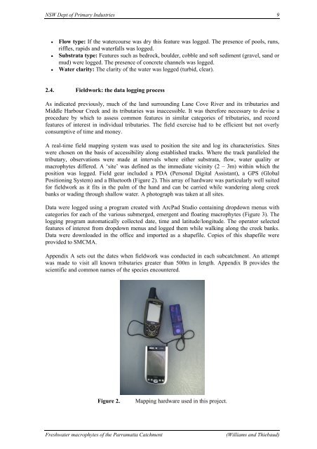
position was logged. Field gear included a PDA (Personal Digital Assistant), a GPS (Global<br />
Positioning System) and a Bluetooth (Figure 2). This array <strong>of</strong> hardware was particularly well suited<br />
for fieldwork as it fits in the palm <strong>of</strong> the hand and can be carried while wandering along creek<br />
banks or wading through shallow water. A photograph was taken at all sites.<br />
Data were logged using a program created with ArcPad Studio containing dropdown menus with<br />
categories for each <strong>of</strong> the various submerged, emergent and floating <strong>macrophytes</strong> (Figure 3). <strong>The</strong><br />
logging program automatically collected date, time and latitude/longitude. <strong>The</strong> operator selected<br />
features <strong>of</strong> interest from dropdown menus and logged them while walking along the creek banks.<br />
Data were downloaded in the <strong>of</strong>fice and imported as a shapefile. Copies <strong>of</strong> this shapefile were<br />
provided to SMCMA.<br />
Appendix A sets out the dates when fieldwork was conducted in each subcatchment. An attempt<br />
was made to visit all known tributaries greater than 500m in length. Appendix B provides the<br />
scientific and common names <strong>of</strong> the species encountered.<br />
Figure 2. Mapping hardware used in this project.<br />
Freshwater <strong>macrophytes</strong> <strong>of</strong> the Parramatta Catchment (Williams and Thiebaud)