The freshwater macrophytes of - Fisheries Reports
The freshwater macrophytes of - Fisheries Reports
The freshwater macrophytes of - Fisheries Reports

You also want an ePaper? Increase the reach of your titles
YUMPU automatically turns print PDFs into web optimized ePapers that Google loves.
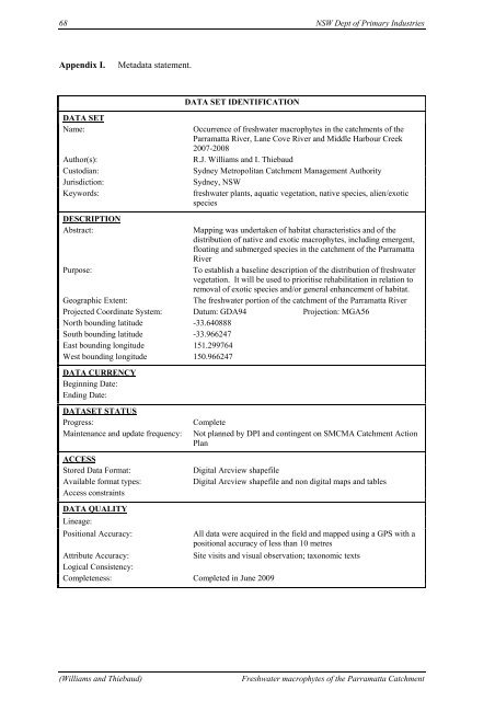
68 NSW Dept <strong>of</strong> Primary Industries<br />
Appendix I. Metadata statement.<br />
DATA SET IDENTIFICATION<br />
DATA SET<br />
Name: Occurrence <strong>of</strong> <strong>freshwater</strong> <strong>macrophytes</strong> in the catchments <strong>of</strong> the<br />
Parramatta River, Lane Cove River and Middle Harbour Creek<br />
2007-2008<br />
Author(s): R.J. Williams and I. Thiebaud<br />
Custodian: Sydney Metropolitan Catchment Management Authority<br />
Jurisdiction: Sydney, NSW<br />
Keywords: <strong>freshwater</strong> plants, aquatic vegetation, native species, alien/exotic<br />
species<br />
DESCRIPTION<br />
Abstract: Mapping was undertaken <strong>of</strong> habitat characteristics and <strong>of</strong> the<br />
distribution <strong>of</strong> native and exotic <strong>macrophytes</strong>, including emergent,<br />
floating and submerged species in the catchment <strong>of</strong> the Parramatta<br />
River<br />
Purpose: To establish a baseline description <strong>of</strong> the distribution <strong>of</strong> <strong>freshwater</strong><br />
vegetation. It will be used to prioritise rehabilitation in relation to<br />
removal <strong>of</strong> exotic species and/or general enhancement <strong>of</strong> habitat.<br />
Geographic Extent: <strong>The</strong> <strong>freshwater</strong> portion <strong>of</strong> the catchment <strong>of</strong> the Parramatta River<br />
Projected Coordinate System: Datum: GDA94 Projection: MGA56<br />
North bounding latitude -33.640888<br />
South bounding latitude -33.966247<br />
East bounding longitude 151.299764<br />
West bounding longitude 150.966247<br />
DATA CURRENCY<br />
Beginning Date:<br />
Ending Date:<br />
DATASET STATUS<br />
Progress: Complete<br />
Maintenance and update frequency: Not planned by DPI and contingent on SMCMA Catchment Action<br />
Plan<br />
ACCESS<br />
Stored Data Format: Digital Arcview shapefile<br />
Available format types: Digital Arcview shapefile and non digital maps and tables<br />
Access constraints<br />
DATA QUALITY<br />
Lineage:<br />
Positional Accuracy: All data were acquired in the field and mapped using a GPS with a<br />
positional accuracy <strong>of</strong> less than 10 metres<br />
Attribute Accuracy: Site visits and visual observation; taxonomic texts<br />
Logical Consistency:<br />
Completeness: Completed in June 2009<br />
(Williams and Thiebaud) Freshwater <strong>macrophytes</strong> <strong>of</strong> the Parramatta Catchment