the stratigraphy and structural history of the mesozoic and cenozoic ...
the stratigraphy and structural history of the mesozoic and cenozoic ...
the stratigraphy and structural history of the mesozoic and cenozoic ...

You also want an ePaper? Increase the reach of your titles
YUMPU automatically turns print PDFs into web optimized ePapers that Google loves.
THE STRATIGRAPHY AND STRUCTURAL HISTORY<br />
OF THE MESOZOIC AND CENOZOIC OF THE CENTRAL<br />
NOVA SCOTIAN SLOPE, EASTERN CANADA<br />
by<br />
© Jennifer Leigh Young, B.Sc. (honours)<br />
A <strong>the</strong>sis submitted to <strong>the</strong> School <strong>of</strong> Graduate Studies in partial fulfillment <strong>of</strong><br />
<strong>the</strong> requirements for <strong>the</strong> degree <strong>of</strong><br />
Masters <strong>of</strong> Science<br />
Department <strong>of</strong> Earth Sciences<br />
Memorial University<br />
April 2005<br />
St. John’s Newfoundl<strong>and</strong> <strong>and</strong> Labrador
Abstract<br />
The continental shelf <strong>and</strong> slope <strong>of</strong> Nova Scotia is underlain by a number <strong>of</strong><br />
interconnected rift sub-basins that collectively form <strong>the</strong> Scotian Basin. Petroleum<br />
exploration companies have been moderately successful on <strong>the</strong> shelf region <strong>of</strong> <strong>the</strong> basin,<br />
close to Sable Isl<strong>and</strong>, where several significant hydrocarbon discoveries have lead to <strong>the</strong><br />
development <strong>of</strong> <strong>the</strong> Sable Project. This success has sparked interest in exploration <strong>of</strong> <strong>the</strong><br />
adjacent frontier slope region within water depths between 200 <strong>and</strong> 2500m. However, <strong>the</strong><br />
Scotian Slope Basin has been <strong>the</strong> focus <strong>of</strong> only limited regional geologic studies. Present<br />
accounts <strong>of</strong> <strong>the</strong> slope are largely extrapolated from shelf descriptions <strong>and</strong>/or modeled<br />
after play types <strong>and</strong> depositional systems typically associated with deep water exploration<br />
in o<strong>the</strong>r Atlantic margin areas. A discrete study area was defined for this project within<br />
<strong>the</strong> central slope region approximately 125 kilometres southwest <strong>of</strong> Sable Isl<strong>and</strong>. The<br />
area is approximately 120 square kilometres <strong>and</strong> contains five <strong>of</strong> <strong>the</strong> ten Scotian Slope<br />
exploration wells, three shelf wells <strong>and</strong> 4 500 kilometres <strong>of</strong> 2D seismic data.<br />
Scotian Basin development commenced in <strong>the</strong> Late Triassic - Early Jurassic with<br />
rifting <strong>of</strong> <strong>the</strong> Pangean Supercontinent <strong>and</strong> opening <strong>of</strong> <strong>the</strong> Atlantic Ocean. Red bed <strong>and</strong><br />
evaporate deposition characterized <strong>the</strong> rift phase, while <strong>the</strong> drift phase was characterized<br />
by clastic progradational with periods <strong>of</strong> carbonate deposition. A prominent carbonate<br />
bank developed in <strong>the</strong> western part <strong>of</strong> <strong>the</strong> basin during <strong>the</strong> Late Jurassic, <strong>the</strong> eastern<br />
extent <strong>of</strong> which was limited by a Late Jurassic - Early Cretaceous Sable Delta. As relative<br />
sea level rose throughout <strong>the</strong> Late Cretaceous <strong>and</strong> Tertiary major transgressive sequences<br />
were deposited. This overall transgression was punctuated by major sea level drops<br />
resulting in <strong>the</strong> deposition <strong>of</strong> regressive lowst<strong>and</strong> sequences partially comprising turbidite<br />
deposits.<br />
Seismic stratigraphic analysis <strong>of</strong> <strong>the</strong> study area identified ten major sequence<br />
boundaries on <strong>the</strong> basis <strong>of</strong> reflection character <strong>and</strong> termination patterns. The sequence<br />
boundaries divide <strong>the</strong> Mesozoic through Cenozoic Scotian Slope Basin fill into nine<br />
depositional sequences. There are major changes in depositional style <strong>and</strong> thickness<br />
distribution patterns <strong>of</strong> <strong>the</strong> depositional sequence through time. Depositional patterns are<br />
closely linked to <strong>the</strong> tectonic, <strong>structural</strong> <strong>and</strong> halotectonic evolution <strong>of</strong> <strong>the</strong> basin.<br />
Five fault families were defined within <strong>the</strong> study on <strong>the</strong> basis <strong>of</strong> <strong>the</strong>ir regionality,<br />
duration <strong>of</strong> movement <strong>and</strong> depths <strong>of</strong> detachment; <strong>the</strong> Slope Basin-Bounding Fault<br />
Family, <strong>the</strong> Basement-Involved Fault Family, <strong>the</strong> Listric Growth Fault Family, <strong>the</strong> Major<br />
<strong>and</strong> Minor Sedimentary Fault Family <strong>and</strong> <strong>the</strong> Halokinetically Induced Fault Family. The<br />
existence <strong>of</strong> a sixth fault family, <strong>the</strong> Transfer Fault Family, is implied by local <strong>structural</strong><br />
<strong>and</strong> stratigraphic architecture, however, <strong>the</strong> signature <strong>of</strong> this potential transfer fault is not<br />
clear enough on <strong>the</strong> available seismic data to allow for confident mapping.<br />
The complete spectrum <strong>of</strong> salt structures typical <strong>of</strong> passive margins has been<br />
identified <strong>and</strong> mapped within <strong>the</strong> study area. Five halotectonic <strong>structural</strong> associations<br />
with variable areal distributions have been identified. These associations are: <strong>the</strong> Trough<br />
<strong>and</strong> Swell Association, <strong>the</strong> Intra-Salt Detachment Association, <strong>the</strong> Diapiric Association,<br />
<strong>the</strong> Secondary Weld Association, <strong>and</strong> <strong>the</strong> Allochthonous Salt Association.<br />
ii
The integration <strong>of</strong> seismic stratigraphic, <strong>structural</strong> <strong>and</strong> halotectonic analysis <strong>of</strong> <strong>the</strong><br />
study area allowed for several conclusions regarding implications <strong>of</strong> a potential Scotian<br />
Slope petroleum system to be proposed. Considering all <strong>the</strong> elements <strong>and</strong> processes<br />
necessary for working hydrocarbon system, <strong>the</strong> most likely plays within <strong>the</strong> mapped<br />
study area consist <strong>of</strong>: 1) a reservoir <strong>of</strong> Cretaceous to Tertiary turbidite channel, levee or<br />
lobe s<strong>and</strong>s, 2) a source rock most likely within <strong>the</strong> Kimmeridgian Verrill Canyon<br />
Formation (possible contribution from Jurassic Mohican Formation or Late Triassic to<br />
Early Jurassic early Syn-rift <strong>and</strong>/or Post-rift Lacustrine deposits, 3) a seal <strong>of</strong> Verrill<br />
Canyon Formation, Dawson Canyon or Banquereau shale or allochthonous salt, <strong>and</strong> 4)<br />
<strong>structural</strong>, tectonic <strong>and</strong>/or halokinetic traps ranging from Triassic to Cretaceous in age.<br />
Failure to discover hydrocarbons in recent slope explorations wells may point to<br />
<strong>the</strong> limitations <strong>of</strong> seismic resolution to predict reservoirs within <strong>the</strong> late Jurassic-Early<br />
Cretaceous successions. It also shows that drilling on <strong>the</strong> Scotian Slope is high risk<br />
exploration; more regional <strong>and</strong> better correlation <strong>of</strong> seismic with lithologies encountered<br />
in <strong>the</strong> wells are needed.<br />
iii
Acknowledgements<br />
I would like to start by thanking Andy Pulham for making this project possible. I<br />
am very fortunate that he, toge<strong>the</strong>r with Elliott Burden, Ralph Rudser <strong>and</strong> Tom Koleszar,<br />
thought up this project over a “lively supper” <strong>and</strong> accepted me as a willing graduate<br />
student. Andy has taken care <strong>of</strong> most <strong>of</strong> <strong>the</strong> logistics <strong>of</strong> this project <strong>and</strong> provided valuable<br />
guidance as well as partial funding. I would like to say thank-you to Tom Calon for his<br />
time <strong>and</strong> guidance, especially with respect to <strong>structural</strong> interpretation. I would also like to<br />
thank Michael Enachescu for his enthusiasm <strong>and</strong> willingness to share his expertise,<br />
speedy <strong>and</strong> thorough revisions, <strong>and</strong> general encouragement, all <strong>of</strong> which I am extremely<br />
grateful for.<br />
I would like to acknowledge Kim Abdallah <strong>of</strong> TGS-NOPEC <strong>and</strong> Ralph Rudser <strong>of</strong><br />
BP Canada as being instrumental in facilitating <strong>the</strong> data access for this <strong>the</strong>sis. I would<br />
like to thank TGS-NOPEC for providing <strong>the</strong> seismic data set <strong>and</strong> L<strong>and</strong>mark for donating<br />
to Memorial University <strong>the</strong> interpretation s<strong>of</strong>tware used in this study. I would like to<br />
acknowledge BP Canada Corporation for partially funding <strong>the</strong> project <strong>and</strong> providing<br />
digital well data. I am very grateful for <strong>the</strong> primary funding provided by PanAtlantic<br />
Petroleum Systems Consortium. Thank-you to <strong>the</strong> Geologic Survey <strong>of</strong> Canada Atlantic<br />
for providing access to <strong>the</strong>ir Basin Data Base, to EnCana Corporation <strong>and</strong> John Hogg for<br />
providing Figure 2-10, <strong>and</strong> to Seismic Micro-Technologies <strong>and</strong> Geo-Logic Systems who<br />
donated s<strong>of</strong>tware.<br />
A very big thank-you is owed to Tony Kocurko who gave so much <strong>of</strong> his time to<br />
loading data <strong>and</strong> general trouble shooting. A special thanks to Ali Aksu for always<br />
iv
leaving his door open <strong>and</strong> helping me see <strong>the</strong> light at <strong>the</strong> end <strong>of</strong> <strong>the</strong> tunnel when things<br />
became overwhelming. I would also like to thank a number <strong>of</strong> people who gave helpful<br />
discussions, instructions <strong>and</strong>/or technical assistance: Ian Atkinson, Sharon Deemer, Rick<br />
Hiscott, Rudi Meyer, Ray Pätzold, Darren Smith, Krista Solvason, Jim Wright <strong>and</strong><br />
Richard Wright. I would also like to thank Gerchard Pfau, Don Tanasichuck <strong>and</strong> <strong>the</strong> rest<br />
<strong>of</strong> <strong>the</strong> 2002 BP Canada East Coast Team for <strong>the</strong>ir encouragement, guidance <strong>and</strong> helpful<br />
discussions. Thanks to <strong>the</strong> many student colleagues that I have met <strong>and</strong> had <strong>the</strong> pleasure<br />
to work <strong>and</strong>/or procrastinate with <strong>and</strong> who have helped to make this experience<br />
pleasurable. Thanks to my <strong>of</strong>ficemate Rodrigo Sala for stimulating conversations,<br />
encouragement, great c<strong>of</strong>fee breaks, <strong>and</strong> for putting up with me.<br />
Thank you to my mo<strong>the</strong>r Marie Young, fa<strong>the</strong>r <strong>and</strong> stepmo<strong>the</strong>r Richard <strong>and</strong> W<strong>and</strong>a<br />
Young <strong>and</strong> my bro<strong>the</strong>r Philip Young who have always believed in me. Without <strong>the</strong>ir<br />
unconditional support I could never have accomplished what I have. Last but not least, I<br />
would like to thank Cory St. Croix whose love, support, <strong>and</strong> self-sacrifice have been my<br />
inspiration.<br />
v
Table <strong>of</strong> Contents<br />
Title Page i<br />
Abstract ii<br />
Acknowledgements iv<br />
List <strong>of</strong> Figures ix<br />
Chapter 1: Introduction<br />
1.1 Introduction to <strong>the</strong> Scotian Slope 1<br />
1.2 Background <strong>and</strong> Previous Work 4<br />
1.3 Purpose 7<br />
1.4 Research Objectives 10<br />
1.5 Data <strong>and</strong> Methods 10<br />
Chapter 2: Geography, Stratigraphy <strong>and</strong> Structure<br />
2.1 Geography 18<br />
2.2 Regional Geology 20<br />
2.3 Stratigraphy <strong>and</strong> Mesozoic Basin Development 21<br />
2.4 Structural Styles <strong>and</strong> Geometry 33<br />
2.4.1 Thick Skin Deformation 33<br />
2.4.2 Thin Skin Deformation 37<br />
2.4.3 Halotectonics 39<br />
Chapter 3: Seismic Stratigraphy<br />
3.1 Introduction 42<br />
3.2 Well Control 42<br />
3.2.1 Syn<strong>the</strong>tic Seismograms 44<br />
3.2.2 Correlating Seismic Events 44<br />
3.3 Seismic Stratigraphy 50<br />
3.3.1 Top Basement Marker 53<br />
3.3.2 Tr1 Sequence Boundary 55<br />
3.3.3 Depositional Sequence 1 57<br />
vi
3.3.4 Tr2 Sequence Boundary 57<br />
3.3.5 Depositional Sequence 2 60<br />
3.3.6 J1 Sequence Boundary 65<br />
3.3.7 Depositional Sequence 3 68<br />
3.3.8 J2 Sequence Boundary 69<br />
3.3.9 Top Abenaki Formation Marker 72<br />
3.3.10 Depositional Sequence 4 73<br />
3.3.11 The O Marker 77<br />
3.3.12 K1 Sequence Boundary 78<br />
3.3.13 Depositional Sequence 5 79<br />
3.3.14 T0 Sequence Boundary 82<br />
3.3.15 Depositional Sequence 6 85<br />
3.3.16 T1 Sequence Boundary 87<br />
3.3.17 Depositional Sequence 7 89<br />
3.3.18 T2 Sequence Boundary 91<br />
3.3.19 Depositional Sequence 8 91<br />
3.3.20 T3 Sequence Boundary 95<br />
3.3.21 Depositional Sequence 9 97<br />
3.3.22 Water bottom 99<br />
Chapter 4: Tectonics<br />
4.1 Introductory Remarks 101<br />
4.2 Structural Elements 101<br />
4.2.1 Slope Basin-Bounding Fault Family 107<br />
4.2.2 Basement-Involved Fault Family 108<br />
4.2.3 Listric Growth Fault Family 114<br />
4.2.4 Major <strong>and</strong> Minor Sedimentary Fault Family 117<br />
4.2.5 The Halokinetically Induced Fault Family 122<br />
4.2.6 The Transfer Fault Family 124<br />
Chapter 5: Salt Tectonics<br />
5.1 Mechanics <strong>and</strong> Geometries <strong>of</strong> Salt Deformation 125<br />
5.2 Map Distribution <strong>and</strong> Style Characteristics <strong>of</strong> Salt 132<br />
vii
5.3 Halotectonic Structural Associations 136<br />
5.3.1 The Trough <strong>and</strong> Swell Association 136<br />
5.3.2 The Intra-Salt Detachment Association 137<br />
5.3.3 The Diapiric Association 142<br />
5.3.4 The Secondary Weld Association 155<br />
5.3.5 The Allochthonous Salt Association 158<br />
5.4 Kinematic Analysis <strong>of</strong> Salt Structures 170<br />
5.4.1 Introduction 170<br />
5.4.2 Salt Movement <strong>and</strong> Sedimentation 173<br />
Chapter 6: Evolution <strong>of</strong> <strong>the</strong> Scotian Slope Basin: Discussion<br />
6.1 Evolution <strong>of</strong> <strong>the</strong> Scotian Slope Basin 184<br />
6.1.1 Pre-Mesozoic 184<br />
6.1.2 Late Triassic to Early Jurassic 190<br />
6.1.3 Middle to Late Jurassic 193<br />
6.1.4 Cretaceous 196<br />
6.1.5 Tertiary 198<br />
6.1.6 Quaternary 200<br />
6.2 Implications for a Scotian Slope Petroleum System 202<br />
Chapter 7: Conclusions <strong>and</strong> Recommendations for Future Work<br />
7.1 Justifications for <strong>the</strong> Study 214<br />
7.2 Key Conclusions 215<br />
7.3 Recommendations for Future Work 220<br />
References 221<br />
viii
List <strong>of</strong> Figures (Short Titles)<br />
1-1 Bathymetry, political boundaries, petroleum exploration licenses <strong>and</strong><br />
study area <strong>of</strong> <strong>the</strong> Nova Scotia continental margin 2<br />
1-2 Comparative stratigraphic chart <strong>of</strong> Scotian Basin <strong>and</strong> Atlantic margin<br />
analogs 9<br />
1-3 Basemap <strong>of</strong> TGS-NOPEC seismic data used in study 11<br />
1-4 Example TGS-NOPEC seismic line 13<br />
1-5 Basemap <strong>of</strong> Lithoprobe seismic data used in study 14<br />
1-6 Basemap <strong>of</strong> exploration wells located on <strong>the</strong> Scotian Slope <strong>and</strong> those<br />
within study area 16<br />
2-1 Regional Tectonic Elements <strong>of</strong> Atlantic Canada 19<br />
2-2 Schematic cross-section A-A’ through Scotian Basin 22<br />
2-3 Litho<strong>stratigraphy</strong> <strong>of</strong> <strong>the</strong> Scotian Shelf 23<br />
2-4 Cross-section B-B’ <strong>of</strong> Glooscap C-63, Moheida P-15, Mohican I-100<br />
<strong>and</strong> Acadia K-62 wells 26<br />
2-5 Generalized facies distribution <strong>of</strong> <strong>the</strong> Abenaki <strong>and</strong> equivalent formations 28<br />
2-6 Multibeam bathymetric image <strong>of</strong> central Scotian Slope 32<br />
2-7 Basement structure <strong>of</strong> <strong>the</strong> Scotian Basin 34<br />
2-8 Tectonic reconstruction <strong>of</strong> Orpheus <strong>and</strong> Scotian basins 36<br />
2-9 Regional geologic cross-section C-C’ across <strong>the</strong> Scotian Shelf <strong>and</strong> Slope 38<br />
2-10 Scotian Margin basemap showing bathymetry, lease block boundaries,<br />
study area <strong>and</strong> salt body distribution 41<br />
3-1 Seismic pr<strong>of</strong>ile showing key seismic surfaces (1-10) <strong>and</strong> o<strong>the</strong>r<br />
significant surfaces 43<br />
3-2 Syn<strong>the</strong>tic seismogram <strong>of</strong> <strong>the</strong> Oneida O-25 well 45<br />
ix
3-3 Lithoprobe 88-1a seismic pr<strong>of</strong>ile 47<br />
3-4 Generalized Scotian Basin <strong>stratigraphy</strong>, M.Sc. sequence boundaries or<br />
seismic markers, name <strong>and</strong> correlation confidence, depositional<br />
sequences <strong>and</strong> Deep Sea Drilling Project seismic markers 49<br />
3-5 Seismic pr<strong>of</strong>ile showing reflection termination patterns <strong>of</strong> sequence<br />
boundaries 51<br />
3-6 Seismic pr<strong>of</strong>ile showing example <strong>of</strong> Top Basement Marker 54<br />
3-7 Seismic pr<strong>of</strong>ile <strong>and</strong> schematic showing relationship between top<br />
basement marker, Tr1 <strong>and</strong> Tr2 sequence boundaries <strong>and</strong> Depositional<br />
Sequence 1 56<br />
3-8 Time structure map <strong>of</strong> <strong>the</strong> Tr2 Sequence Boundary 59<br />
3-9 Seismic pr<strong>of</strong>ile D-D’ showing seismic tie with Moheida P-15 well 61<br />
3-10 Seismic line E-E’ showing seismic tie with Glooscap C-63, Oneida O-25<br />
<strong>and</strong> Evangeline H-100 wells 62<br />
3-11 Seismic section showing typical reflection character <strong>of</strong> salt 64<br />
3-12 Time structure map <strong>of</strong> <strong>the</strong> J1 Sequence Boundary 67<br />
3-13 Isochron map <strong>of</strong> Depositional Sequence 3 70<br />
3-14 Time structure map <strong>of</strong> <strong>the</strong> J2 Sequence Boundary 71<br />
3-15 Time structure map <strong>of</strong> <strong>the</strong> top Abenaki Formation marker 74<br />
3-16 Isochron map <strong>of</strong> Depositional Sequence 4 76<br />
3-17 Seismic line showing relationship between sequence boundaries K1, T0,<br />
T1, T2, T3 <strong>and</strong> depositional sequences 5-9 80<br />
3-18 Isochron map <strong>of</strong> Depositional Sequence 5 81<br />
3-19 Seismic pr<strong>of</strong>ile showing seismic tie with Shubenacadie H-100 well 83<br />
3-20 Time structure map <strong>of</strong> <strong>the</strong> T0 Sequence Boundary 84<br />
3-21 Isochron map <strong>of</strong> Depositional Sequence 6 86<br />
x
3-22 Time structure map <strong>of</strong> <strong>the</strong> T1 Sequence Boundary 88<br />
3-23 Isochron map <strong>of</strong> Depositional Sequence 7 90<br />
3-24 Time structure map <strong>of</strong> <strong>the</strong> T2 Sequence Boundary 92<br />
3-25 Isochron map <strong>of</strong> Depositional Sequence 8 94<br />
3-26 Time structure map <strong>of</strong> <strong>the</strong> T3 Sequence Boundary 96<br />
3-27 Isochron map <strong>of</strong> Depositional Sequence 9 98<br />
3-28 Time structure map <strong>of</strong> <strong>the</strong> water bottom 100<br />
4-1 Time structure map <strong>of</strong> <strong>the</strong> Tr2 Sequence Boundary showing spatial<br />
distribution <strong>of</strong> <strong>the</strong> Basin-Bounding Fault Family <strong>and</strong> <strong>the</strong> Basement-<br />
Involved Fault Family 103<br />
4-2 Seismic pr<strong>of</strong>ile A-A’ with examples <strong>of</strong>: Basin-Bounding Fault Family,<br />
Basement-Involved Fault Family, Listric Growth Fault Family, Major<br />
<strong>and</strong> minor Fault Family, <strong>and</strong> <strong>the</strong> Halokinetically induced Fault Family 105<br />
4-3 Seismic pr<strong>of</strong>ile B-B’ showing structure typical <strong>of</strong> <strong>the</strong> Basement-<br />
Involved Fault Family 110<br />
4-4 Portion <strong>of</strong> seismic pr<strong>of</strong>ile A-A’ showing anomalous pre-Mesozoic<br />
reflector configuration, <strong>and</strong> example <strong>of</strong> similar structure from <strong>the</strong> Jeanne<br />
d’Arc Basin 113<br />
4-5 Seismic pr<strong>of</strong>ile with example <strong>of</strong> Listric Growth Fault Family 115<br />
4-6 a) Seismic pr<strong>of</strong>ile with example <strong>of</strong> a group <strong>of</strong> related listric faults soling<br />
into a common level <strong>of</strong> detachment, <strong>and</strong> b) Example <strong>of</strong> listric growth<br />
fault with salt-cored anticline 116<br />
4-7 Seismic strike line with example <strong>of</strong> two major faults detaching on salt 118<br />
4-8 Close-up <strong>of</strong> seismic pr<strong>of</strong>ile A-A’ showing major <strong>and</strong> minor faults 121<br />
4-9 Seismic strike line showing examples <strong>of</strong> minor faults associated with<br />
pock marks 123<br />
xi
5-1 Block diagram showing schematic shapes <strong>of</strong> salt structures by <strong>structural</strong><br />
maturity <strong>and</strong> size 128<br />
5-2 Schematic diagram <strong>of</strong> typical stress <strong>and</strong> strain domains in a clastic<br />
passive continental margin 130<br />
5-3 Tectono-stratigraphic provinces <strong>of</strong> <strong>the</strong> nor<strong>the</strong>rn Gulf <strong>of</strong> Mexico Basin 131<br />
5-4 Time structure map <strong>of</strong> <strong>the</strong> top <strong>of</strong> salt horizon 133<br />
5-5 Map distribution <strong>of</strong> halotectonic <strong>structural</strong> associations <strong>and</strong> <strong>the</strong>ir broad<br />
domanial distribution 135<br />
5-6 A) Section <strong>of</strong> seismic pr<strong>of</strong>ile showing example <strong>of</strong> salt trough <strong>and</strong> swell,<br />
B) Schematic diagram showing relationship between basement faulting<br />
<strong>and</strong> swell formation 137<br />
5-7 Two seismic pr<strong>of</strong>ile sections showing examples <strong>of</strong> salt structures typical<br />
<strong>of</strong> <strong>the</strong> Intra-Salt Detachment association 140<br />
5-8 Stages <strong>of</strong> diapir initiation <strong>and</strong> growth during extension 144<br />
5-9 Salt structure geometries as controlled by salt supply <strong>and</strong> sedimentation 145<br />
5-10 SW-NE seismic strike line A-A’ with examples <strong>of</strong> salt structures typical<br />
<strong>of</strong> <strong>the</strong> Diapiric association 147<br />
5-11 SW-NE seismic strike line B-B’ with examples <strong>of</strong> salt structures typical<br />
<strong>of</strong> <strong>the</strong> Diapiric association 148<br />
5-12 SW-NE seismic pr<strong>of</strong>ile C-C’ with examples <strong>of</strong> salt structures typical <strong>of</strong><br />
<strong>the</strong> Diapiric association 150<br />
5-13 SW-NE seismic pr<strong>of</strong>ile D-D’ with examples <strong>of</strong> salt structures typical <strong>of</strong><br />
<strong>the</strong> Diapiric association 151<br />
5-14 Diapir rejuvenation during contraction 153<br />
5-15 Portion <strong>of</strong> NW-SE seismic pr<strong>of</strong>ile with example <strong>of</strong> rejuvenated<br />
“hourglass” shaped diapir with vertical secondary weld at middle stem 156<br />
5-16 Portion <strong>of</strong> NW-SE seismic pr<strong>of</strong>ile with example <strong>of</strong> inclined secondary<br />
weld as feeder to a basinward tilted diapir 157<br />
xii
5-17 End member geometries <strong>of</strong> allochthonous salt systems 160<br />
5-18 Seismic strike line E-E’ with examples <strong>of</strong> salt structures typical <strong>of</strong> <strong>the</strong><br />
Allochthonous Salt association 162<br />
5-19 Seismic strike lone F-F’ with examples <strong>of</strong> allochthonous salt stocks,<br />
coalesced out <strong>of</strong> <strong>the</strong> plane <strong>of</strong> section 163<br />
5-20 A) Seismic pr<strong>of</strong>ile G-G’ with example <strong>of</strong> allochthonous stepped<br />
counterregional salt tongue, B) Schematic evolution <strong>of</strong> a stepped<br />
counterregional salt tongue system 165<br />
5-21 Schematic evolution <strong>of</strong> an allochthonous roho salt tongue system 167<br />
5-22 Seismic pr<strong>of</strong>ile H-H’ with example <strong>of</strong> questionable roho salt tongue<br />
system 168<br />
5-23 Seismic pr<strong>of</strong>ile from <strong>the</strong> west map area with temporal kinematic stages<br />
<strong>of</strong> diapir evolution highlighted 179<br />
5-24 Seismic strike line from <strong>the</strong> western portion <strong>of</strong> <strong>the</strong> central slope region<br />
with temporal kinematic stages <strong>of</strong> diapir evolution highlighted 181<br />
5-25 Seismic strike line from <strong>the</strong> eastern portion <strong>of</strong> <strong>the</strong> central slope region<br />
with temporal kinematic stages <strong>of</strong> diapir evolution highlighted 183<br />
6-1 Seismic pr<strong>of</strong>ile from <strong>the</strong> western map area with 6 tectono-stratigraphic<br />
mega-sequences highlighted 186<br />
6-2 Tectono-stratigraphic compilation chart <strong>of</strong> <strong>the</strong> Scotian Basin<br />
summarizing lithology, litho<strong>stratigraphy</strong>, sequence boundaries <strong>and</strong><br />
depositional sequences, tectono-stratigraphic mega-sequences <strong>and</strong><br />
<strong>structural</strong> styles 188<br />
6-3 Schematic block diagram <strong>of</strong> <strong>the</strong> Early Jurassic structure <strong>of</strong> <strong>the</strong> study area 191<br />
6-4 Structuring <strong>of</strong> salt walls by four types <strong>of</strong> stress regimes 194<br />
6-5 A) Portion <strong>of</strong> seismic pr<strong>of</strong>ile with example <strong>of</strong> channel levee, B)<br />
Spectrum <strong>of</strong> turbidite channels contrasting <strong>the</strong> geometric <strong>and</strong><br />
depositional attributes <strong>of</strong> erosional <strong>and</strong> depositional types as a function<br />
<strong>of</strong> texture <strong>and</strong> sediment transport, C) Geomorphic elements <strong>of</strong> a turbidite<br />
channel/lobe complex. 204<br />
xiii
6-6 Burial <strong>history</strong> for <strong>the</strong> western-central Scotian Slope. 207<br />
6-7 Isochron map <strong>of</strong> Sequence Boundary J2 to Water Bottom. 208<br />
xiv
Chapter 1<br />
Introduction<br />
1.1 Introduction to <strong>the</strong> Scotian Slope<br />
The Nova Scotian Continental Slope <strong>of</strong> south-eastern Canada has recently become<br />
an attractive frontier region for hydrocarbon exploration (Hogg, 2000). The slope lies<br />
sou<strong>the</strong>ast <strong>of</strong> <strong>the</strong> Nova Scotian Shelf where successful hydrocarbon discoveries <strong>and</strong><br />
subsequent production have spurred <strong>the</strong> search for new resources in <strong>the</strong> adjacent deeper<br />
water. The Scotian Slope is approximately 850 kilometers in length <strong>and</strong> 100 kilometres in<br />
width <strong>and</strong>, <strong>the</strong>refore, represents a very large exploration region (Figure 1-1). To date, ten<br />
exploration wells have been drilled on <strong>the</strong> slope.<br />
The passive continental margin <strong>of</strong> Eastern Canada is characterized by a series <strong>of</strong><br />
deep sedimentary basins above a wide zone <strong>of</strong> significantly thinned continental crust.<br />
Faulting style <strong>and</strong> basin geometry vary laterally along <strong>the</strong> margin. The margin evolved<br />
subsequent to <strong>the</strong> Late Triassic rifting <strong>of</strong> <strong>the</strong> Pangean super-continent (Tankard <strong>and</strong><br />
Balkwill, 1989). In <strong>the</strong> area <strong>of</strong>f Nova Scotia, rifting resulted in a series on interconnected<br />
sub-basins that collectively form <strong>the</strong> Mesozoic Scotian Basin. Ensuing basin<br />
development <strong>and</strong> sediment accumulation created conditions suitable for <strong>the</strong> generation<br />
<strong>and</strong> preservation <strong>of</strong> hydrocarbons.<br />
In <strong>the</strong> Scotian Basin, red bed <strong>and</strong> evaporite deposition characterized <strong>the</strong> rift phase,<br />
while <strong>the</strong> drift phase was characterized by typical clastic progradational sequences with<br />
periods <strong>of</strong> carbonate deposition (Kidston et. al., 2002). A prominent carbonate bank<br />
1
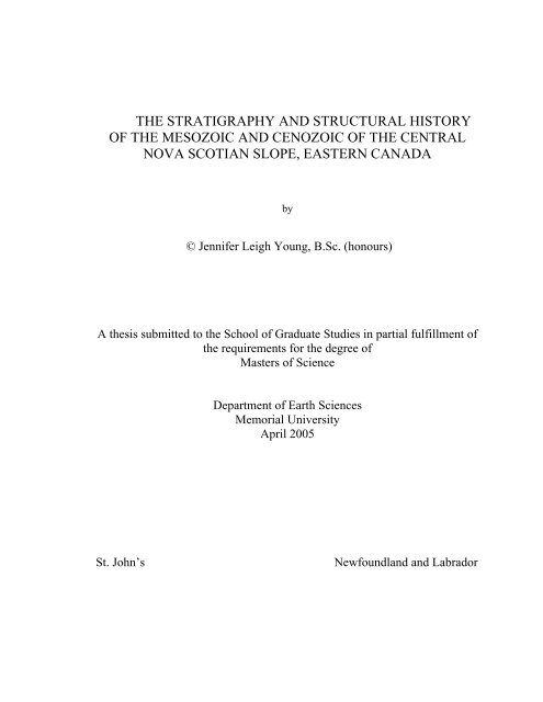
2<br />
Figure 1.1: Bathymetry, political boundaries, petroleum lease blocks <strong>and</strong> study area <strong>of</strong> <strong>the</strong> Scotian Margin.<br />
Figure modified from Canada-Nova Scotia Offshore Petroleum Board (2004).
developed in <strong>the</strong> western part <strong>of</strong> <strong>the</strong> basin during <strong>the</strong> Late Jurassic, <strong>the</strong> eastern extent <strong>of</strong><br />
which was limited by a major deltaic depocenter located in <strong>the</strong> Sable Isl<strong>and</strong> area during<br />
<strong>the</strong> Late Jurassic to Early Cretaceous. Major transgressive sequences were deposited as<br />
relative sea level rose throughout <strong>the</strong> Late Cretaceous <strong>and</strong> Tertiary (Wade <strong>and</strong> MacLean,<br />
1990). This overall general transgression was punctuated by major sea level falls<br />
resulting in <strong>the</strong> deposition <strong>of</strong> regressive lowst<strong>and</strong> sequences (Kidston et. al, 2002). These<br />
potential reservoir sediments were deposited as submarine channels, lobes <strong>and</strong> fans in<br />
areas <strong>of</strong> accommodation on <strong>the</strong> slope or basin floor. Movement <strong>of</strong> Late Triassic- to Early<br />
Jurassic–aged salt largely controlled <strong>the</strong> creation <strong>and</strong> distribution <strong>of</strong> accommodation<br />
space through <strong>the</strong> formation <strong>of</strong> salt withdrawal minibasins. Sediment loading continued<br />
to drive halokenitics during <strong>the</strong> Tertiary resulting in <strong>the</strong> configuration <strong>of</strong> salt swells,<br />
walls, ridges, <strong>and</strong> domes seen today.<br />
A regional 2D grid <strong>of</strong> high quality reflection seismic data has recently been<br />
acquired over <strong>the</strong> Scotian Slope. The detailed analysis <strong>of</strong> this seismic grid <strong>and</strong> <strong>the</strong><br />
integration <strong>of</strong> seismic <strong>stratigraphy</strong> with well data are in <strong>the</strong> early stages <strong>and</strong> are mostly<br />
being undertaken by exploration groups <strong>of</strong> oil <strong>and</strong> gas companies <strong>and</strong> <strong>the</strong> government<br />
regulatory board (Canadian-Nova Scotia Offshore Petroleum Board). The current<br />
exploration emphasis is on an improved underst<strong>and</strong>ing <strong>of</strong> <strong>the</strong> slope seismic <strong>stratigraphy</strong>,<br />
petroleum systems <strong>of</strong> <strong>the</strong> region <strong>and</strong> definition <strong>of</strong> prospective plays.<br />
3
1.2 Background <strong>and</strong> Previous Work<br />
There is limited government <strong>and</strong> academic literature that discusses <strong>the</strong> Scotian<br />
Slope area <strong>and</strong> setting based on recent drilling information <strong>and</strong> seismic data. However,<br />
<strong>the</strong>re are specific papers that describe <strong>and</strong> discuss <strong>the</strong> adjacent Scotian Shelf <strong>and</strong> regional<br />
basins. In recent years exploration groups <strong>of</strong> several oil <strong>and</strong> gas companies have<br />
produced <strong>the</strong> majority <strong>of</strong> publicly available information pertaining to <strong>the</strong> slope region,<br />
mostly as short articles or conference presentations.<br />
Modern exploration <strong>of</strong> <strong>the</strong> Scotian Shelf commenced in 1948 when ships <strong>of</strong> <strong>the</strong><br />
Lamont Geological Survey, under <strong>the</strong> direction <strong>of</strong> Maurice Ewing, carried out seismic<br />
refraction surveys across much <strong>of</strong> Canada’s sou<strong>the</strong>astern continental shelf (Sherwin,<br />
1973). The results <strong>of</strong> this study, <strong>and</strong> those <strong>of</strong> two subsequent voyages in 1950 <strong>and</strong> 1951,<br />
were first published in 1954 by Drake et al., Officer <strong>and</strong> Ewing, <strong>and</strong> Press <strong>and</strong><br />
Beckmann. These studies provided evidence that Eastern Canada’s Continental Margin<br />
was comprised <strong>of</strong> a thick sedimentary succession overlying a basement complex <strong>of</strong> high<br />
velocity igneous <strong>and</strong> metamorphic rocks (Sherwin, 1973).<br />
The Canadian Government first became involved in geological investigation <strong>of</strong><br />
Canada’s eastern continental margin in 1955 when <strong>the</strong> Nova Scotia Research Foundation<br />
<strong>and</strong> Dominion Observatory conducted seismic refraction studies in <strong>the</strong> Sable Isl<strong>and</strong> area.<br />
Results <strong>of</strong> <strong>the</strong>se studies were published by Willomore <strong>and</strong> Tolmie (1956). In 1964 <strong>and</strong><br />
1965 Dalhousie University carried out deep refraction surveys on <strong>the</strong> Scotian Shelf,<br />
continental slope <strong>and</strong> rise beyond (Barrett et al., 1964; Keen <strong>and</strong> Loncarevic, 1966).<br />
4
Areomagnetic surveys <strong>of</strong> <strong>the</strong> North Atlantic continental shelf were first conducted<br />
by Lamont Geological Survey in 1955 <strong>and</strong> 1957 <strong>and</strong> extended by <strong>the</strong> Geological Survey<br />
<strong>of</strong> Canada (G.S.C) in 1958, 1959 <strong>and</strong> 1960 over <strong>the</strong> Scotian Shelf (Sherwin, 1973).<br />
Aeromagnetic mapping <strong>and</strong> interpretation was reported by Bhattacharyya <strong>and</strong><br />
Raychaudhuri (1967). Sea magnetometer programs were conducted over <strong>the</strong> Scotian<br />
Shelf by <strong>the</strong> G.S.C in 1960 <strong>and</strong> 1963 <strong>and</strong> described by Bower (1962) <strong>and</strong> Hood (1966a,<br />
1966b).<br />
The petroleum industry first become actively interested in <strong>the</strong> petroleum potential<br />
<strong>of</strong> Eastern Canada’s continental shelf in 1959, when Mobil Oil Canada conducted both<br />
aeromagnetic <strong>and</strong> seismic surveys <strong>of</strong> <strong>the</strong> Sable Isl<strong>and</strong> area (Sherwin, 1973). In 1960<br />
Mobil Oil filed in a small block <strong>of</strong> federal oil <strong>and</strong> gas permits on <strong>and</strong> around Sable Isl<strong>and</strong>.<br />
The situation remained static until 1963, when Shell Canada filed in 20 million acres <strong>of</strong><br />
federal permits, covering most <strong>of</strong> <strong>the</strong> Scotian Shelf (Sherwin, 1973). In 1967, Mobil Oil<br />
Canada’s Sable Isl<strong>and</strong> C-67 was <strong>the</strong> first well spudded on <strong>the</strong> Scotian Shelf. It was drilled<br />
on Sable Isl<strong>and</strong> to a depth <strong>of</strong> 4 600 m <strong>and</strong> found minor amounts <strong>of</strong> oil <strong>and</strong> gas (GSC<br />
Basin Database, 2004). The stratigraphic succession <strong>of</strong> well C-67 was described by<br />
Magnusson (1973).<br />
The continental slope, rise <strong>and</strong> abyssal plain <strong>of</strong> Nova Scotia were investigated by<br />
Uchupi (1965, 1968, 1969) <strong>and</strong> Emery <strong>and</strong> Uchupi (1965) <strong>and</strong> Emery et al. (1970), using<br />
seismic reflection gravity <strong>and</strong> magnetic data collected by Woods Hole Oceanographic<br />
Institute <strong>and</strong> <strong>the</strong> United States Geological Survey. In 1970 two publications, one by<br />
5
Emery et al. <strong>and</strong> <strong>the</strong> o<strong>the</strong>r by King <strong>and</strong> MacLean reported <strong>the</strong> presence <strong>of</strong> diapiric<br />
structures beneath <strong>the</strong> continental slope <strong>of</strong>f <strong>the</strong> Scotian Shelf.<br />
McIver (1972), in a major contribution based on information from exploratory<br />
wells <strong>and</strong> processed seismic data, proposed a stratigraphic framework <strong>and</strong> described <strong>the</strong><br />
succession underlying <strong>the</strong> Scotian Shelf. Sherwin (1973) later discussed <strong>the</strong> geology <strong>and</strong><br />
hydrocarbon potential <strong>of</strong> <strong>the</strong> Scotian Shelf <strong>and</strong> Gr<strong>and</strong> Banks. Subsequently, through<br />
analysis <strong>of</strong> commercial seismic <strong>and</strong> well data, <strong>the</strong> geological framework <strong>of</strong> <strong>the</strong> Scotian<br />
Shelf was refined by Hardy (1975), Jansa <strong>and</strong> Wade (1975), Wade <strong>and</strong> McLean (1990),<br />
<strong>and</strong> Wade et al. (1995). In 1990 Bell <strong>and</strong> Campbell reexamined <strong>the</strong> petroleum potential <strong>of</strong><br />
<strong>of</strong>fshore Eastern Canada, including <strong>the</strong> Scotian Shelf <strong>and</strong> slope.<br />
Sea floor bathymetry, sediment instability <strong>and</strong> o<strong>the</strong>r process that are currently<br />
shaping <strong>the</strong> Scotian Slope are <strong>the</strong> subjects <strong>of</strong> considerable past <strong>and</strong> current research by<br />
<strong>the</strong> Geological Survey <strong>of</strong> Canada (GSC), e.g. (Keen et al., 1991), (Keen <strong>and</strong> Kay, 1991),<br />
(Keen <strong>and</strong> Potter, 1995), (Pickrill, et. al, 2001), (Piper et. al, 1985, 1999), (Swift, 1987)<br />
<strong>and</strong> Dalhousie University e.g. (Hill <strong>and</strong> Bowen, 1983), (Berry <strong>and</strong> Piper, 1993), <strong>and</strong><br />
(Gauley, 2001).<br />
The GSC, as part <strong>of</strong> <strong>the</strong> East Coast Basin Atlas Series (1991), compiled a<br />
collection <strong>of</strong> geological <strong>and</strong> geophysical studies relating to <strong>the</strong> Scotian Shelf. An<br />
excellent synopsis <strong>of</strong> <strong>the</strong> geology <strong>and</strong> hydrocarbon potential <strong>of</strong> <strong>the</strong> deep water Scotian<br />
Slope was produced by <strong>the</strong> Canadian-Nova Scotia Offshore Petroleum Board (Kidston et.<br />
al, 2002). Research on <strong>the</strong> source rock potential <strong>of</strong> <strong>the</strong> Scotian Slope is being conducted<br />
6
y Mukhopadhyay <strong>and</strong> Wade (1990), Williamson <strong>and</strong> Smyth (1992), Mukhopadhyay<br />
(1995), <strong>and</strong> Mukhopadhyay et al., (2002)<br />
Commercial 2D reflection seismic collected by various contractors now covers<br />
over 30 000 km <strong>of</strong> <strong>the</strong> basin, extending from <strong>the</strong> Georges Banks to <strong>the</strong> South Whale<br />
Basin. Proprietary 3D seismic surveys have been acquired by petroleum exploration<br />
companies in localized areas <strong>of</strong> interest. The detailed analysis <strong>of</strong> newly acquired seismic<br />
<strong>and</strong> well data is mostly being undertaken within exploration groups <strong>of</strong> oil <strong>and</strong> gas<br />
companies. EnCana Corporation, formally PanCanadian Petroleum Ltd., has been<br />
especially active in exploration <strong>and</strong> promotion <strong>of</strong> <strong>the</strong> Scotian Slope (e.g. Hogg, 2000,<br />
2003); (Hogg et. al., 2001); (Dolph et. al., 2001).<br />
1.3 Purpose<br />
There have been few academic studies that concern <strong>the</strong> geological setting <strong>of</strong> <strong>the</strong><br />
Scotian Slope area. Present accounts <strong>of</strong> <strong>the</strong> Scotian Slope are largely extrapolated from<br />
shelf descriptions <strong>and</strong>/or modeled after play types <strong>and</strong> depositional systems typically<br />
associated with deep water exploration in o<strong>the</strong>r Atlantic margin areas such as <strong>the</strong> Gulf <strong>of</strong><br />
Mexico <strong>and</strong> West Africa.<br />
Exploration within <strong>the</strong> Scotian Basin has historically focused on <strong>the</strong> shelf region<br />
where play types include rollover anticlines <strong>and</strong> deep-seated geopressured structures<br />
within <strong>the</strong> clastic rich Mesozoic section (Hogg, 2000; Dolph et. al., 2001). In contrast,<br />
unproven play types within <strong>the</strong> slope will focus primarily on salt-related structures with<br />
clastic reservoirs <strong>of</strong> Cretaceous <strong>and</strong> Early Tertiary-aged subaqueous channel, channel<br />
7
levee, submarine fan <strong>and</strong> turbidite deposits (Dolph et. al., 2001). Explorationists have<br />
looked to o<strong>the</strong>r Atlantic-facing passive margins to help model <strong>the</strong> frontier Scotian Slope<br />
petroleum system (Figure 1-2). The three primary analogs, <strong>the</strong> Gulf <strong>of</strong> Mexico (GOM),<br />
<strong>of</strong>fshore Brazil <strong>and</strong> <strong>of</strong>fshore West Central Africa, all share common geologic <strong>history</strong> to<br />
<strong>the</strong> Scotian Basin; a pull-apart margin followed by <strong>the</strong>rmal sag <strong>and</strong> a prograding shelf<br />
with a carbonate bank, major river delta <strong>and</strong> mobile salt substrate. However, <strong>the</strong>se<br />
analogs <strong>of</strong>ten fail to consider <strong>the</strong> finer details such as <strong>the</strong> number <strong>of</strong> basin sediment input<br />
points <strong>and</strong> resulting impact on <strong>the</strong> basin development.<br />
Improving <strong>the</strong> underst<strong>and</strong>ing <strong>of</strong> <strong>the</strong> regional Petroleum System <strong>of</strong> <strong>the</strong> Scotian<br />
Slope requires both <strong>the</strong> detailed analyses <strong>of</strong> <strong>the</strong> Late Mesozoic <strong>and</strong> Tertiary depositional<br />
<strong>history</strong> <strong>and</strong> <strong>the</strong> interaction <strong>of</strong> Late Triassic-Early Jurassic salt <strong>and</strong> subsequent sediment<br />
deposition. A key technical challenge with respect to <strong>the</strong> construction <strong>of</strong> new<br />
hydrocarbon plays is <strong>the</strong>refore <strong>the</strong> construction <strong>of</strong> predictive models <strong>of</strong> slope<br />
sedimentation <strong>and</strong> coeval salt tectonics.<br />
Within <strong>the</strong> central region <strong>of</strong> <strong>the</strong> Scotian Basin, <strong>the</strong> Sable sub-basin <strong>and</strong> adjacent<br />
slope provide an excellent opportunity for analysis <strong>of</strong> <strong>the</strong> petroleum system <strong>of</strong> <strong>the</strong> Scotian<br />
Slope. This central area lies in <strong>the</strong> axis <strong>of</strong> <strong>the</strong> important Mesozoic sedimentary system,<br />
but is not overly complicated by salt structures.<br />
A discrete study area has been defined within <strong>the</strong> central slope region<br />
approximately 125 kilometers southwest <strong>of</strong> Sable Isl<strong>and</strong>. The area is approximately 120<br />
square kilometres <strong>and</strong> contains five <strong>of</strong> <strong>the</strong> ten Scotian Slope exploration wells, three shelf<br />
wells <strong>and</strong> 4 500 kilometres <strong>of</strong> 2D seismic data.<br />
8
9<br />
Figure 1-2: Comparative stratigraphic chart <strong>of</strong> <strong>the</strong> Scotian Basin <strong>and</strong> Atlantic Margin Analogs. Source<br />
rock <strong>and</strong> reservoir intervals ei<strong>the</strong>r confirmed or speculative (figure modified from Kidston et. al., 2001)
1.4 Research Objectives<br />
This <strong>the</strong>sis has three main objectives.<br />
Firstly, a seismic stratigraphic analysis <strong>of</strong> <strong>the</strong> Mesozoic <strong>and</strong> Cenozoic<br />
<strong>stratigraphy</strong>, definition <strong>of</strong> seismic sequences, tying <strong>the</strong>se sequences to available well data<br />
<strong>and</strong> publicly available information, <strong>and</strong> developing a framework for <strong>the</strong> description <strong>and</strong><br />
interpretation <strong>of</strong> <strong>the</strong> depositional <strong>history</strong> <strong>of</strong> <strong>the</strong> slope within <strong>the</strong> study area.<br />
Secondly, an analysis <strong>of</strong> <strong>the</strong> tectonic elements that deform pre-Mesozoic through<br />
Quaternary <strong>stratigraphy</strong>, with particular emphasis on <strong>the</strong> timing <strong>of</strong> tectonic deformation<br />
in relation to defined seismic <strong>stratigraphy</strong> packages, <strong>and</strong> <strong>the</strong> analysis <strong>of</strong> <strong>the</strong> related<br />
growth stratal architecture.<br />
A third objective <strong>of</strong> <strong>the</strong> research is an analysis <strong>of</strong> <strong>the</strong> salt tectonics with reference<br />
to <strong>the</strong> seismic <strong>stratigraphy</strong>, in order to provide a more integrated stratigraphic analysis <strong>of</strong><br />
<strong>the</strong> area. This provides a method for assessment <strong>of</strong> <strong>the</strong> importance <strong>of</strong> salt-sediment<br />
interactions across <strong>the</strong> study area.<br />
1.5 Data <strong>and</strong> Methods<br />
At <strong>the</strong> request <strong>of</strong> BP Canada, TGS-NOPEC <strong>of</strong> Houston, Texas, provided to me a<br />
digital data set <strong>of</strong> approximately 4 500 kilometers <strong>of</strong> high quality seismic data located<br />
over <strong>the</strong> central Scotian Slope (Figure 1-3). The data included a grid <strong>of</strong> forty 80-fold 2D<br />
seismic lines, each approximately 80-120 kilometers in length, with an average line<br />
spacing <strong>of</strong> approximately six kilometers. The seismic data is <strong>of</strong> 1998-99 vintage.<br />
10
Naskapi N-30<br />
Figure 1-3: Map showing location <strong>of</strong> <strong>the</strong> study area (red), TGS-NOPEC ’98-99 2D<br />
seismic grid, well locations <strong>and</strong> petroleum exploration lease blocks. See Figure 1-1 for<br />
lease block colour ledged.<br />
11
The post stack time-migrated seismic data were received in SEG-Y format on 4<br />
mm DAT tapes. Processing <strong>of</strong> <strong>the</strong> data was completed by TGS-NOPEC. The data was<br />
loaded onto a Sun Microsystems SunFire V880 server housed at Memorial University<br />
<strong>and</strong> interpreted using L<strong>and</strong>mark® s<strong>of</strong>tware. Data were recorded to a depth <strong>of</strong> 14 seconds<br />
TWT. Resolution is excellent to a depth <strong>of</strong> approximately 8 sec TWT above salt <strong>and</strong> in<br />
non-salt areas (Figure 1-4). Where salt was present <strong>the</strong> expected raypath distortion was<br />
pr<strong>of</strong>ound <strong>and</strong> not fully compensated for by <strong>the</strong> post-stack time-domain migration.<br />
Two 60-fold deep crustal seismic lines, 88-1 <strong>and</strong> 88-1a <strong>of</strong> <strong>the</strong> Geological Survey<br />
<strong>of</strong> Canada Lithoprobe dataset, located in or near <strong>the</strong> <strong>the</strong>sis study area were also<br />
incorporated in <strong>the</strong> study (Figure 1-5). The lines run northwest-sou<strong>the</strong>ast slightly oblique<br />
to <strong>the</strong> TGS-NOPEC dip lines. Line 88-1 is approximately 175 kilometers long, extending<br />
far beyond <strong>the</strong> upper limit <strong>of</strong> <strong>the</strong> study area onto <strong>the</strong> shelf. Line 88-1a extends from <strong>the</strong><br />
shelf break approximately 200 kilometers, to <strong>the</strong> abyssal plane. Line 88-1 was<br />
particularly useful in this study as it extends past <strong>the</strong> slope salt providence, imaging deep<br />
basement structures that are not well resolved when situated below salt.<br />
Using seismic stratigraphic principles (e.g. Vail et al., 1977a, b) key seismic<br />
surfaces <strong>and</strong> events were identified <strong>and</strong> defined in terms <strong>of</strong> <strong>the</strong>ir reflection termination<br />
patterns. The mapping <strong>and</strong> regional interpretation <strong>of</strong> sub-salt <strong>stratigraphy</strong> was limited by<br />
poor data quality.<br />
Mapping was based on time migrated seismic data. Thicknesses are <strong>the</strong>refore<br />
described as isochronous <strong>and</strong> measured in two way travel-time. In order to accurately<br />
image geometries, depths <strong>and</strong> thicknesses, <strong>the</strong> seismic data would have to be depth<br />
12
SE<br />
NW<br />
0 6 12<br />
Kilometers<br />
13<br />
Figure 1-4: Example TGS-NOPEC ’98-99 2D seismic dip line. Vertical scale is two way travel time (ms).
Figure 1-5: Central Scotian Slope basemap showing gross seafloor bathymetry, select<br />
exploration wells, Lithoprobe deep seismic lines 88-1 <strong>and</strong> 88-1a, <strong>and</strong> study area (red).<br />
14
converted using velocity information from wells <strong>and</strong> migrated. This processing was not<br />
done as it was outside <strong>the</strong> objectives <strong>of</strong> <strong>the</strong> <strong>the</strong>sis. The use <strong>of</strong> time migrated seismic is,<br />
however, a st<strong>and</strong>ard within both academia <strong>and</strong> <strong>the</strong> petroleum industry <strong>and</strong>, as long as its<br />
limitations are acknowledged, is an acceptable means <strong>of</strong> interpretation.<br />
Guidelines for <strong>the</strong> interpretation <strong>of</strong> salt structures <strong>and</strong> surrounding strata were<br />
obtained from salt tectonic <strong>and</strong> <strong>structural</strong> models established in works by Jenyon (1986),<br />
Jackson <strong>and</strong> Cramez (1989), Venderville <strong>and</strong> Jackson (1992a, 1992b), Jackson <strong>and</strong><br />
Venderville (1994) Letouzey et al. (1995), Ge et al. (1997) <strong>and</strong> o<strong>the</strong>rs.<br />
Eight exploration wells are located within <strong>the</strong> <strong>the</strong>sis study area: three on <strong>the</strong> shelf<br />
<strong>and</strong> five on <strong>the</strong> slope (Figure 1-6). Two <strong>of</strong> <strong>the</strong> slope wells, Newburn H-23 <strong>and</strong> Weymouth<br />
A-45, were drilled within <strong>the</strong> past two years during <strong>the</strong> completion <strong>of</strong> this study. Thus,<br />
according to regulations, information pertaining to <strong>the</strong>se two wells was held proprietary<br />
by <strong>the</strong> operating companies, Chevron et al. <strong>and</strong> EnCana et al. respectively, <strong>and</strong> was not<br />
available for public use. BP Canada provided digital density, sonic <strong>and</strong> checkshot data<br />
for five <strong>of</strong> <strong>the</strong> remaining wells: Moheida P-15, Glooscap C-63 <strong>and</strong> Oneida O-25 all<br />
located on <strong>the</strong> shelf, Evangeline H-98 located on <strong>the</strong> shelf break, <strong>and</strong> Acadia K-62<br />
located on <strong>the</strong> slope (Figure 1-6). Digital density <strong>and</strong> sonic data were provided by BP<br />
Canada for <strong>the</strong> slope well Shubenacadie H-100.<br />
Syn<strong>the</strong>tic seismic sections were created in order to tie seismic <strong>and</strong> well data.<br />
Lithostratigraphic <strong>and</strong> biostratigraphic data posted on <strong>the</strong> GSC Atlantic Basin Database<br />
(2004) was used to identify <strong>and</strong> date key seismic surfaces. These surfaces were <strong>the</strong>n used<br />
15
Figure 1-6: Basemap <strong>of</strong> Scotian Margin showing gross bathymetry, study area (red),<br />
Scotian Shelf wells located within study area <strong>and</strong> location <strong>of</strong> wells that have tested<br />
Scotian Slope targets.<br />
16
to date <strong>the</strong> effects <strong>of</strong> salt tectonics as preserved in <strong>the</strong> stratigraphic record, <strong>the</strong>reby<br />
providing potential constraints on models <strong>of</strong> margin evolution.<br />
The results <strong>of</strong> <strong>the</strong> study <strong>and</strong> particulars <strong>of</strong> research undertaken are presented in<br />
Chapters 3, 4, <strong>and</strong> 5. A discussion is presented in Chapter 6, conclusions <strong>and</strong><br />
recommendations for fur<strong>the</strong>r work are presented in <strong>and</strong> 7. Chapter 2 contains a review <strong>of</strong><br />
<strong>the</strong> published regional geological knowledge <strong>and</strong> <strong>structural</strong> <strong>and</strong> stratigraphic<br />
underst<strong>and</strong>ing <strong>of</strong> <strong>the</strong> Scotian Slope. This review provides <strong>the</strong> necessary framework for<br />
<strong>the</strong> original geoscience work done during <strong>the</strong> study.<br />
17
2.1 Geography<br />
Chapter 2<br />
Geography, Stratigraphy <strong>and</strong> Structure<br />
The Scotian Basin extends 1200 kilometers along Atlantic Canada’s eastern<br />
seaboard from <strong>the</strong> Yarmouth Arch <strong>and</strong> <strong>the</strong> Unites States border in <strong>the</strong> southwest to <strong>the</strong><br />
Avalon Uplift on <strong>the</strong> Gr<strong>and</strong> Banks <strong>of</strong> Newfoundl<strong>and</strong> in <strong>the</strong> nor<strong>the</strong>ast (Figure 2-1). The<br />
primary <strong>structural</strong> elements <strong>of</strong> <strong>the</strong> Scotian Basin region are typical <strong>of</strong> a passive<br />
continental margin with a shallow basement platform <strong>and</strong> ridges flanking deep marginal<br />
sedimentary basins <strong>and</strong> far<strong>the</strong>r seaward, beyond <strong>the</strong> continental shelf <strong>and</strong> slope, a deep<br />
water oceanic basin.<br />
The Scotian Basin has an average width <strong>of</strong> 250 kilometres <strong>and</strong> a total area <strong>of</strong><br />
approximately 300,000 square kilometers. Half <strong>of</strong> <strong>the</strong> basin is situated below <strong>the</strong> present<br />
day continental shelf while <strong>the</strong> o<strong>the</strong>r half lies beneath <strong>the</strong> present continental slope. The<br />
Scotian Shelf is defined as <strong>the</strong> part <strong>of</strong> <strong>the</strong> continental margin contained in water depths<br />
less than 200 m. The Scotian Slope, representing <strong>the</strong> transition from <strong>the</strong> continental shelf<br />
to <strong>the</strong> abyssal plain, extends from <strong>the</strong> 200 m isobath to depths exceeding 4000 m<br />
(Kidston et. al., 2002). The average declivity <strong>of</strong> <strong>the</strong> central slope is 2.5° (Sherwin, 1973).<br />
Below <strong>the</strong> slope lies <strong>the</strong> Slope Diapiric Province, a distinct geological area containing<br />
autochthonous <strong>and</strong> allochthonous salt that trends along <strong>the</strong> margin <strong>of</strong> Nova Scotia <strong>and</strong><br />
into <strong>the</strong> western Gr<strong>and</strong> Banks. The area north <strong>of</strong> <strong>the</strong> Laurentian Channel <strong>and</strong> <strong>the</strong><br />
Newfoundl<strong>and</strong> Transfer Fault has geologic affiliation with <strong>the</strong> Scotian Basin but<br />
18
A<br />
19<br />
A’<br />
Figure 2-1: Bathymetry <strong>and</strong> regional plate tectonic setting <strong>of</strong> <strong>the</strong> Atlantic Canadian continental margin. Peach represents<br />
continental crust underlying <strong>the</strong> shelf, yellow represents transitional crust, <strong>and</strong> green represents oceanic crust (figure modified<br />
from Enachescu, 1987). Approximate location <strong>of</strong> cross-section A-A’ shown.
is considered part <strong>of</strong> <strong>the</strong> Newfoundl<strong>and</strong> continental margin (Enachescu, 1987 <strong>and</strong> 2004).<br />
2.2 Regional Geology<br />
The sou<strong>the</strong>astern seaboard <strong>of</strong> Canada <strong>and</strong> its continental margin are underlain by<br />
a suite <strong>of</strong> accretionary terrains <strong>and</strong> sedimentary basins that record a long <strong>history</strong> <strong>of</strong><br />
Paleozoic convergence <strong>and</strong> Mesozoic extension. Accretion <strong>of</strong> isl<strong>and</strong>-arc <strong>and</strong> continental<br />
terrains to <strong>the</strong> North American craton began in <strong>the</strong> Ordovician. By <strong>the</strong> Permian <strong>the</strong><br />
Pangean supercontinent had formed about <strong>the</strong> Appalachian-Caledonide mountain belt<br />
(Williams, 1984). The Appalachian orogen was built on an early Paleozoic Atlantic–type<br />
margin (Williams, 1984), <strong>the</strong> shape <strong>of</strong> which pr<strong>of</strong>oundly influenced <strong>the</strong> pattern <strong>of</strong><br />
orogenesis <strong>and</strong> subsequent extension.<br />
The evolution <strong>of</strong> <strong>the</strong> North Atlantic Ocean commenced with Triassic rifting<br />
resulting in <strong>the</strong> separation <strong>of</strong> Africa <strong>and</strong> North America in <strong>the</strong> Middle Jurassic (Tankard<br />
<strong>and</strong> Balkwill, 1989). The eastern boundary <strong>of</strong> this rift is defined by <strong>the</strong> East Coast<br />
Magnetic Anomaly (ECMA); a narrow linear highly magnetic trend <strong>of</strong> interpreted<br />
subareal extrusive volcanism <strong>of</strong> approximate Bajocian age, believed to mark <strong>the</strong><br />
boundary between continental <strong>and</strong> oceanic crust (Dehler <strong>and</strong> Keen, 2001, 2002). North<br />
America <strong>and</strong> European separation spread northwest between Iberia <strong>and</strong> <strong>the</strong> Gr<strong>and</strong> Banks<br />
region <strong>of</strong> <strong>of</strong>fshore Newfoundl<strong>and</strong> in <strong>the</strong> Early Cretaceous, <strong>and</strong> finally between <strong>the</strong><br />
European, Greenl<strong>and</strong> <strong>and</strong> North American plates in <strong>the</strong> latest Cretaceous (Enachescu,<br />
1987; Tankard <strong>and</strong> Welsink, 1989).<br />
20
Within <strong>the</strong> area <strong>of</strong> <strong>the</strong> Scotian Basin, Late Triassic-Early Jurassic continental<br />
extension resulted in a suite <strong>of</strong> half grabens <strong>and</strong> intervening basement ridges. Extension<br />
was followed by Jurassic-Tertiary ocean spreading <strong>and</strong> passive margin development<br />
(Welsink et al., 1989). During this time <strong>the</strong> Nova Scotian coastal margin underwent<br />
significant postrift or <strong>the</strong>rmal subsidence resulting in deposition <strong>of</strong> a seaward thickening<br />
wedge up to 20 kilometres in thickness (Figure 2-2). This thick sedimentary cover masks<br />
much <strong>of</strong> <strong>the</strong> underlying rift basin structure (Tankard <strong>and</strong> Welsink, 1989).<br />
2.3 Stratigraphy <strong>and</strong> Mesozoic Basin Development<br />
During <strong>the</strong> early Triassic, present day Nova Scotia <strong>and</strong> <strong>the</strong> <strong>the</strong>n adjacent Morocco<br />
were situated slightly north <strong>of</strong> <strong>the</strong> equator as part <strong>of</strong> <strong>the</strong> Pangean supercontinent. By <strong>the</strong><br />
Middle Triassic, approximately 225 Ma, rifting <strong>of</strong> <strong>the</strong> super-continent commenced,<br />
resulting in a series <strong>of</strong> narrow, interconnected rift sub-basins separating North America<br />
<strong>and</strong> Africa. On <strong>the</strong> Nova Scotia margin, <strong>the</strong> pre-rift basement is formed by Precambrian<br />
metamorphic, Paleozoic metasedimentary <strong>and</strong> igneous rocks <strong>of</strong> <strong>the</strong> Meguma Terrane <strong>of</strong><br />
<strong>the</strong> Appalachian Orogen (Williams, 1984). The first synrift sequences to be deposited on<br />
<strong>the</strong> evolving irregular basement surface were <strong>the</strong> fluvial-lacustrine red beds <strong>of</strong> <strong>the</strong><br />
Eurydice <strong>and</strong> equivalent formations (Welsink et al., 1989; Figure 2-3). More than 1.5<br />
kilometers <strong>of</strong> Eurydice Formation have been drilled in a well on <strong>the</strong> LaHave Platform,<br />
northwest <strong>of</strong> <strong>the</strong> study area (well Sambro I-29).<br />
21
A’<br />
A<br />
22<br />
Figure 2-2: Schematic cross-section A-A’ through <strong>the</strong> Scotian Basin showing seismic-stratigraphic sequences from<br />
Orpheus Basin through <strong>the</strong> Abenaki <strong>and</strong> Sable basins. Vertical exaggeration is 1:5. Various colours represent different<br />
mega-sequences that are predominately terrigenous clastics; green represents salt; pink is basement (modified from<br />
Welsink et. al., 1989). See Figure 2-1 for approximate location.
23<br />
Figure 2-3: Generalized litho<strong>stratigraphy</strong> <strong>of</strong> <strong>the</strong> Scotian Shelf (after Wade et. al., 1989)
By <strong>the</strong> latest Triassic, <strong>the</strong> North American <strong>and</strong> African plates in <strong>the</strong> Scotian<br />
region had drifted northward to approximately 10-20º paleo-latitude, a relatively arid sub-<br />
equatorial climatic zone (Kidston et. al, 2002). Renewed rifting to <strong>the</strong> north in <strong>the</strong> Gr<strong>and</strong><br />
Banks/ Iberia area breached topographic barriers to <strong>the</strong> proto-Atlantic ocean <strong>and</strong><br />
permitted <strong>the</strong> first incursion <strong>of</strong> marine waters from <strong>the</strong> Tethys oceanic realm to flood <strong>the</strong><br />
interconnected syn-rift basins. Restricted shallow marine conditions were established at<br />
this time. Due to <strong>the</strong> hot dry climate <strong>and</strong> sub-sea level elevation, <strong>the</strong>se waters were<br />
repeatedly evaporated, resulting in <strong>the</strong> accumulation <strong>of</strong> extensive salt <strong>and</strong> anhydrite<br />
deposits <strong>of</strong> <strong>the</strong> Argo Formation. Estimations on <strong>the</strong> thickness <strong>of</strong> <strong>the</strong> Argo Formation<br />
range from two kilometers thick in central rift sub-basins (Kidston et. al, 2002) to in<br />
excess <strong>of</strong> five kilometers in parts <strong>of</strong> <strong>the</strong> Orpheus Graben <strong>and</strong> Abenaki Subbasin<br />
(MacLean <strong>and</strong> Wade, 1992). The Argo Formation overlies <strong>the</strong> Eurydice Formation in <strong>the</strong><br />
basin center <strong>and</strong> interfingers with it near basin margins (MacLean <strong>and</strong> Wade, 1992).<br />
Renewed tectonism during <strong>the</strong> Sinemurian resulted in complex faulting <strong>and</strong> some<br />
erosion <strong>of</strong> Late Triassic <strong>and</strong> Early Jurassic sediments <strong>and</strong> older rocks (Wade <strong>and</strong><br />
MacLean, 1990). This phase <strong>of</strong> erosion is known as <strong>the</strong> Break-Up Unconformity (BU)<br />
<strong>and</strong> marks a time <strong>of</strong> tectonic adjustment related to plate separation <strong>and</strong> associated ocean<br />
spreading. Within <strong>the</strong> study area <strong>the</strong> Breakup Unconformity forms an easily mappable<br />
seismic horizon that marks <strong>the</strong> top <strong>of</strong> Late Triassic-Early Jurassic synrift strata. The<br />
southwest-nor<strong>the</strong>ast trending series <strong>of</strong> platforms, ridges, <strong>and</strong> depocenters that were<br />
created on <strong>the</strong> Nova Scotia margin as a result <strong>of</strong> <strong>the</strong> Sinemurian breakup are defined by<br />
24
<strong>the</strong> l<strong>and</strong>ward extensions <strong>of</strong> regularly spaced oceanic fracture zones rooted onto<br />
continental crust (Welsink et al., 1990).<br />
Shallow marine dolostones <strong>of</strong> <strong>the</strong> Iroquois Formation <strong>and</strong> tidally influenced<br />
siliclastics <strong>of</strong> <strong>the</strong> Mohican Formation overlie <strong>the</strong> Breakup Unconformity. The Iroquois<br />
Formation attains a maximum thickness <strong>of</strong> approximately 800 m on <strong>the</strong> LaHave platform<br />
where it is coeval with <strong>the</strong> lower Mohican Formation (Wade <strong>and</strong> MacLean, 1990)<br />
Siliclastics <strong>of</strong> <strong>the</strong> Mohican Formation form a very thick late-Early to early-Middle<br />
Jurassic molasse sequence that was deposited into an actively subsiding sub-basin<br />
(MacLean <strong>and</strong> Wade, 1992). The Mohican Formation is widespread on <strong>the</strong> Scotian Shelf.<br />
Over 400 m <strong>of</strong> Mohican section was drilled in <strong>the</strong> study area in <strong>the</strong> Glooscap C-65 <strong>and</strong><br />
Moheida P-15 wells (MacLean <strong>and</strong> Wade, 1993, Figure 2-4). Seismic data indicates that<br />
<strong>the</strong> formation may be as much as 4 kilometers thick in <strong>the</strong> Abenaki Sub-Basin. In some<br />
areas, salt flow occurred coeval with deposition <strong>of</strong> <strong>the</strong> Mohican Formation resulting in<br />
formation thicknesses as great as 5.5 kilometers in salt withdrawal synclines (MacLean<br />
<strong>and</strong> Wade, 1992).<br />
The combination <strong>of</strong> sea-floor spreading, basin subsidence <strong>and</strong> global sea level rise<br />
in <strong>the</strong> Middle Jurassic caused <strong>the</strong> North Atlantic Ocean to become broader <strong>and</strong> deepen to<br />
approximately 1000 m (Kidston et. al, 2002). A complex suite <strong>of</strong> shelf carbonates <strong>of</strong> <strong>the</strong><br />
Scatarie Member, Abenaki Formation formed along <strong>the</strong> basement hinge zone in <strong>the</strong><br />
relatively stable marine environment. Equivalent deepwater deposits at this time are <strong>the</strong><br />
marls <strong>and</strong> muds <strong>of</strong> <strong>the</strong> Verrill Canyon Formation. Continued subsidence <strong>and</strong> relative sea<br />
level rise during <strong>the</strong> Callovian resulted in flooding <strong>of</strong> <strong>the</strong> carbonate bank <strong>and</strong> deposition<br />
25
26<br />
Nova Scotia<br />
Sable Isl<strong>and</strong><br />
Figure 2-4: Geological cross-section B-B’ showing details <strong>of</strong> <strong>the</strong> Mohican <strong>and</strong><br />
Iroquois formations. Red box in location map represents study area (Modified<br />
from Keen <strong>and</strong> MacLean, 1990b).<br />
B<br />
B’<br />
200m
marine shales <strong>of</strong> <strong>the</strong> Misaine Member <strong>of</strong> <strong>the</strong> Abenaki Formation (Kidston et. al., 2002).<br />
During <strong>the</strong> Oxfordian to Kimmeridgian carbonate reef, bank <strong>and</strong> platform<br />
environments again flourished along <strong>the</strong> basin hinge line on <strong>the</strong> La Have Platform<br />
resulting in <strong>the</strong> deposition <strong>of</strong> <strong>the</strong> carbonate deposits <strong>of</strong> <strong>the</strong> Baccaro Member <strong>of</strong> <strong>the</strong><br />
Abenaki Formation. Marine mud, shale <strong>and</strong> limestone <strong>of</strong> <strong>the</strong> Verrill Canyon Formation<br />
continued to represent coeval deep-water sedimentation. Concurrent with carbonate<br />
deposition, regional uplift to <strong>the</strong> west resulted in an influx <strong>of</strong> clastic sediments <strong>and</strong> <strong>the</strong><br />
establishment <strong>of</strong> three major mixed energy (current <strong>and</strong> tidal) deltas. These deltas are<br />
from east to west; <strong>the</strong> Laurentian Delta, <strong>the</strong> Sable Delta <strong>and</strong> <strong>the</strong> Shelburne Delta (Figure<br />
2-5). The Mic Mac Formation records <strong>the</strong> first phase <strong>of</strong> delta progradation, represented<br />
by distributary channel <strong>and</strong> delta front fluvial s<strong>and</strong>s cyclically interfingered with prodelta<br />
<strong>and</strong> shelf marine shales <strong>of</strong> <strong>the</strong> Verrill Canyon Formation (Kidston et. al., 2002).<br />
The onset <strong>of</strong> major deltaic deposition in <strong>the</strong> Mid-Late Jurassic, particularly at <strong>the</strong><br />
shelf edge resulted in shelf instability south <strong>of</strong> <strong>the</strong> basement hinge zone, initiating<br />
subsidence <strong>and</strong> development <strong>of</strong> seaward dipping growth faults. The associated half<br />
grabens acted as traps for sediment accumulation (Kidston et. al., 2002). During <strong>the</strong> Late<br />
Jurassic river systems cut deeply into <strong>the</strong> outer shelf during lowst<strong>and</strong> sea-level<br />
conditions, possibly forming shelf-edge delta complexes (Kidston et al, 2002). Turbidity<br />
currents, mass sediment flows <strong>and</strong> large slumps carried significant volumes <strong>of</strong> clastic<br />
sediment derived from <strong>the</strong> Mic Mac Formation into <strong>the</strong> deep water. The sediment loading<br />
that resulted from this period <strong>of</strong> deepwater deposition mobilized salt resulting in sinks<br />
27
Laurentian<br />
Delta<br />
28<br />
Sable Delta<br />
Shelburne<br />
Delta<br />
Figure 2-5: Generalized facies distribution, Abenaki <strong>and</strong> equivalent formations, Scotian Shelf (modified<br />
from Keen <strong>and</strong> MacLean, 1990b <strong>and</strong> from Kidston et. al., 2002)
<strong>and</strong> positive relief structures on <strong>the</strong> seafloor. This process was accentuated in areas such<br />
as <strong>the</strong> Sable <strong>and</strong> Shelburne deltas where sedimentation rates were particularly high.<br />
By <strong>the</strong> Early Cretaceous regional surface <strong>and</strong> deep-water circulation patterns had<br />
developed in <strong>the</strong> newly opened Atlantic Ocean. The ancestral St. Lawrence River was<br />
well established delivering an increasing supply <strong>of</strong> clastic sediments into <strong>the</strong> Scotian<br />
Basin resulting in a third thick postrift clastic succession, <strong>the</strong> Missisauga Formation. The<br />
Missisauga Formation is comprised <strong>of</strong> a series <strong>of</strong> thick s<strong>and</strong> rich deltaic, str<strong>and</strong>plain,<br />
carbonate shoal <strong>and</strong> shallow marine shelf successions (Welsink et. al., 1989). It is<br />
subdivided into three informal members; <strong>the</strong> lower member extends from a<br />
Kimmeridgian-age limestone bed marking <strong>the</strong> top <strong>of</strong> <strong>the</strong> Mic Mac Formation to <strong>the</strong> top <strong>of</strong><br />
a predominant shaley sequence dated as Berriasian-Valanginian. The middle member<br />
extends from this shale unit to <strong>the</strong> base <strong>of</strong> a series <strong>of</strong> limestone beds <strong>of</strong> Hauterivian to<br />
Barremian age, known as <strong>the</strong> “O” marker, a regional lithologic <strong>and</strong> seismic marker. The<br />
upper member extends from <strong>the</strong> top <strong>of</strong> <strong>the</strong> “O” Marker to <strong>the</strong> base <strong>of</strong> <strong>the</strong> Logan Canyon<br />
Formation. (Wade <strong>and</strong> MacLean, 1990).<br />
During <strong>the</strong> Early Cretaceous, <strong>the</strong> Sable Delta migrated southwest into <strong>the</strong><br />
Laurentian <strong>and</strong> Sable sub-basins. The rapid deposition <strong>and</strong> increased sediment load that<br />
resulted from this deltaic migration initiated new <strong>and</strong> renewed growth faulting that<br />
stepped progressively seaward as <strong>the</strong> delta prograded (Kidston et. al., 2002). In adjacent<br />
deepwater settings, fine grained sediments <strong>of</strong> <strong>the</strong> Verrill Canyon Formation continued to<br />
dominate. Periods <strong>of</strong> relative falls in sea level resulted in large volumes <strong>of</strong> deltaic s<strong>and</strong>s<br />
being transported through <strong>and</strong> redeposited from shelf margin settings <strong>and</strong> ultimately<br />
29
deposited in <strong>the</strong> deepwater. As with previous periods <strong>of</strong> high rates <strong>of</strong> deposition into <strong>the</strong><br />
deepwater, <strong>the</strong> increased sediment load in <strong>the</strong> Early Cretaceous initiated renewed salt<br />
motion, resulting in salt withdrawal mini-basins that formed negative relief structures on<br />
<strong>the</strong> seafloor in which turbidite channel <strong>and</strong> fan sediments were focused <strong>and</strong> deposited<br />
(Kidston et. al., 2002). Fur<strong>the</strong>r south <strong>the</strong> Shelburne Delta became ab<strong>and</strong>oned due to<br />
exhaustion <strong>and</strong>/or redistribution <strong>of</strong> <strong>the</strong> fluvial sediment supply (Kidston et. al., 2002).<br />
Deltaic sedimentation ceased along <strong>the</strong> entire Scotian margin during <strong>the</strong> Late<br />
Cretaceous <strong>and</strong> was followed by a period <strong>of</strong> slow relative sea level rise <strong>and</strong> deposition <strong>of</strong><br />
a thick succession <strong>of</strong> coastal plain <strong>and</strong> shallow marine shelf s<strong>and</strong> <strong>and</strong> shale <strong>of</strong> <strong>the</strong> Logan<br />
Canyon Formation. No regional seismic markers are contained within <strong>the</strong> Logan Canyon<br />
Formation (MacLean <strong>and</strong> Wade, 1992). The distal equivalent <strong>of</strong> <strong>the</strong> Logan Canyon<br />
Formation is <strong>the</strong> Shortl<strong>and</strong> Shale. Within <strong>the</strong> study area drilled thickness <strong>of</strong> Logan<br />
Canyon Formation (or equivalent) range from 776.3 m in well Moheida P-15 to 2220.0 m<br />
in well Evangeline H-98 (MacLean <strong>and</strong> Wade, 1993).<br />
Continued relatively high sea level conditions combined with low relief<br />
hinterl<strong>and</strong>, resulted in a reduction <strong>of</strong> sediment supply to <strong>the</strong> basin during <strong>the</strong> Late<br />
Cretaceous (Kidston et. al., 2002). Marine shales, chalks <strong>and</strong> minor limestones <strong>of</strong> <strong>the</strong><br />
Dawson Canyon Formation were deposited throughout <strong>the</strong> Scotian Basin at this time. The<br />
Petrel Member, a persistent series <strong>of</strong> thin Turonian age limestones, forms a regional<br />
lithologic <strong>and</strong> seismic marker within <strong>the</strong> Dawson Canyon Formation (Wade, 1991). The<br />
Dawson Canyon Formation was intersected in all six wells used in this study <strong>and</strong> has a<br />
30
formation thickness consistently in <strong>the</strong> 250 ± 30 m range except for well Evangeline H-<br />
98, where it is 809.5 m in thickness (MacLean <strong>and</strong> Wade, 1993).<br />
The Wy<strong>and</strong>ot Formation overlies <strong>the</strong> Dawson Canyon Formation. It is composed<br />
<strong>of</strong> chalks, chalky mudstones, marls <strong>and</strong> minor limestones (MacLean <strong>and</strong> Wade, 1992).<br />
Within <strong>the</strong> study area <strong>the</strong> top <strong>of</strong> <strong>the</strong> Wy<strong>and</strong>ot Formation is unconformably overlain by<br />
Tertiary sediments. The unconformity surface forms an easily recognizable regional<br />
seismic marker considered to mark <strong>the</strong> base <strong>of</strong> Tertiary <strong>stratigraphy</strong>. Within <strong>the</strong> study<br />
area <strong>the</strong> drilled thickness <strong>of</strong> <strong>the</strong> Wy<strong>and</strong>ot Formation ranges from 19.0 m in well Oneida<br />
O-25 to 158.5 m in well Evangeline H-98 (MacLean <strong>and</strong> Wade, 1993).<br />
In <strong>the</strong> Scotian Basin <strong>the</strong> entire Tertiary sedimentary succession is included in <strong>the</strong><br />
Banquereau Formation. An overall regression <strong>of</strong> <strong>the</strong> sedimentary systems through <strong>the</strong><br />
Tertiary is reflected in an upward coarsening succession from marine shelf mudstones at<br />
<strong>the</strong> base <strong>of</strong> <strong>the</strong> Banquereau Formation to s<strong>and</strong>stones <strong>and</strong> conglomerates in <strong>the</strong> top. Three<br />
predominant seismic reflections within <strong>the</strong> Tertiary section are correlated with erosional<br />
surfaces within <strong>the</strong> Eocene, Oligocene <strong>and</strong> Miocene epochs (MacLean <strong>and</strong> Wade, 1992).<br />
Quaternary erosion in parts <strong>of</strong> <strong>the</strong> Laurentian Channel has removed <strong>the</strong> Tertiary section<br />
completely (MacLean <strong>and</strong> Wade, 1992). The increased deepwater Tertiary sediment load<br />
again resulted in renewed salt movement.<br />
During <strong>the</strong> past two million years, several hundred metres <strong>of</strong> glacial <strong>and</strong> marine<br />
sediments were deposited on <strong>the</strong> outer shelf <strong>and</strong> upper slope. Quaternary glacial run<strong>of</strong>f<br />
resulted in major incisions on <strong>the</strong> slope (Kidston et. al., 2002), forming <strong>the</strong> rugose water<br />
bottom seen today in <strong>the</strong> eastern portion <strong>of</strong> <strong>the</strong> study area (Figure 2-6).<br />
31
Figure 2-6: Top; index map <strong>of</strong> Scotian Slope showing lease blocks, wells, <strong>and</strong> area <strong>of</strong><br />
multibeam bathymetric survey. Bottom; multibeam bathymetric image <strong>of</strong> central Scotian<br />
Slope. Note, M.Sc study area shown in red (modified from Pickerill et. al., 2001)<br />
32
2.4 Structural Styles <strong>and</strong> Geometry<br />
The rifted margin <strong>of</strong>f Nova Scotia is <strong>the</strong> best understood <strong>of</strong> <strong>the</strong> rifted margins <strong>of</strong><br />
eastern Canada. The margin was formed within <strong>the</strong> Appalachian Meguma Zone as <strong>the</strong><br />
result <strong>of</strong> Late Triassic to Early Jurassic rifting was between Africa <strong>and</strong> North America.<br />
Normal faulting accompanied this rifting (Keen et. al., 1990). The margin has a well-<br />
developed hinge line, a thick sedimentary wedge consisting <strong>of</strong> both syn- <strong>and</strong> post-rift<br />
sediments, numerous salt diapirs (particularly beneath <strong>the</strong> slope) <strong>and</strong> carbonate build-ups<br />
that probably represent <strong>the</strong> position <strong>of</strong> an earlier Jurassic shelf edge. After <strong>the</strong> rift phase,<br />
both fault <strong>and</strong> <strong>the</strong>rmally controlled subsidence occurred as <strong>the</strong> basin settled through Mid-<br />
Jurassic to Recent.<br />
Two principal classes <strong>of</strong> faults are recognized within <strong>the</strong> Scotian Basin: (1) those<br />
that involve basement (thick skin); <strong>and</strong> (2) those that detach within <strong>the</strong> cover sequence<br />
(thin skin). Both styles contribute to <strong>the</strong> gross <strong>structural</strong> framework <strong>of</strong> nor<strong>the</strong>ast trending<br />
normal faults, <strong>and</strong> subordinate northwest trending transfer faults (Welsink et al., 1989).<br />
2.4.1 Thick Skin Deformation<br />
Basin forming faults <strong>of</strong> <strong>the</strong> composite Scotian Basin are long <strong>and</strong> sinuous. Large<br />
amounts <strong>of</strong> extension were accommodated by dip-slip <strong>and</strong> oblique slip movement along a<br />
system <strong>of</strong> en echelon <strong>and</strong> intersecting faults <strong>and</strong> relay ramps (Tankard <strong>and</strong> Welsink,<br />
1989; Figure 2-7).<br />
The distribution <strong>and</strong> geometries <strong>of</strong> Mesozoic Scotian rift basins are controlled<br />
largely by tensional stress fields within pre-existing crustal structure. Metasedimentary<br />
33
34<br />
Figure 2-7: En echelon arrangement <strong>of</strong> crustal-scale listric faults, subbasins, <strong>and</strong> intervening horsts beneath <strong>the</strong> Scotian<br />
Basin (modified from Welsink et. al., 1989)
<strong>and</strong> igneous rocks <strong>of</strong> <strong>the</strong> Meguma Terrain underlying <strong>the</strong> Scotian Basin contain <strong>structural</strong><br />
fabrics induced by Caledonian <strong>and</strong> Hercynian deformation (Williams, 1984). Listric <strong>and</strong><br />
planar normal basin-forming faults <strong>and</strong> transfer faults that accommodated crustal<br />
extension during <strong>the</strong> Late Triassic-Early Jurassic, are seated within Meguma basement<br />
<strong>and</strong> are believed to be reactivated pre-existing <strong>structural</strong> fabrics (Welsink et al., 1989).<br />
Each subbasin in <strong>the</strong> collective Scotian Basin is bordered on one side by a major<br />
extensional fault <strong>and</strong> on <strong>the</strong> o<strong>the</strong>r side by a multiply faulted horst (Figure 2-8), (Tankard<br />
<strong>and</strong> Welsink, 1989). Two levels <strong>of</strong> intracrustal detachment have been interpreted by<br />
Welsink et. al., (1989) <strong>and</strong> Tankard <strong>and</strong> Balkwill (1989). Many <strong>of</strong> <strong>the</strong> eastern Scotian<br />
Basin subbasins, including <strong>the</strong> Orpheus, Abenaki <strong>and</strong> Sable, are interpreted to have major<br />
basin bounding faults that dip seaward, exhibit 6 - 8 kilometers <strong>of</strong> <strong>structural</strong> relief <strong>and</strong><br />
detach at a similar depth. Section balancing techniques suggest that <strong>the</strong>se faults have a<br />
common depth <strong>of</strong> detachment in basement between 15 to 19 kilometers below <strong>the</strong> Early<br />
Jurassic breakup unconformity (Welsink et. al., 1989). The breakup unconformity is used<br />
as a reference datum to compensate for <strong>the</strong> very large <strong>and</strong> variable amounts <strong>of</strong> post rift<br />
subsidence to which <strong>the</strong> Scotian Basin was subjected, permitting comparison between<br />
basins <strong>and</strong> construction <strong>of</strong> tectonic models<br />
L<strong>and</strong>ward dipping normal listric faults form <strong>the</strong> seaward boundary <strong>of</strong> a number <strong>of</strong><br />
<strong>the</strong> Scotian Basin’s subbasins, including <strong>the</strong> Emerald, Naskapi <strong>and</strong> Mohican sub-basins<br />
in <strong>the</strong> central Scotian Basin <strong>and</strong> <strong>the</strong> Mohawk sub-basins in <strong>the</strong> south-west. Depth to<br />
detachment calculations indicate that <strong>the</strong>se faults sole into <strong>the</strong> same level <strong>of</strong> detachment,<br />
35
36<br />
Figure 2-8: Tectonic reconstruction <strong>of</strong> <strong>the</strong> Orpheus <strong>and</strong> Scotian basins on balanced-section techniques <strong>and</strong> Lithoprobe<br />
deep seismic line 86-5B across <strong>the</strong> Orpheus basin. The broad tract <strong>and</strong> basin depth are related to two levels <strong>of</strong><br />
intracrustal detachment at 15-18 km <strong>and</strong> approximately 7km, restored to mid-Jurassic “breakup” unconformity datum to<br />
avoid effects <strong>of</strong> substantial <strong>and</strong> asymmetrical postrift subsidence. Top <strong>of</strong> basement reflector in red.
approximately 6 to 7 kilometers below <strong>the</strong> Early Jurassic breakup unconformity (Welsink<br />
et al., 1989) thus indicating that a common extensional system apparently links <strong>the</strong>se<br />
l<strong>and</strong>ward-dipping basin-forming faults.<br />
Transfer fault zones are conspicuous <strong>of</strong>f Nova Scotia where <strong>the</strong>y accommodate<br />
distinct extensional tracts within <strong>the</strong> collective Scotian Basin, but are less predominant<br />
within subbasins. The lack <strong>of</strong> internal transfer trends <strong>and</strong> <strong>the</strong> en echelon arrangement <strong>of</strong><br />
<strong>the</strong> major basin-forming faults suggest that extensional strain was transmitted across<br />
linked relay structures (Larson, 1988; Tankard <strong>and</strong> Welsink, 1989).<br />
2.4.2 Thin Skin Deformation<br />
Within <strong>the</strong> Scotian Basin postrift <strong>structural</strong> modification was largely<br />
accommodated by seaward-dipping listric faults <strong>and</strong> associated syn<strong>the</strong>tic <strong>and</strong> anti<strong>the</strong>tic<br />
faults that detach within <strong>the</strong> sedimentary cover. Their occurrence is directly related to,<br />
but does not involve, underlying basement geometry. Two sets <strong>of</strong> postrift faults are<br />
recognized by Welsink et al. (1989); those restricted to <strong>the</strong> Jurassic postrift sequence <strong>and</strong><br />
those that deform Cretaceous sediments (Figure 2-9). Although generally detaching at<br />
similar depths, <strong>the</strong>se faults tend to extend to progressively higher stratigraphic levels in a<br />
seaward direction. Where syn-depositional, <strong>the</strong>se faults are associated with rollover<br />
anticlines <strong>and</strong> growth strata.<br />
Syn-sedimentary growth faults set up one <strong>of</strong> <strong>the</strong> primary play types <strong>of</strong> <strong>the</strong> Scotian<br />
Shelf <strong>and</strong> are also predicted to play a similar role in <strong>the</strong> frontier Scotian Slope.<br />
37
Fox I-22 Erie D-26 Mic Mac H-86 Missisauga H-54<br />
C<br />
0<br />
5<br />
10<br />
15<br />
Abenaki<br />
Subbasi<br />
n<br />
Hinge<br />
Zone<br />
Canso<br />
Ridge<br />
Orpheus<br />
Graben<br />
20<br />
C’<br />
Bluenose 2G-47 Eagle D-21 Chebucto K-90<br />
0<br />
5<br />
10<br />
38<br />
15<br />
20<br />
Sable Subbasin<br />
C<br />
Continental Basement<br />
Salt<br />
Nova<br />
Scotia Sable<br />
Isl<strong>and</strong><br />
C’<br />
200m<br />
100km<br />
Figure 2-9: Regional Geological cross section C-C’ across <strong>the</strong> Scotian Shelf <strong>and</strong> Slope east <strong>of</strong> <strong>the</strong> study area (red) showing<br />
interpreted thin skin deformation style. Vertical exaggeration <strong>of</strong> 1.25:1. Figure modified from Wade <strong>and</strong> MacLean, 1990b.
4.2.3 Halotectonics<br />
In addition to a complex extensional tectonic <strong>history</strong>, o<strong>the</strong>r <strong>structural</strong><br />
complications on <strong>the</strong> Nova Scotia margin were caused by salt mobilization <strong>and</strong><br />
multistage growth. Within <strong>the</strong> Scotian Basin salt is generally associated with <strong>the</strong> larger<br />
<strong>and</strong> deeper sub-basins (e.g., Orpheus <strong>and</strong> Abenaki), those seaward <strong>of</strong> <strong>the</strong> Jurassic<br />
carbonate bank in <strong>the</strong> Slope Diapiric Province (Figure 2-12).<br />
Over <strong>the</strong> past 200 Ma <strong>the</strong> Argo Salt has responded to differential loading due to<br />
down-dip gravity sliding caused by sediment instability. This is primarily observed on <strong>the</strong><br />
prograding shelf, especially around <strong>the</strong> Sable Delta. As a result <strong>the</strong> salt was mobilized,<br />
forming <strong>the</strong> complete spectrum <strong>of</strong> salt structures typical <strong>of</strong> extensional margins described<br />
by Jackson <strong>and</strong> Talbot (1991). Salt related structures imaged on Scotian Basin seismic<br />
sections include: welds, pillows <strong>and</strong> anticlines, rollers, diapirs in different stages <strong>of</strong><br />
maturity, <strong>and</strong> allochthonous salt sheets. O<strong>the</strong>r local <strong>structural</strong> complications are related to<br />
salt withdrawal accompanied by collapse <strong>and</strong> faulting.<br />
Salt bodies, including rooted diapirs, detached diapirs, <strong>and</strong> canopies, commonly<br />
intersect <strong>the</strong> Sub-Tertiary Unconformity, <strong>and</strong> may even reach water bottom. Salt bodies<br />
tend to trend parallel to <strong>the</strong> major basement-involved faults, implying a <strong>structural</strong> or<br />
tectonic control on halokinetics (Welsink et al., 1989). Listric faulting associated with<br />
salt mobility is restricted to <strong>the</strong> postrift sedimentary wedge (Welsink et al., 1989).<br />
Sedimentation patterns in <strong>the</strong> Scotian Basin were locally affected by salt<br />
movement. In <strong>the</strong> peripheral sinks <strong>of</strong> salt structures <strong>the</strong> sedimentary column is thickened,<br />
while in areas over active diapirs <strong>the</strong> column is locally thinned. Moreover, local facies<br />
39
variation <strong>of</strong> <strong>the</strong> siliclastics likely took place around mounded salt features, similar to that<br />
described by Winker (1996) in <strong>the</strong> Gulf <strong>of</strong> Mexico.<br />
In <strong>the</strong> Scotian slope, early descriptions considered structured salt to be deeply<br />
rooted to its original strata <strong>of</strong> origin (autochthonous). Through drilling <strong>and</strong> improved<br />
seismic processing techniques such as pre-stack depth migration, it has been<br />
demonstrated that much <strong>of</strong> salt is non-rooted (allochthonous) (Kidston et al., 2002). Its<br />
position within <strong>the</strong> sedimentary column is highly variable both vertically <strong>and</strong> laterally.<br />
40
41<br />
Figure 2-10: Scotian Margin basemap showing bathymetry, lease block boundaries, study area <strong>and</strong> salt body distribution.<br />
Map provided by EnCana Corporation, modified from Hogg, 2004.
3.1 Introduction<br />
Chapter 3<br />
Seismic Stratigraphy<br />
Using well control, regional correlation <strong>and</strong> seismic stratigraphic principles<br />
(e.g. Vail et al., 1977a, b) key seismic surfaces <strong>and</strong> events were identified <strong>and</strong><br />
defined. Within <strong>the</strong> project area a top <strong>of</strong> basement reflector, ten regional seismic<br />
stratigraphic surfaces (i.e. sequence boundaries or seismic markers), top salt, top<br />
carbonate bank <strong>and</strong> <strong>the</strong> seafloor have been defined <strong>and</strong> mapped in time (TWT)<br />
(Figure 3-1).<br />
The depth <strong>and</strong> age <strong>of</strong> each key seismic surface was determined by using<br />
syn<strong>the</strong>tic seismograms in exploration wells <strong>and</strong> comparison to published<br />
biostratigraphic <strong>and</strong> lithostratigraphic picks.<br />
3.2 Well Control<br />
Wireline logs <strong>and</strong> biostratigraphic information from <strong>the</strong> Moheida P-15,<br />
Glooscap C-63, Oneida O-25, Shubenacadie H-100, Acadia K-62 <strong>and</strong> Evangeline H-<br />
98 wells were used to depth-convert seismic data at well locations, to date <strong>the</strong> seismic<br />
markers <strong>and</strong> to correlate <strong>the</strong>m with regional litho<strong>stratigraphy</strong> defined by Wade et al.<br />
(1989).<br />
42
NW SE<br />
6126 m<br />
43<br />
Figure 3-1: Representative NW to SE seismic pr<strong>of</strong>ile from <strong>the</strong> central map area showing key seismic surface (1-<br />
10) <strong>and</strong> top <strong>of</strong> basement reflector, salt, carbonate bank <strong>and</strong> seafloor.
3.2.1 Syn<strong>the</strong>tic Seismograms<br />
Syn<strong>the</strong>tic seismograms were generated using checkshot, sonic <strong>and</strong> density<br />
logs for <strong>the</strong> Acacia K-62, Evangeline H-98, Glooscap C-63, Moheida P-15, <strong>and</strong><br />
Oneida O-25 wells. Wavelets used to create <strong>the</strong> syn<strong>the</strong>tic seismograms were extracted<br />
from a 500 to 1200 ms window around <strong>the</strong> base Tertiary unconformity, an easily<br />
identifiable <strong>and</strong> well documented regional sequence boundary identified <strong>and</strong><br />
described by King <strong>and</strong> MacLean (1976), Wade (1977), Wade et. al. (1989), <strong>and</strong><br />
Welsink et al. (1989). The seismic grid used in this study had been processed to 0º<br />
phase, however, wavelets extracted range from near 0º to ~ 30º. The syn<strong>the</strong>tic<br />
seismograms generated tie moderately to very well with <strong>the</strong> seismic reflection<br />
pr<strong>of</strong>iles (Figure 3-2). The best correlations obtained were those <strong>of</strong> <strong>the</strong> top Abenaki<br />
Formation marker <strong>and</strong> <strong>the</strong> base Tertiary unconformity marker.<br />
There was no checkshot survey available for <strong>the</strong> Shubenacadie H-100 well.<br />
The syn<strong>the</strong>tic seismogram for this well was created using density <strong>and</strong> sonic logs <strong>and</strong><br />
hung on <strong>the</strong> base Tertiary unconformity.<br />
3.2.2 Correlating Seismic Events<br />
Seismic events were dated using <strong>the</strong> biostratigraphic <strong>and</strong> lithostratigraphic<br />
picks posted on <strong>the</strong> Geological Survey <strong>of</strong> Canada Basin Database (2004).<br />
Biostratigraphic reports used in this study include Ascoli (1988), Bujak Davies Group<br />
(1988), <strong>and</strong> Thomas (2001).<br />
44
TGS<br />
Base Tertiary Unconformity<br />
45<br />
Top Abenaki Formation<br />
Figure 3-2: Syn<strong>the</strong>tic seismogram <strong>of</strong> <strong>the</strong> Oneida O-25 well.
For consistency, <strong>the</strong> work <strong>of</strong> MacLean <strong>and</strong> Wade (1993) was <strong>the</strong> primary<br />
reference used for correlating lithostratigraphic picks. This was <strong>the</strong> most recent<br />
publicly available report at <strong>the</strong> time <strong>of</strong> writing, <strong>and</strong> was <strong>the</strong> only report that included<br />
all <strong>the</strong> wells used in this study. Due to an overall lack <strong>of</strong> lithostratigraphic<br />
information pertaining to Tertiary <strong>stratigraphy</strong>, o<strong>the</strong>r references were also<br />
incorporated into <strong>the</strong> study including Hardy (1975), <strong>and</strong> Wade <strong>and</strong> Sherwin (1990).<br />
In instances where no well intersected a particular marker (as was <strong>the</strong> case<br />
with some <strong>of</strong> <strong>the</strong> deeper markers) or where <strong>the</strong> regional extrapolation <strong>of</strong> a well<br />
correlation proved highly uncertain (such as under <strong>the</strong> slope break or through <strong>the</strong><br />
diapiric province) <strong>the</strong> marker was dated by comparing <strong>the</strong> TGS seismic data to<br />
previously published interpreted sections (Figure 3-3). References that were used as<br />
an approach to interpret <strong>the</strong> data set in this way include Wade <strong>and</strong> MacLean (1990),<br />
Keen et al. (1991), Geological Survey <strong>of</strong> Canada (1991), Kidston et al. (2002), <strong>and</strong><br />
Louden (2002).<br />
A summary <strong>of</strong> <strong>the</strong> ages <strong>and</strong> <strong>the</strong> lithostratigraphic affinities <strong>of</strong> each significant<br />
seismic event <strong>and</strong> <strong>the</strong> general degree <strong>of</strong> confidence in <strong>the</strong> ability to regionally map<br />
<strong>the</strong>se markers are presented in Figure 3-4. A description <strong>of</strong> each <strong>of</strong> <strong>the</strong> events<br />
summarized in Figure 3-4, including <strong>the</strong> age, seismic character, reflection termination<br />
patterns, correlation confidence, stratal geometry <strong>and</strong> geologic significance, ordered<br />
from oldest to youngest, is presented in Section 3.3 <strong>of</strong> this chapter.<br />
46
47<br />
Figure 3-3: Lithoprobe seismic reflection pr<strong>of</strong>ile 88-1a <strong>and</strong> location <strong>of</strong> coincident Shubenacadie H-100 well <strong>and</strong> adjacent<br />
Acadia K-62 well. Seismic markers are Pliocene (L); A u /A* (Oligocene <strong>and</strong> top Cretaceous); Early Cretaceous (β); top<br />
Jurassic (J); <strong>and</strong> Late Jurassic (J1, J2). Basement crustal types are defined by changes in reflection pattern. ECMA marks<br />
zone <strong>of</strong> East Coast Magnetic Anomaly. See Figure 1-5 for location. Reprinted from Louden (2002)
Figure 3-4: Generalized Scotian Basin <strong>stratigraphy</strong> (Wade et al., 1989), M.Sc.<br />
sequence boundaries or seismic markers by number (Figure 3-1), M. Sc. boundary or<br />
marker name <strong>and</strong> correlation confidence, M. Sc. depositional sequences, <strong>and</strong> Deep<br />
Sea Drilling Project (DSDP) seismic markers.<br />
48
(Member<br />
Good<br />
DS9<br />
Good<br />
Good<br />
Excellent<br />
Good<br />
49<br />
Good-Fair<br />
Excellent<br />
Good-Fair<br />
Good-Fair<br />
Fair<br />
Fair-Poor<br />
Poor
3.3 Seismic Stratigraphy<br />
The term “sequence” has been widely used (<strong>and</strong> abused) in its application to<br />
describe successions <strong>of</strong> sedimentary rocks deposited during discrete <strong>and</strong> definable<br />
episodes <strong>of</strong> basin fill. Mitchum et al. (1977) first defined a depositional sequence as<br />
“a stratigraphic unit <strong>of</strong> a relatively conformable succession <strong>of</strong> genetically related<br />
strata bounded at its top <strong>and</strong> base by unconformities or <strong>the</strong>ir correlative<br />
conformities”. Initial confusion was caused by <strong>the</strong> ambiguity surrounding <strong>the</strong> use <strong>of</strong><br />
<strong>the</strong> word unconformity. As a result, Van Wagoner et al. (1990) more rigidly defined<br />
an unconformity as “a surface separating older from younger strata along which <strong>the</strong>re<br />
is evidence <strong>of</strong> subareal truncation or subareal exposure, with significant hiatus<br />
indicated”.<br />
The geometry <strong>and</strong> internal characteristics <strong>of</strong> an idealized sequence was first<br />
proposed by Van Wagoner et al (1988). The model divided a depositional sequence<br />
into three system tracts representing cycles <strong>of</strong> sea-level rise <strong>and</strong> fall. The seismic<br />
expression <strong>of</strong> a systems tract is a unit <strong>of</strong> conformable reflections bounded by surfaces<br />
<strong>of</strong> reflection termination (“seismic stratigraphic units” <strong>of</strong> Brown <strong>and</strong> Fisher, 1977;<br />
“seismic sequences” <strong>of</strong> Mitchum et al., 1977). Reflection termination patterns include<br />
onlap, downlap <strong>and</strong> erosional truncation (Figure 3-5).<br />
A detailed analysis <strong>of</strong> <strong>the</strong> sequence stratigraphic architecture <strong>of</strong> map area is<br />
not one <strong>of</strong> <strong>the</strong> objectives <strong>of</strong> this <strong>the</strong>sis. Seismic <strong>stratigraphy</strong> has been here used as a<br />
means to identify <strong>and</strong> date packages <strong>of</strong> related, conformable seismic sequences <strong>and</strong><br />
<strong>the</strong>ir bounding seismic surfaces, <strong>the</strong>refore <strong>the</strong> seismic stratigraphic definitions<br />
50
NW SE<br />
Onlap Downlap<br />
0 6 12<br />
Kilometers<br />
Erosional Truncation<br />
Figure 3-5: Seismic pr<strong>of</strong>ile from <strong>the</strong> central map area illustrating typical reflection<br />
termination patterns that define each seismic sequence boundary. Green shaded area<br />
represents salt unit. Vertical scale given in TWT (ms).<br />
51<br />
T3<br />
T2<br />
T1<br />
T0<br />
K1<br />
J2<br />
J1<br />
Tr2<br />
Tr1
proposed by Mitchum et al (1977) have been used. The term depositional sequence<br />
has been used throughout <strong>the</strong> text to refer to <strong>the</strong> seismic expression <strong>of</strong> conformable<br />
reflections bounded by surfaces <strong>of</strong> reflection termination. The surfaces <strong>of</strong> reflection<br />
termination are here referred to as sequence boundaries. The term sequence boundary<br />
used here is not meant be interpreted as a surface over which <strong>the</strong>re has been any<br />
specific change in sea-level (ie. Van Wagoner et al (1988) define sequence boundary<br />
as surfaces <strong>of</strong> erosion resulting from a fall in relative sea-level). Ra<strong>the</strong>r, I have used<br />
sequence boundary to represent <strong>the</strong> seismic surface bounding a package <strong>of</strong><br />
conformable seismic reflections. Depositional sequence is here used to refer to <strong>the</strong><br />
package <strong>of</strong> conformable seismic reflections.<br />
Once defined, seismic sequence boundaries <strong>and</strong> recognized seismic markers<br />
were regionally mapped using loop-tying procedure with reference to seismic<br />
examples by o<strong>the</strong>r authors from <strong>the</strong> Scotian Slope or published from o<strong>the</strong>r salt basins.<br />
When loop tying, <strong>the</strong> sequence boundary or marker was interpreted at a point where it<br />
was easily defined <strong>and</strong> well imaged, <strong>the</strong>n traced through a number <strong>of</strong> intersecting<br />
seismic lines in a loop ending at <strong>the</strong> point <strong>of</strong> origin. In areas where poor quality <strong>of</strong><br />
events, complex faulting or salt structures, out-<strong>of</strong> line events or noise obstructed<br />
seismic loop-tying correlation, jump correlations based on characteristics <strong>of</strong> <strong>the</strong><br />
sequence <strong>and</strong> attributes <strong>of</strong> <strong>the</strong> marker were employed. Best judgments were used<br />
when everything else failed.<br />
52
3.3.1. Top Basement Marker<br />
Within <strong>the</strong> Scotian Basin very few exploration wells have penetrated pre-<br />
Mesozoic basement. Those basement wells are restricted to <strong>the</strong> LaHave Platform <strong>and</strong><br />
Canso Ridge. None <strong>of</strong> <strong>the</strong> wells used in this study penetrated <strong>the</strong> basement, however,<br />
two wells northwest <strong>of</strong> <strong>the</strong> map area, <strong>the</strong> Ojibwa E-07 <strong>and</strong> <strong>the</strong> Naskapi N-30 wells<br />
(Figure 1-3), bottomed in Cambro-Ordovician metasedimentary rocks <strong>of</strong> <strong>the</strong> Meguma<br />
Group <strong>and</strong> coarse grained biotitic granite (359 + 12 Ma) respectively (Wade <strong>and</strong><br />
MacLean, 1990).<br />
A weak event imaged deep in <strong>the</strong> seismic data has been interpreted as <strong>the</strong> top<br />
basement marker (Figure 3-6). The marker does not yield strong reflections, but is<br />
characterized by a change in seismic character from highly reflective, <strong>of</strong>ten stratified<br />
reflections above to a generally non-reflective zone below, indicating a small<br />
impedance contrast at <strong>the</strong> top <strong>of</strong> basement.<br />
The top basement seismic marker is considered to represent <strong>the</strong> top <strong>of</strong> <strong>the</strong> pre-<br />
Mesozoic metasedimentary <strong>and</strong> igneous rocks <strong>of</strong> <strong>the</strong> Meguma Group. Due to <strong>the</strong> low<br />
impedance contrast at <strong>the</strong> top <strong>of</strong> basement <strong>and</strong> <strong>the</strong> stratified nature <strong>of</strong> <strong>the</strong> Meguma<br />
Group metasedimentary basement, <strong>the</strong> exact top <strong>of</strong> basement is <strong>of</strong>ten difficult to<br />
define <strong>and</strong> may locally represent an intrabasement pick. In relatively unstructured<br />
areas with stratified cover, local correlation confidence in <strong>the</strong> top basement pick is<br />
moderate. However, in <strong>structural</strong>ly complex areas or in regions where seismic<br />
resolution has been reduced due to overlying salt, correlation confidence in picking<br />
<strong>the</strong> top basement is low.<br />
53
1<br />
1<br />
NW SE<br />
Top Basement<br />
5592 m<br />
Figure 3-6: Section <strong>of</strong> a seismic pr<strong>of</strong>ile through <strong>the</strong> central map area. Yellow<br />
reflections represent planes <strong>of</strong> discordance (faults) in seismic reflections, green<br />
overlay represents <strong>the</strong> evaporite unit, paired green circles represent areas where<br />
evaporites have evacuated (welds). Red dashed lines represent <strong>the</strong> top <strong>of</strong> basement<br />
seismic marker, pale blue <strong>the</strong> Tr2 Sequence Boundary, dark blue <strong>the</strong> J1 Sequence<br />
Boundary, dark orange <strong>the</strong> J2 Sequence Boundary <strong>and</strong> light orange <strong>the</strong> J2 Sequence<br />
Boundary. Vertical scale is in TWT (ms).<br />
54
3.3.2. Tr1 Sequence Boundary<br />
The Tr1 Sequence Boundary is defined as an angular unconformity surface<br />
marked by <strong>the</strong> onlap <strong>of</strong> shallowly-dipping overlying reflections (Figure 3-7). The<br />
boundary is mapped as <strong>the</strong> top <strong>of</strong> a series <strong>of</strong> sub parallel seismic reflections that are<br />
concordant with <strong>the</strong> top basement marker.<br />
The Tr1 Sequence Boundary is cut by a number <strong>of</strong> basement faults. The<br />
boundary commonly dips steeply northwest when contained within rotated basement<br />
fault blocks, but is locally near horizontal within basement horst <strong>and</strong> graben blocks.<br />
Reflections overlying <strong>the</strong> lower portions <strong>of</strong> <strong>the</strong> dipping Tr1 Sequence Boundary<br />
commonly have a divergent reflection pattern. Upper portions <strong>of</strong> <strong>the</strong> dipping Tr1<br />
Sequence Boundary are commonly eroded by <strong>the</strong> Tr2 Sequence Boundary (Figure 3-<br />
7).<br />
The Tr1 Sequence Boundary was not penetrated by any <strong>of</strong> <strong>the</strong> wells in this<br />
study. The boundary marks <strong>the</strong> top <strong>of</strong> a package <strong>of</strong> reflections that are concordant <strong>the</strong><br />
top basement marker, <strong>and</strong> <strong>the</strong>refore <strong>the</strong> Tr1 Sequence Boundary marks <strong>the</strong> top <strong>of</strong><br />
prerift <strong>stratigraphy</strong>. <strong>stratigraphy</strong> that regionally occurs in <strong>the</strong> Late Triassic <strong>of</strong> <strong>the</strong><br />
Scotian Basin (Wade et al., 1989).<br />
Correlation confidence in <strong>the</strong> in <strong>the</strong> Tr1 Sequence Boundary is low over most<br />
<strong>of</strong> <strong>the</strong> map area, especially where overlying salt structures have caused a decrease in<br />
underlying seismic resolution. This is particularly true near <strong>the</strong> base <strong>of</strong> <strong>the</strong> slope in<br />
<strong>the</strong> south-eastern part <strong>of</strong> <strong>the</strong> seismic project. Locally, however, where onlapping syn-<br />
rift sediments can be observed <strong>the</strong> correlation confidence is fair to good.<br />
55
a)<br />
b)<br />
NW SE<br />
Tr2 DS1<br />
Tr1<br />
DS1<br />
6 km<br />
NW ~6 km<br />
SE<br />
Figure 3-7: a) Section <strong>of</strong> seismic pr<strong>of</strong>ile from <strong>the</strong> central map are<br />
showing top <strong>of</strong> basement seismic marker (red), Tr1 (pink) <strong>and</strong> Tr2 (blue)<br />
sequence boundaries <strong>and</strong> Depositional Sequence 1 (DS1). Yellow lines<br />
represent planes <strong>of</strong> discordance in seismic reflections. b) Schematic<br />
diagram showing relationship Tr1, Tr2 <strong>and</strong> DS1. Note white arrows<br />
represent onlap, blue arrows represent erosional truncation.<br />
56
3.3.3 Depositional Sequence 1<br />
Depositional Sequence 1 is <strong>the</strong> sedimentary package bounded by sequence<br />
boundaries Tr1 <strong>and</strong> Tr2. The sequence has moderate to low seismic reflectivity <strong>and</strong><br />
directly overlies prerift <strong>stratigraphy</strong>. Depositional Sequence 1 consists <strong>of</strong> a series <strong>of</strong><br />
horizontal to shallowly dipping, sub parallel, divergent <strong>and</strong> convergent reflections.<br />
Reflections within this depositional sequence commonly onlap <strong>the</strong> tilted Tr1<br />
Sequence Boundary <strong>and</strong> are erosionally truncated by <strong>the</strong> Tr2 Sequence Boundary<br />
(Figure 3-7).<br />
Depositional Sequence 1 has limited areal extent, largely due to erosion by<br />
Sequence Boundary Tr2. The sequence is only preserved locally <strong>and</strong> displays<br />
significant thickness variations, from approximately 1000 ms TWT at its thickest, to 0<br />
ms where <strong>the</strong> Tr1 <strong>and</strong> Tr2 sequence boundaries merge. Depositional Sequence 1 is<br />
most <strong>of</strong>ten preserved within half grabens formed by rotated basement blocks.<br />
Depositional Sequence 1 has been interpreted as synrift <strong>stratigraphy</strong> on <strong>the</strong><br />
basis <strong>of</strong> its architecture (divergent reflections or growth strata), location directly<br />
overlying prerift <strong>stratigraphy</strong>, <strong>and</strong> onlapping relationship with <strong>the</strong> top <strong>of</strong> prerift<br />
sequence boundary (Tr1).<br />
3.3.4. Tr2 Sequence Boundary<br />
The Tr2 Sequence Boundary is an erosional unconformity surface that is<br />
marked by a coherent, high-amplitude reflector formed by a positive impedance<br />
contrast. The unconformable surface is defined by <strong>the</strong> truncation <strong>of</strong> both sub parallel,<br />
57
steeply dipping, prerift reflections <strong>and</strong>/or shallowly dipping, convergent or divergent<br />
synrift reflections (Figure 3-7). Reflections overlying <strong>the</strong> Tr2 Sequence Boundary<br />
have variable frequency, variable reflection amplitude or are acoustically transparent.<br />
Correlation confidence in <strong>the</strong> regional mapping <strong>of</strong> <strong>the</strong> Tr2 Sequence Boundary<br />
is overall fair. In <strong>the</strong> upper <strong>and</strong> western slope, <strong>the</strong> boundary is easily identifiable <strong>and</strong><br />
can be mapped with high confidence. The extrapolation <strong>of</strong> <strong>the</strong> Tr2 Sequence<br />
Boundary, as defined on <strong>the</strong> slope, on to <strong>the</strong> shelf is difficult due to <strong>the</strong> poor seismic<br />
resolution underlying <strong>the</strong> shelf break. Seafloor multiples in this area <strong>and</strong> <strong>the</strong><br />
destruction <strong>of</strong> primary reflections during processing are particularly bad. In <strong>the</strong><br />
sou<strong>the</strong>astern map area complex salt structures result in poor seismic resolution. As a<br />
result, local correlation confidence in this region is low.<br />
A time structure map <strong>of</strong> <strong>the</strong> Tr2 Sequence Boundary is presented in Figure 3-<br />
8. The sequence boundary was contoured over most <strong>of</strong> <strong>the</strong> map area, except in <strong>the</strong><br />
sou<strong>the</strong>ast corner where data is aliased by poor seismic resolution. Within this region<br />
<strong>of</strong> poor seismic resolution, <strong>the</strong> sequence boundary was imaged in only local select<br />
areas. The location <strong>and</strong> depth <strong>of</strong> <strong>the</strong>se local picks were mapped, but not contoured,<br />
<strong>and</strong> are shown in <strong>the</strong> sou<strong>the</strong>astern corner <strong>of</strong> <strong>the</strong> Tr2 time structure map (Figure 3-8)<br />
The general trend <strong>of</strong> <strong>the</strong> contours on <strong>the</strong> Tr2 time structure map is south-southwest to<br />
north-nor<strong>the</strong>ast. This trend is slightly oblique to <strong>the</strong> strike lines <strong>of</strong> <strong>the</strong> regional<br />
seismic grid. The contour map shows that <strong>the</strong> sequence boundary has a shallow<br />
sou<strong>the</strong>asterly sheet dip. There are local areas where <strong>the</strong> seaward dipping trend <strong>of</strong> <strong>the</strong><br />
58
Glooscap C-63<br />
E<br />
Moheida P-15<br />
D<br />
TWT (ms)<br />
D’<br />
Acadia K-62<br />
Oneida O-25 Evangeline H-98 Graben<br />
Shubenacadie H-100<br />
Limit aliased data<br />
E’<br />
Horst<br />
Aliased Data<br />
Fault gap in sequence boundary<br />
N<br />
30 km<br />
Figure 3-8: Time structure map <strong>of</strong> <strong>the</strong> Tr2 Sequence Boundary. Note that area <strong>of</strong><br />
aliased data has not been contoured. Colour bar shows depth in TWT (ms). Well<br />
names <strong>and</strong> locations shown in pink, seismic grid shown in gray. Location <strong>of</strong> sections<br />
D-D’ <strong>and</strong> E-E’ shown in gray.<br />
59
Tr2 Sequence Boundary is not observed. One such area is south west <strong>of</strong> <strong>the</strong><br />
Shubenacadie H-100 well. Here, a local south-southwest to north north-east trending<br />
<strong>structural</strong> low (graben) <strong>and</strong> associated <strong>structural</strong> high (horst) are imaged. The time<br />
structure map <strong>the</strong> Tr2 Sequence Boundary shows numerous fault gaps trending<br />
approximately parallel with <strong>the</strong> time structure contours. The significance <strong>of</strong> <strong>the</strong>se<br />
<strong>structural</strong> features will be discussed in Chapter 4.<br />
3.3.5 Depositional Sequence 2<br />
Depositional Sequence 2 (DS2) is <strong>structural</strong>ly complex <strong>and</strong> characterized by<br />
variable frequency <strong>and</strong> reflection amplitude or is in places opaque. The sequence is<br />
bounded at its base by <strong>the</strong> Tr2 Sequence Boundary <strong>and</strong> at its top by <strong>the</strong> J1 Sequence<br />
Boundary. Correlation with exploration wells show that Depositional Sequence 2 is<br />
composed <strong>of</strong> Late Triassic to Early Jurassic sediments. Rocks contained within this<br />
sequence include red bed deposits <strong>of</strong> <strong>the</strong> Eurydice Formation <strong>and</strong> evaporites <strong>of</strong> <strong>the</strong><br />
Argo Formation (Figures 3-9 <strong>and</strong> 3-10).<br />
Evaporites <strong>of</strong> <strong>the</strong> Argo Formation commonly overlie red bed deposits <strong>of</strong> <strong>the</strong><br />
Eurydice Formation, <strong>and</strong> are overlain by dolomites <strong>of</strong> <strong>the</strong> Iroquois Formation. The<br />
type section <strong>of</strong> <strong>the</strong> Eurydice Formation is from 2393-2965 m in <strong>the</strong> Eurydice P-36<br />
well located in <strong>the</strong> Orpheus Basin. At this location <strong>the</strong> formation consists <strong>of</strong> 45% red<br />
to red-brown silty shale with minor green shale, 45% thin red s<strong>and</strong>stone <strong>and</strong> siltstone<br />
beds, <strong>and</strong> 10% limestone <strong>and</strong> evaporite (Wade <strong>and</strong> MacLean, 1990). At its type<br />
section between 2305-3085 m in <strong>the</strong> Argo F-38 well, Orpheus Basin, <strong>the</strong> Argo<br />
60
NW SE<br />
D D’<br />
Eurydice<br />
Figure 3-9: Seismic pr<strong>of</strong>ile D-D’. Moheida P-15 well with lithostratigraphic ties<br />
shown. Area <strong>of</strong> Jurassic carbonate bank shown with blue transparency, top Abenaki<br />
Formation in Yellow. Vertical to near vertical yellow lines mark planes <strong>of</strong><br />
discordance in seismic reflections. Vertical scale is in TWT (ms). See Figure 3-8 for<br />
location.<br />
61
E E’<br />
W<br />
E<br />
0<br />
T3<br />
1<br />
T2<br />
T1<br />
T0<br />
K1<br />
2<br />
3<br />
4<br />
J2<br />
J1<br />
Tr2<br />
5<br />
62<br />
Figure 3-10: West -East seismic strike line E-E’ showing lithostratigraphic correlations <strong>of</strong> Glooscap C-63, Oneida O-25,<br />
<strong>and</strong> Evangeline H-98 wells (see Figure 1-5 for location). See Figure 3-8 for location. Vertical scale in TWT (s).
Formation consists <strong>of</strong> a series <strong>of</strong> massive beds <strong>of</strong> colourless to pale orange salt,<br />
coarsely crystalline <strong>and</strong> separated by zones <strong>of</strong> red shale. The lithologic variation<br />
suggests brief periods when massive salt was deposited, interspersed with extended<br />
periods when <strong>the</strong>re was little or no deposition (Wade, 1981).<br />
Nei<strong>the</strong>r <strong>the</strong> thickness <strong>of</strong> undeformed salt nor <strong>the</strong> original distribution <strong>of</strong> <strong>the</strong><br />
Argo Formation are known with certainty (Wade <strong>and</strong> MacLean, 1990). This is largely<br />
due to <strong>the</strong> depth <strong>of</strong> <strong>the</strong> formation <strong>and</strong> <strong>the</strong> extensive flowage <strong>of</strong> salt.<br />
The only well to penetrate <strong>the</strong> Eurydice Formation within <strong>the</strong> study<br />
area is Moheida P-15 (Figure 3-9). At this location <strong>the</strong> seismic reflection character if<br />
<strong>the</strong> Eurydice Formation is strong <strong>and</strong> continuous. Glooscap C-63 was <strong>the</strong> only well<br />
used in this study that penetrated <strong>the</strong> Argo Formation (Figure 3-10). At this location,<br />
seismic reflection character <strong>of</strong> <strong>the</strong> Argo Formation is weak <strong>and</strong> discontinuous. Within<br />
<strong>the</strong> study area <strong>the</strong> seismic expression <strong>of</strong> <strong>the</strong> Argo <strong>and</strong> Eurydice formations vary<br />
considerably <strong>and</strong> <strong>the</strong> boundary between <strong>the</strong> two is commonly indistinguishable on<br />
seismic data. The seismic expression <strong>of</strong> <strong>the</strong> Argo Formation ranges from a sequence<br />
<strong>of</strong> strong parallel reflections to series <strong>of</strong> discontinuous, varying amplitude seismic<br />
reflections, to classic examples <strong>of</strong> reflection free seismic character (Figure 3-11).<br />
When salt deposits are in situ (autochthonous), thin, <strong>and</strong> a relatively small component<br />
<strong>of</strong> <strong>the</strong> total section, adjacent beds are less prone to disturbance <strong>and</strong> are generally<br />
concordant with <strong>the</strong> top <strong>of</strong> <strong>the</strong> salt unit. Thick salt packages (allochthonous) contain<br />
few coherent reflections <strong>and</strong> are associated with halokinesis (Figure 3-11). Locally<br />
weak to moderately strong reflections may be imaged within <strong>the</strong> evaporite formation.<br />
63
NW SE<br />
6 km<br />
autochthonous<br />
J2<br />
J1<br />
Tr2<br />
K1<br />
DS2<br />
T0<br />
allochthonous<br />
Reflection<br />
Free<br />
Strong Parallel<br />
Reflections<br />
T1 T2<br />
Figure 3-11 Seismic reflection pr<strong>of</strong>ile from <strong>the</strong> eastern map area. Yellow lines<br />
represent faults. Sequence boundaries represented by remaining coloured lines.<br />
Depositional Sequence 2, <strong>the</strong> evaporite unit, is marked by green transparent overlay.<br />
Note variable seismic character <strong>of</strong> salt, from reflection free to containing strong<br />
parallel reflections. Vertical scale is TWT (ms).<br />
64
These reflections may represent intervals where red beds <strong>of</strong> <strong>the</strong> Eurydice Formation<br />
are interbedded with <strong>the</strong> Argo Formation.<br />
Due <strong>the</strong> strong seismic reflector produced at <strong>the</strong> salt sediment interface, <strong>the</strong><br />
top salt seismic reflector was picked with a high degree <strong>of</strong> confidence. However, in<br />
areas <strong>of</strong> complexly deformed overlying sediments it remained highly interpretive.<br />
The base <strong>of</strong> salt reflector <strong>and</strong> inter-salt welds are even more speculative, but <strong>the</strong>re is<br />
significant evidence to show overall allochthonous nature <strong>of</strong> <strong>the</strong> salt.<br />
The Argo Formation has significant presence on <strong>the</strong> Scotian slope, <strong>the</strong> extent<br />
<strong>of</strong> which, including stratal <strong>and</strong> temporal distribution will be fur<strong>the</strong>r discussed in<br />
Chapter 5.<br />
3.3.6 J1 Sequence Boundary<br />
Wade <strong>and</strong> MacLean (1990) state that <strong>the</strong> breakup unconformity is generally<br />
unrecognizable within subbasins <strong>of</strong> <strong>the</strong> Scotian Basin, but assumed to occur<br />
atapproximately <strong>the</strong> top <strong>of</strong> <strong>the</strong> Argo Formation. Within <strong>the</strong> study area Sequence<br />
Boundary J1, <strong>the</strong> breakup unconformity, has been defined on <strong>the</strong> shelf as <strong>the</strong> Norian<br />
to Hettangian-Sinemurian unconformity marking <strong>the</strong> top <strong>of</strong> <strong>the</strong> Argo Formation<br />
<strong>and</strong>/or Eurydice Formations as identified in <strong>the</strong> Moheida P-15 <strong>and</strong> Glooscap C-63<br />
wells (Figures 3-9 <strong>and</strong> 3-10). None <strong>of</strong> <strong>the</strong> o<strong>the</strong>r wells used in this study penetrate <strong>the</strong><br />
breakup unconformity.<br />
On <strong>the</strong> slope, <strong>the</strong> breakup unconformity is marked by a coherent, high<br />
amplitude reflector formed by a positive impedance contrast. The unconformity<br />
65
marks a major seismic character change from overlying coherent, sub-parallel,<br />
divergent or convergent reflections that commonly onlap onto <strong>the</strong> boundary, to<br />
variable amplitude reflections <strong>of</strong> <strong>the</strong> underlying evaporite unit. Where reflections are<br />
imaged in <strong>the</strong> evaporite unit, <strong>the</strong>y are commonly concordant to <strong>the</strong> breakup<br />
unconformity.<br />
Figure 3-12 is a time structure map <strong>of</strong> <strong>the</strong> J1 Sequence Boundary. The general<br />
trend <strong>of</strong> <strong>the</strong> TWT contours is southwest to nor<strong>the</strong>ast with an overall sou<strong>the</strong>asterly dip.<br />
The J1 Sequence Boundary is cut by a number <strong>of</strong> faults <strong>and</strong> interrupted by a number<br />
<strong>of</strong> salt structures. Locally <strong>the</strong>re are a number <strong>of</strong> anomalous regions where depth <strong>of</strong> <strong>the</strong><br />
J1 Sequence Boundary has been elevated or depressed in relation to <strong>the</strong> regional<br />
trend. These anomalous zones are concentrated in <strong>the</strong> mid- to lower-slope region <strong>and</strong><br />
directly mimic <strong>the</strong> thickness <strong>of</strong> underlying in situ salt (autochthonous) or occur in<br />
proximity to salt structures. They have been interpreted as salt withdrawal synclines.<br />
The coherent high amplitude reflector that marks Sequence Boundary J1 can<br />
be mapped regionally across <strong>the</strong> slope with a high degree <strong>of</strong> confidence, except in <strong>the</strong><br />
sou<strong>the</strong>ast where it has been <strong>structural</strong>ly complicated by salt tectonics or is poorly<br />
imaged due to overlying allochthonous salt. The correlation between <strong>the</strong> sequence<br />
boundary picked on <strong>the</strong> slope <strong>and</strong> on <strong>the</strong> shelf is somewhat speculative due to poor<br />
seismic quality in <strong>the</strong> region <strong>of</strong> <strong>the</strong> shelf break where seafloor multiples are present in<br />
<strong>the</strong> data. However, <strong>the</strong> pick presented here correlates to previously published<br />
interpretations that represent <strong>the</strong> approximate top <strong>of</strong> autochthonous salt or coeval<br />
formations. As such <strong>the</strong> J1 Sequence Boundary represents <strong>the</strong> breakup unconformity<br />
66
Anomalous highs<br />
Sequence boundary is intersected by allochthonous salt<br />
Fault gap in sequence boundary<br />
Anomalous lows<br />
Figure 3-12: Time structure map <strong>of</strong> <strong>the</strong> J1 Sequence Boundary that separates<br />
depositional sequences 2 <strong>and</strong> 3. Contour interval <strong>of</strong> 125 ms with annotation every<br />
1000 ms. Contour intervals given in TWT (ms). Seismic basemap in white, well<br />
locations in pink.<br />
67
as defined in <strong>the</strong> Glooscap C-63 <strong>and</strong> Moheida P-15 wells (King <strong>and</strong> MacLean, 1974;<br />
Enachescu, 1987; Welsink et. al., 1989; Keen, et. al., 1990; Keen <strong>and</strong> MacLean,<br />
1990b; Jackson <strong>and</strong> Talbot, 1991; Keen <strong>and</strong> Potter, 1995; Kidston et. al., 2002).<br />
3.3.7 Depositional Sequence 3<br />
Depositional Sequence 3 (DS3) is <strong>the</strong> sedimentary package bounded by<br />
sequence boundaries J1 <strong>and</strong> J2. Seismic reflections within DS3 are typically<br />
continuous with moderate amplitude <strong>and</strong> high frequency <strong>and</strong> commonly onlap <strong>the</strong><br />
underlying J1 Sequence Boundary where it has positive <strong>structural</strong> relief. Locally,<br />
where <strong>the</strong> J1 Sequence Boundary has not been affected by faulting or salt movement,<br />
reflections <strong>of</strong> DS3 are concordant with it.<br />
Depositional Sequence 3 characteristically contains divergent <strong>and</strong> convergent<br />
reflections (thickening <strong>and</strong> thinning <strong>of</strong> <strong>the</strong> sedimentary package). Divergent<br />
reflections (thickened growth packages) generally occur above <strong>the</strong> hanging wall <strong>of</strong><br />
listric sedimentary faults, above salt evacuation structures <strong>and</strong>/or above basement<br />
lows. Conversely, convergent reflections (thinned packages) generally occur above<br />
<strong>the</strong> footwall <strong>of</strong> listric sedimentary faults, above positive (thickened) salt structures, or<br />
above basement highs. Thickness variation within Depositional Sequence 3 is largely<br />
r<strong>and</strong>om. Although <strong>the</strong>re is a general thickening trend toward <strong>the</strong> sou<strong>the</strong>ast, changes in<br />
thickness are not always gradational, <strong>and</strong> rapid variations tend to occur in small or<br />
local areas. Thickened packages commonly extend 2 to 20 kilometers in length, <strong>and</strong><br />
may be up to 1800 ms thick TWT (ms). Thinned packages tend to be circular to oval<br />
68
in shape, 1 to 12 kilometers in diameter <strong>and</strong> as little as 90 ms thick TWT (Figure 3-<br />
13).<br />
Reflections <strong>of</strong> DS3 are commonly truncated by <strong>the</strong> overlying J2 Sequence<br />
Boundary. Truncation is not uniformly distributed, but occurs locally toward<br />
underlying basement <strong>structural</strong> highs or salt-related highs. Truncated reflections<br />
commonly display a convergent reflection pattern (thin) toward <strong>the</strong> direction <strong>of</strong><br />
erosion, <strong>and</strong> a divergent reflection pattern (thick) away from <strong>the</strong> direction <strong>of</strong> erosion.<br />
Correlations with exploration wells show that DS3 is composed <strong>of</strong> texturally<br />
immature clastics <strong>of</strong> <strong>the</strong> Mohican Formation (Figures 3-11 <strong>and</strong> 3-12). At its type<br />
section in <strong>the</strong> Oneida O-25 well, <strong>the</strong> Mohican Formation consists <strong>of</strong> dolomitic<br />
siltstones, fine grained s<strong>and</strong>stones <strong>and</strong> interbedded red, red-brown <strong>and</strong> green shale<br />
(Wade <strong>and</strong> MacLean, 1990).<br />
3.3.8 J2 Sequence Boundary<br />
On <strong>the</strong> Scotian Shelf, <strong>the</strong> J2 Sequence Boundary is a coherent, high<br />
amplitude, reflector formed by a negative impedance contrast. It is defined as <strong>the</strong><br />
minimum value <strong>of</strong> a trough on a seismic display. This sequence boundary has been<br />
interpreted as an unconformity surface defined by <strong>the</strong> truncation <strong>of</strong> underlying<br />
reflections.<br />
Figure 3-14 is a time structure map <strong>of</strong> <strong>the</strong> J2 Sequence Boundary. The figure<br />
shows <strong>the</strong> relatively uniform gentle southwesterly dip <strong>of</strong> <strong>the</strong> boundary except for<br />
local disturbances in proximity to salt structures. In <strong>the</strong> middle to lower slope region,<br />
69
Intersection with salt structure<br />
Fault gap<br />
Local thickened<br />
packages<br />
Local thinned<br />
Packages<br />
Thickness<br />
TWT (ms)<br />
Figure 3-13: Isochron map <strong>of</strong> Depositional Sequence 3, Sequence Boundary J1 to<br />
Sequence Boundary J2.Thickness given in TWT (ms).<br />
70
Intersection with salt structure<br />
Fault gap<br />
Figure 3-14: Time structure map <strong>of</strong> <strong>the</strong> J2 Sequence Boundary. Vertical scale is TWT<br />
(ms). Contour interval <strong>of</strong> 100 ms with annotation every 1000 ms.<br />
71
overlying reflections are commonly concordant with <strong>the</strong> J2 sequence boundary. On<br />
<strong>the</strong> upper slope, reflections successively onlap <strong>the</strong> J2 sequence boundary at a very<br />
low angle in a l<strong>and</strong>ward direction.<br />
Within <strong>the</strong> map area <strong>the</strong> J2 unconformity marks a major change in mini-basin<br />
style. The packages <strong>of</strong> reflections <strong>of</strong> underlying Depositional Sequence 3 are<br />
contained in local, relatively deep <strong>and</strong> narrow, mini-basins largely formed by salt<br />
movement or tectonics (Figure 3-13), where as overlying Depositional Sequence 4<br />
reflections are contained in relatively wide <strong>and</strong> shallow minibasins. Fur<strong>the</strong>r<br />
discussion <strong>of</strong> DS4 is presented in section 3.3.10.<br />
Correlations with exploration wells show that <strong>the</strong> J2 Sequence Boundary<br />
marks <strong>the</strong> top <strong>of</strong> texturally immature, Aalenian-Bajocian, clastic deposits <strong>of</strong> <strong>the</strong><br />
Mohican Formation (Figure 3-9 <strong>and</strong> 3-10). The strong coherent reflector that marks<br />
<strong>the</strong> J2 sequence boundary is easily recognizable, resulting in good regional<br />
correlation confidence. Correlation confidence decreases to fair in areas where <strong>the</strong><br />
boundary is overlain by allochthonous salt.<br />
3.3.9 Top Abenaki Formation Marker<br />
The marker representing <strong>the</strong> top <strong>of</strong> <strong>the</strong> Abenaki Formation is a crisp, strong<br />
amplitude peak marking <strong>the</strong> interface between Early Cretaceous clastics <strong>and</strong> Jurassic<br />
carbonates. The Abenaki Formation is defined as a Bajocian to Tithonian limestone at<br />
its type section between –2858 m to –3821 m in <strong>the</strong> Oneida O-25 well (Figure 3-9).<br />
Three o<strong>the</strong>r wells used in this study, <strong>the</strong> Moheida P-15, Glooscap C-63 <strong>and</strong> Acadia K-<br />
42
62, also intersected <strong>the</strong> Abenaki Formation.<br />
The Abenaki Formation has limited areal extent, as it is present on <strong>the</strong> shelf<br />
<strong>and</strong> extends only locally onto <strong>the</strong> slope in <strong>the</strong> western map area near <strong>the</strong> Acadia K-62<br />
well (Figure 3-15). The sou<strong>the</strong>rn boundary <strong>of</strong> <strong>the</strong> formation is a tectonic lineament <strong>of</strong><br />
en échelon basement rooted faults.<br />
Due to <strong>the</strong> pronounced seismic character <strong>of</strong> <strong>the</strong> top Abenaki Formation<br />
marker, <strong>and</strong> <strong>the</strong> robust well control, correlation confidence in <strong>the</strong> seismic marker is<br />
excellent.<br />
3.3.10 Depositional Sequence 4<br />
Depositional Sequence 4 is bounded at its top by <strong>the</strong> K1 Sequence Boundary.<br />
Two distinct boundaries make up <strong>the</strong> base <strong>of</strong> this sequence. Where <strong>the</strong> Jurassic<br />
carbonate bank is present, <strong>the</strong> top Abenaki Formation marker forms <strong>the</strong> base <strong>of</strong><br />
Depositional Sequence 4. Over <strong>the</strong> rest <strong>of</strong> <strong>the</strong> map area, <strong>the</strong> base <strong>of</strong> <strong>the</strong> sequence is<br />
marked by <strong>the</strong> J2 Sequence Boundary (Figure 3-9).<br />
Seismic reflections within Sequence Boundary 4 are primarily weak,<br />
continuous, evenly spaced <strong>and</strong> parallel to sub parallel, with a shallow sou<strong>the</strong>asterly<br />
sheet dip. On <strong>the</strong> shelf, DS4 reflections are generally concordant with both <strong>the</strong> top<br />
Abenaki Formation marker <strong>and</strong> Sequence Boundary K1. Immediately l<strong>and</strong>ward <strong>of</strong> <strong>the</strong><br />
paleo-carbonate bank DS4 reflections successively downlap onto <strong>the</strong> top Abenaki<br />
Formation marker. Near <strong>the</strong> Jurassic slope break, at <strong>the</strong> seaward limits <strong>of</strong> <strong>the</strong> paleo-<br />
carbonate bank, reflections <strong>of</strong> DS4 successively onlap <strong>the</strong> top Abenaki Formation<br />
43
Fault Gap<br />
Depositional limit <strong>of</strong> seismic marker<br />
Figure 3-15: Time structure map <strong>of</strong> <strong>the</strong> top <strong>of</strong> <strong>the</strong> Jurassic carbonate bank, Abenaki<br />
Formation. Contour interval <strong>of</strong> 100 ms with annotation every 1000 ms. Contour<br />
interval given in TWT. Seismic basemap shown in pink, well locations marked by<br />
pink squares.<br />
44
marker in a l<strong>and</strong>ward direction (Figure 3-9).<br />
On <strong>the</strong> slope, reflections within Depositional Sequence 4 are commonly<br />
concordant with <strong>the</strong> overlying K1 Sequence Boundary. In local areas, generally<br />
within close proximity to salt structures, <strong>the</strong> K1 Sequence Boundary truncates DS4<br />
reflections at a very low angle, causing minor local thinning in <strong>the</strong> sequence. In <strong>the</strong><br />
lower slope region, DS4 reflections are <strong>of</strong>ten concordant with <strong>the</strong> J2 sequence<br />
boundary. Towards <strong>the</strong> middle to upper slope region DS4 reflections may be<br />
concordant with or successively onlap J2 at a very low angle. Seismic pr<strong>of</strong>iles from<br />
<strong>the</strong> slope show very little thickness variation within in Sequence Boundary 4.<br />
Correlations with exploration wells show that Depositional Sequence 4 is<br />
comprised <strong>of</strong> Albain to Callovian age clastic deposits <strong>of</strong> <strong>the</strong> Logan Canyon,<br />
Mississauga, Mic Mac <strong>and</strong> Verrill Canyon formations. Due to <strong>the</strong> gradational contact<br />
between <strong>the</strong> Mississauga <strong>and</strong> Mic Mac formations, <strong>and</strong> <strong>the</strong> fact that <strong>the</strong> Verrill<br />
Canyon Formation is considered to be <strong>the</strong> distal facies equivalent <strong>of</strong> both (Wade <strong>and</strong><br />
MacLean, 1990), it was not possible to differentiate between <strong>the</strong>se formations on<br />
seismic data. However, a thin Hauterivian to Barremian aged limestone marker within<br />
<strong>the</strong> Missisauga Formation, <strong>the</strong> O Marker recognized by Jansa <strong>and</strong> Wade (1975), was<br />
identified <strong>and</strong> used as an age constraint within this depositional sequence.<br />
Figure 3-16 is an isochron map <strong>of</strong> Depositional Sequence 4. The map shows a general<br />
thickening <strong>of</strong> <strong>the</strong> sequence towards <strong>the</strong> east, <strong>and</strong> inversely, a thinning <strong>of</strong> <strong>the</strong> sequence<br />
towards <strong>the</strong> west. There is little variation in <strong>the</strong> thickness <strong>of</strong> DS4 in a north-<br />
45
Thickness<br />
TWT (ms)<br />
Thin<br />
Sequence intersected by salt<br />
structure<br />
DS4 isochron contour divide<br />
(north = top Abenaki Fm to K1<br />
south = J2 to K1)<br />
N<br />
Thick<br />
0 15 30<br />
Kilometers<br />
Figure 3-16: Isochron map <strong>of</strong> Depositional Sequence 4. Area north <strong>of</strong> black dashed<br />
line is Top Abenaki Formation to Sequence Boundary K1, area south <strong>of</strong> black dashed<br />
line is Sequence Boundary J2 to Sequence Boundary K1. Thickness given in TWT<br />
(ms), well locations in pink, seismic grid in pink. Note that sequence thickens to <strong>the</strong><br />
east, thins to <strong>the</strong> west, <strong>and</strong> has fairly consistent thickness in a north-south trend on <strong>the</strong><br />
slope.<br />
46
south (slope-parallel) direction. The thickening trend <strong>of</strong> large shallow mini-basin <strong>of</strong><br />
DS4 is in stark contrast to <strong>the</strong> deep local mini-basins <strong>of</strong> DS3.<br />
The general easterly thickening trend <strong>of</strong> DS4 is likely due to <strong>the</strong> proximity <strong>of</strong><br />
this portion <strong>of</strong> <strong>the</strong> study area to <strong>the</strong> Cretaceous Sable Delta. Inversely, western<br />
thinning trend <strong>of</strong> <strong>the</strong> sequence is likely a result <strong>of</strong> <strong>the</strong> distal position <strong>of</strong> this area to <strong>the</strong><br />
Delta.<br />
3.3.11 The O Marker<br />
The O marker, a Barremian aged limestone bed contained within <strong>the</strong><br />
Missisauga Formation, is a well-established seismic horizon in Scotian Shelf<br />
literature <strong>and</strong> easily recognizable seismic data (Wade <strong>and</strong> MacLean, 1990). This<br />
marker intersects three <strong>of</strong> <strong>the</strong> shelf exploration wells within <strong>the</strong> study area, <strong>the</strong><br />
Moheida P-15, Glooscap C-62 <strong>and</strong> Oneida O-25 wells. The O Marker is imaged on<br />
seismic data as <strong>the</strong> only strong reflector contained within Depositional Sequence 4.<br />
The marker can only be mapped, with high correlation confidence, across <strong>the</strong> shelf<br />
portion <strong>of</strong> <strong>the</strong> study area.<br />
The O Marker is not a sequence boundary as seismic reflections are<br />
concordant both above <strong>and</strong> below it. However, <strong>the</strong> O Marker represents an easily<br />
mappable seismic marker that ties well with shelf wells <strong>and</strong> can be used as an age<br />
check for Depositional Sequence 4. The O Marker has a high correlation confidence<br />
on <strong>the</strong> shelf in proximity to <strong>the</strong> wells in which it was intersected.<br />
47
Time structure mapping <strong>of</strong> <strong>the</strong> O Marker shows a relatively undeformed <strong>and</strong><br />
uniformly southwesterly dipping horizon.<br />
3.3.12 K1 Sequence Boundary<br />
Sequence Boundary K1 is a minor unconformity surface defined by <strong>the</strong> local<br />
low angle truncation <strong>of</strong> underlying reflections <strong>and</strong> local onlap <strong>of</strong> overlying<br />
reflections. The boundary is imaged on seismic data as a coherent <strong>and</strong> high amplitude<br />
reflector formed by a positive impedance contrast.<br />
Within <strong>the</strong> study area, <strong>the</strong> K1 Sequence Boundary marks a significant change<br />
in seismic character from underlying low amplitude reflections <strong>of</strong> DS4 to overlying<br />
reflections with distinctive very high amplitude.<br />
In map view, <strong>the</strong> K1 Sequence Boundary dips fairly uniformly south-<br />
sou<strong>the</strong>ast. Contours trend southwest to nor<strong>the</strong>ast, approximately parallel with seismic<br />
strike lines. Minor deviations in <strong>the</strong> sheet dip occur locally in proximity to salt<br />
structures.<br />
Correlations with exploration wells show that this minor unconformity is<br />
approximately Turonian to Conlacian in age (Figure 3-9 <strong>and</strong> 3-10), <strong>and</strong> corresponds<br />
to <strong>the</strong> Petrel Member Marker (Jansa <strong>and</strong> Wade, 1975). Confidence in <strong>the</strong> seismic<br />
correlation <strong>of</strong> this pick is excellent. The boundary has been intersected in all six wells<br />
used in this study, <strong>and</strong> constitutes an easily recognizable seismic marker.<br />
48
3.3.13 Depositional Sequence 5<br />
Depositional Sequence 5 (DS5) consists <strong>of</strong> a series <strong>of</strong> strong, high amplitude<br />
reflections bounded by <strong>the</strong> K1 <strong>and</strong> T0 sequence boundaries. Correlations with<br />
exploration wells show that <strong>the</strong> sequence contains Late Cretaceous shales <strong>of</strong> <strong>the</strong><br />
Dawson Canyon Formation, <strong>and</strong> Campanian to Maastrichtian aged chalk deposits <strong>of</strong><br />
<strong>the</strong> Wy<strong>and</strong>ot Formation (Figure 3-9 <strong>and</strong> 3-10). The high amplitude reflections<br />
characteristic <strong>of</strong> DS5 are in stark contrast to <strong>the</strong> low to moderate reflectivity typical <strong>of</strong><br />
most <strong>of</strong> <strong>the</strong> Mesozoic siliclastic basin fill (Figure 3-17). Thus, DS5 is easily<br />
identifiable on seismic data. McIver (1972) described <strong>the</strong> Wy<strong>and</strong>ot Chalk as “<strong>the</strong><br />
most distinctive <strong>and</strong> widely recognized lithologic unit on <strong>the</strong> (Scotian) shelf”.<br />
Seismic reflections within Depositional Sequence 5 are very strong,<br />
continuous, evenly spaced, <strong>and</strong> parallel to sub parallel. On <strong>the</strong> shelf, DS5 reflections<br />
downlap <strong>the</strong> K1 sequence boundary at a low angle. On <strong>the</strong> slope DS5 reflections are<br />
concordant with K1 (Figure 3-17).<br />
On <strong>the</strong> western slope DS5 is erosionally truncated by three large canyons.<br />
These canyons measure up to 15 kilometers in width <strong>and</strong> have up to 300 ms <strong>of</strong><br />
erosional relief (Figure 3-17 <strong>and</strong> 3-18). The canyons extend, parallel to <strong>the</strong> slope dip,<br />
from <strong>the</strong> shelf break to <strong>the</strong> diapiric province <strong>of</strong> <strong>the</strong> lower slope region. Due to this<br />
erosion, local thickness <strong>of</strong> Depositional Sequence 5 varies greatly throughout <strong>the</strong> map<br />
area. However, a general trend <strong>of</strong> thickening toward <strong>the</strong> west <strong>and</strong> thinning toward <strong>the</strong><br />
east can be observed on both <strong>the</strong> shelf <strong>and</strong> slope (Figure 3-18). This thickening trend<br />
49
SW NE<br />
D D’<br />
0 3 6<br />
Kilometers<br />
DS9<br />
T3<br />
DS8<br />
T2<br />
DS7<br />
T1<br />
DS6<br />
T0<br />
DS5<br />
Figure 3-17: Seismic strike line D-D’ from <strong>the</strong> western map area, central slope. Depth<br />
given in TWT (ms). See Figure 3-18 for location.<br />
50<br />
K1
Thickness<br />
TWT (ms)<br />
D<br />
D’<br />
Thick<br />
Intersected by salt structure<br />
Eroded by T1 channel<br />
Eroded by T2 channel<br />
0 15 30<br />
Kilometers<br />
Figure 3-18: Isochron map <strong>of</strong> Depositional Sequence 5, Sequence Boundary K1 to<br />
Sequence Boundary T0. Thickness given in TWT (ms). Well locations in pink,<br />
seismic grid in pink.<br />
51<br />
N<br />
Thin
is <strong>the</strong> exact opposite <strong>of</strong> that <strong>of</strong> underlying DS4, which thickens to <strong>the</strong> east <strong>and</strong> thins to<br />
<strong>the</strong> west (Figure 3-16).<br />
Sedimentation rates for <strong>the</strong> Wy<strong>and</strong>ot Formation are among <strong>the</strong> lowest in <strong>the</strong><br />
Scotian Basin. Average thickness <strong>of</strong> <strong>the</strong> formation is 135 m which was deposited over<br />
15 Ma (Wade <strong>and</strong> MacLean, 1990).<br />
3.3.14 T0 Sequence Boundary<br />
Sequence Boundary T0 is a coherent a high amplitude reflector formed by a<br />
positive impedance contrast. It is defined as <strong>the</strong> maximum value <strong>of</strong> a peak on a<br />
seismic display. Correlations with exploration wells show that this major<br />
unconformity marks <strong>the</strong> top <strong>of</strong> Campanian to Maastrichtian chalks <strong>of</strong> <strong>the</strong> Wy<strong>and</strong>ot<br />
Formation (Figures 3-9, 3-10 <strong>and</strong> 3-19). It is <strong>the</strong>refore correlated with <strong>the</strong> base<br />
Tertiary unconformity <strong>of</strong> Wade et al. (1989).<br />
The T0 Sequence Boundary is an undulating surface <strong>of</strong> erosion with<br />
significant relief <strong>and</strong> a slope dip parallel (north-west to south-east) orientated fabric.<br />
(Figure 3-20). Overlying reflections drape sequence boundary on slope <strong>and</strong> onlap<br />
onto boundary in a l<strong>and</strong>ward direction near shelf break<br />
In <strong>the</strong> basal slope region, <strong>the</strong> T0 Sequence Boundary has been intersected by a<br />
number <strong>of</strong> salt structures. Overlying reflections successively onlap T0 toward <strong>the</strong>se<br />
salt structures.<br />
52
NW SE<br />
Quaternary<br />
Miocene -<br />
Oligocene<br />
Figure 3-19: Northwest-sou<strong>the</strong>ast seismic pr<strong>of</strong>ile from <strong>the</strong> Scotian Slope near <strong>the</strong><br />
Shubenacadie H-100 well showing Tertiary sequence boundaries (T0-T3),<br />
depositional sequences (DS5-DS9) <strong>and</strong> ages. Depth given in TWT (ms)<br />
53
Sequence boundary is intersected by salt structure<br />
Fault gap<br />
Sequence boundary is truncated by Sequence Boundary T2<br />
Sequence boundary is truncated by Sequence Boundary T1<br />
Direction <strong>of</strong> erosion<br />
Figure 3-20: Time structure map <strong>of</strong> <strong>the</strong> T0 Sequence Boundary separating<br />
depositional sequences 5 <strong>and</strong> 6. Contour interval <strong>of</strong> 125 ms with annotation every<br />
1000 ms. Seismic grid in white, well locations in pink. Time intervals given in<br />
TWT (ms). White arrows represent interpreted paleo channels.<br />
54
Due to <strong>the</strong> consistently high amplitude <strong>and</strong> continuity <strong>the</strong> correlation<br />
confidence in reflector marking <strong>the</strong> T0 Sequence Boundary is excellent. The<br />
unconformity has been intersected by all wells within <strong>the</strong> study area.<br />
3.3.15 Depositional Sequence 6<br />
Depositional Sequence 6 (DS6) is a low reflectivity package <strong>of</strong> sediments<br />
delimited on <strong>the</strong> slope by sequence boundaries T0 <strong>and</strong> T1 <strong>and</strong> on <strong>the</strong> shelf by<br />
sequence boundaries T0 <strong>and</strong> T2. Reflections within this sequence are generally<br />
concordant with (drape) <strong>the</strong> undulating T0 Sequence Boundary (Figure 3-17).<br />
Commonly, <strong>the</strong> overlying T1 sequence boundary sequentially truncates reflections <strong>of</strong><br />
DS6 over DS5 highs <strong>and</strong> in a l<strong>and</strong>ward direction (Figure 3-5 <strong>and</strong> 3-17).<br />
On <strong>the</strong> shelf <strong>and</strong> lower slope, seismic reflections within DS6 are commonly<br />
evenly spaced <strong>and</strong> parallel to sub parallel. On <strong>the</strong> upper to central slope, reflections<br />
are <strong>of</strong>ten broken <strong>and</strong> rotated by minor faults or chaotic. Such reflection patterns are<br />
interpreted as gravity faulting <strong>and</strong> debris flows respectively <strong>and</strong> indicate periods <strong>of</strong><br />
slope instability (Galloway, 1986). Within <strong>the</strong> lower slope region, local<br />
unconformities related to episodes <strong>of</strong> salt movement <strong>and</strong> subsequent growth strata<br />
have been mapped within DS6.<br />
Local thickness distributions <strong>of</strong> Depositional Sequence 6 are largely oriented<br />
in a slope dip parallel (north-west to south-east) pattern (Figure 3-21). The location <strong>of</strong><br />
thickened <strong>and</strong> thinned DS6 packages coarsely correspond to areas <strong>of</strong> high <strong>and</strong> low<br />
erosional relief <strong>of</strong> Sequence Boundary T0 respectively.<br />
55
Thickness<br />
TWT (ms)<br />
Thick<br />
Thin<br />
Thick<br />
DS6 isochron contour divide<br />
(north = T0 to T2, south = T0 to T1)<br />
Sequence intersected by salt structure<br />
Fault gap<br />
N<br />
Thin<br />
0 15 30<br />
Kilometers<br />
Figure 3-21: Isochron map <strong>of</strong> Depositional Sequence 6. Area north <strong>of</strong> black dashed<br />
line is Sequence Boundary T2 to Sequence Boundary T0, area south <strong>of</strong> black dashed<br />
line is Sequence Boundary T1 to Sequence Boundary T0. Note <strong>the</strong> slope parallel<br />
thickness distribution pattern. Thickness given in TWT (ms), well locations in pink,<br />
seismic grid in white.<br />
56
Correlation with <strong>the</strong> Shubenacadie H-100 well has dated Depositional<br />
Sequence 6 as Eocene.<br />
3.3.16. T1 Sequence Boundary<br />
Sequence Boundary T1 is defined as an angular unconformity. Reflections<br />
underlying T1 are ei<strong>the</strong>r concordant to or angularly truncated by it with minor<br />
erosional relief in a l<strong>and</strong>ward direction. Locally, near salt induced structures,<br />
underlying reflections are successively truncated towards <strong>the</strong> structure. Reflections<br />
overlying T1 successively onlap on to it toward <strong>the</strong> shelf, except locally where<br />
onlapping reflections are directed towards salt structures.<br />
The dip angle <strong>of</strong> <strong>the</strong> T1 Sequence Boundary is moderate <strong>and</strong> to <strong>the</strong> south-<br />
sou<strong>the</strong>ast in <strong>the</strong> upper slope region, <strong>and</strong> decreases to shallow in <strong>the</strong> central <strong>and</strong> lower<br />
slope region. The boundary is relatively planar over <strong>the</strong> much <strong>of</strong> <strong>the</strong> slope, with <strong>the</strong><br />
exception <strong>of</strong> <strong>the</strong> lower slope region in proximity to <strong>the</strong> slope diapiric province. In <strong>the</strong><br />
western map <strong>the</strong>T1 boundary undulates slightly, mimicking <strong>the</strong> structure <strong>of</strong> <strong>the</strong><br />
underlying T0 Sequence Boundary (Figure 3-18). The T1 boundary is truncated in <strong>the</strong><br />
region <strong>of</strong>, <strong>and</strong> near parallel with, <strong>the</strong> shelf break by Sequence Boundary T2 (Figure<br />
3-22)<br />
Correlation with <strong>the</strong> Shubenacadie H-100 well has dated Sequence Boundary<br />
T2 as late Eocene to Oligocene.<br />
57
Sequence boundary is intersected by salt structure<br />
Fault gap<br />
Sequence boundary truncated by T2 channel<br />
Map limit <strong>of</strong> T1, north <strong>of</strong> limit T2 has been eroded<br />
by T2<br />
Figure 3-22: Time structure map <strong>of</strong> <strong>the</strong> T1 Sequence Boundary. Contour interval <strong>of</strong><br />
100 ms with annotation every 1000 ms. Seismic grid in white, well locations in pink.<br />
Time interval given in TWT (ms).<br />
58
3.3.17 Depositional Sequence 7<br />
Depositional Sequence 7 (DS7) is a series seismic reflections bounded at <strong>the</strong><br />
base by Sequence Boundary T1, <strong>and</strong> at <strong>the</strong> top by Sequence Boundary T2. Through<br />
comparison with data from <strong>the</strong> Shubenacadie H-100 exploration well, <strong>the</strong> sequence<br />
has been dated Miocene to Oligocene.<br />
Reflections within DS7 successively downlap Sequence Boundary T1 at a low<br />
angle in a basinward direction. Sequence Boundary T2 successively truncates DS7<br />
reflections in a l<strong>and</strong>ward direction. Slightly basinward <strong>of</strong> <strong>the</strong> slope break is a<br />
lineament marking <strong>the</strong> l<strong>and</strong>ward limit <strong>of</strong> DS7 where Sequence Boundary T1 is<br />
truncated by Sequence Boundary T2 (Figure 3-23). The lineament trends southwest-<br />
nor<strong>the</strong>ast. Basinward <strong>and</strong> parallel to lineament <strong>the</strong> DS7 thickens in a basinward<br />
direction. In <strong>the</strong> proximity <strong>of</strong> salt structures, <strong>the</strong> general thickening trend is<br />
commonly disrupted by local areas <strong>of</strong> thickening <strong>and</strong> thinning. Within DS7, local<br />
sequence boundaries related to episodes <strong>of</strong> salt movement <strong>and</strong> subsequent growth<br />
strata have been mapped.<br />
The seismic character <strong>of</strong> DS7 is variable throughout <strong>the</strong> study area.<br />
Frequency <strong>and</strong> amplitude <strong>of</strong> reflections both decrease form moderate in <strong>the</strong> western<br />
study area to low in <strong>the</strong> east. Reflector configuration in generally parallel to sub-<br />
parallel in <strong>the</strong> east <strong>and</strong> west <strong>of</strong> <strong>the</strong> study area. In <strong>the</strong> central region reflection patterns<br />
are commonly chaotic to wavy, suggesting slope instability in this area.<br />
59
Thickness<br />
TWT (ms)<br />
Thick<br />
Local<br />
Thickening<br />
Map limit <strong>of</strong> DS7<br />
Local<br />
Thinning<br />
N<br />
0 15 30<br />
Kilometers<br />
Thick<br />
Figure 3-23: Isochron map <strong>of</strong> Depositional Sequence 7 (DS7), Sequence Boundary<br />
T1 to Sequence Boundary T2. Dashed black line represents area where T2 erosionally<br />
truncates T1. Thickness given in TWT (ms). Well locations in pink, seismic grid in<br />
white.<br />
60
3.3.18. T2 Sequence Boundary<br />
The T2 Sequence Boundary is characterized by <strong>the</strong> seaward divergence <strong>of</strong><br />
reflections on <strong>the</strong> slope. Overlying near horizontal to very shallowly southwest<br />
dipping reflections successively onlap <strong>the</strong> T2 Sequence Boundary towards <strong>the</strong> shelf<br />
break. These reflections become concordant with T2 in <strong>the</strong> basal slope region.<br />
Underlying reflections dip moderately to shallowly seaward <strong>and</strong> are sequentially<br />
truncated by T2 in a l<strong>and</strong>ward direction.<br />
The T2 Sequence Boundary dips moderately south-sou<strong>the</strong>ast in <strong>the</strong> upper<br />
slope region. In <strong>the</strong> central <strong>and</strong> lower slope region <strong>the</strong> dip angle decreases<br />
significantly (Figure 3-24). In <strong>the</strong> central slope region, sequence boundary T2 is<br />
locally eroded by a large surface channel. In <strong>the</strong> lower slope region, relatively large<br />
portions <strong>of</strong> Sequence Boundary T2 have been eroded by Sequence Boundary T3. This<br />
type <strong>of</strong> erosion occurs exclusively over large salt bodies where T2 has been elevated<br />
above its regional dip.<br />
Correlation with <strong>the</strong> Shubenacadie H-100 well has dated <strong>the</strong> T2 Sequence<br />
Boundary as Miocene-Pliocene.<br />
3.3.19 Depositional Sequence 8<br />
Depositional Sequence 8 (DS8) is a series <strong>of</strong> near horizontal low amplitude<br />
reflections bounded at <strong>the</strong> base by Sequence Boundary T2, <strong>and</strong> at <strong>the</strong> top by<br />
Sequence Boundary T3. Through comparison with data from <strong>the</strong> Shubenacadie H-100<br />
exploration well, <strong>the</strong> sequence has been dated Pliocene.<br />
61
Sequence boundary truncated by T3 over salt structure<br />
Fault Gap<br />
Sequence boundary truncated by bathymetry<br />
Figure 3-24: Time structure map <strong>of</strong> Sequence Boundary T2. Contour interval <strong>of</strong> 100<br />
ms with annotation every 1000 ms. Seismic grid in white, well locations in pink.<br />
Interval time in TWT (ms)<br />
62
Reflections within DS8 are commonly parallel to sub parallel, continuous <strong>and</strong><br />
evenly spaced. Chaotic reflection patterns are locally observed within DS8 over <strong>the</strong><br />
upper <strong>and</strong> central slope <strong>and</strong> have been interpreted as gravity flows, <strong>and</strong> indication <strong>of</strong><br />
slope instability. Locally, in <strong>the</strong> nor<strong>the</strong>astern map area reflections within this<br />
sequence are eroded by bathymetric channels (Figure 3-25).<br />
On <strong>the</strong> western shelf <strong>and</strong> slope break, large paleo-channels are contained<br />
within <strong>the</strong> lower portions <strong>of</strong> DS8. These channels are up to 3 kilometers wide <strong>and</strong><br />
1000 ms deep. They locally truncate all underlying Tertiary section.<br />
Depositional Sequence 8 has a fairly consistent thickness <strong>of</strong> approximately 150-200<br />
ms over most <strong>of</strong> <strong>the</strong> shelf, except in <strong>the</strong> west where it is truncated by <strong>the</strong> T3 Sequence<br />
Boundary. On <strong>the</strong> slope T3 truncates DS8 reflections, at a moderate angle, in a<br />
seaward direction resulting in successive seaward thinning <strong>of</strong> DS8. The area <strong>of</strong><br />
thickest DS8 accumulation (700 to 800 ms) is a southwest-nor<strong>the</strong>ast trending b<strong>and</strong><br />
situated in central slope region. The sequence gradually thins down slope to<br />
approximately 300ms. In <strong>the</strong> lower slope region, thickness <strong>of</strong> DS8 is highly variably<br />
<strong>and</strong> does not follow <strong>the</strong> southwest-nor<strong>the</strong>ast trend observed on <strong>the</strong> central slope. In<br />
<strong>the</strong> basal slope region, large salt structures have uplifted overlying Tertiary<br />
<strong>stratigraphy</strong>. In such areas large portions <strong>and</strong> sometimes <strong>the</strong> entirety <strong>of</strong> DS8 has been<br />
eroded by <strong>the</strong> T3 Sequence Boundary.<br />
63
Thick<br />
Thickness<br />
TWT (ms)<br />
Thinned by<br />
bathymetric channel<br />
Sequence eroded by<br />
T3 over salt structures<br />
N<br />
0 15 30<br />
Kilometers<br />
Figure 3-25: Isochron map <strong>of</strong> Depositional Sequence 8 (DS8), T2 Sequence Boundary<br />
to water bottom.<br />
64
3.3.20 T3 Sequence Boundary<br />
The T3 Sequence Boundary is observed to be an angular unconformity. On<br />
<strong>the</strong> slope, overlying <strong>and</strong> underlying seismic reflections convergence in a seaward<br />
direction to <strong>the</strong> T3 Sequence Boundary. Shallowly sou<strong>the</strong>asterly dipping overlying<br />
reflections successively downlap onto this unconformity in a seaward direction, while<br />
underlying near horizontal reflections are successively truncation in a seaward<br />
direction. On <strong>the</strong> shelf, both overlying <strong>and</strong> underlying reflections are generally<br />
concordant with <strong>the</strong> T3 Sequence Boundary.<br />
On <strong>the</strong> slope <strong>the</strong> T3 Sequence Boundary dips at a shallow angle fairly<br />
uniformly southwest (Figure 3-26). The boundary is largely planar with <strong>the</strong> exception<br />
<strong>of</strong> few local areas <strong>of</strong> uplift on <strong>the</strong> lower slope caused by underlying salt structures.<br />
The T3 Sequence Boundary has been eroded in <strong>the</strong> east by large Quaternary <strong>and</strong><br />
bathymetric channels that run down slope from shelf to base <strong>of</strong> <strong>the</strong> map area.<br />
The correlation confidence in mapping this sequence boundary is excellent<br />
over <strong>the</strong> majority <strong>of</strong> <strong>the</strong> slope. In <strong>the</strong> eastern study area, where seafloor bathymetry is<br />
particularity rugose, correlation confidence in T3 is good. Here, <strong>the</strong> extreme seafloor<br />
incision, presence <strong>of</strong> stacked channels, <strong>and</strong> moderate quality seismic data (due to<br />
velocity “push downs” <strong>and</strong> seafloor multiples) introduces a level <strong>of</strong> uncertainty in <strong>the</strong><br />
correlation <strong>of</strong> this boundary that is not present elsewhere in <strong>the</strong> study area.<br />
Using foraminifera, Piper et al. (1987) dated <strong>the</strong> T3 Sequence Boundary as<br />
Late Pliocene to Early Pleistocene in <strong>the</strong> Acadia K-62 exploration well.<br />
65
Sequence boundary is eroded by Quaternary <strong>and</strong><br />
bathymetric channels<br />
Figure 3-26: Time structure map <strong>of</strong> Sequence Boundary T3. Contour interval <strong>of</strong> 100<br />
ms with annotation every 1000 ms. Seismic grid in white, well locations in pink. Time<br />
interval given in TWT (ms).<br />
66
3.3.21 Depositional Sequence 9<br />
Depositional sequence 9 is <strong>the</strong> sedimentary package bounded by <strong>the</strong> T3<br />
Sequence Boundary <strong>and</strong> <strong>the</strong> seafloor. Correlation with exploration wells indicates this<br />
sequence consists <strong>of</strong> unconsolidated Quaternary muds <strong>and</strong> tills <strong>of</strong> <strong>the</strong> Laurentian<br />
Formation <strong>and</strong> Late Pliocene siliclastics <strong>of</strong> <strong>the</strong> upper Banquereau Formation.<br />
Reflections within this sequence generally dip shallowly seaward, concordant with<br />
<strong>the</strong> T3 Sequence Boundary. Reflections are evenly spaced <strong>and</strong> parallel to sub-parallel<br />
with high amplitude <strong>and</strong> frequency.<br />
A number <strong>of</strong> stacked channels are contained within DS9 in <strong>the</strong> western map<br />
area. These channels underlie bathymetric canyons on <strong>the</strong> modern seafloor in <strong>the</strong><br />
western map area. This consistent position indicates that drainage patterns have not<br />
significantly changed location since <strong>the</strong> Late Pliocene. Some <strong>of</strong> <strong>the</strong> channels within<br />
DS9 are up to 1.5 kilometers wide <strong>and</strong> 1000 ms deep, truncating most <strong>of</strong> <strong>the</strong><br />
underlying Tertiary section.<br />
Figure 3-26 is an isochron map <strong>of</strong> Depositional Sequence 9. The map pattern<br />
shows a fairly consistent thickness <strong>of</strong> approximately 300 ms on <strong>the</strong> shelf. On <strong>the</strong><br />
western slope this sequence is thickest just seaward <strong>of</strong> <strong>the</strong> shelf break (east <strong>of</strong> <strong>the</strong><br />
Acadia K-62 well) <strong>and</strong> thins to <strong>the</strong> south. This depositional pattern is not preserved in<br />
eastern map area where Depositional Sequence 9 has been completely eroded by large<br />
bathymetric canyons with up to 1200 ms <strong>of</strong> erosional relief (Figure 3-27).<br />
67
Thick<br />
Thickness<br />
TWT (ms)<br />
Sequence eroded<br />
by bathymetric<br />
Figure 3-27: Isochron map <strong>of</strong> Depositional Sequence 9 (DS9), T3 Sequence Boundary to<br />
water bottom. Thickness given in TWT (ms). Seismic basemap in white, well names <strong>and</strong><br />
locations in pink.<br />
68<br />
N<br />
0 15 30<br />
Kilometers
3.3.22 Water Bottom<br />
The uppermost reflector imaged on all seismic sections in this study is<br />
interpreted as <strong>the</strong> water bottom horizon. This horizon is a continuous, high<br />
amplitude, positive acoustic impedance reflector, with significant bathometric relief<br />
primarily related to erosion (Figure 3-28). The water bottom slope gradient is<br />
interrupted by three major bathymetric canyons located between <strong>the</strong> Oneida <strong>and</strong><br />
Evangeline wells, <strong>and</strong> two minor canyons, one south <strong>of</strong> <strong>the</strong> Weymouth <strong>and</strong> <strong>the</strong> o<strong>the</strong>r<br />
south <strong>of</strong> Acadia.<br />
69
Figure 3-28: Time structure map <strong>of</strong> Water Bottom. Contour interval 100 ms with<br />
annotation every 1000 ms. Seismic grid in white, well locations in pink. Time interval<br />
given in TWT (ms).<br />
70
4.1 Introductory Remarks<br />
Chapter 4<br />
Tectonics<br />
Late Triassic to Early Jurassic (~230-190 Ma) rifting on <strong>the</strong> Scotian Margin<br />
resulted in <strong>the</strong> formation <strong>of</strong> a number <strong>of</strong> southwest-nor<strong>the</strong>ast trending basement normal<br />
faults <strong>and</strong> northwest-sou<strong>the</strong>ast trending transfer faults which define <strong>the</strong> boundaries <strong>of</strong> a<br />
set <strong>of</strong> sub-basins (Figures 2-7 <strong>and</strong> 4-1). Initial rifting was followed by post-rift basin<br />
subsidence which occurred during three main periods: <strong>the</strong> Jurassic, Cretaceous <strong>and</strong><br />
Tertiary. The timing <strong>of</strong> post-rift subsidence events may be related to <strong>the</strong> general<br />
progressive south to north opening <strong>of</strong> <strong>the</strong> North Atlantic Ocean (Louden, 2002) as<br />
follows: North America separated from Iberia to form <strong>the</strong> Sou<strong>the</strong>rn Newfoundl<strong>and</strong><br />
margin (125 Ma); North America separated from Europe to form <strong>the</strong> Nor<strong>the</strong>rn<br />
Newfoundl<strong>and</strong> margin (120 Ma); North America separated from Greenl<strong>and</strong> to form <strong>the</strong><br />
Labrador margin (70 Ma); Greenl<strong>and</strong> separated from Europe (55 Ma). During <strong>the</strong> post-<br />
rift stages, <strong>the</strong> development <strong>of</strong> syn-sedimentary listric normal faults characterized <strong>the</strong><br />
evolution <strong>of</strong> <strong>the</strong> margin.<br />
4.2 Structural Elements<br />
All faults defined within <strong>the</strong> study area show normal sense dip separation on<br />
stratigraphic markers in various parts <strong>of</strong> <strong>the</strong> succession, <strong>and</strong> are interpreted to be normal<br />
extensional in nature (Figure 4-1 <strong>and</strong> 4-2). The style <strong>of</strong> <strong>the</strong> faults is, however, highly<br />
101
Figure 4-1: Time structure map <strong>of</strong> <strong>the</strong> Tr2 Sequence Boundary showing spatial<br />
distribution <strong>of</strong> <strong>the</strong> Slope Basin-Bounding Fault Family <strong>and</strong> Basement-Involved Fault<br />
Family. Colours represent vertical scale in TWT (ms). Location <strong>of</strong> pr<strong>of</strong>iles A-A’ <strong>and</strong> B-<br />
B’ is shown. Seismic grid base map in gray, well locations in pink. Dashed line<br />
represents limit <strong>of</strong> confident map correlation. Time structure contours were not<br />
constructed in area <strong>of</strong> low confidence. Coloured lines represent Vertical distance in TWT<br />
(ms) to <strong>the</strong> Tr-2 Sequence Boundary where imaged between salt structures in area <strong>of</strong> low<br />
map confidence.<br />
102
A<br />
(TWT ms)<br />
Basin-Bounding<br />
Fault Family<br />
B<br />
A’<br />
B’<br />
Normal Fault, with fault gap<br />
Limit <strong>of</strong> high map confidence<br />
103<br />
Basement-<br />
Involved<br />
Fault Family<br />
N<br />
0 15 30<br />
Kilometers
Figure 4-2: Seismic pr<strong>of</strong>ile A-A’ <strong>of</strong> <strong>the</strong> Scotian Slope, western map area. See Figure 4-1<br />
for location. Fault assemblages (yellow) labeled. A = Slope Basin-Bounding Fault<br />
Family; B = Basement-Involved Fault Family; C = Listric Growth Fault Family; D =<br />
Major <strong>and</strong> Minor Sedimentary Fault Family; E = The Halokinetically Induced Fault<br />
Family. Note that Assemblages A <strong>and</strong> B detach with in Basement, C <strong>and</strong> E detach within<br />
sat or between overburden <strong>and</strong> salt, <strong>and</strong> D within clastics or between carbonates <strong>and</strong><br />
clastics. Green shaded areas represent salt, blue represents <strong>the</strong> Jurassic carbonate bank.<br />
Paired green circles represent salt welds. See Figure 3-6 for seismic horizon colour key.<br />
Vertical scale is two way travel time (ms).<br />
104
A A’<br />
NW SE<br />
105
variable; fault shapes range from planar to listric, <strong>and</strong> fault plane dips range from low- to<br />
high-angle. Three main zones <strong>of</strong> detachment are recognized: 1) within <strong>the</strong> basement; 2)<br />
within salt or between salt <strong>and</strong> <strong>the</strong> overlying sedimentary section, including salt welds<br />
between <strong>the</strong> basement/sedimentary infill; 3) between carbonates <strong>and</strong> clastics or within<br />
clastics (Figure 4-2).<br />
Five major fault assemblages or families are defined within this study on <strong>the</strong> basis<br />
<strong>of</strong> differing <strong>structural</strong> styles <strong>and</strong> depths <strong>of</strong> detachment. These fault families are: <strong>the</strong> Slope<br />
Basin-Bounding Fault Family, <strong>the</strong> Basement-Involved Fault Family, <strong>the</strong> Listric Growth<br />
Fault Family, <strong>the</strong> Major <strong>and</strong> Minor Sedimentary Fault Family, <strong>and</strong> <strong>the</strong> Halokinetically<br />
Induced Fault Family (Figure 4-2). Indirect evidence suggests <strong>the</strong> presence <strong>of</strong> a sixth<br />
fault family, <strong>the</strong> Transfer Fault Family. These faults have not been identified with<br />
certainty on individual seismic lines, but <strong>the</strong>ir presence may be inferred from regional<br />
map patterns.<br />
As a consequence <strong>of</strong> <strong>the</strong> relatively coarse six kilometer grid-spacing <strong>of</strong> <strong>the</strong><br />
seismic data used in this study (Figure 4-1), fault aliasing occurs, as numerous alternative<br />
fault correlations were possible in <strong>the</strong> construction <strong>of</strong> time structure maps. The fault-<br />
pattern interpretations in plan view presented in this study are, <strong>the</strong>refore, not unique or<br />
definitive solutions. 3D data is needed for more accurate fault mapping. However, I feel<br />
that <strong>the</strong> 2D interpretation presented here is acceptable as it is based on <strong>structural</strong> style<br />
considerations, along strike continuity <strong>of</strong> major faults <strong>and</strong> <strong>the</strong>ir associated half-graben<br />
fills, <strong>the</strong> amount <strong>of</strong> throw on <strong>the</strong> faults <strong>and</strong> along strike continuity <strong>of</strong> salt diapirs<br />
associated with major extensional faults.<br />
106
4.2.1 Slope Basin-Bounding Fault Family<br />
The Slope Basin-Bounding Fault Family consists <strong>of</strong> a series <strong>of</strong> extensional<br />
basement-involved faults located beneath <strong>the</strong> outer edge <strong>of</strong> <strong>the</strong> shelf. The faults are easily<br />
identifiable on seismic lines <strong>and</strong> have been described in regional basin studies by<br />
Tankard <strong>and</strong> Balkwill (1989), Tankard <strong>and</strong> Welsink (1989), Welsink et al. (1989), Keen<br />
et al. (1990), Wade <strong>and</strong> MacLean (1990), <strong>and</strong> o<strong>the</strong>rs. Faults <strong>of</strong> this family have normal<br />
sense separations with downthrow into <strong>the</strong> basin (A in Figure 4-2).<br />
The Slope Basin-Bounding Fault Family started forming during <strong>the</strong> Late Triassic.<br />
The faults accommodated <strong>the</strong> extension associated with initial rifting, <strong>and</strong> evolved into a<br />
dominant listric basement-involved (thick-skinned) fault fan system. This fault family<br />
accounts for <strong>the</strong> bulk <strong>of</strong> <strong>the</strong> crustal extension on <strong>the</strong> margin (Welsink et al., 1989).<br />
Within <strong>the</strong> study area faults <strong>of</strong> <strong>the</strong> Slope Basin-Bounding Fault Family are listric<br />
in shape <strong>and</strong> sole deep within <strong>the</strong> pre-Mesozoic basement. They dip shallowly sou<strong>the</strong>ast<br />
<strong>and</strong> appear to link with leading branch points to a gently sou<strong>the</strong>asterly dipping<br />
detachment within <strong>the</strong> lower crust, at depths between 9,000 <strong>and</strong> 11,000 ms TWT (Figure<br />
4-2). In <strong>the</strong> western map area, <strong>the</strong> Slope Basin-Bounding Fault Family defines a zone <strong>of</strong><br />
tip lines in <strong>the</strong> upper portion <strong>of</strong> <strong>the</strong> listric fan. The fan is <strong>the</strong> primary control on <strong>the</strong> local<br />
distribution <strong>of</strong> <strong>the</strong> Jurassic carbonate bank. The most predominant faults within <strong>the</strong> fan<br />
mark <strong>the</strong> seaward limit <strong>of</strong> <strong>the</strong> bank <strong>and</strong> generally tip at <strong>the</strong> Top Abenaki Formation<br />
seismic marker (Figure 4-2). The fault fan trends west-southwest to east-nor<strong>the</strong>ast in <strong>the</strong><br />
eastern <strong>and</strong> western portion <strong>of</strong> <strong>the</strong> study area (Figure 4-1). In <strong>the</strong> central map area <strong>the</strong><br />
107
fault fan merges into a south-southwest to north-nor<strong>the</strong>ast orientated master fault (Figure<br />
4-1).<br />
A deep-seated fault is imaged in <strong>the</strong> footwall <strong>of</strong> <strong>the</strong> most inboard faults <strong>of</strong> <strong>the</strong><br />
Slope Basin-Bounding Fault Family (Figures 4-2). Below <strong>the</strong> slope break, this fault is<br />
imaged as a low-angle lineament occurring at approximately 7000 to 9000 ms depth<br />
TWT. The fault merges with <strong>the</strong> sole <strong>of</strong> <strong>the</strong> Slope Basin-Bounding Fault Family. Due to<br />
limited seismic coverage over <strong>the</strong> outer shelf region, <strong>the</strong> upper portion <strong>of</strong> <strong>the</strong> footwall<br />
fault is not imaged in <strong>the</strong> TGS NOPEC seismic data set. However, this fault can be easily<br />
traced onto <strong>the</strong> shelf in <strong>the</strong> Lithoprobe 88-1 deep seismic line. The fault links with <strong>the</strong><br />
regional seaward-dipping Scotian Basin bounding fault system recognized <strong>and</strong> described<br />
by Welsink et al. (1989).<br />
4.2.2 Basement-Involved Fault Family<br />
Within <strong>the</strong> map area faults <strong>of</strong> <strong>the</strong> Basement-Involved Fault Family are located in<br />
<strong>the</strong> hanging wall <strong>of</strong>, <strong>and</strong> sole into <strong>the</strong> Basin-Bounding Fault Family (B in Figure 4-2).<br />
They form a listric fan <strong>of</strong> syn<strong>the</strong>tic <strong>and</strong> anti<strong>the</strong>tic faults that affect <strong>the</strong> pre-Mesozoic<br />
basement <strong>and</strong> synrift successions, <strong>and</strong> to a lesser extent <strong>the</strong> postrift succession. The faults<br />
<strong>of</strong> this family delineate <strong>the</strong> major <strong>structural</strong> units in <strong>the</strong> map area by sub-dividing <strong>the</strong><br />
hanging wall side <strong>of</strong> <strong>the</strong> Basin-Bounding Fault Family into: a) asymmetric half-grabens<br />
filled with syn-rift sediments, b) symmetric grabens filled with syn-rift sediments, <strong>and</strong> c)<br />
horsts, bounded by onlapping sediments (Figure 4-3). The faults here grouped in <strong>the</strong><br />
Basement-Involved Family have previously been described as “higher” faults by<br />
108
Figure 4-3: Seismic Pr<strong>of</strong>ile B-B’ showing part <strong>of</strong> <strong>the</strong> Basement-Involved Fault Family<br />
dividing <strong>the</strong> hanging wall <strong>of</strong> <strong>the</strong> basal detachment <strong>of</strong> <strong>the</strong> Slope Basin-Bounding Fault into<br />
major <strong>structural</strong> units: a) asymmetric half-grabens filled with syn-rift sediments, <strong>and</strong> b)<br />
symmetric grabens <strong>and</strong> horsts. Location <strong>of</strong> pr<strong>of</strong>ile is shown in Figure 4-1. See Figure 3-6<br />
for seismic horizon colour key. Vertical scale is TWT (ms).<br />
109
NW SE<br />
B B’<br />
0 6 12<br />
Kilometers<br />
110<br />
Tr2<br />
Horsts<br />
Symmetric<br />
Grabens<br />
Asymmetric<br />
half-graben
Wernicke (1981) or “second-order” by Angelier (1985), who toge<strong>the</strong>r with Gibbs (1983,<br />
1984) give a thorough account <strong>of</strong> <strong>the</strong> role <strong>of</strong> <strong>the</strong>se faults in creating <strong>the</strong> complexity <strong>of</strong> <strong>the</strong><br />
<strong>structural</strong> architecture <strong>of</strong> rift zones.<br />
Throughout <strong>the</strong> majority <strong>of</strong> <strong>the</strong> map area, where seismic resolution is good to<br />
excellent, faults <strong>of</strong> <strong>the</strong> Basement-Involved Fault Family are easily identifiable on seismic<br />
pr<strong>of</strong>iles based on discontinuities in <strong>the</strong> Tr2 Sequence Boundary (Figures 4-1, 4-2 <strong>and</strong> 4-<br />
3), or on <strong>the</strong> basis <strong>of</strong> <strong>the</strong> presence <strong>and</strong> geometries <strong>of</strong> associated growth strata successions.<br />
In <strong>the</strong> sou<strong>the</strong>astern map area extensive salt structures result in poor seismic<br />
resolution <strong>of</strong> <strong>the</strong> architecture in <strong>the</strong> sub-salt sections. Structural interpretation <strong>of</strong> <strong>the</strong><br />
crustal structure from dip separations <strong>of</strong> seismic markers <strong>and</strong> reflectors in this area is<br />
generally not possible. In this case basement-involved faults were inferred through <strong>the</strong><br />
location <strong>and</strong> geometry <strong>of</strong> overlying salt bodies, a relationship described by Jackson <strong>and</strong><br />
Vendeville (1994) (Figure 4-2). The occurrence <strong>of</strong> significant discrepancies in <strong>the</strong> depth<br />
to Sequence Boundary Tr2 where imaged in small windows betweens salt structures, also<br />
justified <strong>the</strong> inference <strong>of</strong> basement-involved faults (Figure 4-1), <strong>and</strong> <strong>the</strong>ir extrapolation<br />
on seismic sections.<br />
Faults <strong>of</strong> <strong>the</strong> Basement-Involved family that are syn<strong>the</strong>tic to <strong>the</strong> Slope Basin-<br />
Bounding Fault Family trend west-southwest to east-nor<strong>the</strong>ast, have normal sense<br />
separations, <strong>and</strong> dip steeply sou<strong>the</strong>ast. In most pr<strong>of</strong>iles <strong>the</strong>se faults delineate fairly<br />
regularly spaced rotated fault blocks, or form <strong>the</strong> seaward-bounding fault in basement-<br />
involved horst blocks (Figure 4-3). Faults that are anti<strong>the</strong>tic to <strong>the</strong> Slope Basin-Bounding<br />
Fault Family trend west-southwest to east-nor<strong>the</strong>ast, have normal sense separations <strong>and</strong><br />
111
dip steeply northwest. These faults constitute <strong>the</strong> l<strong>and</strong>ward-bounding faults in basement-<br />
involved horst blocks (Figure 4-3).<br />
Locally, <strong>the</strong>re are anomalous geometries associated with <strong>the</strong> Basement Involved<br />
Fault Family. One such structure is presented in Figure 4-4. Here, basement reflectors<br />
located within a “rotated fault block” have a domed, ra<strong>the</strong>r than rotated reflection pattern<br />
typical <strong>of</strong> rotated fault blocks. The structure in question appears to be uplifted relative to<br />
adjacent section, this is also not typical <strong>of</strong> rotational faulting. The geometry <strong>of</strong> this<br />
structure is very similar to that <strong>of</strong> <strong>the</strong> Flying Foam salt associated-structure <strong>of</strong> <strong>the</strong> Jeanne<br />
d’Arc Basin, ano<strong>the</strong>r Eastern Canadian rift basin located nor<strong>the</strong>ast <strong>of</strong> <strong>the</strong> Scotian Basin<br />
(Figure 4-4). The local presence <strong>of</strong> a second, older (Paleozoic) salt body contained within<br />
pre-Mesozoic basement <strong>stratigraphy</strong> is one possible explanation for <strong>the</strong> anomalous<br />
<strong>structural</strong> architecture <strong>of</strong> this section. Although pre-Mesozoic salt has not been<br />
recognized within <strong>the</strong> Scotian Basin, <strong>the</strong>re are numerous Paleozoic basins within <strong>the</strong><br />
eastern Canadian continental margin where pre-Mesozoic salt has been documented. For<br />
example, Wade <strong>and</strong> MacLean (1990) speculate <strong>the</strong> presence <strong>of</strong> upper Paleozoic<br />
evaporites in <strong>the</strong> Georges Banks region, southwest <strong>of</strong> <strong>the</strong> Scotian Basin. Abundant<br />
Carboniferous salt has been mapped in outcrop on Cape Breton Isl<strong>and</strong>, <strong>and</strong> <strong>of</strong>fshore in<br />
<strong>the</strong> Magdalen Basin, situated immediately nor<strong>the</strong>ast <strong>of</strong> <strong>the</strong> Scotian Basin (Howie <strong>and</strong><br />
Barss, 1975). Although interesting, <strong>the</strong> analysis <strong>of</strong> <strong>the</strong> potential pre-Mesozoic salt is<br />
outside <strong>the</strong> objectives defined for this project <strong>and</strong> thus, was noted but not pursued.<br />
The Basement-Involved Fault Family primarily disrupts Paleozoic basement, pre-<br />
rift <strong>and</strong> syn-rift successions. The Tr2 Sequence Boundary marks <strong>the</strong> top <strong>of</strong> <strong>the</strong><br />
112
a)<br />
2.0<br />
3.0<br />
4.0<br />
5.0<br />
6.0<br />
7.0<br />
8.0<br />
b)<br />
Domed pre-rift/basement<br />
reflectors in uplifted<br />
rotated fault block<br />
Σ<br />
6 km<br />
Figure 4-4: a) Portion <strong>of</strong> seismic pr<strong>of</strong>ile A-A’ (Figure 4-1) showing anomalous domed<br />
prerift <strong>and</strong> basement reflector configuration (not typical <strong>of</strong> rotated fault blocks). Structure<br />
has similar style to b) <strong>the</strong> Flying Foam salt-related structure <strong>of</strong> <strong>the</strong> Jeanne d’Arc Basin<br />
(Enachescu, 1987). Vertical scales are TWT (s).<br />
113<br />
Σ<br />
Σ<br />
2.0<br />
3.0<br />
4.0<br />
5.0<br />
6.0<br />
7.0<br />
8.0
stratigraphic succession most affected by this fault system. In local areas faults do<br />
penetrate Mesozoic basin fill <strong>and</strong> may affect Jurassic, Cretaceous, <strong>and</strong> even Tertiary<br />
sections. Bathymetric relief related to reactivated basement-involved faults suggests that<br />
in some local areas this fault family may be active today.<br />
4.2.3 Listric Growth Fault Family<br />
Faults <strong>of</strong> <strong>the</strong> Listric Growth Fault Family are shallow, curvilinear, concave-<br />
upwards surfaces which commonly sole, usually at a low angle, into <strong>the</strong> top <strong>of</strong> or within<br />
<strong>the</strong> autochthonous evaporite unit (C in Figure 4-2 <strong>and</strong> Figure 4-5). They display normal<br />
sense apparent dip separations. These faults exclusively deform seismic reflectors within<br />
depositional sequences 2 <strong>and</strong> 3. Although faults <strong>of</strong> <strong>the</strong> Listric Growth Fault Family<br />
commonly penetrate <strong>the</strong> top evaporite horizon, <strong>the</strong>y do not affect <strong>the</strong> Tr2 Sequence<br />
Boundary, nor do <strong>the</strong>y penetrate above <strong>the</strong> J2 Sequence Boundary. The location <strong>of</strong> faults<br />
<strong>of</strong> this family is thus restricted to Late Triassic to Jurassic stratigraphic successions.<br />
In map pattern, <strong>the</strong> listric growth faults have curvilinear fault traces with an<br />
overall strike <strong>of</strong> west-southwest to east-nor<strong>the</strong>ast, parallel to <strong>the</strong> shelf break. The faults<br />
occur ei<strong>the</strong>r singularly or as parallel groups that sole into a common detachment surface<br />
(Figure 4-6). All faults <strong>of</strong> this family dip to <strong>the</strong> southwest. Considerable roll-over is <strong>of</strong>ten<br />
associated with listric growth faults. The roll-over structure is <strong>of</strong>ten fur<strong>the</strong>r accentuated<br />
by <strong>the</strong> existence <strong>of</strong> a salt core (Figure 4-6, Chapter 5.3.3). Sedimentary packages in <strong>the</strong><br />
hanging walls <strong>of</strong> <strong>the</strong> faults characteristically exhibit growth-related asymmetric<br />
114
T3<br />
T2<br />
T1<br />
T0<br />
K1<br />
J2<br />
J1<br />
Tr2<br />
Tr1<br />
NW SE<br />
6 km<br />
Figure 4-5: Example <strong>of</strong> listric growth fault activity in Jurassic aged strata <strong>of</strong> <strong>the</strong> western<br />
map area. Pink, blue <strong>and</strong> yellow represent syn-growth strata, purple post-growth strata.<br />
Note local growth above post-growth strata related to salt withdrawal into diapir in <strong>the</strong><br />
sou<strong>the</strong>ast, not to listric faulting. Vertical scale is TWT (ms).<br />
115
a)<br />
b)<br />
5000<br />
6000<br />
7000<br />
NW SE<br />
5600 m<br />
Same<br />
detachment<br />
NW SE<br />
0 3 6<br />
Kilometers<br />
Salt Core<br />
Figure 4-6: a) Section <strong>of</strong> NW to SE seismic pr<strong>of</strong>ile from <strong>the</strong> upper slope <strong>of</strong> <strong>the</strong> central<br />
map area showing example <strong>of</strong> a group <strong>of</strong> related faults <strong>of</strong> <strong>the</strong> Listric Growth Fault Family<br />
soling into a common level <strong>of</strong> detachment within salt, <strong>and</strong> b) Example <strong>of</strong> listric growth<br />
fault with accentuated rollover due to salt core. Listric fault related growth highlighted in<br />
pink, “pre-fault” strata with no thickness variation in yellow. Vertical scale is TWT (ms).<br />
116
thickening, resulting in distinct wedge-shaped geometries <strong>of</strong> <strong>the</strong> syn-growth packages<br />
(Figure 4-5 <strong>and</strong> 4-6).<br />
An intimate association is observed between <strong>the</strong> faults <strong>of</strong> <strong>the</strong> Listric Growth Fault<br />
Family <strong>and</strong> those <strong>of</strong> <strong>the</strong> Basement-Involved Fault Family. The distribution <strong>of</strong> listric<br />
growth faults appears spatially related to, but does not involve, basement-involved faults.<br />
The syn-sedimentary listric growth faults generally trend parallel to <strong>the</strong> basement-<br />
involved faults <strong>and</strong> <strong>of</strong>ten occur in <strong>the</strong> Jurassic sequence situated in <strong>the</strong> hanging wall <strong>of</strong><br />
<strong>the</strong> basement-involved faults (Figure 4-6).<br />
Various types <strong>of</strong> salt structures also occur in association with <strong>the</strong> Listric Growth<br />
Fault Family (Figure 4-5 <strong>and</strong> 4-6). These structures are described in Chapter 5.<br />
4.2.4 Major <strong>and</strong> Minor Sedimentary Fault Family<br />
Typical major sedimentary faults are slightly curved to listric, strike southwest-<br />
nor<strong>the</strong>ast, <strong>and</strong> dip ei<strong>the</strong>r basinward or l<strong>and</strong>ward, depending on underlying crustal<br />
structure (D in Figure 4-2). These faults are commonly spatially associated with, <strong>and</strong><br />
trend parallel to, basin-bounding <strong>and</strong> basement-involved faults. Major sedimentary faults<br />
typically detach on top <strong>of</strong>, or within, <strong>the</strong> evaporite unit (Figure 4-7), or link with<br />
underlying basement-involved faults (Figure 4-2). They typically exhibit approximately<br />
100 ms <strong>of</strong> throw, but do not have associated growth strata that are clearly imaged<br />
seismically (Figure 4-2). Major sedimentary faults cut sequence boundaries J1 through<br />
T3 (Figure 4-2). Their movement has thus been dated as ranging from Jurassic to<br />
117
SW NE<br />
0 3 6<br />
km<br />
Figure 4-7: Seismic strike line with example <strong>of</strong> two major sedimentary faults both<br />
detaching on salt diapirs. Vertical scale is TWT (ms).<br />
118
Tertiary. In <strong>the</strong> northwest some major faults have <strong>structural</strong> relief on <strong>the</strong> sea floor<br />
suggesting that <strong>the</strong>se faults are still active in certain areas <strong>of</strong> <strong>the</strong> basin.<br />
The major faults have curved traces in plan view with a west-southwest to east-<br />
nor<strong>the</strong>ast strike in <strong>the</strong> western portion <strong>of</strong> <strong>the</strong> map area <strong>and</strong> a south-southwest to north-<br />
northwest strike in <strong>the</strong> central <strong>and</strong> western map area (Figure 3-16). The two orientations<br />
<strong>of</strong> fault sets appear to merge near <strong>the</strong> center <strong>of</strong> <strong>the</strong> map area, but connectivity <strong>of</strong> <strong>the</strong> fault<br />
sets remains undetermined due to <strong>the</strong> wide spacing <strong>of</strong> <strong>the</strong> seismic grid.<br />
Minor sedimentary faults occur in all stratigraphic units from Jurassic to<br />
Quaternary, but are most common in Tertiary to Quaternary strata. They show a wide<br />
range <strong>of</strong> shapes <strong>and</strong> forms varying from curved <strong>and</strong> listric to planar <strong>and</strong> domino-style.<br />
Most commonly <strong>the</strong>y constitute <strong>the</strong> syn<strong>the</strong>tic <strong>and</strong> anti<strong>the</strong>tic faults associated with <strong>the</strong><br />
development <strong>of</strong> <strong>the</strong> major sedimentary faults (Figures 4-2, 4-8). Minor faults commonly<br />
form local half grabens, symmetrical horsts <strong>and</strong> graben structures, <strong>and</strong> arrays <strong>of</strong> tilted<br />
small domino fault blocks (Figure 4-8).<br />
Within Tertiary <strong>and</strong> Quaternary strata, Minor faults commonly occur in discrete<br />
fault packages that detach on distinct bedding parallel slip surfaces (Figure 4-8). Fault<br />
style <strong>and</strong> dip patterns change between across slip surfaces, reflecting differences in<br />
mechanical behavior <strong>of</strong> lithology during <strong>the</strong> development <strong>of</strong> <strong>the</strong> fault systems. These<br />
faults appear to occur as a result <strong>of</strong> gravitational tension. They <strong>of</strong>ten form in blocks<br />
bounded by canyons which have deeply eroded <strong>the</strong> youngest successions.<br />
119
Figure 4-8: Close-up portion <strong>of</strong> seismic pr<strong>of</strong>ile A-A’ (Figure 4-1) showing major <strong>and</strong><br />
minor faults (yellow). Minor faults constitute <strong>the</strong> syn<strong>the</strong>tic <strong>and</strong> anti<strong>the</strong>tic faults associated<br />
with <strong>the</strong> development <strong>of</strong> <strong>the</strong> major sedimentary fault. Minor faults commonly form local<br />
half grabens, symmetrical horsts <strong>and</strong> graben structures, <strong>and</strong> arrays <strong>of</strong> tilted small domino<br />
fault blocks. Note <strong>the</strong> presence <strong>of</strong> distinct packages <strong>of</strong> minor faults (highlighted in red<br />
<strong>and</strong> blue) with unique fault style <strong>and</strong> differing levels <strong>of</strong> detachment on bedding parallel<br />
slip surfaces. Vertical scale is TWT (ms).<br />
120
SE<br />
NW<br />
Minor Faults<br />
3076 m<br />
Major<br />
Fault<br />
121<br />
Package <strong>of</strong> DS7 minor<br />
faults detach on T1<br />
Package <strong>of</strong> DS6 minor<br />
faults detach on T0
Minor faults are <strong>of</strong>ten associated with triangular depressions at <strong>the</strong> tip point <strong>of</strong> <strong>the</strong><br />
fault (Figure 4-9). The depressions are up to 400 m wide, <strong>and</strong> 75 ms TWT deep <strong>and</strong> are<br />
concentrated on one Quaternary seismic horizon, but may also show on <strong>the</strong> sea floor. One<br />
interpretation <strong>of</strong> this association is that it a series <strong>of</strong> pock-marks controlled by <strong>the</strong><br />
presence <strong>of</strong> a network <strong>of</strong> syn-sedimentary minor faults acting as potential conduits for<br />
fluid flow. The spatial distribution <strong>of</strong> <strong>the</strong> pockmarks is impossible to determine due to <strong>the</strong><br />
coarse seismic grid spacing. However, in view <strong>of</strong> <strong>the</strong>ir association with minor faults it is<br />
likely that in plan view, <strong>the</strong>se pock-marks are ei<strong>the</strong>r linear anomalies caused by leakages<br />
along faults or circular anomalies caused by point leakages at <strong>the</strong> intersection <strong>of</strong> two<br />
faults. The geometry <strong>of</strong> <strong>the</strong> suspected pockmarks is comparable to those described by<br />
Carvalho <strong>and</strong> Kuilman (2003) in deep water <strong>of</strong>fshore Angola, where <strong>the</strong>se features vary<br />
in diameter from 25 to 400 m <strong>and</strong> can be up to 80 m deep.<br />
4.2.5 The Halokinetically Induced Fault Family<br />
Within <strong>the</strong> Scotian Basin <strong>the</strong> protracted movement <strong>of</strong> salt has resulted in<br />
numerous halokinetically induced faults. These characteristically developed adjacent to<br />
or above <strong>the</strong> crests <strong>of</strong> evaporite structures. The geometry, spatial distribution <strong>and</strong><br />
association between Halokinetically Induced Faults <strong>and</strong> salt structures are discussed in<br />
Chapter 5.<br />
122
NE<br />
SW<br />
3075 m<br />
Pock-Marks ?<br />
Erosion<br />
Erosion<br />
T3<br />
123<br />
T2<br />
Minor<br />
Faults<br />
T1<br />
Multiples<br />
T0<br />
Figure 4-9: Southwest-Nor<strong>the</strong>ast seismic strike section from <strong>the</strong> upper slope, central map area. Minor faults (yellow)<br />
associated with Quaternary pockmarks. Vertical scale is TWT (ms).
4.2.6 The Transfer Fault Family<br />
Transfer faults are a different type <strong>of</strong> fault associated with regional extensional<br />
fault systems (Gibbs, 1984; Lister et al., 1986). They are <strong>the</strong> cratonic equivalent <strong>of</strong><br />
transform faults, which are associated with mid-oceanic ridges <strong>and</strong> oceanic crust. These<br />
transfer faults are characteristic <strong>of</strong> all extensional terrains, allowing displacement transfer<br />
between extensional basement faults with differing slip rates (Gibbs, 1984; Lister et al.,<br />
1986).<br />
Transfer faults are identifiable on seismic sections only when deformation style<br />
<strong>and</strong> lithology varies across <strong>the</strong> fault plane. Transfer faults are not simple strike slip faults<br />
in <strong>the</strong> classical sense, because <strong>the</strong>y <strong>of</strong>ten have a rotational component <strong>and</strong>, <strong>the</strong>refore, are<br />
<strong>of</strong> <strong>the</strong> so-called scissor fault type (e.g., Enachescu, 1987).<br />
Within <strong>the</strong> map area no transfer faults were identified. However, <strong>the</strong> existence <strong>of</strong><br />
a secondary transfer zone is a possible explanation for: 1) <strong>the</strong> change in major fault<br />
orientation through <strong>the</strong> center <strong>of</strong> <strong>the</strong> map area, <strong>and</strong> 2) <strong>the</strong> <strong>of</strong>fset <strong>of</strong> <strong>the</strong> l<strong>and</strong>ward limit <strong>of</strong><br />
diapiric salt structures across <strong>the</strong> central map area (see section 5.3.5). The signature <strong>of</strong><br />
this potential transfer fault, however, is not clearly enough defined on <strong>the</strong> available<br />
seismic data to allow for confident mapping <strong>of</strong> it.<br />
124
Chapter 5<br />
Salt Tectonics<br />
5.1 Mechanics <strong>and</strong> Geometries <strong>of</strong> Salt Deformation<br />
The generic term 'salt' is used for successions including a wide range <strong>of</strong> evaporite<br />
lithologies, amongst o<strong>the</strong>rs, pure halite, gypsum <strong>and</strong> anhydrite. On a local scale <strong>the</strong><br />
various types <strong>of</strong> evaporites may react differently to applied stresses, but, on <strong>the</strong> regional<br />
scale as resolved in seismic sections <strong>the</strong>se differences are generally considered minimal<br />
(Rowan, 2002). Salt tectonics, or halotectonics, is <strong>the</strong> term given to any tectonic<br />
deformation involving salt as a substratum or source layer. Halokinetics is a form <strong>of</strong> salt<br />
tectonics whereby <strong>the</strong> movement <strong>of</strong> salt is entirely powered by gravity in <strong>the</strong> absence <strong>of</strong><br />
significant lateral tectonic forces (Jackson <strong>and</strong> Talbot, 1991)<br />
A number <strong>of</strong> important aspects need to be considered in studies <strong>of</strong> salt tectonics,<br />
including <strong>the</strong> trigger for diapirism, <strong>the</strong> stages <strong>of</strong> diapir rise <strong>and</strong> fall, <strong>the</strong> coupling <strong>and</strong>/or<br />
decoupling <strong>of</strong> sedimentary overburden <strong>and</strong> evaporites, decoupling <strong>of</strong> salt from <strong>the</strong> subsalt<br />
strata, <strong>and</strong> <strong>the</strong> nature <strong>of</strong> <strong>the</strong> causative stress fields. Also important is <strong>the</strong> relative timing<br />
<strong>and</strong> influence <strong>of</strong> salt movement in relation to sedimentation. These relationships can be<br />
identified through various indicators <strong>of</strong> salt <strong>and</strong> sediment movement that can be observed<br />
in <strong>the</strong> region <strong>of</strong> <strong>the</strong> salt body.<br />
There has been an enormous revolution in our underst<strong>and</strong>ing <strong>of</strong> salt tectonics in<br />
<strong>the</strong> past decade. Our increased knowledge <strong>of</strong> <strong>the</strong> geometry <strong>and</strong> kinematics <strong>of</strong> salt bodies<br />
<strong>and</strong> associated strata is due, in large, to <strong>the</strong> fortuitous convergence <strong>of</strong> advances in <strong>the</strong><br />
125
areas <strong>of</strong> seismic imaging, experimental <strong>and</strong> numerical modeling, <strong>and</strong> <strong>structural</strong><br />
restoration. Excellent reviews <strong>of</strong> modern salt tectonics are by Jackson <strong>and</strong> Talbot (1991),<br />
Vendeville <strong>and</strong> Jackson (1992 a <strong>and</strong> b), Rowan (1993, 2002), Jackson <strong>and</strong> Vendeville<br />
(1994), Jackson (1995), Ge et al. (1997), <strong>and</strong> Alsop et al. (2000).<br />
Rock salt is very different from o<strong>the</strong>r sedimentary rock types. Its behavior is<br />
primarily dictated by two key factors: its constant density <strong>of</strong> 2.2 g/cm 3 <strong>and</strong> its relative<br />
weakness under both tension <strong>and</strong> compression as compared to o<strong>the</strong>r sedimentary rocks<br />
(Jackson <strong>and</strong> Vendeville, 1994). The strength <strong>of</strong> salt as a function <strong>of</strong> depth is essentially<br />
zero, causing salt to mainly deform as a viscous material. Salt flow is a combination <strong>of</strong><br />
Poiseuille flow due to overburden loading, <strong>and</strong> Couette flow due to overburden<br />
translation (Rowan, 2002). The viscous nature <strong>of</strong> salt means that evaporite-dominated<br />
successions form very weak layers between o<strong>the</strong>r sedimentary strata. Thus, salt serves as<br />
an excellent ductile detachment into which faults in <strong>the</strong> sedimentary overburden sole.<br />
In contrast to o<strong>the</strong>r types <strong>of</strong> sedimentary rocks that become compacted <strong>and</strong> thus<br />
denser during burial, salt has a constant density <strong>of</strong> 2.2 g/cm 3 . Salt is denser than most<br />
surrounding strata when it is near <strong>the</strong> surface, but less dense once buried beneath 1000-<br />
1500 m <strong>of</strong> sediment. The low density <strong>of</strong> buried salt was historically used as a rationale<br />
for models in which salt punches its way through denser overburden until it reaches a<br />
level <strong>of</strong> neutral buoyancy. This model would be valid if <strong>the</strong> overburden also acted as a<br />
viscous fluid, but in fact, <strong>the</strong> overburden is a brittle material with real strength<br />
(Vendeville <strong>and</strong> Jackson, 1992a). The strength <strong>and</strong> brittle nature <strong>of</strong> overburden means<br />
that density contrast plays only a limited role in salt tectonics. Instead, salt can be viewed<br />
126
as a pressurized fluid with differential fluid pressure acting as <strong>the</strong> primary control<br />
governing salt flow (Vendeville <strong>and</strong> Jackson, 1992a). According to Rowan (2002), “It<br />
does not matter whe<strong>the</strong>r overburden is <strong>of</strong> lesser, equal or greater density than <strong>the</strong> salt, if<br />
<strong>the</strong>re is a place to go salt will flow”. Salt generally cannot push its way into surrounding<br />
strata <strong>and</strong> for salt flow to occur: (1) <strong>the</strong>re must be an open path to a near surface salt<br />
body; (2) <strong>the</strong> overburden must be thin <strong>and</strong> weak enough for <strong>the</strong> differential fluid pressure<br />
to overcome its strength, in which case it will deform <strong>the</strong> overburden; or (3) some o<strong>the</strong>r<br />
process (e.g., tectonics) must create space. In o<strong>the</strong>r words, “salt does not drive salt<br />
tectonics; instead, salt merely facilitates <strong>and</strong> reacts passively to external forces” (Rowan,<br />
2002).<br />
The geometry <strong>of</strong> salt structures is a fundamental indicator <strong>of</strong> <strong>the</strong> movements <strong>of</strong><br />
salt within a basin. When evaporites are deposited, <strong>the</strong>ir upper boundary is a relatively<br />
flat to gently curved continuous surface regardless <strong>of</strong> basement topography. Upon<br />
deformation, salt will commonly rise up to form bulbous or linear salt structures such as<br />
pillows, swells, diapirs, <strong>and</strong> walls. The presence <strong>of</strong> such structures is an indication that<br />
salt has moved since deposition. The relative maturity <strong>of</strong> a salt structure can be inferred<br />
from <strong>the</strong> geometry <strong>of</strong> that structure. The wide variety <strong>of</strong> salt structure geometries as a<br />
function <strong>of</strong> <strong>the</strong>ir relative maturities is shown in Figure 5-1.<br />
In passive slope margins <strong>and</strong>/or rapidly prograding systems, up-slope extension<br />
induced by gravity gliding is common. Extension is balanced by a shortening zone<br />
located at <strong>the</strong> toe-<strong>of</strong>-slope region that is <strong>of</strong>ten associated with under-compacted<br />
127
128<br />
Figure 5-1: Block diagram showing schematic shapes <strong>of</strong> known classes <strong>of</strong> salt structures. Structural maturity <strong>and</strong> size increase<br />
toward <strong>the</strong> composite, coalesced structures in <strong>the</strong> background. Panel (a) shows elongated structures rising from line sources.<br />
Panel (b) shows structures rising from point sources. Modified from Jackson <strong>and</strong> Talbot (1991).
shales related to rapid progradation (e.g. Niger delta, Tarakan delta <strong>of</strong>fshore eastern<br />
Borneo, <strong>and</strong> <strong>of</strong>fshore nor<strong>the</strong>astern Brazil), or salt (e.g. Mississippi fan, Sable Delta<br />
(Cretaceous), Perdido fan (Gulf <strong>of</strong> Mexico, Middle Jurassic), West Africa (Angola,<br />
Gabon, Lower Cretaceous) <strong>and</strong> <strong>the</strong> Nile delta (Mediterranean, upper Miocene)).<br />
Contraction is driven by gravity gliding associated with progressive tilting <strong>of</strong> <strong>the</strong> margin<br />
<strong>and</strong> by gravity spreading <strong>of</strong> <strong>the</strong> under-compacted shale or salt layer under <strong>the</strong> differential<br />
loading related to progradation (Letouzey et al., 1995).<br />
Where shortening is associated with gravity gliding <strong>and</strong>/or spreading, <strong>the</strong> slope<br />
can be divided into three gravity driven tectonic stress domains: an upper slope<br />
extensional domain, a middle slope transitional domain, <strong>and</strong> a lower (toe <strong>of</strong>) slope<br />
compressional domain (Figure 5-2). The type, maturity <strong>and</strong> shape <strong>of</strong> salt structures <strong>and</strong><br />
associated growth stratal architectures differ significantly between <strong>the</strong>se stress domains.<br />
The best studied passive margin with an up-dip prograding delta <strong>and</strong> down-dip<br />
salt is <strong>the</strong> Gulf <strong>of</strong> Mexico. Numerous researchers (e.g., Diegel et al. (1995), Peel et al.<br />
(1995), <strong>and</strong> Rowan (1995)) have mapped <strong>the</strong> <strong>structural</strong> associations <strong>of</strong> <strong>the</strong> Gulf Coast<br />
Continental Margin documenting <strong>the</strong> relationship between location in a slope to base-<strong>of</strong>-<br />
slope system <strong>and</strong> style <strong>of</strong> salt deformation. In general, salt dome/minibasin diapiric, <strong>and</strong><br />
detachment associations characterize <strong>the</strong> upper slope extensional domains, while diapiric,<br />
tabular (allochthonous) salt, associated minibasins <strong>and</strong> fold belts are typical <strong>of</strong> <strong>the</strong> lower<br />
slope compressional domains (Figure 5-3). The middle slope transitional domain<br />
typically contains structures typical <strong>of</strong> both extension <strong>and</strong> compression.<br />
129
130<br />
Figure 5-2: Schematic diagram <strong>of</strong> typical stress <strong>and</strong> strain domains in a clastic passive continental margin. Modified from<br />
Galloway (1986).
131<br />
Figure 5-3: Tectono-stratigraphic provinces <strong>of</strong> <strong>the</strong> nor<strong>the</strong>rn Gulf <strong>of</strong> Mexico Basin. Modified from Diegel et al. (1995).
5.2 Map Distribution <strong>and</strong> Style Characteristics <strong>of</strong> Salt<br />
Within <strong>the</strong> mapped area on <strong>the</strong> Scotian Margin, <strong>the</strong>re is considerable variation in<br />
<strong>structural</strong> style <strong>of</strong> salt deformation, <strong>and</strong> no one seismic strike or dip line is representative<br />
<strong>of</strong> <strong>the</strong> regional structure <strong>of</strong> <strong>the</strong> area. The present configuration <strong>of</strong> salt structures within<br />
<strong>the</strong> study area is a result <strong>of</strong> <strong>the</strong> collective geological process that shaped <strong>the</strong> area, thus,<br />
<strong>the</strong> variation in salt <strong>structural</strong> style is directly associated with variability <strong>of</strong> controlling<br />
geological factors.<br />
There are a number <strong>of</strong> tectono-stratigraphic features that are common to <strong>the</strong> entire<br />
study area: 1) a rifted pre-Mesozoic basement characterized by symmetric <strong>and</strong><br />
asymmetric grabens <strong>and</strong> horsts with an overall southwest-nor<strong>the</strong>ast oriented fabric, 2) <strong>the</strong><br />
presence <strong>of</strong> abundant salt, 3) a thick Triassic to Recent basin fill, <strong>and</strong> 4) a high volume <strong>of</strong><br />
Mesozoic sediment deposited by <strong>the</strong> prograding Sable Delta. Features that vary within<br />
<strong>the</strong> map area include: 1) <strong>the</strong> original thickness <strong>of</strong> autochthonous salt, with thicker<br />
deposits located within grabens, <strong>and</strong> thinner deposits located over horsts, 2) <strong>the</strong> extent<br />
<strong>and</strong> timing <strong>of</strong> salt movement, 3) <strong>the</strong> thickness <strong>of</strong> Mesozoic Sable Delta deposits, with<br />
thickening to <strong>the</strong> east in proximity to <strong>the</strong> delta <strong>and</strong> thinning to <strong>the</strong> west, distal to <strong>the</strong> delta,<br />
4) <strong>the</strong> inherent stress regimes produced by a delta prograding over a shelf <strong>and</strong> slope, <strong>and</strong><br />
5) <strong>the</strong> location <strong>and</strong> severity <strong>of</strong> Early Tertiary to Recent channeling.<br />
The contemporary distribution <strong>of</strong> salt structures within <strong>the</strong> study area, <strong>and</strong> <strong>the</strong><br />
major synclinal <strong>and</strong> anticlinal trends are illustrated in Figure 5-4, which is a time<br />
132
Shelf<br />
N<br />
0 15 30<br />
Kilometers<br />
Moheida P-15<br />
Upper<br />
slope<br />
Middle<br />
Slope<br />
Acadia K-62<br />
A<br />
C<br />
Lower<br />
Slope<br />
B<br />
D<br />
F<br />
Evangeline H-98<br />
Oneida O-25<br />
H<br />
Newburn H-23<br />
C’<br />
Shubenacadie H-100<br />
G<br />
D’<br />
Western<br />
Weymouth A-45<br />
B’<br />
F’<br />
A’<br />
G’ E<br />
Central<br />
TWT (ms)<br />
E’ H’<br />
Eastern<br />
Figure 5-4: Time structure map <strong>of</strong> top <strong>of</strong> salt, with location <strong>of</strong> shelf <strong>and</strong> <strong>the</strong> three<br />
<strong>structural</strong> domains on <strong>the</strong> slope. The upper slope region is <strong>the</strong> extensional domain; <strong>the</strong><br />
middle slope region is <strong>the</strong> transitional domain, <strong>and</strong> <strong>the</strong> lower slope region <strong>the</strong><br />
compression domain. Vertical scale is TWT (ms). Seismic grid in white, well names <strong>and</strong><br />
locations in pink.<br />
133
structure map <strong>of</strong> <strong>the</strong> top <strong>of</strong> salt horizon. The complete spectrum <strong>of</strong> salt structures typical<br />
<strong>of</strong> passive margins, such as those described by Jackson <strong>and</strong> Talbot (1991; Figure 5-1) has<br />
been identified <strong>and</strong> mapped within <strong>the</strong> study area. Five halotectonic <strong>structural</strong><br />
associations with variable domanial distributions have been identified (Figure 5-5). These<br />
associations are: <strong>the</strong> Trough <strong>and</strong> Swell Association, <strong>the</strong> Intra-Salt Detachment<br />
Association, <strong>the</strong> Diapiric Association, <strong>the</strong> Secondary Weld Association, <strong>and</strong> <strong>the</strong><br />
Allochthonous Salt Association.<br />
The map distribution <strong>of</strong> <strong>the</strong>se structures is somewhat generalized as <strong>the</strong><br />
boundaries between different associations are commonly diffuse zones ra<strong>the</strong>r than sharp<br />
boundaries. The six-kilometer seismic grid spacing does not allow <strong>the</strong> <strong>structural</strong><br />
complexity <strong>of</strong> salt to be precisely defined, particularly in <strong>the</strong> <strong>structural</strong>ly complex middle<br />
<strong>and</strong> lower slope region where several reasonable subdivisions may be interpreted to<br />
reflect some <strong>of</strong> <strong>the</strong> significant changes in <strong>structural</strong> style.<br />
Within <strong>the</strong> map area, <strong>the</strong> only <strong>structural</strong> association <strong>of</strong> <strong>the</strong> shelf is <strong>the</strong> Trough <strong>and</strong><br />
Swell association. The upper slope is subdivided into two associations: <strong>the</strong> Trough <strong>and</strong><br />
Swell <strong>and</strong> <strong>the</strong> Intra-Salt Detachment associations. The middle slope region contains<br />
examples <strong>of</strong> <strong>structural</strong> styles typical <strong>of</strong> all <strong>structural</strong> associations. The lower slope region<br />
contains only three <strong>structural</strong> associations: <strong>the</strong> Secondary Weld association, <strong>the</strong> Diapiric<br />
association <strong>and</strong> <strong>the</strong> Allochthonous Salt association. Fur<strong>the</strong>r descriptions <strong>of</strong> <strong>the</strong> map<br />
patters, <strong>structural</strong> style <strong>and</strong> spatial relations <strong>of</strong> each <strong>structural</strong> association are presented in<br />
<strong>the</strong> following text sections.<br />
134
Shelf<br />
N<br />
0 15 30<br />
Kilometers<br />
Upper<br />
Slope<br />
Middle<br />
Slope<br />
Lower<br />
Slope<br />
West<br />
Central<br />
Halotectonic Structural Associations<br />
East<br />
Trough & Swell Passive Diapirs Vertical & Inclined Welds<br />
Intra-Salt Detachment Allochthonous Canopies<br />
Current Shelf Break<br />
Figure 5-5: Map distribution <strong>of</strong> halotectonic <strong>structural</strong> associations <strong>and</strong> <strong>the</strong>ir broad<br />
domainal distribution. See Figure 5-4 for well locations.<br />
135
5.3 Halotectonic Structural Associations<br />
5.3.1 The Trough <strong>and</strong> Swell Association<br />
The Trough <strong>and</strong> Swell association is developed over <strong>the</strong> entire shelf region, <strong>and</strong><br />
onto <strong>the</strong> upper slope (purple in Figure 5-5), where it commonly occurs in close proximity<br />
to <strong>the</strong> Intra-Salt Detachment association. It is characterized by its <strong>structural</strong> simplicity<br />
relative to <strong>the</strong> rest <strong>of</strong> <strong>the</strong> map area. Salt in <strong>the</strong> Trough <strong>and</strong> Swell association is always<br />
autochthonous in nature. The only salt structures typical <strong>of</strong> this association are salt<br />
pillows, salt anticlines, <strong>and</strong> <strong>the</strong>ir associated troughs (e.g. Figure 5-1).<br />
Autochthonous salt refers to any salt body resting on <strong>the</strong> original strata or surface<br />
on which it was accumulated by evaporation. Within <strong>the</strong> map area autochthonous salt has<br />
been intersected in two shelf exploration wells (see Section 3.3.5). Salt swells are formed<br />
during <strong>the</strong> first stages <strong>of</strong> salt tectonics. They are gentle upwellings <strong>of</strong> autochthonous salt<br />
that form through differential loading or in response to crustal adjustment to extensional<br />
faulting (Jackson <strong>and</strong> Talbot, 1991). The result is an undulating top salt surface formed<br />
by local minor concentration <strong>of</strong> salt in <strong>the</strong> swells <strong>and</strong> corresponding evacuation <strong>of</strong> salt<br />
from regions adjacent to <strong>the</strong> swells creating <strong>the</strong> troughs. If <strong>the</strong> swell forms from a point<br />
source it is termed a salt pillow, <strong>and</strong> if it forms from a line source it is termed a salt<br />
anticline.<br />
Salt <strong>of</strong> <strong>the</strong> Trough <strong>and</strong> Swell association characteristically has a horizontal to<br />
irregular undulating top surface. Adjacent <strong>stratigraphy</strong> is commonly concordant with or<br />
onlaps <strong>the</strong> top <strong>of</strong> salt. Salt swells range in pr<strong>of</strong>ile width from 3 to 12 kilometers, <strong>and</strong> in<br />
strike length from 3 to 30 kilometers (Figure 5-6). Associated troughs range in pr<strong>of</strong>ile<br />
136
A) NW SE<br />
B)<br />
Swells<br />
Normal basement-involved faults<br />
Trough Kilometers<br />
Figure 5-6: A) Section <strong>of</strong> seismic pr<strong>of</strong>ile from <strong>the</strong> western upper slope region <strong>of</strong> <strong>the</strong> map<br />
area showing example <strong>of</strong> salt <strong>and</strong> trough swell. Notice location <strong>of</strong> swells over basementinvolved<br />
faults, but not every fault has an associated swell. Vertical scale is TWT (ms). B)<br />
Schematic diagram showing relationship between normal basement faulting <strong>and</strong> swell<br />
location (swells are located over normal faults). Differential loading <strong>and</strong> tectonic stress<br />
result in salt flow. The footwall <strong>of</strong> <strong>the</strong> normal basement fault forms a baffle to flow causing<br />
salt to rise into pillow (or salt anticline if linear source) with an associated trough formed by<br />
evacuation.<br />
137
width form 2 to 12 kilometers, <strong>and</strong> in strike length form 3 to 30 kilometers. The <strong>structural</strong><br />
relief from <strong>the</strong> top <strong>of</strong> a swell to <strong>the</strong> top <strong>of</strong> an associated trough ranges from 100 ms to 600<br />
ms TWT. Swells are restricted to Late Triassic to Early Jurassic <strong>stratigraphy</strong>, with no salt<br />
swells intersecting <strong>the</strong> J1 break-up unconformity sequence.<br />
There is a close association between salt swells <strong>and</strong> basement-involved faults.<br />
Most swells are located directly above <strong>the</strong> faults. Linear swells (anticlines) trend<br />
southwest-nor<strong>the</strong>ast in map view, parallel to basement-involved faults <strong>and</strong> dominate <strong>the</strong><br />
upper slope region. However, not all basement-involved faults have an associated<br />
overlying salt swell, thus indicating that although <strong>the</strong>se faults have a strong control in <strong>the</strong><br />
location <strong>and</strong> orientation <strong>of</strong> salt swells, basement structure was not <strong>the</strong> only influence in<br />
salt swell formation. In areas where overlying seismic reflectors onlap <strong>the</strong> top <strong>of</strong> salt, salt<br />
evacuation <strong>and</strong> subsequent accumulation were likely driven by differential loading. Salt<br />
swells with onlapping reflectors are less common <strong>the</strong>n swells with concordant reflectors.<br />
5.3.2 The Intra-Salt Detachment Association<br />
The Intra-Salt Detachment association is located within <strong>the</strong> upper <strong>and</strong> middle<br />
slope regions <strong>of</strong> <strong>the</strong> study area (yellow on Figure 5-5). It is contained in southwest-<br />
nor<strong>the</strong>ast trending zones that are typically interfingered with <strong>the</strong> Trough <strong>and</strong> Swell<br />
association. The Intra-Salt Detachment Association is characterized by seaward dipping<br />
normal faults that are part <strong>of</strong> <strong>the</strong> Listric Growth Fault Family (Section 4.2.3), <strong>and</strong> detach<br />
on or within salt. There are a number <strong>of</strong> related salt structures that characterize <strong>the</strong> Intra-<br />
138
Salt Detachment Association including: salt rollers, salt cored anticlines, fault welds, <strong>and</strong><br />
rafts.<br />
Salt rollers are defined in cross sectional view as low amplitude asymmetrical salt<br />
structures with a gently dipping flank in conformable stratigraphic contact with <strong>the</strong><br />
overburden, <strong>and</strong> one more steeply dipping flank in normal faulted contact with <strong>the</strong><br />
overburden (Jackson <strong>and</strong> Talbot, 1991). They form as a result <strong>of</strong> gravitational gliding on<br />
a decollement surface in or at <strong>the</strong> base <strong>of</strong> salt during extensional faulting, <strong>and</strong> are an<br />
unequivocal sign <strong>of</strong> regional thin-skinned extension perpendicular to <strong>the</strong> strike <strong>of</strong> <strong>the</strong><br />
rollers (Vendeville <strong>and</strong> Jackson, 1992a).<br />
Within <strong>the</strong> Intra-Salt Detachment Association, salt rollers are located in <strong>the</strong><br />
footwall <strong>of</strong> extensional faults <strong>of</strong> <strong>the</strong> Listric Growth Fault Family. They trend southwest to<br />
nor<strong>the</strong>ast parallel to <strong>the</strong> strike <strong>of</strong> <strong>the</strong> faults <strong>and</strong> <strong>the</strong> shelf break, indicating thin-skinned<br />
extension perpendicular to this trend in a down-slope, basinward direction. Salt rollers are<br />
composed exclusively <strong>of</strong> Late Triassic to Early Jurassic salt <strong>of</strong> DS2 <strong>and</strong> have associated<br />
growth strata restricted to DS3.<br />
The geometry <strong>of</strong> <strong>the</strong> salt rollers varies greatly. Smaller rollers up to approximately<br />
400 ms TWT in height, have a very repetitive <strong>and</strong> predictable “horn” shape, <strong>and</strong> <strong>of</strong>ten<br />
occur in pairs or groups with regular, relatively short spacing <strong>of</strong> approximately 2-2.5 km<br />
(Figure 5-7). Larger rollers, up to 800 ms TWT in height, tend to occur singularly or in<br />
widely spaced pairs; <strong>the</strong>ir conformable flank is <strong>of</strong>ten less regular than that <strong>of</strong> smaller<br />
rollers. The spacing <strong>of</strong> rollers within a group is a function <strong>of</strong> <strong>the</strong> thickness <strong>of</strong> <strong>the</strong><br />
overburden being extended (Rowan, 2002). The smaller, tightly spaced rollers likely<br />
139
A)<br />
B)<br />
5000<br />
6000<br />
7000<br />
NW SE<br />
Paired<br />
Rollers<br />
Direction <strong>of</strong><br />
Extension<br />
Intra-salt<br />
Detachment<br />
5600 m<br />
NW SE<br />
Fault Weld<br />
Salt Cored<br />
Anticline<br />
Intra-Salt<br />
Detachment<br />
0 3 6<br />
Kilometers<br />
Figure 5-7: NW to SE portions <strong>of</strong> seismic pr<strong>of</strong>iles showing example <strong>of</strong> some <strong>of</strong> <strong>the</strong><br />
associated structures typical <strong>of</strong> <strong>the</strong> Intra-Salt Detachment association A) Section from <strong>the</strong><br />
upper slope, central map area showing normal listric seaward dipping faults with a<br />
common level <strong>of</strong> detachment within salt, <strong>and</strong> salt rollers in <strong>the</strong>ir footwalls. B) Section<br />
from <strong>the</strong> middle slope, western map area showing normal seaward dipping listric growth<br />
fault that detaches within salt <strong>and</strong> has an associated salt cored roll-over anticline. Note<br />
that <strong>the</strong> portion <strong>of</strong> <strong>the</strong> fault between <strong>the</strong> bottom salt footwall cut<strong>of</strong>f <strong>and</strong> <strong>the</strong> top salt<br />
hanging wall cut<strong>of</strong>f is a fault weld, <strong>and</strong> <strong>the</strong> overall geometry is that <strong>of</strong> a raft system.<br />
Yellow shaded section represents pre-kinematic strata relative to faulting, pink represents<br />
growth strata related to faulting. Vertical scales are TWT (ms).<br />
140
formed shortly after autochthonous salt deposition when <strong>the</strong>re was relatively little<br />
overburden. Larger, wider spaced rollers formed comparatively later, when <strong>the</strong> thickness<br />
<strong>of</strong> overburden was greater.<br />
Roll-over anticlines are characteristically associated with normal listric growth<br />
faults. They occur in <strong>the</strong> hanging wall <strong>of</strong> such faults <strong>and</strong> accommodate extension<br />
associated with <strong>the</strong> concave upward scoop shape <strong>of</strong> <strong>the</strong> fault. Within <strong>the</strong> Intra-salt<br />
Detachment association <strong>the</strong> amount <strong>of</strong> extension <strong>and</strong> related rollover <strong>of</strong> <strong>the</strong> hanging wall<br />
anticline in listric faults is <strong>of</strong>ten accentuated by <strong>the</strong> presence <strong>of</strong> a salt core <strong>of</strong> <strong>the</strong> anticline<br />
(Figure 5-7).<br />
A salt weld is a surface joining strata that were originally separated by<br />
autochthonous or allochthonous salt (Jackson <strong>and</strong> Talbot, 1991). The weld is a “negative”<br />
salt structure resulting from <strong>the</strong> complete or near complete removal <strong>of</strong> intervening salt.<br />
Salt welds are identified on seismic sections as discontinuous, high-amplitude reflectors,<br />
<strong>of</strong>ten with angular discordance between strata on ei<strong>the</strong>r side. Their seismic character<br />
reflects <strong>the</strong> presence <strong>of</strong> “pods” <strong>of</strong> remnant salt in <strong>the</strong> weld because <strong>the</strong> overlying <strong>and</strong><br />
underlying surfaces (or ei<strong>the</strong>r side in <strong>the</strong> case <strong>of</strong> vertical welds) do not have perfectly<br />
matching geometries (Rowan, 2002). Residue <strong>of</strong> non-evaporite material contained within<br />
<strong>the</strong> evaporite unit may also contribute to <strong>the</strong> “rubbly” seismic character <strong>of</strong> <strong>the</strong> weld<br />
(Jackson <strong>and</strong> Cramez, 1989).<br />
Salt welds have variable geometries. Welds will have a horizontal orientation<br />
when formed along <strong>the</strong> original autochthonous salt layer, <strong>and</strong> are referred to as primary.<br />
Welds can be inclined due to evacuation above a dipping base salt surface, or vertical if a<br />
141
salt wall or diapir is squeezed shut due to shortening. In both cases <strong>the</strong> welds are referred<br />
to as a secondary. A fault weld is considered any type <strong>of</strong> salt weld along which <strong>the</strong>re has<br />
been significant fault slip or shear.<br />
Faults welds are infrequently contained within <strong>the</strong> Intra-Salt Detachment<br />
association where <strong>the</strong>y represent shear along primary welds (Figure 5-7 b). They are<br />
formed where movement on listric growth faults causes rotation <strong>and</strong> extension, so that <strong>the</strong><br />
hanging wall top salt cut-<strong>of</strong>f on <strong>the</strong> fault is located basinward <strong>of</strong> <strong>the</strong> footwall bottom salt<br />
cut-<strong>of</strong>f. In extreme cases <strong>of</strong> thin-skinned extension, where <strong>the</strong> <strong>of</strong>fset between adjoining<br />
fault blocks is so great that <strong>the</strong>se fault blocks uncouple <strong>and</strong> separate from each o<strong>the</strong>r<br />
(hanging wall does not overlie footwall), <strong>the</strong>se isolated fault blocks are known as rafts.<br />
Within <strong>the</strong> study area <strong>the</strong>re a few examples <strong>of</strong> raft systems.<br />
5.3.3 The Diapiric Association<br />
The Diapiric association predominates <strong>the</strong> architecture <strong>of</strong> <strong>the</strong> middle <strong>and</strong> lower<br />
slope regions (green in Figure 5-5). It is also <strong>the</strong> only salt association that borders with<br />
all o<strong>the</strong>r salt associations. The Diapiric association is characterized by two salt structures:<br />
primary welds <strong>and</strong> diapirs, which show a great diversity in shape <strong>and</strong> size. There is also<br />
diversity in <strong>the</strong> character <strong>and</strong> geometry <strong>of</strong> associated growth strata <strong>and</strong> deformed<br />
overburden associated with <strong>the</strong> diapirs.<br />
A salt diapir is any vertical to sub-vertical salt body with onlapping adjacent<br />
strata. A salt wall is a linear mass <strong>of</strong> diapiric salt <strong>and</strong> commonly occurs in sinuous<br />
parallel rows. Experimental modeling by Vendeville <strong>and</strong> Jackson (1992 a, b) <strong>and</strong> Jackson<br />
142
<strong>and</strong> Vendeville (1994) shows that <strong>the</strong>re is a close association between salt diapirism <strong>and</strong><br />
regional extension movement, both in time <strong>and</strong> space. Temporally, diapirism is generally<br />
preceded by extension. Spatially, diapirs are <strong>of</strong>ten located in proximity to extensional<br />
faults. There are three main successive stages in <strong>the</strong> formation <strong>and</strong> evolution <strong>of</strong> a diapir in<br />
an extensional domain: reactive, active <strong>and</strong> passive diapirism (Vendeville <strong>and</strong> Jackson,<br />
1992a; Figure 5-8). Reactive diapirism is <strong>the</strong> initial stage in <strong>the</strong> growth <strong>of</strong> a diapir. It<br />
occurs during extension when <strong>the</strong> sedimentary overburden is leng<strong>the</strong>ned <strong>and</strong> thinned,<br />
resulting in <strong>the</strong> formation <strong>of</strong> a graben at <strong>the</strong> surface <strong>and</strong> an “inverse graben” at <strong>the</strong> salt-<br />
sediment interface. Salt reacts to <strong>the</strong> thinning by filling <strong>the</strong> space in <strong>the</strong> inverse graben.<br />
The result is a relatively immature triangular diapir (elongate in <strong>the</strong> strike direction) that<br />
has flanking growth faults that get younger toward <strong>the</strong> diapir.<br />
Once <strong>the</strong> overburden has become thin <strong>and</strong> weak enough <strong>and</strong>/or <strong>the</strong> differential<br />
fluid pressure between <strong>the</strong> salt <strong>and</strong> overburden great enough, <strong>the</strong> diapir will punch<br />
through <strong>the</strong> overburden to reach <strong>the</strong> surface. This process is known as active diapirism<br />
(Figure 5-9) <strong>and</strong> is a relatively short-lived process in <strong>the</strong> evolution <strong>of</strong> <strong>the</strong> diapir.<br />
If <strong>the</strong> diapir reaches <strong>the</strong> seafloor it will passively grow <strong>the</strong>re as long as <strong>the</strong>re is<br />
adequate salt in <strong>the</strong> source layer to feed it. During this process, known as passive<br />
diapirism, <strong>the</strong> diapir’s crest essentially remains at <strong>the</strong> seafloor while surrounding strata<br />
subside into <strong>the</strong> source layer. During passive growth, <strong>the</strong> steepness <strong>of</strong> <strong>the</strong> flanks <strong>of</strong> a<br />
diapir is primarily a function <strong>of</strong> <strong>the</strong> ratio <strong>of</strong> <strong>the</strong> rate <strong>of</strong> salt flow to <strong>the</strong> rate <strong>of</strong><br />
sedimentation (Figure 5-9). When <strong>the</strong> two are balanced <strong>the</strong> diapir grows vertically; when<br />
sedimentation is relatively slower than <strong>the</strong> rate <strong>of</strong> salt flow <strong>the</strong> diapir will progressively<br />
143
Figure 5-8: Stages <strong>of</strong> diapir initiation <strong>and</strong> growth during extension (Vendeville <strong>and</strong><br />
Jackson, 1992a)<br />
144
Allochthonous<br />
Stock<br />
“Finger” Diapir<br />
“Cone” Diapir<br />
Figure 5-9: Salt diapir <strong>and</strong> allochthonous stock geometries as controlled by salt supply<br />
<strong>and</strong> sedimentation. K = slope <strong>of</strong> linear relationship. Figure modified from McGuinness<br />
<strong>and</strong> Hossack, 1993)<br />
145
exp<strong>and</strong> laterally. Inversely, if sedimentation is relatively faster than <strong>the</strong> rate <strong>of</strong> salt flow<br />
<strong>the</strong> diapir will progressively taper in width. A diapir will continue to grow passively until<br />
its source layer is depleted (welded), at which time <strong>the</strong> diapir will no longer grow <strong>and</strong><br />
will be buried by subsequent sedimentation.<br />
Contraction uniquely affects diapir shape <strong>and</strong> greatly influences diapir evolution<br />
<strong>and</strong> adjacent stratal architecture. In gravity driven contractional regimes, such as <strong>the</strong><br />
lower slope region <strong>of</strong> <strong>the</strong> Scotian Slope, <strong>the</strong> zone <strong>of</strong> shortening is formed due to a<br />
combination <strong>of</strong> gravity gliding <strong>of</strong> up-slope sediments <strong>and</strong> gravity spreading <strong>of</strong> <strong>the</strong> salt<br />
layer (Galway, 1986; Figure 5-2). Down-dip salt diapirs, being <strong>the</strong> weakest part <strong>of</strong> <strong>the</strong><br />
rock volume, will preferentially accommodate shortening. The salt body narrows <strong>and</strong> <strong>the</strong><br />
overburden folds, with salt displaced from <strong>the</strong> diapir filling <strong>the</strong> core <strong>of</strong> <strong>the</strong> overlying fold.<br />
Initial shortening results in broad, low relief symmetrical folds in <strong>the</strong> lower slope region,<br />
continued shortening results in an increase in fold amplitude.<br />
Within <strong>the</strong> map area on <strong>the</strong> Scotian Margin, <strong>the</strong> Diapiric association predominates<br />
<strong>the</strong> architecture <strong>of</strong> <strong>the</strong> middle <strong>and</strong> lower slope regions. The location <strong>and</strong> orientation <strong>of</strong><br />
diapiric structures coincide closely with basement-involved faults, with most diapirs<br />
located directly over basement-involved faults (Figures 5-10 <strong>and</strong> 5-11) <strong>and</strong> most salt<br />
wells trending southwest-nor<strong>the</strong>ast, parallel to <strong>the</strong> faults. Primary welds are commonly<br />
located adjacent to <strong>the</strong> diapiric structures. These welds are associated with <strong>the</strong> evacuation<br />
<strong>of</strong> autochthonous salt <strong>and</strong> are exclusively contained within Late Triassic to Early Jurassic<br />
<strong>stratigraphy</strong>. In such areas <strong>the</strong> Tr2 Sequence Boundary represents a primary salt weld.<br />
146
A’<br />
SE<br />
A<br />
Folding <strong>of</strong><br />
strata from<br />
T0 to T3<br />
Folding <strong>of</strong><br />
strata from T0<br />
to T3<br />
Minor folding<br />
<strong>of</strong> strata from<br />
K1 to T3<br />
NW<br />
147<br />
0 6 12<br />
Hourglass Shape<br />
Cone Shape<br />
Finger Shape<br />
Kilometers<br />
Figure 5-10: Southwest-nor<strong>the</strong>ast seismic strike line A-A’. Note <strong>the</strong> location <strong>of</strong> diapirs directly over basement-involved<br />
faults. Also note <strong>the</strong> cone shape <strong>of</strong> small diapirs, <strong>the</strong> finger shape <strong>of</strong> tall diapirs, <strong>and</strong> <strong>the</strong> presence <strong>of</strong> an hourglass shaped<br />
diapir. Also note <strong>the</strong> association between diapirs <strong>and</strong> folded overburden (located in <strong>the</strong> crests <strong>of</strong> anticlinal folds) <strong>and</strong> <strong>the</strong><br />
association between bathymetric channels <strong>and</strong> synclinal Tertiary folds at <strong>the</strong> flanks <strong>of</strong> diapirs. Note <strong>the</strong> lack <strong>of</strong> both diapirs<br />
<strong>and</strong> bathymetric channels in <strong>the</strong> southwest. Paired dots represent salt welds. Vertical scale is TWT (ms). See Figure 5-4 for<br />
location.
B’<br />
B<br />
Strata from T0 to Strata from K1 Halokinetically No folding <strong>of</strong> Folding from<br />
SW water bottom folded to T2 folded induced faulting overlying strata K1 to T3 NE<br />
148<br />
8185 m<br />
Figure 5-11: Southwest to nor<strong>the</strong>ast seismic strike section B-B’. The diapirs lie directly over basement-involved faults.<br />
Note <strong>the</strong> uniform “finger” shape <strong>of</strong> diapirs, with <strong>the</strong> exception <strong>of</strong> <strong>the</strong> second most diapir from <strong>the</strong> nor<strong>the</strong>ast which has an<br />
hourglass shape, <strong>and</strong> <strong>the</strong> association between folding <strong>and</strong> diapirism, with most diapirs located within <strong>the</strong> crest <strong>of</strong> <strong>the</strong><br />
folds. Also note <strong>the</strong> variation in <strong>the</strong> timing <strong>of</strong> folding. Paired dots represent salt weld. Vertical scale is TWT (ms). See<br />
Figure 5-4 for location.
Diapirs commonly intersect <strong>the</strong> K1 Sequence Boundary, but do not <strong>of</strong>ten intersect <strong>the</strong> T0<br />
Sequence Boundary indicating that <strong>the</strong> autochthonous source layer feeding <strong>the</strong>se<br />
structures was regionally depleted (welded) by <strong>the</strong> Late Cretaceous (Figures 5-10 to 5-<br />
13).<br />
Both <strong>the</strong> concentration <strong>and</strong> <strong>structural</strong> complexity <strong>of</strong> <strong>the</strong> diapirs increase<br />
basinward. In <strong>the</strong> eastern map area, <strong>the</strong> l<strong>and</strong>ward limit <strong>of</strong> <strong>the</strong> Diapiric association is a<br />
southwest-nor<strong>the</strong>ast lineament, parallel to <strong>the</strong> shelf break, that occurs at <strong>the</strong> upper portion<br />
<strong>of</strong> <strong>the</strong> middle slope region (Figures 5-4, 5-5 <strong>and</strong> 5-10). In <strong>the</strong> western map area <strong>the</strong><br />
l<strong>and</strong>ward limit <strong>of</strong> <strong>the</strong> Diapiric association is also parallel to <strong>the</strong> shelf-break, but it is<br />
located far<strong>the</strong>r basinward at <strong>the</strong> center <strong>of</strong> <strong>the</strong> middle slope region (Figure 5-4, 5-5 <strong>and</strong> 5-<br />
11). The western <strong>and</strong> eastern l<strong>and</strong>ward limits <strong>of</strong> <strong>the</strong> Diapiric Association are <strong>of</strong>fset by a<br />
15 kilometer-long lineament orientated northwest-sou<strong>the</strong>ast, perpendicular to <strong>the</strong> shelf<br />
break. One explanation for this map pattern is that <strong>the</strong> lineament is a sinistral transfer<br />
fault or fault zone (see Section 4.2.6). However, this fault is not imaged on <strong>the</strong> seismic<br />
data used in this study, <strong>and</strong> thus this interpretation is speculative.<br />
Diapirs located in <strong>the</strong> l<strong>and</strong>ward portions <strong>of</strong> <strong>the</strong> Diapiric association commonly<br />
occur as solitary structures with shapes ranging from “cone” to “finger”. The diapirs<br />
vary greatly in height ranging from 500 to 3500 ms TWT. Width ranges from 2 to 6<br />
kilometers in strike sections <strong>and</strong> 2 – 20 kilometers in pr<strong>of</strong>ile sections (Figure 5-10, 5-11).<br />
In general, smaller diapirs, less than 1000 ms TWT in height, have a cone shape <strong>and</strong> do<br />
not intersect <strong>the</strong> J2 Sequence Boundary (Middle to Late Jurassic in age). Their tapered<br />
149
C’<br />
SE<br />
NW<br />
C<br />
0 3074 6148<br />
Strata folded from<br />
K1 to water bottom<br />
Meters<br />
Strata folded<br />
from T0 to<br />
water bottom<br />
Strata folded<br />
from Mid-<br />
DS8 to water<br />
bottom<br />
Halokinetically<br />
induced faulting<br />
150<br />
Paired “finger” diapirs<br />
Cone diapir<br />
Hourglass diapir<br />
Figure 5-12: Seismic pr<strong>of</strong>ile C-C’ from <strong>the</strong> western middle to lower slope region. Note <strong>the</strong> relationship between diapirism <strong>and</strong><br />
folding with diapirs located in <strong>the</strong> crest <strong>of</strong> folds. Also note <strong>the</strong> synchronous timing <strong>of</strong> folding. Paired dots represent salt welds.<br />
Vertical scale is TWT (ms). See Figure 5-4 for location.
D’<br />
SE<br />
NW<br />
D<br />
0 3 6<br />
Strata folded<br />
from T0 to T3<br />
Kilometers<br />
Strata folded<br />
from K1 to T2<br />
Strata mildly<br />
folded from T0<br />
to T3<br />
Strata<br />
folded<br />
from J2<br />
to T1<br />
151<br />
Finger Shaped<br />
Cone Shaped<br />
Salt Stock<br />
Figure 5-13: Seismic pr<strong>of</strong>ile D-D’. Note <strong>the</strong> variation in diapir shape <strong>and</strong> age <strong>of</strong> folding <strong>of</strong> <strong>the</strong> overburden. Paired dots<br />
represent salt welds. See Figure 5-4 for location. Vertical scale is TWT (ms).
shape indicates that <strong>the</strong>y were formed during a time in which sedimentation progressively<br />
increased relative to salt flow (Figures 5-9 <strong>and</strong> 5-10).<br />
The shape <strong>of</strong> diapirs in strike sections becomes more uniform in a basinward<br />
direction. Here, most diapirs have a “finger-like” shape, with <strong>the</strong>ir width ranging from 2-<br />
6 kilometers. In pr<strong>of</strong>ile sections, <strong>the</strong>se structures have a highly variable shape <strong>and</strong> are up<br />
to 2-20 kilometers wide. Pr<strong>of</strong>ile shapes range from finger-like to cone (Figures 5-9, 5-12<br />
<strong>and</strong> 5-13).<br />
Within <strong>the</strong> map area, diapirs have a close association with folds, in that most<br />
diapirs are located in <strong>the</strong> crests <strong>of</strong> anticlinally folded overburden (Figures 5-10 to 5-13).<br />
Tertiary <strong>stratigraphy</strong> from <strong>the</strong> T0 to T3 sequence boundary is commonly folded over<br />
diapiric structures. Strata overlying <strong>the</strong> T3 sequence boundary are commonly<br />
unstructured, indicating that folding terminated prior to <strong>the</strong> Quaternary. A likely<br />
explanation for <strong>the</strong> relationship between fold <strong>and</strong> diapir location is that <strong>the</strong> diapir<br />
predates <strong>the</strong> folding, <strong>the</strong>reby controlling <strong>the</strong> location <strong>of</strong> <strong>the</strong> folds because <strong>of</strong> <strong>the</strong> inherent<br />
weakness <strong>of</strong> salt. A salt diapir will preferentially accommodate shortening, being <strong>the</strong><br />
weakest part <strong>of</strong> <strong>the</strong> rock column. Once isolated from autochthonous salt by evacuation<br />
<strong>and</strong> welding, <strong>the</strong> diapir ceases to grow <strong>and</strong> becomes buried. Post-halokinetic deposition<br />
over <strong>the</strong> salt body will be folded by continued contraction with salt displaced from <strong>the</strong><br />
diapir filling <strong>the</strong> core <strong>of</strong> <strong>the</strong> overlying fold (Rowan, 2002). This process is known as<br />
diapir rejuvenation (Figure 5-14). Although it appears as though <strong>the</strong> salt has actively<br />
raised <strong>the</strong> overburden (active diapirism) it has in reality just responded passively to <strong>the</strong><br />
imposed tectonic force. If buoyancy were <strong>the</strong> only force driving diapir growth <strong>the</strong>re<br />
152
Figure 5-14: Diapir rejuvenation during contraction. Paired dots represent salt welds.<br />
Figure modified from Vendeville <strong>and</strong> Nilsen, 1995.<br />
153
would not be any buried or dead diapirs, <strong>and</strong> all diapirs would reach <strong>the</strong> surface. In <strong>the</strong><br />
diapiric association <strong>of</strong> <strong>the</strong> Scotian Margin, <strong>the</strong> overall consistent thickness <strong>of</strong> folded<br />
Tertiary <strong>and</strong> Quaternary strata attests to <strong>the</strong> pre-kinematic deposition <strong>of</strong> <strong>the</strong> folded<br />
section.<br />
The crests <strong>of</strong> anticlinal folds over diapirs commonly contain normal faults<br />
(Figures 5-12 <strong>and</strong> 5-13). In this study, <strong>the</strong>se faults have been grouped into <strong>the</strong><br />
Halokinetically Induced Fault Family (see Section 4.2.5). These faults may form due to<br />
two processes: 1) evacuation <strong>of</strong> <strong>the</strong> salt from <strong>the</strong> diapir <strong>and</strong> thus collapse <strong>of</strong> <strong>the</strong> folded<br />
crest overlying <strong>the</strong> diapir, or 2) local extension <strong>of</strong> <strong>the</strong> brittle strata overlying <strong>the</strong> anticlinal<br />
crest in order to accommodate folding (i.e. outer arc extension). The lack <strong>of</strong> growth strata<br />
overlying <strong>the</strong> crest <strong>of</strong> diapirs indicates that diapir subsidence was not <strong>the</strong> process<br />
responsible for faulting. Thus, normal faults overlying <strong>the</strong> flanks <strong>of</strong> diapirs formed in<br />
response to local extension at <strong>the</strong> crest <strong>of</strong> <strong>the</strong> anticlines due to regional folding.<br />
There is a close association between bathymetric channel location <strong>and</strong> diapir <strong>and</strong><br />
fold crest location. Firstly, <strong>the</strong> l<strong>and</strong>ward limit <strong>of</strong> diapirism occurs fur<strong>the</strong>r up slope in <strong>the</strong><br />
eastern map area where large bathymetric channels shape <strong>the</strong> seafloor. No diapirs are<br />
located in <strong>the</strong> adjacent western portion <strong>of</strong> this region where <strong>the</strong> seafloor is flat (Figure 5-<br />
10). Secondly, all bathymetric channels observed directly overlie synclines adjacent to<br />
<strong>the</strong> anticlinal folds overlying diapiric structures, indicating that <strong>the</strong> synclinal folds have<br />
some control on channel location (Figure 5-10).<br />
154
5.3.4 The Secondary Weld Association<br />
The Secondary Weld association is distributed within discrete zones scattered<br />
throughout <strong>the</strong> middle <strong>and</strong> lower slope region (blue in Figure 5-5). In map pattern, it is<br />
<strong>of</strong>ten enclosed within r<strong>and</strong>om areas dominated by <strong>the</strong> Diapiric association, <strong>and</strong>/or<br />
commonly located directly l<strong>and</strong>ward <strong>of</strong> <strong>the</strong> Allochthonous Salt association. Secondary<br />
welds are contained within Jurassic <strong>and</strong> Cretaceous successions <strong>and</strong> were not observed<br />
within <strong>the</strong> Tertiary succession.<br />
Vertical welds commonly occur as <strong>the</strong> central section <strong>of</strong> rejuvenated diapirs that<br />
have been “squeezed” into an hourglass shape (Figures 5-10, 5-11, 5-12, 5-15). The<br />
hourglass diapirs have a relatively wide base that tapers up into a central section that is<br />
has been vertically welded, before widening toward <strong>the</strong> top <strong>of</strong> <strong>the</strong> structure in a “tear<br />
drop” or “inverted triangle” shape. Hourglass diapirs with central vertical welds are<br />
always located in <strong>the</strong> crest <strong>of</strong> folded overburden.<br />
Inclined secondary welds occur less commonly in <strong>the</strong> study area than vertical<br />
secondary welds. Inclined welds have a very strong relationship with <strong>the</strong> Allochthonous<br />
Salt Association in that <strong>the</strong>y are commonly located immediately l<strong>and</strong>ward <strong>of</strong><br />
allochthonous salt structures. Inclined welds are always tilted basinward <strong>and</strong> constitute<br />
<strong>the</strong> stems <strong>of</strong> basinward tilted diapirs <strong>and</strong>/or lateral salt bodies (allochthonous salt) (Figure<br />
5-16). The inclined welds represent relic feeders to <strong>the</strong>se salt structures. Salt structures<br />
with inclined secondary weld feeders are also commonly located in <strong>the</strong> crest <strong>of</strong> folded<br />
overburden<br />
155
NW SE<br />
Style <strong>of</strong><br />
Diapirism<br />
Postkinematic<br />
Rejuvenation<br />
Passive<br />
Reactive/<br />
Active<br />
Figure 5-15: Example <strong>of</strong> rejuvenated “hourglass” shaped diapir with secondary weld at<br />
<strong>the</strong> middle stem. Autochthonous salt adjacent to diapir is also welded (primary weld).<br />
Seismic pr<strong>of</strong>ile section is from <strong>the</strong> lower slope region, western map area. Paired dots<br />
represent salt welds. Vertical scale is TWT (ms).<br />
156
NW SE<br />
0 3 6<br />
Kilometers<br />
Inclined<br />
Secondary<br />
Weld<br />
Primary Welds<br />
Section <strong>of</strong><br />
Horizontal<br />
Base Salt<br />
Figure 5-16: Portion <strong>of</strong> northwest-sou<strong>the</strong>ast seismic pr<strong>of</strong>ile from <strong>the</strong> central<br />
middle slope region with example <strong>of</strong> inclined secondary salt weld. Note <strong>the</strong><br />
location <strong>of</strong> secondary weld over basement-involved fault. Secondary weld is<br />
<strong>the</strong> feeder to a basinward tilted salt diapir with a small region <strong>of</strong> horizontal<br />
allochthonous base salt. Vertical scale is TWT (ms).<br />
157
The diapir-fold-secondary weld family <strong>of</strong> structures is an unequivocal indicator <strong>of</strong><br />
contraction. The location <strong>of</strong> <strong>the</strong> structures on <strong>the</strong> lower slope suggests that shortening<br />
resulting from up-dip gravity gliding <strong>and</strong>/or spreading caused <strong>the</strong> diapir to be squeezed,<br />
narrowing <strong>the</strong> diapir <strong>and</strong> forcing internal salt upward. The flanks <strong>of</strong> <strong>the</strong> diapir eventually<br />
meet <strong>and</strong> form a secondary weld, <strong>the</strong>reby disconnecting <strong>the</strong> top <strong>of</strong> <strong>the</strong> diapir from<br />
autochthonous salt. A key implication <strong>of</strong> <strong>the</strong> proposed explanation is that shortening can<br />
be one <strong>of</strong> <strong>the</strong> major causes <strong>of</strong> salt extrusion in areas where <strong>the</strong> source layer has not yet<br />
been depleted. Squeezing <strong>of</strong> a diapir greatly increased salt flow rates, <strong>and</strong> this favored<br />
extrusion <strong>of</strong> allochthonous salt. If enough salt is extruded it may grow laterally on <strong>the</strong> sea<br />
floor forming an allochthonous salt layer. This model also explains <strong>the</strong> map association<br />
between <strong>the</strong> Secondary Weld association <strong>and</strong> <strong>the</strong> Allochthonous Salt association, with<br />
secondary welds commonly located l<strong>and</strong>ward <strong>of</strong> allochthonous salt.<br />
5.3.5 The Allochthonous Salt Association<br />
Within <strong>the</strong> map area <strong>the</strong> Allochthonous Salt Association is restricted to <strong>the</strong> eastern<br />
middle slope region <strong>and</strong> <strong>the</strong> lower slope region (pink in Figure 5-5). The basinward<br />
boundary <strong>of</strong> this association lies beyond <strong>the</strong> sou<strong>the</strong>astern limit <strong>of</strong> <strong>the</strong> seismic grid. The<br />
association is bounded in a l<strong>and</strong>ward direction by <strong>the</strong> Secondary Weld association or <strong>the</strong><br />
Diapiric association. Allochthonous salt structures with intervening sediment-filled<br />
minibasins <strong>and</strong> underlying primary salt welds dominate <strong>the</strong> <strong>structural</strong> style <strong>of</strong> this<br />
association, but <strong>the</strong> structures are complex <strong>and</strong> show considerable variation in geometry<br />
<strong>and</strong> orientation.<br />
158
An allochthonous salt structure is any lateral or sheet-like salt body emplaced at a<br />
stratigraphic level above <strong>the</strong> autochthonous source layer (Jackson <strong>and</strong> Talbot, 1991).<br />
These structures form when <strong>the</strong> rate <strong>of</strong> salt flowage or expulsion is greater than that <strong>of</strong><br />
sedimentation (Figure 5-9). Thus, <strong>the</strong> critical difference between a diapir <strong>and</strong><br />
allochthonous salt sheet is <strong>the</strong> ratio <strong>of</strong> <strong>the</strong> rate <strong>of</strong> sedimentation relative to <strong>the</strong> rate <strong>of</strong> salt<br />
flow. The timing <strong>of</strong> allochthonous sheet emplacement is synchronous to <strong>the</strong> stratigraphic<br />
level adjacent to <strong>the</strong> base <strong>of</strong> <strong>the</strong> salt sheet.<br />
There are three end member styles <strong>of</strong> allochthonous salt: asymmetric salt tongues,<br />
radial bulb-shaped salt stocks, <strong>and</strong> salt nappes (Rowan, 2002; Figure 5-17). A salt suture<br />
is a junction between individual allochthonous salt structures that have coalesced<br />
laterally. A second-cycle salt structure is a structure that rises by reactivation <strong>of</strong><br />
allochthonous salt. It is sourced from an allochthonous salt layer <strong>and</strong> has onlapping<br />
adjacent strata.<br />
Within <strong>the</strong> study area, allochthonous salt is contained in salt tongues or stocks<br />
with a few examples <strong>of</strong> second-cycle salt structures (Figure 5-18). No salt nappes were<br />
mapped, indicating that allochthonous salt formation happened relatively quickly over a<br />
short time interval (conducive to stalk <strong>and</strong> tongue formation) ra<strong>the</strong>r <strong>the</strong>n slowly <strong>and</strong><br />
continuously (which is conducive to nappe formation) (Rowan, 2002). However, <strong>the</strong><br />
absence <strong>of</strong> nappes in <strong>the</strong> study area may be a function <strong>of</strong> limited seismic coverage, as <strong>the</strong><br />
basinward limit <strong>of</strong> salt is not imaged. Models <strong>of</strong> salt movement on passive margins<br />
commonly predict that nappes, when present, form <strong>the</strong> basinward limit <strong>of</strong> salt (Rowan,<br />
2002).<br />
159
Figure 5-17: End member geometries <strong>of</strong> allochthonous salt systems: a) asymmetric<br />
salt tongues, b) radial bulb-shaped salt stocks <strong>and</strong> c) salt nappe. (Figure modified<br />
from Rowan, 2002)<br />
160
Salt Stocks<br />
A salt stock is characterized by a narrow vertical feeder that sources a radial or<br />
slightly asymmetrical bulbous top. Within <strong>the</strong> Allochthonous Salt association, salt stocks<br />
have an average diameter ranging from 5 to 7 kilometers (Figures 5-18, <strong>and</strong> 5-19). They<br />
are occasionally symmetrical, but more <strong>of</strong>ten asymmetric with no apparent pattern in <strong>the</strong><br />
direction <strong>of</strong> asymmetry. The age <strong>of</strong> <strong>the</strong> strata directly underlying <strong>the</strong> base <strong>of</strong> <strong>the</strong> bulb <strong>of</strong> a<br />
salt stock represents <strong>the</strong> timing <strong>of</strong> allochthonous salt formation. Within <strong>the</strong> map area, <strong>the</strong><br />
base <strong>of</strong> allochthonous salt stocks is most commonly contained within DS4 (Middle to<br />
Late Cretaceous) but may also be located in DS5 (Late Cretaceous) (Figures 5-18 <strong>and</strong> 5-<br />
19). This indicates that during <strong>the</strong> Late Cretaceous on <strong>the</strong> Scotian Slope <strong>the</strong>re was a<br />
major increase in <strong>the</strong> rate <strong>of</strong> salt flow relative to <strong>the</strong> rate <strong>of</strong> sedimentation. This change in<br />
rates coincides with <strong>the</strong> Late Cretaceous demise <strong>of</strong> <strong>the</strong> Sable Delta depositional system.<br />
Vertical thickness <strong>of</strong> salt stocks ranges from 1200 to 2100 ms TWT, with <strong>the</strong> top <strong>of</strong> <strong>the</strong>se<br />
salt structures located in DS5 (Late Cretaceous) or DS6 (Eocene), indicating that salt<br />
flow had ended by this time.<br />
No salt stock canopies have been mapped within <strong>the</strong> study area. However, <strong>the</strong><br />
“mirror image” paired geometry <strong>of</strong> some salt stocks suggests <strong>the</strong> structures in question<br />
are actually joined in a semi-circle shape out <strong>of</strong> section as part <strong>of</strong> <strong>the</strong> one larger structure<br />
(Figure 5-19).<br />
161
E<br />
SW NE<br />
Stock<br />
Tongue<br />
T3<br />
T0<br />
K1<br />
J2<br />
E’<br />
0 7.5 15<br />
Suture<br />
Kilometers<br />
Tongue<br />
Figure 5-18: Seismic strike line E-E’ showing vertical or secondary salt welds (noted by<br />
paired dots), salt stock <strong>and</strong> salt tongues. Salt welds are marked by a <strong>structural</strong><br />
discordance <strong>of</strong> reflectors. Note that salt movement has structured all successions below<br />
<strong>the</strong> T3 Sequence Boundary. Reflectors above T3 are regularly layered, sub-parallel <strong>and</strong><br />
concordant with <strong>the</strong> T3 Sequence Boundary. Vertical scale is TWT (ms). See Figure 5-4<br />
for location.<br />
162
F’<br />
NE<br />
SW<br />
F<br />
0 6 12<br />
Kilometers<br />
Coalesced diapir<br />
<strong>and</strong> salt stock<br />
β β’<br />
α'<br />
α<br />
163<br />
Base <strong>of</strong> allochthonous stocks<br />
is Middle Cretaceous in age<br />
Figure 5-19: Southwest-nor<strong>the</strong>ast seismic strike line F-F’. Salt structures are allochthonous salt stocks, with emplacement<br />
<strong>of</strong> allochthonous sheets occurring within DS4 (Early to Middle Cretaceous). Note <strong>the</strong> association between <strong>the</strong> salt stocks<br />
<strong>and</strong> folding <strong>of</strong> <strong>the</strong> overlying Tertiary through Quaternary successions. Also note <strong>the</strong> paired geometry <strong>of</strong> <strong>the</strong> structures α, α’<br />
<strong>and</strong> β, β’ suggesting <strong>the</strong> pairs are actually sourced from <strong>the</strong> same layer <strong>and</strong> joined in a semi-circular shape out <strong>of</strong> <strong>the</strong> plane<br />
<strong>of</strong> section section. Paired dots represent salt welds. Vertical scale is TWT (ms). See Figure 5-4 for location.
Salt Tongues<br />
Salt tongues are asymmetric sub-horizontal allochthonous salt structures with a<br />
basinward sub-vertical or inclined feeder (Figure 5-17a). They form when a basin-leaning<br />
diapir extrudes salt laterally. The extrusion is asymmetric so that <strong>the</strong> feeder is located at<br />
<strong>the</strong> l<strong>and</strong>ward edge <strong>of</strong> <strong>the</strong> tongue (Rowan, 2002). Salt tongues can evolve to two end<br />
member styles: stepped counterregional <strong>and</strong> roho. The evolution <strong>of</strong> a salt tongue into a<br />
steppe counterregional system vs. a roho system is a function <strong>of</strong> <strong>the</strong> loading <strong>history</strong> above<br />
<strong>the</strong> allochthonous salt, <strong>and</strong> <strong>the</strong> down dip length <strong>of</strong> <strong>the</strong> salt sheet (Rowan, 2002). A<br />
relatively long sheet will have enough gravity head to cause basinward translation <strong>and</strong><br />
roho-style evacuation, whereas <strong>the</strong> overburden above a short sheet will not move laterally<br />
<strong>and</strong> thus forms a counterregional system.<br />
Within <strong>the</strong> Allochthonous Salt association, <strong>the</strong>re are examples <strong>of</strong> both stepped<br />
counterregional <strong>and</strong> roho salt-tongue systems. Stepped counterregional systems are<br />
characterized by a basinward-leaning feeder, that extrudes laterally to form a tongue<br />
(Figure 5-20). Upon <strong>the</strong> exhaustion <strong>of</strong> <strong>the</strong> autochthonous salt source, <strong>the</strong> tongue<br />
collapses, resulting in a basinward dipping <strong>and</strong> thickening sedimentary growth wedge,<br />
<strong>and</strong> l<strong>and</strong>ward-dipping secondary diapir.<br />
Stepped counterregional systems have been mapped within all areas containing<br />
<strong>the</strong> Allochthonous Salt association. They range in pr<strong>of</strong>ile length from 5 to 20 kilometers<br />
<strong>and</strong> in strike width from 2 to 10 kilometers (Figure 5-20). The vertical thickness ranges<br />
from 600 to 1500 ms TWT. The base <strong>of</strong> stepped counterregional systems, <strong>and</strong> thus <strong>the</strong><br />
timing <strong>of</strong> lateral salt emplacement, ranges from <strong>the</strong> middle <strong>of</strong> DS4 (middle Cretaceous) to<br />
164
G<br />
(A) (B)<br />
G’<br />
Figure 5-20: (A) Northwest-sou<strong>the</strong>ast seismic pr<strong>of</strong>ile G-G’ with example <strong>of</strong><br />
allochthonous salt tongue. Vertical scale is TWT (s). See Figure 5-5 for location. (B)<br />
Schematic evolution <strong>of</strong> a stepped counterregional tongue system (Rowan, 2002). (a) <strong>and</strong><br />
(b) passive growth <strong>of</strong> basinward leaning diapir, (c) diapir extrudes laterally to form<br />
allochthonous tongue, autochthonous source salt is welded, (d) inclined feeder is welded<br />
resulting in collapse <strong>of</strong> central tongue <strong>and</strong> development <strong>of</strong> basinward-dipping <strong>and</strong><br />
thickening growth wedge, (e) formation <strong>of</strong> secondary l<strong>and</strong>ward dipping secondary diapir<br />
or equivalent weld. Note that example (A) is at stage (d) <strong>of</strong> diagram (2).<br />
165
synchronous to <strong>the</strong> K1 Sequence Boundary (Late Cretaceous). The top <strong>of</strong> counterregional<br />
steppe systems, <strong>and</strong> thus timing <strong>of</strong> <strong>the</strong> end <strong>of</strong> allochthonous salt emplacement, ranges<br />
from intra DS6 (Eocene) to intra DS7 (Miocene-Oligocene).<br />
Because <strong>of</strong> <strong>the</strong>ir geometrical complexity, roho salt-tongue canopy systems are not<br />
easily mapped in detail in two-dimensional seismic grids. They are characterized by<br />
extensional basinward dipping growth faults that detach within <strong>the</strong> allochthonous canopy<br />
(Figure 5-21). Roho systems are also commonly associated with contractional toe<br />
structures along <strong>the</strong> basinward edge, <strong>and</strong> strike-slip structures along <strong>the</strong> margins, both<br />
indicating basinward translation <strong>of</strong> <strong>the</strong> overburden.<br />
Figure 5-22 is one <strong>of</strong> two seismic pr<strong>of</strong>ile lines from <strong>the</strong> easternmost study area<br />
containing a possible roho salt-tongue system. Roho systems have not been mapped<br />
anywhere else in <strong>the</strong> study area. The possible roho system contains a l<strong>and</strong>ward salt<br />
tongue structure, approximately 10 km in length, with its base situated at <strong>the</strong> K1<br />
Sequence Boundary (Late Cretaceous), <strong>and</strong> top within DS7 (Oligocene-Miocene).<br />
Reflectors underlying this salt structure, from <strong>the</strong> J1 Sequence Boundary (Early Jurassic)<br />
to, <strong>and</strong> including, <strong>the</strong> base <strong>of</strong> <strong>the</strong> salt structure are folded into a broad fold towards a large<br />
basinward dipping listric fault. Between <strong>the</strong> fault <strong>and</strong> <strong>the</strong> salt tongue is a mini-basin with<br />
divergent reflectors (growth strata) from <strong>the</strong> K1 Sequence Boundary to <strong>the</strong> T1 Sequence<br />
Boundary (top Eocene). The proximity <strong>of</strong> <strong>the</strong> mini-basin to <strong>the</strong> growth fault <strong>and</strong> <strong>the</strong> age<br />
<strong>of</strong> <strong>the</strong> growth strata suggests that this minibasin formed in response to creation <strong>of</strong><br />
accommodation space by extension <strong>and</strong> rotation <strong>of</strong> <strong>the</strong> hanging wall strata above <strong>the</strong><br />
166
Figure 5-21: Schematic evolution <strong>of</strong> roho system (Rowan, 2002). a) passive<br />
growth <strong>of</strong> basinward leaning diapir, b) amalgamation <strong>of</strong> salt tongues to form<br />
sub-horizontal salt-tongue canopy, c) basinward evacuation <strong>of</strong> salt facilitated<br />
by <strong>the</strong> development <strong>of</strong> basinward-dipping listric faults that sole into <strong>the</strong><br />
canopy, <strong>and</strong> d) extrusion <strong>of</strong> displaced salt to form secondary diapirs or<br />
shallower salt tongues.<br />
167
H’<br />
SE<br />
H<br />
NW<br />
5565 m<br />
Tongue or front<br />
<strong>of</strong> Roho system?<br />
(feeder out <strong>of</strong><br />
section)<br />
Listric fault with salt cored<br />
roll-over, detaching in<br />
allochthonous salt?<br />
Salt Tongue with<br />
folded base<br />
Roller?<br />
168<br />
Roll-over Anticline<br />
Late Cretaceous<br />
to Tertiary<br />
Growth Fault<br />
Figure 5-22: Northwest-sou<strong>the</strong>ast seismic pr<strong>of</strong>ile H-H’ with allochthonous salt tongue <strong>and</strong> potential roho system. Note <strong>the</strong><br />
presence <strong>of</strong> a basinward dipping normal listric growth fault that detaches in allochthonous salt, <strong>and</strong> <strong>the</strong> presence <strong>of</strong> an<br />
allochthonous salt roller in <strong>the</strong> footwall <strong>of</strong> <strong>the</strong> fault. . See Figure 5-5 for location. They system is cut by a number <strong>of</strong><br />
reactivated basement-involved faults. Vertical scale is TWT (ms). See Figure 5-5 for location.
listric fault, causing <strong>the</strong> development <strong>of</strong> <strong>the</strong> roll-over anticline. The timing <strong>of</strong> folding was<br />
thus Late Cretaceous to Eocene, coeval with <strong>the</strong> expulsion <strong>of</strong> salt to form <strong>the</strong> salt tongue.<br />
The salt tongue pinches in a basinward direction to a horizontal weld at <strong>the</strong> K1<br />
Sequence Boundary. The weld connects to two triangular shaped salt bodies that are<br />
separated by a normal, basinward dipping down-to-basement fault, <strong>and</strong> K1 to T1 mini-<br />
basins. Growth strata in <strong>the</strong> mini-basins have an asymmetric geometry with thickening in<br />
a l<strong>and</strong>ward direction, suggesting <strong>the</strong> presence <strong>of</strong> a listric growth fault that detaches in <strong>the</strong><br />
allochthonous salt layer. If this interpretation is correct, <strong>the</strong> more l<strong>and</strong>ward <strong>of</strong> <strong>the</strong> two<br />
triangular salt bodies is an allochthonous salt roller, <strong>and</strong> <strong>the</strong> more basinward one is a salt<br />
core in a roll-over anticline. This <strong>structural</strong> architecture would classify <strong>the</strong> structure as a<br />
(partial) roho system. Basinward <strong>of</strong> <strong>the</strong> roho system is an allochthonous salt body<br />
approximately 8 kilometers in length <strong>and</strong> 700 ms TWT in height. No feeder to this body<br />
is imaged in <strong>the</strong> seismic data. The geometry <strong>of</strong> <strong>the</strong> structure is typical <strong>of</strong> a salt tongue,<br />
suggesting that <strong>the</strong>re is likely a l<strong>and</strong>ward feeder lying out <strong>of</strong> <strong>the</strong> plane <strong>of</strong> section <strong>of</strong> <strong>the</strong><br />
seismic line. Although this system has some <strong>of</strong> <strong>the</strong> criteria required to classify it as a roho<br />
system, it is missing contractional toe structures along <strong>the</strong> basinward edge which are<br />
commonly associated with roho systems. Also absent are strike-slip structures along <strong>the</strong><br />
margins. However, <strong>the</strong> lack <strong>of</strong> recognition <strong>of</strong> such structures might be due to <strong>the</strong> coarse<br />
grid spacing, <strong>and</strong> <strong>the</strong> ambiguity associated with identifying strike-slip faults on seismic<br />
data.<br />
169
5.4 Kinematic Analysis <strong>of</strong> Salt Structures<br />
5.4.1 Introduction<br />
Sedimentary successions proximal to salt bodies <strong>of</strong>ten contain halokinetic<br />
sequences that record <strong>the</strong> interaction between salt movement <strong>and</strong> sedimentation. The<br />
sequences consist <strong>of</strong> relatively conformable successions <strong>of</strong> growth strata genetically<br />
influenced by near-surface or extrusive salt movement <strong>and</strong> are locally bounded at <strong>the</strong> top<br />
<strong>and</strong> base by angular unconformities that become disconformable to conformable with<br />
increasing distance from <strong>the</strong> causative salt structure (Giles et. al., 2003).<br />
Halokinetic sequences differ from traditional depositional sequences in scale <strong>and</strong><br />
mechanism <strong>of</strong> formation. Unlike depositional sequences that may be traceable across an<br />
entire sedimentary basin, halokenitic sequences are discordant only within a few<br />
kilometers <strong>of</strong> a diapir. Halokinetic sequences form due to temporal variations<br />
in bathymetric relief over <strong>the</strong> diapir, whereas depositional sequences form as<br />
accommodation rate varies relative to regional sediment accumulation rate.<br />
Angular unconformities bounding <strong>the</strong> halokinetic sequences form when <strong>the</strong> net<br />
rate <strong>of</strong> diapiric rise exceeds <strong>the</strong> rate <strong>of</strong> local sediment accumulation, allowing diapiric<br />
inflation at <strong>the</strong> surface to generate steep, unstable slopes upon which subjacent growth<br />
strata are truncated by ei<strong>the</strong>r slope failure or erosion (Giles et. al., 2003). Increasing <strong>the</strong><br />
local sediment accumulation rate relative to net diapiric rise rate results in onlap <strong>and</strong><br />
overstep <strong>of</strong> strata onto <strong>the</strong> diapir. These burial processes suppress diapiric surface<br />
topography <strong>and</strong> erosion. Halokinetic sequence boundaries correspond to periods ei<strong>the</strong>r <strong>of</strong><br />
major increase in net salt rise rate or decrease in local net sediment accumulation rate<br />
170
egardless <strong>of</strong> depositional setting <strong>and</strong> potentially independent <strong>of</strong> regional base-level<br />
changes (Giles et al., 2004).<br />
Halokinetic sequences display differences in stratal <strong>and</strong> <strong>structural</strong> architecture that<br />
reflect <strong>the</strong> rate in salt-body rise relative to adjacent sediment-accumulation rate (Giles,<br />
2003). These differences can be used as kinematic indicators from which <strong>the</strong> timing <strong>of</strong><br />
salt movement can be inferred. Kinematic indicators are any <strong>structural</strong> or sedimentary<br />
architecture that demonstrates <strong>the</strong>re has been movement <strong>of</strong> one feature relative to<br />
ano<strong>the</strong>r. They not only record <strong>the</strong> current configuration <strong>of</strong> salt, faults <strong>and</strong> sediment but<br />
also <strong>of</strong>ten provide a record <strong>of</strong> <strong>the</strong> intermediate steps that occurred during <strong>the</strong> evolution <strong>of</strong><br />
<strong>the</strong> salt structure. Based on stratal <strong>and</strong> <strong>structural</strong> architecture, halokinetic sequences can<br />
be categorized into three temporal divisions; pre-halokinematic, syn-halokinematic <strong>and</strong><br />
post-halokinematic. These divisions relate to <strong>the</strong> timing <strong>of</strong> sedimentation relative to <strong>the</strong><br />
timing <strong>of</strong> salt movement.<br />
Pre-halokinematic sediments are those sediments that existed before salt<br />
movement or deformation. These sediments are generally <strong>of</strong> constant thickness, <strong>and</strong> are<br />
situated directly above <strong>the</strong> evaporite unit <strong>and</strong> below syn-kinematic sediments. In cases<br />
where salt movement commenced very shortly after evaporite deposition, <strong>the</strong> thickness <strong>of</strong><br />
a pre-halokinematic sedimentary package may be very thin <strong>and</strong> below <strong>the</strong> limit <strong>of</strong> seismic<br />
resolution.<br />
Syn-kinematic sediments are those that were deposited coeval with salt<br />
movement. Jackson <strong>and</strong> Talbot (1991) define a syn-kinematic layer as “strata interval,<br />
typically overlying <strong>the</strong> pre-kinematic layer, showing local stratigraphic thickening (above<br />
171
structures such as withdrawal basins that subside faster than <strong>the</strong>ir surroundings) or<br />
thinning (above relatively rising structures). Changes in thickness can also be recorded by<br />
onlap or truncation at all levels <strong>of</strong> <strong>the</strong> syn-kinematic layer. The syn-kinematic layer<br />
records sedimentation during salt flow or during any o<strong>the</strong>r type <strong>of</strong> deformation”. Post-<br />
kinematic strata is described by Jackson <strong>and</strong> Talbot (1991) as “strata interval overlying<br />
<strong>the</strong> syn-kinematic layer <strong>and</strong> recording sedimentation after salt flow or any o<strong>the</strong>r<br />
deformation has ceased. Basal post-kinematic strata can onlap or truncate an underlying,<br />
uneven deformation surface but show no thickness changes ascribed to local<br />
deformation”.<br />
The definition <strong>of</strong> syn-kinematic strata by Jackson <strong>and</strong> Talbot (1991) fails to<br />
consider those sedimentary packages that were deposited coeval to salt movement during<br />
times when sedimentation was equal to, or out paced diapir growth <strong>and</strong> <strong>the</strong>re was no<br />
major evacuation <strong>of</strong> directly underlying autochthonous salt resulting in <strong>the</strong> creation <strong>of</strong><br />
accommodation space <strong>and</strong> deposition <strong>of</strong> growth strata. In this case <strong>the</strong> sequence, though<br />
syn-kinematic, would show no thickening or thinning, <strong>and</strong> thus would not meet <strong>the</strong><br />
criteria <strong>of</strong> syn-kinematic strata as defined by Jackson <strong>and</strong> Talbot (1991). Such a sequence<br />
would be considered “post-kinematic” by Jackson <strong>and</strong> Talbot (1991). By this definition<br />
syn-kinematic <strong>and</strong> post-kinematic units may repeat or occur “out <strong>of</strong> sequence” within <strong>the</strong><br />
temporal stratigraphic succession in areas <strong>of</strong> multi-stage or variable rate salt movement.<br />
However, experiments by Vendeville <strong>and</strong> Jackson (1992) proved that salt cannot punch<br />
its way through brittle overburden without influence from an external process (i.e.,<br />
tectonism). Since we know that diapirs grow passively on <strong>the</strong> sea floor, <strong>and</strong> that passive<br />
172
growth will continue until <strong>the</strong> source salt layer is depleted at which time <strong>the</strong> diapir will<br />
cease to grow <strong>and</strong> get buried by fur<strong>the</strong>r sedimentation, <strong>the</strong> definition <strong>of</strong> syn-kinematic<br />
growth as defined by Jackson <strong>and</strong> Talbot (1991) must be revised.<br />
Here, syn-kinematic strata will be defined as any sedimentary package that is<br />
intersected by a salt structure. Syn-kinematic strata can <strong>the</strong>refore be divided into two<br />
classes; syn-kinematic growth strata defined by thinning <strong>and</strong> thickening <strong>of</strong> section, <strong>and</strong><br />
syn-kinematic passive strata which shows no thickness variation, but are intersected by a<br />
salt structure. Post-kinematic successions will here be defined as <strong>the</strong> stratigraphic<br />
succession that overlies <strong>the</strong> highest point <strong>of</strong> a salt body <strong>and</strong> is not intersected by <strong>the</strong> salt<br />
body. Post-kinematic strata can be grouped into two classes on <strong>the</strong> basis <strong>of</strong> deformation<br />
that post-dates diapir growth; 1) those that have not been deformed; <strong>and</strong> 2) those that<br />
have been folded by compressional forces that postdate diapir formation, a process<br />
known as rejuvenation (see Section 5.3.5)<br />
5.4.2 Salt Movement <strong>and</strong> Sedimentation<br />
Halokinematic analysis was conducted in order to date <strong>the</strong> various phases <strong>of</strong> salt<br />
movement <strong>and</strong> deduce <strong>the</strong> nature <strong>of</strong> <strong>the</strong> interaction between salt <strong>and</strong> sedimentation during<br />
<strong>the</strong> evolution <strong>of</strong> <strong>the</strong> basin. Basin fill was divided into pre-kinematic, syn-kinematic <strong>and</strong><br />
post-kinematic successions on <strong>the</strong> basis <strong>of</strong> stratal <strong>and</strong> <strong>structural</strong> architecture <strong>of</strong> sediments<br />
in relation to salt structures. This analysis was conducted throughout <strong>the</strong> seismic grid,<br />
but only a limited number <strong>of</strong> seismic lines with kinematic analysis are presented in this<br />
173
section (Figures 5-23 to 5-25). Throughout <strong>the</strong> seismic grid <strong>the</strong>re is a commonality in <strong>the</strong><br />
phases <strong>and</strong> style <strong>of</strong> salt movement through time with fine scale variations.<br />
Pre-kinematic<br />
Within <strong>the</strong> study area pre-kinematic successions lie directly above allochthonous<br />
salt (Figures 5-23 to 5-25). The successions are characterized by <strong>the</strong>ir consistent<br />
thickness, <strong>and</strong> fragmented nature due to subsequent faulting <strong>and</strong> salt movement. Here,<br />
pre-kinematic successions are generally very thin (less <strong>the</strong>n 200 ms TWT). Occasionally,<br />
<strong>the</strong>re is no pre-kinematic succession imaged. The relative thinness or absence <strong>of</strong> pre-<br />
kinematic successions indicates that within <strong>the</strong> study area salt movement commenced<br />
very shortly after its deposition by accumulation.<br />
Syn-kinematic<br />
Within <strong>the</strong> study area, syn-kinematic successions directly overlie pre-kinematic<br />
successions where pre-kinematic successions are imaged on seismic data. Where pre-<br />
kinematic successions are not imaged on seismic data, ei<strong>the</strong>r due to <strong>the</strong>ir absence in <strong>the</strong><br />
stratigraphic column or due <strong>the</strong>ir vertical thinness being below <strong>the</strong> limits <strong>of</strong> seismic<br />
resolution, syn-kinematic successions overly autochthonous salt (Figures 5-23 to 5-25).<br />
Syn-kinematic successions are characterized by <strong>the</strong>ir spatial relationship with salt<br />
structures, whereby reflectors contained in syn-kinematic successions onlap onto salt<br />
structures.<br />
174
Salt structures with onlapping syn-kinematic reflectors have been consistently<br />
mapped within DS3 (Middle to Late Jurassic) <strong>and</strong> DS4 (Early to Middle Cretaceous).<br />
Locally <strong>the</strong> top <strong>of</strong> salt structures <strong>and</strong> adjacent onlapping syn-kinematic reflectors may be<br />
located anywhere between an intra-DS3 horizon <strong>and</strong> an intra-DS8 horizon. Most<br />
commonly however, <strong>the</strong> top <strong>of</strong> <strong>the</strong> syn-kinematic succession is <strong>the</strong> T0 Sequence<br />
Boundary. This indicates that most <strong>of</strong> <strong>the</strong> Mesozoic basin fill within <strong>the</strong> study area is syn-<br />
kinematic with salt movement.<br />
Within <strong>the</strong> map area, some individual syn-kinematic halokinetic sequences<br />
thicken away from <strong>the</strong> salt structure <strong>and</strong> thin towards it. Thickening is commonly subtle.<br />
The location <strong>of</strong> <strong>the</strong> thickest portion <strong>of</strong> a halokenitic sequence represents <strong>the</strong> location <strong>of</strong><br />
<strong>the</strong> local depocenter at <strong>the</strong> time <strong>of</strong> deposition (Figure 5-23). Syn-kinematic peripheral<br />
sink salt minibasins are commonly composed <strong>of</strong> numerous stacked halokinetic sequences.<br />
The thickest portion <strong>of</strong> each individual sequence represents <strong>the</strong> location greatest<br />
accommodation space at <strong>the</strong> time <strong>of</strong> deposition. Paleo-depocenters are commonly <strong>of</strong>fset<br />
laterally due to a shift in <strong>the</strong> location <strong>of</strong> maximum accommodation through time. This<br />
<strong>of</strong>fset is evidence that <strong>the</strong> evacuation <strong>of</strong> autochthonous salt <strong>and</strong> subsequent primary<br />
welding evolved in definitive phases due to differential loading <strong>of</strong> <strong>the</strong> salt layer by local<br />
syn-kinematic depocenters.<br />
Turtle structures are syn-kinematic growth strata packages mounded between salt<br />
diapirs <strong>and</strong> having a flat base <strong>and</strong> rounded crest over a sedimentary thick. A turtle<br />
structure forms once a weld forms beneath <strong>the</strong> center <strong>of</strong> a subsiding minibasin when <strong>the</strong><br />
flanks <strong>of</strong> <strong>the</strong> minibasins which are still underlain by salt collapse. A new flanking<br />
175
depocenter forms thus inverting <strong>the</strong> original depocenter into a turtle structure. A turtle<br />
structure is an indicator <strong>of</strong> at least two generations <strong>of</strong> salt movement. The age <strong>of</strong> <strong>the</strong> turtle<br />
structure is defined as <strong>the</strong> age <strong>of</strong> <strong>the</strong> touchdown <strong>of</strong> <strong>the</strong> initial basin <strong>and</strong> <strong>the</strong> start <strong>of</strong> <strong>the</strong><br />
flank collapse. Turtle structures have been commonly mapped within <strong>the</strong> middle slope<br />
region <strong>of</strong> <strong>the</strong> map area (Figures 5-24 <strong>and</strong> 5-25). They have been only identified on<br />
seismic strike lines, indicating that <strong>the</strong> structures are not four way closures. Turtle<br />
structures range in strike length from 10 to 15 kilometers, <strong>and</strong> in height form 800 to 1500<br />
ms TWT. The age <strong>of</strong> turtle structures within <strong>the</strong> map area ranges from synchronous with<br />
<strong>the</strong> J2 Sequence Boundary (Late Jurassic) to intra-DS4 (Early Cretaceous).<br />
Syn-kinematic successions with uniform thickness have commonly been mapped<br />
within <strong>the</strong> study area. These successions represent times <strong>of</strong> passive diapir growth where<br />
<strong>the</strong> rate <strong>of</strong> salt movement was approximately equal to <strong>the</strong> rate <strong>of</strong> sedimentation, with no<br />
major evacuation <strong>of</strong> salt from <strong>the</strong> underlying autochthonous source layer. The occurrence<br />
<strong>of</strong> syn-kinematic successions with uniform thickness generally increases with height in<br />
<strong>the</strong> stratigraphic column (Figures 5-24 <strong>and</strong> 5-25), however <strong>the</strong>se successions may occur<br />
anywhere within <strong>the</strong> syn-kinematic succession (Figure 5-23). In general, syn-kinematic<br />
successions with thickening dominate below <strong>the</strong> J2 Sequence Boundary, where as above<br />
<strong>the</strong> J2 Sequence Boundary syn-kinematic successions with uniform thickness dominate.<br />
Post-Kinematic<br />
Post-kinematic successions directly overlie syn-kinematic successions. Post –<br />
kinematic successions overlie, but do not onlap onto salt structures. Within <strong>the</strong> study area<br />
176
<strong>the</strong> base <strong>of</strong> post-kinematic <strong>stratigraphy</strong> may vary in age from intra-DS3 to intra-DS8, but<br />
is most commonly synchronous with <strong>the</strong> T0 Sequence Boundary.<br />
Post-kinematic reflectors are commonly concordant with <strong>the</strong> top <strong>of</strong> <strong>the</strong> syn-<br />
kinematic succession. However, locally in areas where <strong>the</strong> top <strong>of</strong> <strong>the</strong> syn-kinematic<br />
succession has relief (ei<strong>the</strong>r erosional or <strong>structural</strong>) post-kinematic reflectors commonly<br />
onlap on to it.<br />
A special kind <strong>of</strong> post-kinematic succession, <strong>the</strong> rejuvenated succession, is very<br />
common within <strong>the</strong> study area. In areas <strong>of</strong> rejuvenation post-kinematic reflectors are<br />
folded over salt structures as a result <strong>of</strong> post-(halo)kinematic shortening due to gravity<br />
gliding <strong>and</strong> spreading (see Section 5.3.5). An angular unconformity generally marks <strong>the</strong><br />
top <strong>of</strong> <strong>the</strong> post-kinematic rejuvenation package. In seismic lines with diapirs <strong>of</strong> different<br />
ages, each diapir has an associated rejuvenation package. Four halokinetic sequence<br />
boundaries marking <strong>the</strong> end <strong>of</strong> major episodes <strong>of</strong> diapir rejuvenation have been mapped:<br />
1) Intra-DS4 (Early Cretaceous), 2) T1 Sequence Boundary (top Eocene), T3 (top<br />
Pliocene) <strong>and</strong> 4) <strong>the</strong> water bottom. The T3 halokinetic Sequence boundary has <strong>the</strong> most<br />
erosional relief, <strong>and</strong> thus marks <strong>the</strong> top <strong>of</strong> <strong>the</strong> most significant stage <strong>of</strong> diapir<br />
rejuvenation.<br />
177
Figure 5-23: Northwest-sou<strong>the</strong>ast seismic pr<strong>of</strong>ile from <strong>the</strong> western study area with<br />
temporal kinematic stages associated with diapir evolution highlighted. Black arrows<br />
indicate direction <strong>of</strong> successive reflector truncation, white dashed line represents angular<br />
unconformity (Sequence Boundary T3) marking <strong>the</strong> top <strong>of</strong> a halokenitic sequence <strong>of</strong><br />
diapir rejuvenation. Bathymetric relief <strong>of</strong> <strong>the</strong> water bottom over each diapir indicates that<br />
<strong>the</strong> region is currently experiencing diapir rejuvenation <strong>and</strong> causative shortening. Vertical<br />
scale is TWT (ms).<br />
178
SE<br />
NW<br />
4093 m<br />
179<br />
Offset <strong>of</strong> paleo-depocenters<br />
Post-kinematic (rejuvenated)<br />
Post-kinematic (not rejuvenated)<br />
Syn-kinematic (no growth)<br />
Syn-kinematic with growth<br />
(pink = thickening, white = thinning<br />
Salt<br />
Pre-kinematic
Figure 5-24: Southwest–nor<strong>the</strong>ast seismic strike section through <strong>the</strong> central slope region<br />
with temporal kinematic stages associated with diapir evolution highlighted. Black<br />
arrows represent direction <strong>of</strong> truncated <strong>of</strong> reflectors, white dashed lines angular<br />
unconformity <strong>and</strong> co-relative conformities marking <strong>the</strong> top <strong>of</strong> halokenitic sequences<br />
associated with diapir rejuvenation: A) intra-DS4, B) Sequence Boundary T1 <strong>and</strong> C)<br />
Sequence boundary T3. Bathymetric relief <strong>of</strong> <strong>the</strong> water bottom over each diapir indicates<br />
that <strong>the</strong> region is currently experiencing diapir rejuvenation <strong>and</strong> causative shortening.<br />
Black arrows underlying T0 represent truncation due to canyon development, not salt<br />
related. Vertical scale is TWT (ms).<br />
180
NE<br />
SW<br />
6 km<br />
181<br />
Turtle Structure<br />
Post kinematic (not rejuvenated)<br />
Post kinematic (rejuvenated)<br />
Syn-kinematic (no growth)<br />
Syn-kinematic growth<br />
(pink = thickening, white = thinning)<br />
Salt<br />
Pre-kinematic
Figure 5-25: Southwest–nor<strong>the</strong>ast seismic strike line from <strong>the</strong> eastern central slope with<br />
temporal kinematic stages associated with diapir evolution highlighted. Note example <strong>of</strong><br />
turtle structure. Black arrows indicate direction <strong>of</strong> successive truncation <strong>of</strong> reflectors.<br />
White dashed line represents angular unconformity <strong>and</strong> co-relative conformity (Sequence<br />
Boundary T3) associated with diapir rejuvenation. Vertical scale is TWT (ms).<br />
182
NE<br />
SW<br />
183<br />
0 3 6<br />
Turtle Structure<br />
Kilometers<br />
Post-kinematic (no rejuvenation)<br />
Syn-Kinematic (no growth)<br />
Salt<br />
Post-kinematic (rejuvenation)<br />
Syn-Kinematic (with growth)<br />
Pink=thickening, white=thinning<br />
Pre-Kinematic
Chapter 6<br />
Evolution <strong>of</strong> <strong>the</strong> Scotian Slope Basin: Discussion<br />
6.1 Evolution <strong>of</strong> <strong>the</strong> Scotian Slope Basin<br />
The Scotian Slope Basin records a complex tectono-stratigraphic <strong>history</strong>. This is<br />
indicated by <strong>the</strong> variable <strong>and</strong> complex nature <strong>of</strong> <strong>the</strong> sedimentology, <strong>stratigraphy</strong> <strong>and</strong><br />
<strong>structural</strong> geology <strong>of</strong> <strong>the</strong> basin fill in both time <strong>and</strong> space. The present study, based on 2D<br />
seismic interpretation <strong>and</strong> well correlation, documents <strong>the</strong> evolution <strong>of</strong> <strong>the</strong> central Scotian<br />
Slope <strong>and</strong> reveals <strong>the</strong> primary influences on Mesozoic <strong>and</strong> Cenozoic stratigraphic,<br />
tectonic <strong>and</strong> halotectonic structure. Basin <strong>stratigraphy</strong> can be divided into six tectono-<br />
stratigraphic mega-sequences on <strong>the</strong> basis <strong>of</strong> seismic characters, differing styles <strong>of</strong><br />
sedimentation, regional tectonism <strong>and</strong> halotectonism. In ascending order <strong>the</strong> ages <strong>of</strong> <strong>the</strong>se<br />
mega-sequences are: Pre-Mesozoic, Late Triassic to Early Jurassic, Middle Jurassic to<br />
Late Jurassic, Cretaceous, Tertiary, <strong>and</strong> Quaternary (Figures 6-1 <strong>and</strong> 6-2).<br />
6.1.1 Pre-Mesozoic<br />
The Pre-Mesozoic Mega-sequence is bounded at its top by <strong>the</strong> Tr2 Sequence<br />
Boundary. The base <strong>of</strong> <strong>the</strong> mega-sequence is not definable in <strong>the</strong> seismic data. The mega-<br />
sequence includes pre-Mesozoic basement rocks <strong>of</strong> <strong>the</strong> Meguma Group <strong>and</strong> prerift<br />
sedimentary rocks <strong>of</strong> Depositional Sequence 1. None <strong>of</strong> <strong>the</strong> wells on <strong>the</strong> seismic grid<br />
used in this study penetrated pre-Mesozoic basement. Basement composition is<br />
extrapolated from two wells northwest <strong>of</strong> <strong>the</strong> map area that bottomed in Cambro-<br />
184
Figure 6-1: Seismic pr<strong>of</strong>ile from <strong>the</strong> western map area with <strong>the</strong> 6 tectono-stratigraphic<br />
mega sequences outlined by white dashed lines. In ascending order <strong>the</strong> ages <strong>of</strong> <strong>the</strong>se<br />
mega sequences are: A) Pre-Mesozoic, B) Late Triassic to Early Jurassic, C) Middle<br />
Jurassic to Late Jurassic, D) Cretaceous, E) Tertiary <strong>and</strong> F) Quaternary. The pr<strong>of</strong>ile has<br />
been kinematically analyzed <strong>and</strong> highlighted accordingly. Vertical scale is TWT (ms).<br />
185
NW SE<br />
0 3 6<br />
Kilometers<br />
F<br />
E<br />
D<br />
186<br />
C<br />
B<br />
A<br />
Post-halokinematic<br />
Rejuvenated<br />
Syn-halokinematic (growth)<br />
Syn-halokinematic (no growth)<br />
Basement-related tectonic growth<br />
Listric fault growth<br />
Salt<br />
Pre-kinematic
Figure 6-2: Tectono-stratigraphic compilation chart <strong>of</strong> <strong>the</strong> Scotian Basin summarizing<br />
lithology, litho<strong>stratigraphy</strong>, sequence boundaries <strong>and</strong> depositional sequences, tectonostratigraphic<br />
mega-sequences, <strong>and</strong> associated <strong>structural</strong> styles. Lithology <strong>and</strong> formation<br />
data from Welsink et al. (1989). Asterisk in Structural Style column indicates minor<br />
diapir rejuvenation <strong>and</strong> minor gravity faulting<br />
187
(Member <strong>and</strong> informal units<br />
in lower case)<br />
188
Ordovician metasedimentary rocks <strong>of</strong> <strong>the</strong> Meguma Group <strong>and</strong> coarse grained granite (see<br />
Section 3.3.1). Within <strong>the</strong> study area, <strong>the</strong> top <strong>of</strong> basement <strong>stratigraphy</strong> represented by a<br />
weak event imaged deep in <strong>the</strong> seismic data. The marker does not yield strong reflections,<br />
but is characterized by a change in seismic character, indicating a small impedance<br />
contrast at <strong>the</strong> top <strong>of</strong> basement (A in Figure 6-1). Due to <strong>the</strong> low impedance contrast <strong>and</strong><br />
<strong>the</strong> stratified nature <strong>of</strong> <strong>the</strong> metasedimentary Meguma Group, <strong>the</strong> exact top <strong>of</strong> basement is<br />
<strong>of</strong>ten difficult to define <strong>and</strong> may locally represent an intra-basement or pre-rift pick.<br />
Packages <strong>of</strong> reflectors directly overlying <strong>and</strong> concordant with <strong>the</strong> top basement<br />
marker are interpreted as Paleozoic pre-rift deposits <strong>of</strong> Depositional Sequence 1 (DS1).<br />
Due to <strong>the</strong> low map confidence in <strong>the</strong> top basement pick, <strong>the</strong>se reflectors may also locally<br />
represent <strong>the</strong> upper portions <strong>of</strong> <strong>the</strong> Meguma Group. Sporadically within rotated basement<br />
fault blocks <strong>the</strong>re are anomalous geometries associated with DS1 reflectors (see Section<br />
4.2.2). The reflectors are uplifted relative to adjacent sections <strong>and</strong> have a domed ra<strong>the</strong>r<br />
than rotated reflection pattern that would be typical <strong>of</strong> rotational faulting. The geometry<br />
suggests <strong>the</strong> local presence <strong>of</strong> a Paleozoic salt body contained within DS1. Although<br />
Paleozoic salt has not been recognized within <strong>the</strong> Scotian Basin, <strong>the</strong>re are numerous<br />
Paleozoic basins along <strong>the</strong> eastern Canadian continental margin where such salt has been<br />
documented (i.e. <strong>the</strong> Georges Banks region, Cape Breton Isl<strong>and</strong>, <strong>and</strong> <strong>the</strong> Magdalen<br />
Basin). This potential Paleozoic salt, however, has not exerted a fundamental control on<br />
Mesozoic basin sedimentation patterns, or <strong>structural</strong> architecture within <strong>the</strong> study area.<br />
189
6.1.2 Late Triassic to Early Jurassic<br />
The Late Triassic to Early Jurassic mega-sequence is bounded at its base by <strong>the</strong><br />
Tr2 Sequence Boundary <strong>and</strong> at its top by <strong>the</strong> J1 Sequence Boundary. The mega-sequence<br />
is characterized by <strong>stratigraphy</strong> <strong>and</strong> structure associated with <strong>the</strong> intra-continental onset<br />
<strong>of</strong> rifting <strong>of</strong> <strong>the</strong> Pangean Supercontinent <strong>and</strong> initial stages in <strong>the</strong> formation <strong>of</strong> <strong>the</strong> North<br />
Atlantic Ocean. Within <strong>the</strong> Scotian Basin, rifting resulted in <strong>the</strong> formation <strong>of</strong> a number <strong>of</strong><br />
nor<strong>the</strong>ast-southwest trending basement involved normal faults <strong>and</strong> northwest-sou<strong>the</strong>ast<br />
trending transfer faults which define <strong>the</strong> boundaries <strong>of</strong> a set <strong>of</strong> sub-basins. Within <strong>the</strong><br />
study area all seismically imaged basement faults are normal extensional in nature. The<br />
presence <strong>of</strong> a sinistral transfer fault in <strong>the</strong> central part <strong>of</strong> <strong>the</strong> map area is implied by a<br />
change in <strong>the</strong> orientation <strong>of</strong> sedimentary faults <strong>and</strong> <strong>the</strong> <strong>of</strong>fset <strong>of</strong> <strong>the</strong> l<strong>and</strong>ward limit <strong>of</strong><br />
diapiric salt structures across <strong>the</strong> central map area (Figure 6-3; Section 4.2.6). The<br />
seismic signature <strong>of</strong> this potential transfer fault is not sufficiently clear on <strong>the</strong> data grid to<br />
allow detailed mapping <strong>and</strong> description.<br />
Extension associated with initial rifting was accommodated by <strong>the</strong> development<br />
<strong>of</strong> a fault array that evolved into a dominant listric basement-involved (thick-skinned)<br />
fault fan system. This Slope Basin-Bounding Fault Family accounted for <strong>the</strong> bulk <strong>of</strong><br />
crustal extension <strong>and</strong> proved a major influence on subsequent <strong>structural</strong> development <strong>of</strong><br />
<strong>the</strong> margin (see Section 4.2.1). The bounding faults dip sou<strong>the</strong>ast <strong>and</strong> appear to sole into<br />
a deep-seated fault imaged in <strong>the</strong> footwall <strong>of</strong> <strong>the</strong> most inboard faults <strong>of</strong> <strong>the</strong> Basin-<br />
Bounding slope fan (Figure 6-3). Due to limited seismic coverage, <strong>the</strong> upper portion <strong>of</strong><br />
<strong>the</strong> footwall fault is not imaged in <strong>the</strong> TGS N-OPEC seismic data set, but can be traced<br />
190
191<br />
Figure 6-3: Schematic block diagram <strong>of</strong> <strong>the</strong> structure <strong>of</strong> <strong>the</strong> study area during <strong>the</strong> Early Jurassic. Dashed line represents <strong>the</strong> location<br />
<strong>of</strong> a potential sinistral transfer fault. Black arrows represent direction <strong>of</strong> extension, size <strong>of</strong> arrows represent <strong>the</strong> discrepancy in <strong>the</strong><br />
relative amount <strong>of</strong> movement that would have caused <strong>the</strong> development <strong>of</strong> a transfer fault. Light green represents evaporite<br />
deposition. Dark green represents areas that would have been <strong>structural</strong> lows during evaporite deposition, <strong>and</strong> thus areas where<br />
original evaporite thickness may have been greater than regional. Seismic grid in white, exploration wells in pink.
onto <strong>the</strong> shelf in <strong>the</strong> Lithoprobe 88-1 deep seismic line. The fault links with <strong>the</strong> regional<br />
seaward-dipping Scotian Basin bounding fault system described on <strong>the</strong> Scotian Shelf by<br />
Welsink et al. (1989).<br />
Faults <strong>of</strong> <strong>the</strong> Basement-Involved Fault Family are located in <strong>the</strong> hanging wall <strong>of</strong><br />
<strong>and</strong> sole into <strong>the</strong> Basin-Bounding Fault Family (4.2.2). They form a listric fan <strong>of</strong><br />
syn<strong>the</strong>tic <strong>and</strong> anti<strong>the</strong>tic faults that accommodated regional extension during rifting. The<br />
faults <strong>of</strong> this family delineate <strong>the</strong> major <strong>structural</strong> units in <strong>the</strong> map area by sub-dividing<br />
<strong>the</strong> hanging wall side <strong>of</strong> <strong>the</strong> Basin-Bounding Fault Family into: a) asymmetric half-<br />
grabens filled with syn-rift sediments, b) symmetric grabens filled with syn-rift<br />
sediments, <strong>and</strong> c) horsts with onlapping syn-rift sediments. Syn-rift sedimentation<br />
patterns <strong>and</strong> <strong>structural</strong> styles were greatly influenced by <strong>the</strong> rift architecture <strong>of</strong> <strong>the</strong> Basin-<br />
Bounding <strong>and</strong> Basement-Involved fault families.<br />
Synrift sedimentation was characterized by red bed deposits <strong>of</strong> <strong>the</strong> Eurydice<br />
Formation <strong>and</strong> evaporites <strong>of</strong> <strong>the</strong> Argo Formation. The two formations, here grouped into<br />
Depositional Sequence 2 (DS2), are commonly interfingered <strong>and</strong> locally<br />
indistinguishable on seismic data (B in Figure 6-1). Due to its present depth <strong>and</strong><br />
extensive flowage through time, nei<strong>the</strong>r <strong>the</strong> original depositional thickness nor initial<br />
distribution <strong>of</strong> <strong>the</strong> salt is known. The syn-rift nature <strong>of</strong> evaporite deposition suggests that<br />
its original thickness was not evenly distributed through <strong>the</strong> basin, but ra<strong>the</strong>r concentrated<br />
in elongated lows formed by basement-involved faults (Figure 6-2). All salt contained<br />
within DS2 has been deformed (i.e. a horizontal top salt was rarely observed). The most<br />
common salt structures <strong>of</strong> this age are troughs <strong>and</strong> swells. There is a strong association<br />
192
etween <strong>the</strong> location <strong>of</strong> salt swells <strong>and</strong> basement-involved faults with most swells located<br />
directly over basement faults. This indicates that <strong>the</strong> distribution <strong>of</strong> early salt structures<br />
was controlled by basement structure (Figure 6-4). Where present, pre-halokinematic<br />
<strong>stratigraphy</strong> is very thin (less than 200 ms TWT), indicating that salt movement<br />
commenced shortly after deposition <strong>of</strong> <strong>the</strong> evaporites.<br />
6.1.3 Middle to Late Jurassic<br />
The Middle to Late Jurassic tectono-stratigraphic mega-sequence is bounded by<br />
<strong>the</strong> J1 Sequence Boundary (breakup unconformity) at its base <strong>and</strong> ei<strong>the</strong>r <strong>the</strong> J2 Sequence<br />
Boundary or Top Abenaki Marker at its top (C in Figure 6-1; Figure 6-2). The sequence<br />
is composed <strong>of</strong> shallow marine dolostones <strong>of</strong> <strong>the</strong> Iroquois Formation, tidally influenced<br />
siliclastics <strong>of</strong> <strong>the</strong> Mohican Formation <strong>and</strong> deepwater marls <strong>and</strong> muds <strong>of</strong> <strong>the</strong> Verrill<br />
Canyon Formation which are collectively grouped into Depositional Sequence 3, <strong>and</strong><br />
shelf carbonates <strong>of</strong> <strong>the</strong> Abenaki Formation. The mega-sequence directly overlies red bed<br />
<strong>and</strong> autochthonous evaporite deposits <strong>of</strong> Depositional Sequence 2.<br />
The Abenaki Formation has limited areal extent within <strong>the</strong> study area. It is present<br />
on <strong>the</strong> shelf <strong>and</strong> extends only locally onto <strong>the</strong> upper slope in <strong>the</strong> western map area near<br />
<strong>the</strong> Acadia K-62 well. The Slope Basin-Bounding Fault Family fan is <strong>the</strong> primary control<br />
on <strong>the</strong> local distribution <strong>of</strong> <strong>the</strong> Jurassic carbonate bank. The most predominant faults<br />
within <strong>the</strong> fan mark <strong>the</strong> seaward limit <strong>of</strong> <strong>the</strong> bank <strong>and</strong> generally tip at <strong>the</strong> top Abenaki<br />
Formation seismic marker.<br />
193
Sediment<br />
Transport<br />
Walls structured<br />
by differential<br />
loading <strong>of</strong><br />
overburden in<br />
depotroughs<br />
Walls structured<br />
by compression<br />
resulting in folds<br />
or thrusts in posthalokinematic<br />
overburden<br />
194<br />
Walls structured<br />
by thin-skinned<br />
extension<br />
Walls structured by<br />
basement faults<br />
Figure 6-4: Structuring <strong>of</strong> salt walls by four types <strong>of</strong> stress regimes. σ1, σ2, <strong>and</strong> σ3 are <strong>the</strong> maximum, intermediate <strong>and</strong><br />
minimum principal stresses. Modified from Jackson <strong>and</strong> Talbot, 1991.
On <strong>the</strong> slope, <strong>the</strong> Late to Middle Jurassic mega-sequence is composed <strong>of</strong><br />
Depositional Sequence 3 (DS3). It has an overall thickening trend toward <strong>the</strong> sou<strong>the</strong>ast<br />
that is commonly disrupted by small, localized thickness variations. Locally thickened<br />
packages extend 2 to 20 kilometers in diameter <strong>and</strong> may be up to 1800 ms thick (TWT).<br />
Thickness variations are related to complex interactions between <strong>the</strong> Basement-Involved<br />
Fault Family (thick-skinned), <strong>the</strong> Listric Growth Fault Family (thin-skinned) <strong>and</strong> salt<br />
tectonics during <strong>the</strong> Middle to Late Jurassic (Figure 6-1).<br />
Basement-Involved faults generally tip at <strong>the</strong> J1 Sequence Boundary indicating<br />
crustal extension was ongoing until <strong>the</strong> end <strong>of</strong> <strong>the</strong> Early Jurassic. However, local Middle<br />
to Late Jurassic mega sequence growth architectures within large basement grabens<br />
indicate that crustal readjustment <strong>and</strong> tectonic subsidence continued until <strong>the</strong> Late<br />
Jurassic (Figure 6-1). Tectonic <strong>and</strong> <strong>the</strong>rmal subsidence resulted in <strong>the</strong> development <strong>of</strong> a<br />
regional tilt during <strong>the</strong> Middle to Late Jurassic. The developing gravity gradient resulted<br />
in thin-skinned extension. Listric growth faults commonly formed in <strong>the</strong> upper <strong>and</strong><br />
middle slope regions above <strong>the</strong> hanging wall <strong>of</strong> basement faults, <strong>and</strong> soled into <strong>the</strong><br />
evaporite unit. Rotation <strong>and</strong> continued extension <strong>of</strong> listric faults was driven by<br />
synchronous crustal readjustment <strong>and</strong> deposition <strong>of</strong> growth strata in <strong>the</strong> hanging wall <strong>of</strong><br />
<strong>the</strong> listric fault. The unequal distribution <strong>of</strong> sediment load in basement grabens <strong>and</strong> in<br />
hanging walls <strong>of</strong> listric faults resulted in salt evacuation from <strong>the</strong>se areas due to<br />
differential loading, <strong>and</strong> thus <strong>the</strong> fur<strong>the</strong>r creation <strong>of</strong> accommodation space through salt<br />
movement. Thinning <strong>of</strong> <strong>the</strong> sedimentary overburden through listric faulting resulted in<br />
reactive <strong>and</strong> active diapirism. Thus, Middle to Late Jurassic halotectonics was<br />
195
simultaneously influenced by three differing stress regimes related to basement structure,<br />
thin-skinned extension, <strong>and</strong> differential loading <strong>of</strong> <strong>the</strong> overburden (Figure 6-4).<br />
6.1.4 Cretaceous<br />
The Cretaceous tectono-stratigraphic mega-sequence is bounded at its base by<br />
ei<strong>the</strong>r <strong>the</strong> J2 Sequence Boundary or <strong>the</strong> Top Abenaki Formation Marker, <strong>and</strong> at its top by<br />
<strong>the</strong> T0 Sequence Boundary (d in Figure 6-1; Figure 6-2). The sequence is composed <strong>of</strong><br />
clastic deposits <strong>of</strong> <strong>the</strong> Logan Canyon, Mic Mac, Mississauga <strong>and</strong> Verrill Canyon<br />
formations <strong>of</strong> Depositional Sequence 4, <strong>and</strong> shale <strong>and</strong> chalk deposits <strong>of</strong> <strong>the</strong> Dawson<br />
Canyon <strong>and</strong> Wy<strong>and</strong>ot formations <strong>of</strong> Depositional Sequence 5.<br />
The base <strong>of</strong> <strong>the</strong> Cretaceous mega-sequence marks a major change in <strong>the</strong> character<br />
<strong>of</strong> sedimentation patterns within <strong>the</strong> map area. Within <strong>the</strong> study area <strong>the</strong> thickness<br />
distribution <strong>of</strong> <strong>the</strong> Cretaceous mega sequence is fairly predictable. There is an overall<br />
gradual thickening <strong>of</strong> <strong>the</strong> sequence towards <strong>the</strong> nor<strong>the</strong>ast in proximity to <strong>the</strong> paleo-Sable<br />
Delta. In dip oriented seismic sections <strong>the</strong>re is very little change in <strong>the</strong> thickness <strong>of</strong> this<br />
mega sequence, thus indicating that sedimentation during <strong>the</strong> Cretaceous was strongly<br />
influenced by <strong>the</strong> Sable delta.<br />
There is no significant fault related growth strata contained within <strong>the</strong> Cretaceous<br />
mega sequence. This suggests that crustal readjustment terminated by <strong>the</strong> Early<br />
Cretaceous, making <strong>the</strong> Cretaceous <strong>the</strong> first true post-kinematic tectono-stratigraphic<br />
mega sequence.<br />
196
Listric growth faults typically tip at <strong>the</strong> base <strong>of</strong> <strong>the</strong> Cretaceous mega-sequence.<br />
Only once within <strong>the</strong> map area was a listric fault observed propagating through<br />
Cretaceous <strong>stratigraphy</strong>. The lack <strong>of</strong> growth strata associated with listric faulting within<br />
<strong>the</strong> Cretaceous also marks a major change in <strong>the</strong> style <strong>and</strong> distribution <strong>of</strong> Cretaceous<br />
sedimentation relative to that <strong>of</strong> <strong>the</strong> Middle to Late Jurassic.<br />
Salt diapirism was primarily passive during <strong>the</strong> Cretaceous. The “finger-like”<br />
shape <strong>of</strong> most Cretaceous diapirs suggests that <strong>the</strong> relative rate <strong>of</strong> sedimentation was<br />
approximately equal to diapir growth. However, <strong>the</strong> presence <strong>of</strong> a few cone shaped<br />
diapirs suggests that locally, <strong>the</strong> rate <strong>of</strong> relative sedimentation exceeded diapir growth.<br />
The local presence <strong>of</strong> salt withdrawal growth strata adjacent to diapiric structures<br />
in <strong>the</strong> lower portions <strong>of</strong> <strong>the</strong> Cretaceous mega sequence suggests that evacuation <strong>of</strong> salt by<br />
differential loading fueled diapir growth during <strong>the</strong> early Cretaceous (Figure 6-4). In <strong>the</strong><br />
middle to upper portions <strong>of</strong> <strong>the</strong> mega sequence <strong>the</strong>re is little growth related to salt<br />
movement, indicating that salt evacuation generally kept pace with sedimentation during<br />
this time.<br />
Most diapirs within <strong>the</strong> study area do not intersect <strong>the</strong> T0 Sequence Boundary,<br />
indicating that <strong>the</strong> autochthonous salt source feeding <strong>the</strong> diapirs was regionally depleted<br />
(primary welding) by <strong>the</strong> late Cretaceous. Secondary (vertical) welds commonly occur in<br />
<strong>the</strong> Cretaceous. Their presence is an unequivocal sign <strong>of</strong> gravity induced regional<br />
compression. Most secondary welds are located in <strong>the</strong> middle <strong>and</strong> lower slope region,<br />
suggesting that compression was driven by up-dip gravity gliding or spreading. The<br />
squeezing <strong>of</strong> diapirs resulted in an increased rate <strong>of</strong> salt flow relative to sedimentation,<br />
197
<strong>and</strong> commonly <strong>the</strong> lateral expulsion <strong>of</strong> salt on to <strong>the</strong> sea floor commencing <strong>the</strong><br />
development <strong>of</strong> allochthonous salt structures. The timing <strong>of</strong> expulsion is coincident with<br />
<strong>the</strong> base <strong>of</strong> allochthonous salt, which is most <strong>of</strong>ten situated within <strong>the</strong> upper portions <strong>of</strong><br />
<strong>the</strong> Cretaceous mega sequence. There are a few mapped allochthonous salt structures<br />
whose base is located within Depositional Sequence 9 (Eocene). The expulsion <strong>of</strong><br />
allochthonous salt during <strong>the</strong> Late Cretaceous to Early Tertiary indicates that <strong>the</strong>re was a<br />
major increase in <strong>the</strong> relative ratio <strong>of</strong> salt flow to sedimentation at this time. This change<br />
was likely due to a combination <strong>of</strong> 1) diapir squeezing as a result <strong>of</strong> contraction <strong>and</strong> 2) a<br />
decrease in <strong>the</strong> rate <strong>of</strong> sedimentation due to <strong>the</strong> demise <strong>of</strong> <strong>the</strong> Sable Delta during <strong>the</strong> Late<br />
Cretaceous.<br />
6.1.5 Tertiary<br />
The Tertiary tectono-stratigraphic mega sequence is bounded at <strong>the</strong> base by <strong>the</strong><br />
T0 Sequence Boundary <strong>and</strong> at <strong>the</strong> top by <strong>the</strong> T3 Sequence Boundary (e in Figure 6-1).<br />
The entire Tertiary sedimentary succession is included in <strong>the</strong> Banquereau Formation<br />
(Figure 6-2). The base <strong>of</strong> <strong>the</strong> Tertiary mega-sequence is an undulating surface <strong>of</strong> erosion<br />
with significant relief <strong>and</strong> a slope dip parallel (north-west to south-east) orientated fabric.<br />
The large erosional troughs <strong>and</strong> flanking crests <strong>of</strong> <strong>the</strong> T0 Sequence Boundary have been<br />
interpreted as sub aqueous canyons <strong>and</strong> levees associated with <strong>the</strong> transport <strong>of</strong> sediments<br />
from <strong>the</strong> shelf to <strong>the</strong> lower slope. The canyons can be mapped over <strong>the</strong> upper <strong>and</strong> middle<br />
slope region, but not over <strong>the</strong> lower slope region where diapiric structures commonly<br />
intersect <strong>the</strong> T0 Sequence Boundary. It is likely that canyons fed into lobe complexes in<br />
198
this diapiric region. However, it was not possible to map mounds that might be associated<br />
with lobe deposition. This may be due to <strong>the</strong> coarse grid spacing <strong>of</strong> seismic data.<br />
Within <strong>the</strong> Tertiary mega-sequence <strong>the</strong>re are two unconformity surfaces with<br />
significant erosional relief, here termed <strong>the</strong> T1 <strong>and</strong> T2 sequence boundaries respectively.<br />
Reflectors overlying <strong>the</strong> base <strong>of</strong> <strong>the</strong> mega sequence, <strong>the</strong> T0 Sequence Boundary, as well<br />
as those overlying <strong>the</strong> two intra-mega sequence unconformity surfaces successively onlap<br />
<strong>the</strong>ir respective unconformities in a l<strong>and</strong>ward direction. This reflection termination<br />
pattern indicates that relative sealevel was rising throughout <strong>the</strong> Tertiary.<br />
Within <strong>the</strong> Tertiary mega sequence, large sub-aqueous canyons with significant<br />
erosional relief repeatedly carved deep into underlying strata. The canyons are situated at<br />
differing levels within Tertiary <strong>stratigraphy</strong>. The canyons can be confidently mapped on<br />
<strong>the</strong> shelf <strong>and</strong> upper slope. In <strong>the</strong> middle to lower slope regions <strong>the</strong> relief <strong>of</strong> most canyons<br />
has decreased significantly making basinward mapping difficult.<br />
Seismic reflectors within <strong>the</strong> Tertiary mega-sequence are broken by major <strong>and</strong><br />
minor sedimentary faults. These faults generally trend southwest-nor<strong>the</strong>ast parallel with<br />
both <strong>the</strong> Slope Basin-Bounding Fault trend, <strong>and</strong> <strong>the</strong> shelf break. Within <strong>the</strong> Tertiary,<br />
minor faults commonly occur in discrete fault packages that detach on distinct bedding<br />
parallel slip surfaces. Fault style <strong>and</strong> dip patterns change across slip surfaces, reflecting<br />
differences in mechanical behavior <strong>of</strong> lithology during <strong>the</strong> development <strong>of</strong> <strong>the</strong> fault<br />
systems. These faults appear to occur as a result <strong>of</strong> gravitational tension, <strong>and</strong> form in<br />
areas bounded by canyons which have deeply eroded <strong>the</strong> youngest successions.<br />
199
Few salt structures intersect <strong>the</strong> T0 Sequence Boundary, indicating that <strong>the</strong><br />
autochthonous salt source feeding most diapirs was significantly depleted by <strong>the</strong> Early<br />
Tertiary. Salt very seldom intersects <strong>the</strong> T1 Sequence Boundary, <strong>and</strong> never <strong>the</strong> T2<br />
Sequence Boundary. Most salt structures contained within Tertiary <strong>stratigraphy</strong> are<br />
allochthonous in nature with only a few examples <strong>of</strong> diapirs. Within Tertiary <strong>stratigraphy</strong><br />
salt is most common in <strong>the</strong> eastern portion <strong>of</strong> <strong>the</strong> lower map area where <strong>structural</strong><br />
complexity is high.<br />
Most Tertiary-aged salt structures within <strong>the</strong> map area have associated folded<br />
overburden. The folding is an unequivocal sign <strong>of</strong> contraction, <strong>and</strong> occurs in order to<br />
balance <strong>the</strong> up-dip extension associated with gravity gliding <strong>and</strong> spreading. The folds are<br />
usually polyharmonic because <strong>of</strong> <strong>the</strong> increasing overburden thickness with time. The<br />
presence <strong>of</strong> allochthonous roho <strong>and</strong> stepped counterregional systems is also indicative<br />
down dip lateral transfer <strong>of</strong> sediment load during <strong>the</strong> Tertiary.<br />
6.1.6 Quaternary<br />
The Quaternary tectono-stratigraphic mega sequence is composed entirely <strong>of</strong><br />
Depositional Sequence 9. It bounded at its base by Sequence Boundary T3, <strong>and</strong> at its top<br />
by <strong>the</strong> water bottom (F in Figure 6-1; Figure 6-2). Sequence Boundary T3 is a<br />
continuous angular unconformity surface that sequentially truncates underlying reflectors<br />
in a basinward direction, or toward <strong>the</strong> crest <strong>of</strong> anticlinal folds overlying salt structures.<br />
The T3 Sequence Boundary is generally undeformed except locally where it is gently<br />
folded over salt diapirs. Reflectors within this <strong>the</strong> Quaternary mega-sequence are<br />
200
characteristically concordant with <strong>the</strong> T3 Sequence Boundary, except where <strong>the</strong>y are<br />
truncated by Quaternary <strong>and</strong> bathymetric canyons. The Quaternary tectono-stratigraphic<br />
mega sequence is predominantly post kinematic to both tectonics <strong>and</strong> salt tectonics with<br />
minor exceptions.<br />
Gentle folding <strong>of</strong> <strong>the</strong> Quaternary mega-sequence over diapirs indicates<br />
Quaternary through Recent up dip gravity spreading. There is a close association between<br />
<strong>the</strong> location <strong>of</strong> Quaternary <strong>and</strong> bathymetric canyons <strong>and</strong> rejuvenated diapirs <strong>and</strong> <strong>the</strong>ir<br />
folded overburden, with most canyons located above <strong>the</strong> synclinal fold located on <strong>the</strong><br />
flank <strong>of</strong> <strong>the</strong> diapir. This association indicates that folding plays a strong influence on<br />
sedimentation patterns.<br />
The Quaternary mega-sequence is cut by a number <strong>of</strong> minor sedimentary faults.<br />
The faults show a wide range <strong>of</strong> shapes <strong>and</strong> forms varying from curved <strong>and</strong> listric to<br />
planar <strong>and</strong> domino-style <strong>and</strong> have only minor vertical <strong>of</strong>fset (less <strong>the</strong>n 100ms TWT).<br />
Growth strata associated with <strong>the</strong>se faults is not imaged on <strong>the</strong> seismic data used in this<br />
study. The faults are commonly associated with triangular depressions at <strong>the</strong> tip point <strong>of</strong><br />
<strong>the</strong> fault. These depressions have been interpreted as pock-marks controlled by a network<br />
<strong>of</strong> syn-sedimentary minor faults acting as potential conduits for fluid flow. The spatial<br />
distribution <strong>of</strong> <strong>the</strong> pockmarks is impossible to determine due to <strong>the</strong> coarse seismic grid<br />
spacing. However, in view <strong>of</strong> <strong>the</strong>ir association with minor faults it is likely that in plan<br />
view, <strong>the</strong>se pock-marks are ei<strong>the</strong>r linear anomalies caused by leakages along faults or<br />
circular anomalies caused by point leakages at <strong>the</strong> intersection <strong>of</strong> two faults. Some<br />
201
Quaternary faults have <strong>structural</strong> relief on <strong>the</strong> sea floor suggesting that <strong>the</strong>y are still<br />
active in certain areas <strong>of</strong> <strong>the</strong> basin.<br />
6.2 Implications for a Scotian Slope Petroleum System<br />
A petroleum system is a natural geologic assemblage that encompasses active<br />
hydrocarbon producing source rock <strong>and</strong> all related quantities <strong>of</strong> oil <strong>and</strong> gas. A “working”<br />
petroleum system is one which has produced commercial accumulations <strong>of</strong> hydrocarbons.<br />
For petroleum system to “work” it must include all elements (source rock, reservoir <strong>and</strong><br />
seal) <strong>and</strong> processes (trap formation, burial, hydrocarbon generation, <strong>and</strong> migration) that<br />
are necessary for hydrocarbon accumulation. The relative timing <strong>of</strong> <strong>the</strong> elements <strong>and</strong><br />
processes within a petroleum system, in particular <strong>the</strong> formation <strong>of</strong> a trapping mechanism<br />
before <strong>the</strong> generation <strong>and</strong> migration <strong>of</strong> hydrocarbons, is essential if <strong>the</strong> system is to<br />
accumulate hydrocarbons.<br />
Numerous large <strong>structural</strong> traps have been mapped within <strong>the</strong> study area.<br />
However, due to <strong>the</strong> limited well control in <strong>the</strong> Scotian Slope Basin <strong>and</strong> lack <strong>of</strong> regional<br />
geochemical studies, <strong>the</strong> presence <strong>of</strong> each <strong>of</strong> <strong>the</strong> o<strong>the</strong>r elements <strong>and</strong> process required for<br />
working petroleum system is mostly speculative.<br />
Reservoir<br />
The presence <strong>of</strong> reservoir rock on <strong>the</strong> Scotian Slope can be predicted by<br />
extrapolation <strong>of</strong> known Scotian Shelf litho<strong>stratigraphy</strong> <strong>and</strong> analogy <strong>of</strong> slope seismic<br />
sequences to o<strong>the</strong>r related basins in <strong>the</strong> world. Play types on <strong>the</strong> Scotian Slope are<br />
202
typical <strong>of</strong> passive margins modified by salt tectonics driven by sediment loading, <strong>and</strong><br />
requiring deep water turbidite s<strong>and</strong>s for reservoir (Kidston et al., 2002).<br />
Within <strong>the</strong> central slope map area several major submarine canyons are observed<br />
on <strong>the</strong> seafloor <strong>and</strong> several channels <strong>and</strong> paleo-valleys can be mapped in <strong>the</strong> subsurface,<br />
particularly within <strong>the</strong> Late Cretaceous <strong>and</strong> Tertiary depositional sequences 5-9 (See<br />
Chapter 3). These channels may have provided conduits for coarse grained turbidite fan<br />
deposits or may <strong>the</strong>mselves contain s<strong>and</strong> rich levees or fill.<br />
Turbidite channels with levees are mapped within <strong>the</strong> upper <strong>and</strong> middle slope<br />
regions. The shape <strong>of</strong> <strong>the</strong> channels, with moderate levee height <strong>and</strong> width to depth ratio,<br />
suggests <strong>the</strong>se channels were depositional <strong>and</strong> transported s<strong>and</strong> to mud sized sediment<br />
(Figure 6-4; Galloway, 1998). The channels cannot be mapped through <strong>the</strong> lower slope<br />
diapiric province. It is possible that <strong>the</strong>y extend through this area as bypass channels, but<br />
are not imaged due to aliasing (relatively small size <strong>of</strong> <strong>the</strong> channels as compared to <strong>the</strong><br />
coarse seismic grid spacing) or poor seismic resolution within <strong>the</strong> diapiric province.<br />
Alternatively, <strong>the</strong> channels may not bypass <strong>the</strong> diapiric province, but ra<strong>the</strong>r spill in to<br />
lobe deposits, possiably concentrated in areas <strong>of</strong> negative relief on seafloor within salt<br />
withdrawal minibasins. The latter model is preferred since leveed channels, typically<br />
formed up dip from channel/lobe complexes, are mapped within <strong>the</strong> middle slope region<br />
<strong>and</strong> suggest <strong>the</strong> presence <strong>of</strong> depositional lobes immediately down dip (Figure 6-4). Late<br />
Cretaceous to Early Tertiary turbidite channels <strong>and</strong> associated lobe deposits concentrated<br />
within salt mini-basins are considered one <strong>of</strong> <strong>the</strong> most promising reservoir targets on <strong>the</strong><br />
Scotian Slope (Kidston et al., 2002).<br />
203
A)<br />
SW<br />
T2<br />
T1<br />
T0<br />
K1<br />
B) C)<br />
3 Kilometers<br />
Figure 6-5: A) Portion <strong>of</strong> seismic strike line from <strong>the</strong> central middle slope region with<br />
example <strong>of</strong> channel <strong>and</strong> levee. B) Spectrum <strong>of</strong> turbidite channels contrasting <strong>the</strong><br />
geometric <strong>and</strong> depositional attributes <strong>of</strong> erosional <strong>and</strong> depositional types as a function <strong>of</strong><br />
texture <strong>and</strong> sediment transport (Galloway, 1998). The shape <strong>of</strong> <strong>the</strong> channel/levee (A),<br />
with moderate levee height <strong>and</strong> width to depth ratio indicates that <strong>the</strong> channel was<br />
depositional, <strong>and</strong> likely transported a s<strong>and</strong>/mud mixture. C) Geomorphic elements <strong>of</strong> a<br />
turbidite channel/lobe complex (Galloway, 1998). The presence <strong>of</strong> <strong>the</strong> depositional<br />
leveed channel complex (A) suggests <strong>the</strong> presence <strong>of</strong> a channel/lobe complex down dip.<br />
Source<br />
204<br />
NE
Slope Basin:<br />
Kidston et al. (2002) identified 6 potential source rocks contained in <strong>the</strong> Scotian<br />
1. Logan Canyon Formation: Cretaceous (Albian – Cenomanian; Upper DS4)<br />
2. Verrill Canyon Fm: Cretaceous (Berriasian –Valanginian: Middle DS4)<br />
3. Verrill Canyon Formation: Jurassic (Kimmeridgian – Oxfordian; Lower DS4)<br />
4. Misaine Member /Abenaki Fm: Jurassic (Callovian; Upper DS3)<br />
5. Mohican Fm (Lacustrine): Jurassic (Toarcian – Bajocian; Middle DS3)<br />
6. Early Syn-rift <strong>and</strong> Post-rift Lacustrine: Triassic (Carnian – Norian; DS1) <strong>and</strong> Jurassic<br />
(Toarcian – Bajocian; Middle DS3)<br />
The first three intervals are well documented from wells in <strong>the</strong> Sable Sub-Basin.<br />
The Jurassic Verrill Canyon Formation is <strong>the</strong> most important source for <strong>the</strong> sub-basin<br />
(Kidston et. al., 2002). It contains terrestrially derived Type III organic matter, <strong>and</strong> has a<br />
relatively low organic richness ranging from 0.55% to 2.25% (Powell, 1982). The<br />
Misaine Member, Abenaki Formation has been identified through drilling as a source<br />
rock on <strong>the</strong> shelf <strong>and</strong> correlated to its deepwater equivalent from results <strong>of</strong> <strong>the</strong> Deep<br />
Sea/Ocean Drilling Projects elsewhere in <strong>the</strong> Atlantic basin (Kidston et al., 2002). The<br />
remaining 2 source rock intervals are conceptual (Kidston et al, 2002) <strong>and</strong> based on<br />
regional geology correlations.<br />
Timing <strong>of</strong> Maturation<br />
Geochemical analysis <strong>and</strong> 1D modeling by Mukhopadhyay (2002) indicate <strong>the</strong><br />
potential for multiple source rock intervals on <strong>the</strong> Scotian Slope. Burial <strong>history</strong> plots<br />
205
place <strong>the</strong> mature oil window at 5000-6000 m burial depth <strong>and</strong> main gas generation<br />
window beginning at ~ 6250 m (Figure 6-6). This analysis indicates that <strong>the</strong> main<br />
expulsion event for hydrocarbons within <strong>the</strong> Central Scotian Slope occurred from 90 to<br />
60 Ma during <strong>the</strong> Late Cretaceous period <strong>of</strong> increased rate <strong>of</strong> <strong>the</strong>rmal subsidence. The<br />
two conceptual intervals, <strong>the</strong> early-middle Jurassic Mohican Formation <strong>and</strong> Triassic syn-<br />
rift lacustrine, are modeled as prolific hydrocarbon producers if <strong>the</strong>y are present. The<br />
Misaine Member <strong>of</strong> <strong>the</strong> Abenaki Formation as well as two Verrill Canyon Formation<br />
intervals, all have <strong>the</strong> potential to generate significant hydrocarbons. The model shows<br />
<strong>the</strong> Late Cretaceous Logan Canyon as immature.<br />
An isochron map <strong>of</strong> <strong>the</strong> J2 Sequence Boundary to <strong>the</strong> Water Bottom was<br />
constructed to roughly estimate <strong>the</strong> hydrocarbon potential <strong>of</strong> <strong>the</strong> mapped study area<br />
(Figure 6-7). The J2 Sequence Boundary was used as <strong>the</strong> base <strong>of</strong> <strong>the</strong> isochron because it<br />
approximately coincides with <strong>the</strong> Kimmeridgian Verrill Canyon Formation, <strong>the</strong> proven<br />
source rock <strong>of</strong> <strong>the</strong> adjacent Sable sub-basin (Figure 6-2). A velocity <strong>of</strong> three<br />
kilometers/second was used to depth convert <strong>the</strong> isochron map to an isopach map. This<br />
value is in <strong>the</strong> range <strong>of</strong> average velocity for <strong>the</strong> Kimmeridgian on <strong>the</strong> slope <strong>and</strong> shelf <strong>of</strong><br />
North Atlantic Canadian Basins (Enachescu, 2004). This depth conversion is intended<br />
only as a first approximation to highlight <strong>the</strong> most probable area for source rock<br />
maturation.<br />
The general thickness distribution pattern demonstrates an overall thickening<br />
toward <strong>the</strong> nor<strong>the</strong>ast <strong>and</strong> thinning toward <strong>the</strong> southwest. Based on Mukhopadhyay’s<br />
(2002) assessment <strong>of</strong> hydrocarbon generation on <strong>the</strong> slope vs. depth <strong>of</strong> burial, <strong>the</strong> mapped<br />
206
~ Present day 100 C<br />
~ Present day 150 C<br />
Oil<br />
Gas<br />
Quaternary<br />
Miocene<br />
Eocene<br />
Dawson Canyon<br />
Logan Canyon<br />
Cretaceous<br />
Mic Mac<br />
Mohican<br />
Mohican-Iroquois<br />
L. Triassic- E. Jurassic<br />
Figure 6-6: Burial <strong>history</strong> pr<strong>of</strong>ile for <strong>the</strong> western-central Scotian Slope. Iso<strong>the</strong>rms are in<br />
50 C increments (modified form Mukhopadhyay, 2002)<br />
207
Immature<br />
Gas Window Oil Window<br />
Thickness<br />
TWT (ms)<br />
Immature<br />
Oil<br />
Generation<br />
Gas<br />
Generation<br />
N<br />
0 15 30<br />
Kilometers<br />
Figure 6-7: Isochron map <strong>of</strong> Sequence Boundary J2 to Water Bottom. The Vertical scale<br />
is in TWT (ms). A tentative depth conversion using a velocity <strong>of</strong> 3 km/s indicates areas<br />
where hydrocarbons would be generated if: < 5000 m = Immature, 5000 – 6000 m = oil<br />
window, <strong>and</strong> > 6000 m = gas window (hydrocarbon generation depth after<br />
Mukhopadhyay, 2002)<br />
208
area can be divided into three slope perpendicular fairways on <strong>the</strong> basis <strong>of</strong> <strong>the</strong> potential<br />
for hydrocarbon generation: 1) <strong>the</strong> western map area appears to be immature, 2) <strong>the</strong><br />
central is within <strong>the</strong> oil generating window, <strong>and</strong> 3) <strong>the</strong> east within <strong>the</strong> gas generating<br />
window.<br />
Upon comparing <strong>the</strong> J2 Sequence Boundary-Water Bottom isochron map to <strong>the</strong><br />
individual isochron maps <strong>of</strong> depositional sequences 4-9 (see Chapter 3) it is apparent that<br />
<strong>the</strong> major control on <strong>the</strong> depth <strong>of</strong> burial <strong>of</strong> <strong>the</strong> J2 Sequence Boundary is <strong>the</strong> thickness <strong>and</strong><br />
distribution pattern <strong>of</strong> Depositional Sequence 4 (Cretaceous). DS4 generally thickens to<br />
<strong>the</strong> east in proximity to <strong>the</strong> Sable Delta. Thus in accordance with Figure 6-7, <strong>the</strong> closer to<br />
<strong>the</strong> Sable Delta, <strong>the</strong> thicker <strong>the</strong> J2 Sequence Boundary overburden, <strong>and</strong> <strong>the</strong> more mature<br />
<strong>the</strong> potential Kimmeridgian-Oxfordian (<strong>and</strong> older) source rock. Also, <strong>the</strong> closer to <strong>the</strong><br />
Sable Delta, <strong>the</strong> better <strong>the</strong> chance to encounter coarse turbidite s<strong>and</strong>s on <strong>the</strong> slope.<br />
Timing <strong>of</strong> Structural Trap Formation<br />
Within <strong>the</strong> mapped area <strong>of</strong> <strong>the</strong> central Scotian Slope Basin <strong>the</strong>re is a great variety<br />
in <strong>the</strong> size, shape, <strong>and</strong> genesis <strong>of</strong> tectonic <strong>and</strong> halotectonic structures (see chapters 4 <strong>and</strong><br />
5). The structures, however, can be collectively classified according to <strong>the</strong>ir timing <strong>of</strong><br />
formation into one <strong>of</strong> <strong>the</strong> six tectono-stratigraphic mega-sequences defined in section 6.1<br />
(Figure 6-2):<br />
• Pre-Mesozoic structures were primarily formed by orogenesis. Potential<br />
Paleozoic salt structures are imaged in <strong>the</strong> seismic data, but do not affect <strong>the</strong><br />
Mesozoic basin fill.<br />
209
• Late Triassic to early Jurassic structures constitute folded <strong>and</strong> onlapping strata<br />
over basement structures<br />
• Middle to Late Jurassic structures are characterized by rollovers anticlines <strong>and</strong><br />
growth strata associated with listric faulting <strong>and</strong> turtle structures associated<br />
with episodic salt withdrawal.<br />
• Cretaceous structures are formed by allochthonous salt sheets emplaced at that<br />
time.<br />
• Tertiary structures were formed due to diapir rejuvenation, <strong>and</strong> consist <strong>of</strong><br />
anticlinal folded Tertiary strata located over salt diapirs, <strong>and</strong> upturned<br />
Cretaceous strata that flank <strong>the</strong> squeezed diapir.<br />
• Quaternary structures are generally negligible <strong>and</strong> consist <strong>of</strong> anticlinal folded<br />
strata over salt diapirs in response to minor diapir rejuvenation <strong>and</strong>/or minor<br />
gravity faulting<br />
Upon considering <strong>the</strong> ages <strong>of</strong> potential source rock intervals <strong>and</strong> <strong>the</strong> timing <strong>of</strong><br />
hydrocarbon generation as calculated by Mukhopadhyay (2002) four tectono-<br />
stratigraphic mega-sequences were identified as containing potential hydrocarbon traps.<br />
Only those structures that formed subsequent to <strong>the</strong> deposition <strong>of</strong> <strong>the</strong> oldest potential<br />
source rock (Triassic Carnian – Norian) <strong>and</strong> prior to <strong>the</strong> conclusion <strong>of</strong> hydrocarbon<br />
generation <strong>and</strong> migration (Late Cretaceous) would be potential successful hydrocarbon<br />
traps.<br />
210
Pre-Mesozoic structures are not considered potential <strong>structural</strong> traps as <strong>the</strong>y are<br />
older than <strong>and</strong> lie stratigraphically below <strong>the</strong> earliest source rock interval, thus would not<br />
be on <strong>the</strong> migration pathway <strong>of</strong> rising hydrocarbons. All o<strong>the</strong>r tectono-stratigraphic<br />
mega-sequences are younger <strong>the</strong>n <strong>the</strong> potential Triassic source rock, <strong>and</strong> <strong>the</strong>refore could<br />
<strong>the</strong>oretically trap hydrocarbons generated from this interval.<br />
All structures formed as a result <strong>of</strong> Tertiary diapir rejuvenation including<br />
anticlinal folded Tertiary strata located over salt diapirs, <strong>and</strong> Cretaceous strata flanking<br />
squeezed diapir that was upturned during <strong>the</strong> Tertiary, were formed subsequent to<br />
hydrocarbon generation <strong>and</strong> thus would not have <strong>the</strong> potential to trap hydrocarbons<br />
generated during <strong>the</strong> Cretaceous. Rare Tertiary allochthonous salt sheets were also not<br />
emplaced until after <strong>the</strong> main episode <strong>of</strong> hydrocarbon generation <strong>and</strong> thus would not have<br />
been able to trap migrating Cretaceous hydrocarbons.<br />
Late Triassic to early Jurassic basement related structures, Middle to late Jurassic<br />
rollovers anticlines <strong>and</strong> growth strata associated with listric faulting <strong>and</strong> turtle structures<br />
associated with episodic salt withdrawal all formed prior to hydrocarbon generation <strong>and</strong><br />
thus, on <strong>the</strong> criteria <strong>of</strong> timing alone would constitute good traps. The potential <strong>of</strong> Late<br />
Cretaceous allochthonous salt sheets to act as traps is dependent on <strong>the</strong> exact timing <strong>of</strong><br />
salt emplacement in relation to <strong>the</strong> generation <strong>and</strong> migration <strong>of</strong> hydrocarbons. Most<br />
allochthonous salt was emplaced during <strong>the</strong> Late Cretaceous <strong>and</strong> <strong>the</strong>refore would have<br />
been able to trap subsequent hydrocarbons that migrated during <strong>the</strong> “later” Cretaceous.<br />
211
The Potential Hydrocarbon System<br />
Considering all <strong>the</strong> elements <strong>and</strong> processes necessary for working hydrocarbon<br />
system, <strong>the</strong> most likely plays within <strong>the</strong> mapped study area consist <strong>of</strong>: 1) a reservoir <strong>of</strong><br />
Cretaceous to Tertiary turbidite channel, levee or lobe s<strong>and</strong>s, 2) a source rock most likely<br />
within <strong>the</strong> Kimmeridgian Verrill Canyon Formation (possible contribution from Jurassic<br />
Mohican Formation or Late Triassic to Early Jurassic early Syn-rift <strong>and</strong>/or Post-rift<br />
Lacustrine deposits, 3) a seal <strong>of</strong> Verrill Canyon Formation , Dawson Canyon or<br />
Banquereau shale (see Figure 6-2) or allochthonous salt, <strong>and</strong> 4) <strong>structural</strong>, tectonic <strong>and</strong>/or<br />
halokinetic traps ranging from Triassic to Cretaceous in age.<br />
Due to <strong>the</strong> increased Jurassic overburden thickness toward <strong>the</strong> east (in proximity<br />
to <strong>the</strong> paleo-Sable Delta) <strong>the</strong> area <strong>of</strong> presently mature oil source rock would be located<br />
within <strong>the</strong> central map area, <strong>and</strong> mature gas source rock to eastern map area (Figure 6-7).<br />
Finally, as <strong>the</strong> main expulsion event for hydrocarbons within <strong>the</strong> Central Scotian Slope<br />
occurred from 90 to 60 Ma during <strong>the</strong> Late Cretaceous period, <strong>the</strong> targeted <strong>structural</strong><br />
traps should be Late Triassic to Early Jurassic folded, draped, or <strong>and</strong> onlapping strata<br />
over basement related structures, Middle to Late Jurassic rollover anticlines <strong>and</strong> growth<br />
strata associated with Middle to Late Jurassic listric faulting, turtle structures associated<br />
with episodic salt withdrawal, or Late Cretaceous sub-salt traps.<br />
The validity <strong>of</strong> a Scotian Slope hydrocarbon system within <strong>the</strong> study area has<br />
been tested twice in recent years by <strong>the</strong> Newburn H-23 <strong>and</strong> Weymouth A-45 exploration<br />
wells. Both wells were drilled in <strong>the</strong> eastern portion <strong>of</strong> <strong>the</strong> study area, <strong>and</strong> both came out<br />
dry. The main reason for <strong>the</strong> failure (from personal communications) was lack <strong>of</strong><br />
212
eservoir. The well locations were chosen by <strong>the</strong>ir respective oil companies based on high<br />
quality 3D seismic surveys. Lithological prediction <strong>and</strong> AVO studies were most likely<br />
conducted prior to drilling indicating <strong>the</strong> presence <strong>of</strong> reservoir. Failure to discover<br />
hydrocarbons in <strong>the</strong> wells may point to <strong>the</strong> limitations <strong>of</strong> seismic resolution to predict<br />
reservoirs within <strong>the</strong> late Jurassic-Early Cretaceous successions. It also shows that<br />
drilling on <strong>the</strong> Scotian Slope is high risk exploration; that more regional studies are<br />
needed, better correlation <strong>of</strong> seismic with lithologies encountered in <strong>the</strong> wells, etc.<br />
213
Chapter 7<br />
Conclusions <strong>and</strong> Recommendations for Future Work<br />
7.1 Justification for <strong>the</strong> Study<br />
The continental shelf <strong>and</strong> slope <strong>of</strong> Nova Scotia is underlain by a number <strong>of</strong><br />
interconnected rift sub-basins that collectively form <strong>the</strong> Scotian Basin. Petroleum<br />
exploration companies have been moderately successful on <strong>the</strong> shelf region <strong>of</strong> <strong>the</strong> basin,<br />
close to Sable Isl<strong>and</strong>, where several significant hydrocarbon discoveries have lead to <strong>the</strong><br />
development <strong>of</strong> Sable Project. This success has sparked interest in exploration <strong>of</strong> <strong>the</strong><br />
adjacent frontier slope region within water depths between 200 <strong>and</strong> 2500m.<br />
In <strong>the</strong> Scotian Slope Basin <strong>the</strong>re have been limited regional studies on <strong>the</strong><br />
<strong>structural</strong>, tectonic <strong>and</strong> stratigraphic framework <strong>of</strong> <strong>the</strong> area. Results <strong>of</strong> <strong>the</strong> half dozen<br />
exploration wells drilled recently on <strong>the</strong> slope <strong>and</strong> ab<strong>and</strong>oned without economic<br />
discoveries, have just recently been made public or are still confidential. Therefore no<br />
integration <strong>of</strong> modern well results <strong>and</strong> seismic data exists at this time. Present accounts <strong>of</strong><br />
<strong>the</strong> Scotian Slope are largely extrapolated from shelf descriptions <strong>and</strong>/or modeled after<br />
play types <strong>and</strong> depositional systems typically associated with deep water exploration in<br />
o<strong>the</strong>r Atlantic margin areas such as <strong>the</strong> Gulf <strong>of</strong> Mexico <strong>and</strong> West Africa (Figure 1-2).<br />
The most complete geological papers on <strong>the</strong> Scotian Slope structure <strong>and</strong> seismic-<br />
<strong>stratigraphy</strong> are by Kidston et. al (2002) <strong>and</strong> Louden (2002). Both papers are regional<br />
accounts <strong>of</strong> <strong>the</strong> entire Scotian Slope Basin <strong>and</strong> were used as <strong>the</strong> primary references in this<br />
<strong>the</strong>sis. However, regional generalization made in <strong>the</strong> papers <strong>of</strong>ten fails to account for <strong>the</strong><br />
detailed stratigraphic <strong>and</strong> <strong>structural</strong> character, relationships <strong>and</strong> architectures observed in<br />
<strong>the</strong> mapped study area <strong>of</strong> this <strong>the</strong>sis.<br />
214
7.2 Key Conclusions<br />
Geological Evolution - Scotian Basin development commenced in <strong>the</strong> Late<br />
Triassic to Early Jurassic with rifting <strong>of</strong> <strong>the</strong> Pangean Supercontinent <strong>and</strong> separation <strong>of</strong><br />
North America <strong>and</strong> Africa. Red bed <strong>and</strong> evaporate deposition characterized <strong>the</strong> rift phase,<br />
while <strong>the</strong> drift phase started in Mid Jurassic was characterized by clastic progradational<br />
with periods <strong>of</strong> carbonate deposition (Figure 2-3). A prominent carbonate bank developed<br />
in <strong>the</strong> western part <strong>of</strong> <strong>the</strong> basin during <strong>the</strong> Late Jurassic, <strong>the</strong> eastern extent <strong>of</strong> which was<br />
limited by a Late Jurassic to Early Cretaceous major deltaic depocenter located in <strong>the</strong><br />
Sable Isl<strong>and</strong>. Major transgressive sequences were deposited as relative sea level rose<br />
throughout <strong>the</strong> Late Cretaceous <strong>and</strong> Tertiary. This overall transgression was punctuated<br />
by major sea level drops resulting in <strong>the</strong> deposition <strong>of</strong> regressive lowst<strong>and</strong> sequences<br />
partially comprising turbidite deposits.<br />
Seismic Stratigraphy- A TGS NOPEC 6 by 6 kilometer seismic grid <strong>and</strong> well<br />
information were used in this study. Ten major sequence boundaries were identified by<br />
<strong>the</strong>ir reflection character <strong>and</strong> termination patterns. They divide <strong>the</strong> Mesozoic through<br />
Cenozoic Scotian Basin fill into nine depositional sequences (DS1-DS9; Figure 3-4).<br />
There is a major change in <strong>the</strong> style <strong>and</strong> thickness distribution patterns <strong>of</strong> <strong>the</strong> depositional<br />
sequence through time.<br />
• Depositional sequences 1-3 (Late Triassic to Late Jurassic) are contained in local,<br />
deep mini-basins primarily related to basement structure <strong>and</strong> salt movement.<br />
• Depositional Sequence 4 (Early to Late Cretaceous) has a fairly uniform<br />
thickening trend towards <strong>the</strong> east in proximity <strong>of</strong> <strong>the</strong> paleo-Sable Delta.<br />
215
• The thickness distribution pattern <strong>of</strong> Depositional Sequence 5 (latest Cretaceous)<br />
has a slope parallel fabric, <strong>and</strong> is primarily controlled by sub aqueous channels<br />
associated with <strong>the</strong> base Tertiary unconformity that marks <strong>the</strong> top <strong>of</strong> <strong>the</strong> sequence.<br />
• Depositional sequences 6-9 have regional paleo depocenters that successively<br />
overstep each o<strong>the</strong>r in a l<strong>and</strong>ward direction. These sequences are characterized by<br />
large paleo-channels.<br />
Tectonics - Five fault families are defined within this study on <strong>the</strong> basis <strong>of</strong> <strong>the</strong>ir<br />
regionality, duration <strong>of</strong> movement <strong>and</strong> depths <strong>of</strong> detachment (Figure 4-2).<br />
• The Slope Basin-Bounding Fault Family consists <strong>of</strong> a series <strong>of</strong> normal,<br />
downthrown to <strong>the</strong> basin, extensional faults located beneath <strong>the</strong> hinge zone <strong>of</strong> <strong>the</strong><br />
Scotian Margin. Faults within this fault family mark <strong>the</strong> seaward limit <strong>of</strong> <strong>the</strong><br />
Jurassic carbonate bank <strong>and</strong> generally tip at <strong>the</strong> Top Abenaki Formation seismic<br />
marker or Sequence Boundary J2.<br />
• The Basement-Involved Fault Family is located in <strong>the</strong> hanging wall <strong>of</strong>, <strong>and</strong> soles<br />
into, <strong>the</strong> Basin-Bounding Fault Family. Faults <strong>of</strong> this family tip at or below <strong>the</strong> J2<br />
Sequence Boundary. Basement-Involved Faults delineate <strong>the</strong> <strong>structural</strong> units in<br />
<strong>the</strong> map area by sub-dividing <strong>the</strong> basin into: a) asymmetric half-grabens filled<br />
with syn-rift sediments, b) symmetric grabens filled with syn-rift sediments, <strong>and</strong><br />
c) horsts, bounded by onlapping sediments.<br />
• The Listric Growth Fault Family consists <strong>of</strong> a series <strong>of</strong> normal sense listric faults<br />
that sole into <strong>the</strong> top <strong>of</strong> or within <strong>the</strong> autochthonous evaporite unit. These faults<br />
216
exclusively deform Late Triassic to Late Jurassic <strong>stratigraphy</strong>, <strong>and</strong> tip at or below<br />
<strong>the</strong> J2 Sequence Boundary.<br />
• Major <strong>and</strong> minor sedimentary faults strike southwest- nor<strong>the</strong>ast, vary in shape<br />
from slightly curved to listric <strong>and</strong> dip ei<strong>the</strong>r basinward or l<strong>and</strong>ward. These faults<br />
are commonly spatially associated with <strong>and</strong> trend parallel to, basin-bounding <strong>and</strong><br />
basement-involved faults <strong>and</strong> are contained within Tertiary <strong>and</strong> Quaternary<br />
<strong>stratigraphy</strong> where <strong>the</strong>y may be associated with pockmarks.<br />
• Halokinetically induced faults form due to <strong>the</strong> protracted movement <strong>of</strong> salt <strong>and</strong><br />
may occur in any level <strong>of</strong> basin fill.<br />
• The existence <strong>of</strong> a sixth fault family, <strong>the</strong> Transfer Fault Family, is implied by a<br />
change in major fault lineament orientation through <strong>the</strong> center <strong>of</strong> <strong>the</strong> map area,<br />
<strong>and</strong> by <strong>the</strong> <strong>of</strong>fset <strong>of</strong> <strong>the</strong> l<strong>and</strong>ward limit <strong>of</strong> diapiric salt structures across <strong>the</strong> central<br />
map area. The signature <strong>of</strong> this potential transfer fault is not clear enough on <strong>the</strong><br />
available seismic data to allow for confident mapping.<br />
Salt Tectonics - The complete spectrum <strong>of</strong> salt structures typical <strong>of</strong> passive<br />
margins have been identified <strong>and</strong> mapped within <strong>the</strong> study area. Five halotectonic<br />
<strong>structural</strong> associations with variable areal distributions have been identified (Figure 5-5).<br />
These associations are: <strong>the</strong> Trough <strong>and</strong> Swell Association, <strong>the</strong> Intra-Salt Detachment<br />
Association, <strong>the</strong> Diapiric Association, <strong>the</strong> Secondary Weld Association, <strong>and</strong> <strong>the</strong><br />
Allochthonous Salt Association.<br />
217
• Most observed salt structures, regardless <strong>of</strong> <strong>the</strong>ir “association”, are located over<br />
basement faults indicating that initial salt movement was largely controlled by<br />
basement structure.<br />
• The map distribution <strong>of</strong> salt associations indicates that gravity process related to<br />
<strong>the</strong> tilting <strong>of</strong> <strong>the</strong> slope played a major factor in <strong>the</strong> style <strong>and</strong> distribution <strong>of</strong> salt<br />
structures.<br />
• The Trough <strong>and</strong> Swell <strong>and</strong> <strong>the</strong> Intra-Salt Detachment associations<br />
characterize <strong>the</strong> extensional strain domain <strong>of</strong> <strong>the</strong> upper slope region.<br />
• The Diapiric, Secondary Weld <strong>and</strong> Allochthonous Salt associations<br />
characterized <strong>the</strong> compressional stress domain <strong>of</strong> <strong>the</strong> lower slope region.<br />
• The middle slope contains styles typical <strong>of</strong> all associations <strong>and</strong> is<br />
considered a transition zone between extensional <strong>and</strong> compressional<br />
domains.<br />
• The general lack <strong>of</strong> syn-halokinematic growth strata indicates that diapirism was<br />
primarily passive, <strong>and</strong> <strong>the</strong> relative rate <strong>of</strong> diapir growth approximately equal to<br />
<strong>the</strong> relative rate <strong>of</strong> sedimentation.<br />
• The strong association between diapirs <strong>and</strong> folded overburden, with diapirs<br />
located in <strong>the</strong> crest <strong>of</strong> folds indicates that <strong>the</strong>re was a significant episode <strong>of</strong> post-<br />
halokinematic diapir rejuvenation.<br />
The Potential Hydrocarbon System<br />
Considering all <strong>the</strong> elements <strong>and</strong> processes necessary for working hydrocarbon<br />
system, <strong>the</strong> most likely plays within <strong>the</strong> mapped study area consist <strong>of</strong>:<br />
218
• A reservoir <strong>of</strong> Cretaceous to Tertiary turbidite channel, levee or lobe s<strong>and</strong>s<br />
• A source rock most likely within <strong>the</strong> Kimmeridgian Verrill Canyon Formation<br />
(possible contribution from Jurassic Mohican Formation or Late Triassic to Early<br />
Jurassic early Syn-rift <strong>and</strong>/or Post-rift Lacustrine deposits<br />
• A seal <strong>of</strong> Verrill Canyon Formation , Dawson Canyon or Banquereau shale (see<br />
Figure 6-2) or allochthonous salt<br />
• Structural, tectonic <strong>and</strong>/or halokinetic traps ranging from Triassic to Cretaceous<br />
in age.<br />
• The area <strong>of</strong> presently mature oil source rock is located within <strong>the</strong> central map<br />
area, <strong>and</strong> mature gas source rock in <strong>the</strong> eastern map area (Figure 6-5).<br />
• As <strong>the</strong> main expulsion event for hydrocarbons within <strong>the</strong> Central Scotian Slope<br />
occurred during <strong>the</strong> Late Cretaceous period, <strong>the</strong> targeted <strong>structural</strong> traps should<br />
be Late Triassic to Early Jurassic folded draped or <strong>and</strong> onlapping strata over<br />
basement related structures, Middle to Late Jurassic rollover anticlines <strong>and</strong><br />
growth strata associated with Middle to Late Jurassic listric faulting, turtle<br />
structures associated with episodic salt withdrawal, or Late Cretaceous sub-salt<br />
traps.<br />
• Failure to discover hydrocarbons in recent slope exploration wells may point to<br />
<strong>the</strong> limitations <strong>of</strong> seismic resolution to image reservoirs within <strong>the</strong> late Jurassic-<br />
Early Cretaceous successions, <strong>and</strong> shows that drilling on <strong>the</strong> Scotian Slope is<br />
high risk exploration; that more regional studies are needed, better correlation <strong>of</strong><br />
seismic with lithologies encountered in <strong>the</strong> wells must be performed after well<br />
data becomes public, eventually using <strong>the</strong> new 3D coverage existing in <strong>the</strong> area.<br />
219
7.3 Recommendations for Future Work<br />
There are several areas in which future work could significantly enhance <strong>the</strong><br />
results <strong>of</strong> this project.<br />
1) A seismic facies analysis <strong>of</strong> <strong>the</strong> seismic sequences defined in Chapter 3 to<br />
better delineate <strong>the</strong> depositional environments <strong>of</strong> <strong>the</strong> slope <strong>and</strong> provide a basis for<br />
prediction <strong>of</strong> potential reservoir facies. Seismic data used in this study should be<br />
reprocessed pre-stack data <strong>and</strong> tied to all slope wells.<br />
2) Balanced 2D <strong>structural</strong> restorations <strong>of</strong> select seismic lines to provide additional<br />
constraints on <strong>the</strong> seismic interpretations presented in this project. These constrictions<br />
would better illustrate <strong>the</strong> influence <strong>of</strong> tectonics <strong>and</strong> halotectonics on depositional<br />
patterns throughout <strong>the</strong> evolution <strong>of</strong> <strong>the</strong> basin.<br />
3) Seismic interpretation presented in this project should be checked against<br />
newly available well data. Namely, <strong>the</strong> Newburn H-23 well, located in <strong>the</strong> eastern map<br />
area, which becomes publicly available in fall, 2004, <strong>and</strong> <strong>the</strong> Weymouth A-45 well also<br />
located in <strong>the</strong> eastern map area, which becomes publicly available <strong>the</strong> spring <strong>of</strong> 2006.<br />
4) A petroleum geology study, including geochemical analysis using samples<br />
from slope wells, followed by basin modeling using adequate seismic sequences dating<br />
<strong>and</strong> true thicknesses.<br />
220
References<br />
Alsop, G. I., Brown, J.P., Davision, I. D, <strong>and</strong> Gibling, M. R., 2000: The geometry <strong>of</strong><br />
drag zones adjacent to salt diapirs, Journal <strong>of</strong> <strong>the</strong> Geological Society, London,<br />
vol. 157, p. 1019-1029.<br />
Ascoli, P., 1988, Mesozoic-Cenozoic foraminiferal, ostracod, <strong>and</strong> calpoinellid zonation<br />
<strong>of</strong> <strong>the</strong> north Atlantic margin <strong>of</strong> North America: Georges Banks – Scotian basins<br />
<strong>and</strong> nor<strong>the</strong>astern Gr<strong>and</strong> Banks (Jeanne d’Arc, Carson <strong>and</strong> Flemish Pass basins).<br />
Biostratigraphic correlation <strong>of</strong> 51 wells: Geological Survey <strong>of</strong> Canada, Open File<br />
1791, 41 p.<br />
Barrett,, D. L., Berry, M, Blanchard, J. E., <strong>and</strong> Keen, M. J., 1964: Seismic studies on <strong>the</strong><br />
eastern seaboard <strong>of</strong> Canada: <strong>the</strong> Atlantic Coast <strong>of</strong> Nova Scotia, Canadian Journal<br />
<strong>of</strong> Earth Science, vol. 1, p. 10-22.<br />
Bell, J.S., <strong>and</strong> Campbell, G.R., 1990: Petroleum resources, Chapter 12 in Geology <strong>of</strong> <strong>the</strong><br />
continental margin <strong>of</strong> Eastern Canada, M.J. Keen <strong>and</strong> G.L. Williams (ed);<br />
Geological Survey <strong>of</strong> Canada, no. 2, 677-720 (also Geological Society <strong>of</strong><br />
America, The Geology <strong>of</strong> North America, vol.I-1).<br />
Berry, J. A., <strong>and</strong> Piper, D. J. W., 1993: Seismic <strong>stratigraphy</strong> <strong>of</strong> <strong>the</strong> central Scotian Rise:<br />
a record <strong>of</strong> continental glaciation, Geo-Marine Letters, vol. 13, p. 197-206.<br />
Bhattacharyya, B. K., <strong>and</strong> Raychaudhuri, B., 1967, Areomagnetic <strong>and</strong> geological<br />
interpretation <strong>of</strong> a section <strong>of</strong> <strong>the</strong> Appalachian belt in Canada, Canadian Journal <strong>of</strong><br />
Earth Science, vol. 4, p. 1015-1037.<br />
Bower, M. E., 1962: Sea magnetometer surveys <strong>of</strong>f southwestern Nova Scotia, from<br />
Sable Isl<strong>and</strong> to St. Pierre Bank, <strong>and</strong> over Scatarie Bank, Geological Survey <strong>of</strong><br />
Canada. Paper 62-6, p. 13.<br />
Bujak Davies Group Limited, 1988, Palynological analysis <strong>of</strong> <strong>the</strong> Scotian Shelf wells,<br />
Geological Survey <strong>of</strong> Canada, Open Files, 1857 to 1868.<br />
Carvalho, J., Sr. <strong>and</strong> Kuilman, W. K., Sr., 2003, Deepwater Angola; seafloor pock-<br />
marks as hydrocarbon indicators?, Abstract, 2003 AAPG International<br />
Conference & Exhibition Technical Program,<br />
http://aapg.confex.com/aapg/barcelona/techprogram/paper_83568.htm, (20 May<br />
2004).<br />
Canada-Nova Scotia Offshore Petroleum Board, 2004, Maps: Active Exploration<br />
Licenses in <strong>the</strong> Nova Scotia Offshore Area,<br />
http://www.cnsopb.ns.ca/maps/pdf/web_map_full_size.pdf (2 April 2004)<br />
221
Dehler, S. A., <strong>and</strong> Keen, C. E., 2001, Magnetic signature <strong>of</strong> a non-volcanic margin<br />
transition <strong>of</strong>f Atlantic Canada. American Geophysical Union, Eos Transactions,<br />
82 (47), Fall Meeting Supplement, Abstract T52A-0910 (AGU Fall Annual<br />
Meeting, San Francisco)<br />
Dehler, S. A., <strong>and</strong> Keen, C. E., 2002, A fresh look as <strong>the</strong> evolution <strong>of</strong> <strong>the</strong> continental<br />
margin <strong>of</strong>f Nova Scotia, Canadian Society <strong>of</strong> Petroleum Geologists Diamond<br />
Jubilee Convention, June 2002, Calgary AB (Extended Abstract)<br />
Diegel, F. A., Karlo, J. F., Schunster, D. C., Shoup, R. C., <strong>and</strong> Tauvers, P. R., 1995,<br />
Cenozoic <strong>structural</strong> evolution <strong>and</strong> tectono-stratigraphic framework <strong>of</strong> <strong>the</strong> nor<strong>the</strong>rn<br />
Gulf Coast Continental Margin, in M. P. A., Jackson, D. G., Roberts, <strong>and</strong> S.<br />
Snelson, eds., Salt Tectonics: a global perspective: AAPG Memoir 65, p. 109-<br />
151.<br />
Dolph, D. A., Hogg, J.R., Harl<strong>and</strong>, N.J., Syhlonyk, G. E., Mackidd, D. G., 2001: An<br />
overview <strong>of</strong> petroleum systems in <strong>the</strong> Scotian Basin, <strong>of</strong>fshore Nova Scotia,<br />
Canada, AAPG Annual Meeting Abstract, June 3-6, 2001, Denver Colorado.<br />
Drake, C. L, Worzel, J. L., <strong>and</strong> Beckman, W. C., 1954: Geophysical investigations in <strong>the</strong><br />
emerged <strong>and</strong> submerged Atlantic coastal plain. Pt. IX, Gulf <strong>of</strong> Maine. Geological<br />
Society <strong>of</strong> America, Bulletin 65, p. 957-970.<br />
Emery, K. O., <strong>and</strong> Uchupi, J. D., 1965: Structure <strong>of</strong> <strong>the</strong> Georges Bank, Marine Geology,<br />
vol. 3, 532 p.<br />
Emery, K. O., Uchupi J, D., Phillips, J. D., Bowin, C. O., Bruce, E. T., <strong>and</strong> Knott, S. T.,<br />
1970: Continental rise <strong>of</strong>f Eastern North America, American Association <strong>of</strong><br />
Petroleum Geology, vol. 54, p. 44-108.<br />
Enachescu, M. E., 1987, Tectonic <strong>and</strong> <strong>structural</strong> framework <strong>of</strong> <strong>the</strong> Nor<strong>the</strong>ast<br />
Newfoundl<strong>and</strong> Continental Margin, in Beaumont, C. <strong>and</strong> Tankard, A. J. (Eds.),<br />
Sedimentary basins <strong>and</strong> basin-forming mechanisms, Canadian Society <strong>of</strong><br />
Petroleum Geologists, Memoir 12 (1987), p. 117-146.<br />
Enachescu, M. E., 2004, personal communication.<br />
Galloway, W. E., 1986, Growth faults <strong>and</strong> fault-related structures <strong>of</strong> retrograding<br />
terrigenous clastic continental margins, Transactions-Gulf Coast Association <strong>of</strong><br />
Geological Studies, vol. XXXVI, p.121-128.<br />
Galloway, W.E, 1998, Siliciclastic slope <strong>and</strong> base-<strong>of</strong>-slope depositional systems:<br />
component facies, stratigraphic architecture, <strong>and</strong> classification, AAPG Bulletin,<br />
vol. 82, p. 596-595.<br />
222
Gauley, B. J., 2001, Litho<strong>stratigraphy</strong> <strong>and</strong> sediment failure on <strong>the</strong> central Scotian Slope,<br />
unpublished M.Sc. <strong>the</strong>sis, Dalhousie University.<br />
Geological Survey <strong>of</strong> Canada,1991, East Coast Basin Atlas Series: Scotian Shelf, Atlantic<br />
Geoscience Centre, 152 p.<br />
Ge, H., Jackson, M. P. A., <strong>and</strong> Vendeville, B. C., 1997, Kinematics <strong>and</strong> dynamics <strong>of</strong> salt<br />
tectonics driven by progradation: The American Association <strong>of</strong> Petroleum<br />
Geologists Bulletin, vol. 81, no. 3, p. 398-423.<br />
Giles, K. A., Lawton T. F., Rowan. M. G., 2003, Halokinetic sequences, Geological<br />
Society <strong>of</strong> America Abstracts with Programs, vol. 35, no. 6, September 2003, p.<br />
642.<br />
Giles, K. A., Lawton, T. D., <strong>and</strong> Rowan, M. G., 2004, Halokinetic sequences within a<br />
depositional sequence stratigraphic framework, 2004, AAPG Annual Meeting<br />
2004 Abstract.<br />
Hardy, I. A., 1975, Litho<strong>stratigraphy</strong> <strong>of</strong> <strong>the</strong> Banquereau Formation <strong>of</strong> <strong>the</strong> Scotian Shelf:<br />
<strong>of</strong>fshore geology <strong>of</strong> Eastern Canada, Volume 2 – Regional Geology, Geological<br />
Survey <strong>of</strong> Canada, paper 74-30, p.163-174.<br />
Hill, P. R., <strong>and</strong> Bowen, A. J., 1983, Modern sediment dynamics at <strong>the</strong> shelf slope<br />
boundary, Nova Scotia, in The shelf break, critical interface on continental<br />
margins, ed. D. J. Stanley <strong>and</strong> G. T. Moore. Society <strong>of</strong> Economic Palaeontologists<br />
<strong>and</strong> Mineralogists Special Publication no. 33, p. 265-276.<br />
Hongxing, G, Jackson, M.P.A, <strong>and</strong> Vendeville, B.C, 1997, Kinematics <strong>and</strong> dynamics <strong>of</strong><br />
salt tectonics driven by progradation, AAPG Bulletin, vol. 81, no. 3, p. 398-423.<br />
Hogg, J.R., 2000, An overview <strong>of</strong> exploration trends in <strong>the</strong> Scotian Basin <strong>of</strong>fshore<br />
Nova Scotia, Canada, AAPG Eastern Section Meeting Abstract, September 24-26,<br />
2000, London Ontario, Canada.<br />
Hogg, J. R., 2003, Exploration <strong>of</strong>fshore Nova Scotia Canada: recent exploration<br />
drilling <strong>and</strong> future potential, Abstract, AAPG Annual Convention, Salt Lake City,<br />
Utah, May 11-14, 2003<br />
Hogg, R. H., Dolph, D. A., Mackidd, D., Michel, K., 2001, The Scotian Salt Province,<br />
<strong>and</strong> unexplored deepwater salt basin, AAPG Annual Meeting Abstract, June 3-6,<br />
2001, Denver, Colorado.<br />
Howie, R. D., <strong>and</strong> Barss, M. S., 1975, Upper Palaeozoic rocks <strong>of</strong> <strong>the</strong> Atlantic provinces,<br />
223
Gulf <strong>of</strong> St. Lawrence <strong>and</strong> adjacent continental shelf; in Offshore Geology <strong>of</strong><br />
Eastern Canada, Volume 2, Regional Geology, ed. W. J. M. van der Linden <strong>and</strong> J.<br />
A. Wade; Geological Survey <strong>of</strong> Canada, Paper 74-30, vol.2, p. 35-50.<br />
Hood, P., 1966a, Magnetic surveys <strong>of</strong> <strong>the</strong> continental shelves <strong>of</strong> Eastern Canada: in<br />
Continental Margins <strong>and</strong> Isl<strong>and</strong> Arcs; ed, W. H. Poole; Geological Survey <strong>of</strong><br />
Canada, Paper 66-15, p. 19-32.<br />
Hood, P., 1966b, Ship <strong>and</strong> airborne magnetometer results from <strong>the</strong> Scotian Shelf, Gr<strong>and</strong><br />
Banks, <strong>and</strong> Flemish Cap, Maritime Sediments, vol. 2, p. 15-19<br />
Jackson, M. P. A, 1995, Retrospective salt tectonics, in M. P. A. Jackson, D. G. Roberts,<br />
<strong>and</strong> S. Snelson, eds., Salt tectonics: a global perspective: AAPG Memoir 65, p. 1-<br />
28.<br />
Jackson, M. P. A., <strong>and</strong> Cramez, C., 1989, Seismic recognition <strong>of</strong> salt welds in salt<br />
tectonic regimes: SEPM Gulf Coast Section Tenth Annual Research Conference<br />
Program with Abstracts, Houston, Texas, p. 66-71.<br />
Jackson, M. P. A., <strong>and</strong> Talbot, C. J., 1986, External shapes, strain rates, <strong>and</strong> dynamics <strong>of</strong><br />
salt structures: Geological Society <strong>of</strong> America Bulletin, vol. 97, p. 305-328.<br />
Jackson, M. P. A., <strong>and</strong> Talbot, C. J., 1991, A glossary <strong>of</strong> salt tectonics, Bureau <strong>of</strong><br />
Economic Geology, Geological Circular 91-4<br />
Jackson M. P. A., <strong>and</strong> Vendeville, B. C., 1994, Regional extension as a geologic trigger<br />
for diapirism: Geological Society <strong>of</strong> Americal Bulletin, vol. 106, p. 57-73.<br />
Jansa, L. F. <strong>and</strong> Wade, J. A., 1975, Geology <strong>of</strong> <strong>the</strong> continental margin <strong>of</strong>f Nova Scotia<br />
<strong>and</strong> Newfoundl<strong>and</strong>: <strong>of</strong>fshore geology <strong>of</strong> Eastern Canada, Volume 2 – Regional<br />
Geology, Geological Survey <strong>of</strong> Canada, paper 74-30, p.51-106.<br />
Keen, C. E., <strong>and</strong> Loncarevic, B. D., 1966, Crustal structure on <strong>the</strong> eastern seaboard <strong>of</strong><br />
Canada: studies on <strong>the</strong> continental margin; Canadian Journal <strong>of</strong> Earth Science,<br />
vol.3, p. 65-76.<br />
Keen, C. E., <strong>and</strong> Kay, W. A., 1991, Deep seismic reflection data from <strong>the</strong> Bay <strong>of</strong> Fundy<br />
<strong>and</strong> Gulf <strong>of</strong> Maine: tectonic implications for <strong>the</strong> nor<strong>the</strong>rn Appalachians,<br />
Canadian Journal <strong>of</strong> Earth Science, vol.28, p. 1096-1111.<br />
Keen, C. E., MacLean, B. C., <strong>and</strong> Kay, W. A., 1991, A deep seismic pr<strong>of</strong>ile across <strong>the</strong><br />
Nova Scotia continental margin, <strong>of</strong>fshore Eastern Canada, Canadian Journal <strong>of</strong><br />
Earth Science, vol. 28, p. 1112-1120.<br />
224
Keen, C. E., <strong>and</strong> Potter, D. P., 1995, Formation <strong>and</strong> evolution <strong>of</strong> <strong>the</strong> Nova Scotia rifted<br />
margin: evidence from deep seismic reflection data, Tectonics, vol. 14, p. 918-<br />
932.<br />
Kidston, A. G., Brown, D. E., Al<strong>the</strong>im, B., <strong>and</strong> Smith, B. M., 2002,<br />
Hydrocarbon potential <strong>of</strong> <strong>the</strong> deep-water Scotian Slope, Canada-Nova Scotia<br />
Offshore Petroleum Board report, October 2002, Version 1.0.<br />
King, L.H. <strong>and</strong> MacLean, B., 1970, A diapiric structure near Sable Isl<strong>and</strong>-Scotian Shelf.<br />
Maritime Sediments 6, p. 1-4.<br />
Larson, P. H., 1988, Relay structures in a Lower Permian basement-involved extensional<br />
system, east Greenl<strong>and</strong>: Journal <strong>of</strong> Structural Geology, vol. 10, p. 3-8.<br />
Letouzey, J., Colletta B., Vially, R., <strong>and</strong> Chermette, J. C., 1995, Evolution <strong>of</strong> salt-related<br />
structures in compressional settings, in M. P. A. Jackson, D. G. Roberts, <strong>and</strong> S.<br />
Snelson, eds., Salt Tectonics: a global perspective: AAPG Memoir 65, p. 41-60<br />
Lister, G. S., E<strong>the</strong>ridge, M. A., <strong>and</strong> Symonds, P. A., 1986, Detachment faulting <strong>and</strong> <strong>the</strong><br />
evolution <strong>of</strong> passive continental margins, Geology, vol. 14, p. 246-250.<br />
Louden, K., 2002, Tectonic evolution <strong>of</strong> <strong>the</strong> east coast <strong>of</strong> Canada, CSEG Recorder,<br />
February, 2002, p. 37-48.<br />
MacLean, B. C., <strong>and</strong> Wade, J. A., 1993, East coast basin atlas series: seismic markers <strong>and</strong><br />
stratigraphic picks in Scotian Basin wells. Atlantic Geoscience Centre, Geological<br />
Survey <strong>of</strong> Canada, 276 p.<br />
Magnusson, D. H, 1973, The Sable Isl<strong>and</strong> deep test <strong>of</strong> <strong>the</strong> Scotian Shelf; in Earth Science<br />
Symposium on Offshore Eastern Canada, ed P. J. Hood; Geological Survey <strong>of</strong><br />
Canada, paper 71-23, p. 253-266.<br />
McGuinness, D. B., <strong>and</strong> Hossack, J. R., 1993, The development <strong>of</strong> allochthonous salt<br />
sheets as controlled by <strong>the</strong> rates <strong>of</strong> extension, sedimentation <strong>and</strong> salt supply, in<br />
Armentrout, J. M., Bloch, R., Olsen, H. C., <strong>and</strong> Perkins, B. F., eds., Rates <strong>of</strong><br />
Geological Process: Fourteenth Annual Research Conference, Gulf Coast Section,<br />
SEPM Foundation, Program with Papers, p. 127-139<br />
McIver, N. L., 1972, Cenozoic <strong>and</strong> Mesozoic <strong>stratigraphy</strong> <strong>of</strong> <strong>the</strong> Nova Scotia shelf.<br />
Canadian Journal <strong>of</strong> Earth Science 9, p 54-70.<br />
Mitchum, R. M., Jr., Vail, P. R., <strong>and</strong> Sangree, J. B., 1977, Seismic <strong>stratigraphy</strong> <strong>and</strong><br />
global changes <strong>of</strong> sea level, Part 6: Stratigraphic interpretation <strong>of</strong> seismic<br />
reflection patterns in depositional sequences, Seismic Stratigraphy: Applications<br />
225
to Hydrocarbon Exploration. C. E. Payton, American Association <strong>of</strong> Petroleum<br />
Geologists, Tulsa. AAPG Memoir 26, p. 117-133.<br />
Mukhopadhyay, P. K., 1995, Organic petrography <strong>and</strong> kinetics <strong>of</strong> Jurassic/Cretaceous<br />
shales <strong>and</strong> geochemistry <strong>of</strong> selected liquid hydrocarbons, Scotian Basin.<br />
Geological Survey <strong>of</strong> Canada Open File Report no. 3284.<br />
Mukhopadhyay, P. K., 2002, Evaluation <strong>of</strong> petroleum systems <strong>of</strong> five dummy wells from<br />
various seismic sections <strong>of</strong> <strong>the</strong> Scotian Slope, Offshore Nova Scotia, based on<br />
one-dimensional numerical modeling <strong>and</strong> using geochemical concepts, Canadian-<br />
Nova Scotia Offshore Petroleum Board confidential internal report in Kidston, A.<br />
G., Brown, D. E., Al<strong>the</strong>im, B., <strong>and</strong> Smith, B. M., 2002, Hydrocarbon potential <strong>of</strong><br />
<strong>the</strong> deep-water Scotian Slope, Canada-Nova Scotia Offshore Petroleum Board<br />
report, October 2002, Version 1.0.<br />
Mukhopadhyay, P. K. <strong>and</strong> Wade, J. A., 1990, Organic facies <strong>and</strong> maturation <strong>of</strong><br />
sediments from three Scotian Shelf Wells. Bulletin <strong>of</strong> Canadian Geology, vol. 38,<br />
no. 4, p 407-424.<br />
Mukhopadhyay, P.K., Wade, J.A., Kruge, M.A., Samoun, A., Harvey, P. J., 2002<br />
Deepwater petroleum system <strong>of</strong> Jurassic-Tertiary sediments <strong>of</strong> <strong>the</strong> Scotian Basin,<br />
<strong>of</strong>fshore Nova Scotia, eastern Canada, AAPG Annual Meeting Abstract, March<br />
10-13, 2002, Houston, Texas<br />
Officer, C. B., <strong>and</strong> Ewing, M., 1954, Geophysical investigations in <strong>the</strong> emerged <strong>and</strong><br />
submerged Atlantic coastal plain. Part III. continental shelf, continental slope <strong>and</strong><br />
continental rise south <strong>of</strong> Nova Scotia. Geological Society <strong>of</strong> America. Bulletin 65:<br />
653-670.<br />
Peel, F. J., Travis, C. J., <strong>and</strong> Hossack, J. R., 1995, Genetic <strong>structural</strong> provinces <strong>and</strong> salt<br />
tectonics <strong>of</strong> <strong>the</strong> Cenozoic <strong>of</strong>fshore U.S. Gulf <strong>of</strong> Mexico: A preliminary analysis,<br />
in M. P. A. Jackson, D. G. Roberts <strong>and</strong> S. Snelson, eds., Salt Tectonics: a global<br />
perspective: AAPG Memoir 65, p. 153-175.<br />
Pickrill, R., Piper, D. J. W., Collins, J., Kleiner, A., Gee, L., 2001, Scotian Slope<br />
mapping project: The benefits <strong>of</strong> an integrated regional high-resolution<br />
multibeam survey, paper presentation, Offshore Technology Conference,<br />
Houston, Texas, 30 April – 3 May, 2001.<br />
Piper, D. J. W. , Farre, J. A. <strong>and</strong> Shor, A. N., 1985, Late Quaternary slumps <strong>and</strong> debris<br />
flows on <strong>the</strong> Scotian Slope, Geological Society <strong>of</strong> America Bulletin 96: 1508-<br />
1517.<br />
Piper, D.J.W., Skene, K.I., <strong>and</strong> Morash, N., 1999, History <strong>of</strong> major debris flows on <strong>the</strong><br />
226
Scotian Rise, Geological Survey <strong>of</strong> Canada Current Research.<br />
Press, F., <strong>and</strong> Beckmann, W., 1954, Geophysical investigations in <strong>the</strong> emerged <strong>and</strong><br />
submerged Atlantic costal plain. Part VIII. Gr<strong>and</strong> Banks <strong>and</strong> adjacent shelves.<br />
Geological Society <strong>of</strong> America. Bulletin 65: 299-314.<br />
Powell, T. G., 1982, Petroleum Geochemistry <strong>of</strong> <strong>the</strong> Verrill Canyon Formation: a source<br />
for <strong>the</strong> Scotian Shelf hydrocarbons. Bulletin <strong>of</strong> Canadian Petroleum Geology, vol.<br />
30, p. 167-770.<br />
Rowan, M. G., 1993, A systematic technique for <strong>the</strong> sequential restoration <strong>of</strong> salt<br />
structures: Tectonophysics, vol. 288, p. 331-348.<br />
Rowan, M. G., 1995, Structural styles <strong>and</strong> evolution <strong>of</strong> allochthonous salt, central<br />
Louisiana outer shelf <strong>and</strong> upper slope, in M. P. A. Jackson, D. G. Roberts <strong>and</strong> S.<br />
Snelson, eds., Salt Tectonics: a global perspective: AAPG Memoir 65, p. 199-<br />
228.<br />
Rowan, M.G., 2002, Practical salt tectonics, Rowan Consulting, Inc. short course,<br />
Petroleum Society CIM- Halifax Section, Oct 7-8, 2002, Halifax, Nova Scotia<br />
Sherwin, D. F., 1973, Scotian Shelf <strong>and</strong> Gr<strong>and</strong> Banks in Future petroleum provinces <strong>of</strong><br />
Canada, Canadian Society <strong>of</strong> Petroleum Geologists, Memoir 1, p. 519-559.<br />
Swift, S. A., 1987, Late Cretaceous-Cenozoic development <strong>of</strong> <strong>the</strong> outer continental<br />
margin, Southwestern Nova Scotia: The American Association <strong>of</strong> Petroleum<br />
Geologists Bulletin, vol. 71, no. 6, p. 678-701.<br />
Tankard, A.J., <strong>and</strong> Balkwill, H.R., 1989, Extensional tectonics <strong>and</strong> <strong>stratigraphy</strong> <strong>of</strong> <strong>the</strong><br />
North Atlantic: Introduction, AAPG Memoir 46, 1-5.<br />
Tankard, A.J., <strong>and</strong> Welsink, H.J., 1989, Mesozoic extension <strong>and</strong> styles <strong>of</strong> basin<br />
formation in Atlantic Canada, AAPG Memoir 46. 175-195.<br />
Thomas, F. C., 2001, Cenozoic Micropaleontology <strong>of</strong> three wells, Scotian Shelf <strong>and</strong><br />
Slope, Geological Survey <strong>of</strong> Canada, Open File Report 4014, 36 p.<br />
Uchupi, E., 1965, Maps showing relation <strong>of</strong> l<strong>and</strong> <strong>and</strong> submarine topography, Nova Scotia<br />
to Florida, U.S. Geological Survey. Miscellaneous Geology Inventory Map I-451,<br />
scale 1:1,000,000, 3 sheets<br />
1968, Atlantic continental shelf <strong>and</strong> slope <strong>of</strong> <strong>the</strong> United States –<br />
Physiography. United States Geologic Survey, Pr<strong>of</strong>essional Paper 529-C, 30 p.<br />
1969, Marine geology <strong>of</strong> <strong>the</strong> continental margin <strong>of</strong>f Nova Scotia, Canada.<br />
New York Academy <strong>of</strong> Science Transactions, Series 2, vol. 31, p. 56-65<br />
227
Vail, P. R., R. M. Mitchum, Jr., et al. (1977a). Seismic <strong>stratigraphy</strong> <strong>and</strong> global changes in<br />
sea level, part 3: Relative changes <strong>of</strong> sea level from coastal onlap. Seismic<br />
Stratigraphy: Applications to Hydrocarbon Exploration. C. E. Payton, American<br />
Association <strong>of</strong> Petroleum Geologists, Tulsa. AAPG Memoir 26: 49-62.<br />
Vail, P. R., R. M. Mitchum, Jr., et al. (1977b). Seismic <strong>stratigraphy</strong> <strong>and</strong> global changes in<br />
sea level, part 4: Global cycles <strong>of</strong> relative changes in sea level. Seismic<br />
Stratigraphy: Applications to Hydrocarbon Exploration. C. E. Payton, American<br />
Association <strong>of</strong> Petroleum Geologists, Tulsa. AAPG Memoir 26: 83-97.<br />
Vendeville, B. C., <strong>and</strong> Jackson, M. P. A., 1992a, The rise <strong>of</strong> diapers during thin-skinned<br />
extension: Marine <strong>and</strong> Petroleum Geology vol. 9, p. 331-353.<br />
Van Wagoner, J. C., Posamentier, H. W., Mitchum, R. M., Vail, P. R., Sarg, J. F, Loutit,<br />
T. S., <strong>and</strong> Hardenbol, J., 1988, An overview <strong>of</strong> sequence <strong>stratigraphy</strong> <strong>and</strong> key<br />
definitions, in Wilgus, C. K., Hastings, B, S., St. Kendall, C. G., Posamentier, H.<br />
W., Ross, C. A., <strong>and</strong> Van Wagoner, J. C., eds., Sea-level Changes: An integrated<br />
approach, Society Economic Paleontologists <strong>and</strong> Mineralogists, Tulsa, Oklahoma,<br />
Special Publication No. 42, p.39-45.<br />
Van Wagoner, J. C., Mitchum, R. M., Campion, K.M., <strong>and</strong> Rahmanian, V.D., 1990,<br />
Siliclastic Sequence Stratigraphy in Well Logs, Cores, <strong>and</strong> Outcrops: Concepts<br />
for high-resolution correlation <strong>of</strong> time <strong>and</strong> facies, AAPG Methods in Exploration<br />
Series, No.7, The Americian Association <strong>of</strong> Petroleum Geologists, p. 55.<br />
Vendeville, B. C., <strong>and</strong> Jackson, M. P. A., 1992b, The fall <strong>of</strong> diapers during thin-skinned<br />
extension: Marine <strong>and</strong> Petroleum Geology vol. 9, p. 354-371.<br />
Wade, J. A., <strong>and</strong> MacLean, B. C., 1990, The geology <strong>of</strong> <strong>the</strong> sou<strong>the</strong>astern margin <strong>of</strong><br />
Canada, Chapter 5, Part 2: Aspects <strong>of</strong> <strong>the</strong> geology <strong>of</strong> <strong>the</strong> Scotian Basin from<br />
recent seismic <strong>and</strong> well data. In: Geology <strong>of</strong> <strong>the</strong> Continental Margin <strong>of</strong> Eastern<br />
Canada. M. J. Keen <strong>and</strong> G. L. Williams (eds.). Geological Survey <strong>of</strong> Canada,<br />
Geology <strong>of</strong> Canada, no. 2, p. 190-238.<br />
Wade, J.A., MacLean, B.C. <strong>and</strong> Williams, G. L., 1995, Mesozoic <strong>and</strong> Cenozoic<br />
<strong>stratigraphy</strong>, eastern Scotian Shelf: new interpretations, Canadian Journal <strong>of</strong> Earth<br />
Science, vol. 32, p.1462-1473.<br />
Wade, J. A., <strong>and</strong> Sherwin, D. F., 1990, Offshore schedule <strong>of</strong> wells: east coast <strong>of</strong>fshore<br />
(Nova Scotia/Gulf <strong>of</strong> St. Lawrence), Davis Strait, Hudson Bay & Hudson Strait,<br />
West Coast <strong>of</strong>fshore. Energy, Mines <strong>and</strong> Resources Canada – Indian <strong>and</strong> Nor<strong>the</strong>rn<br />
Affairs Canada, Ottawa.<br />
228
Welsink, H.J., Dwyer, J.D., <strong>and</strong> Knight, R.J., 1989, Tectono-<strong>stratigraphy</strong> <strong>of</strong> <strong>the</strong> passive<br />
margin <strong>of</strong> Nova Scotia, AAPG Memoir 46, p. 215-231.<br />
Williams, H., 1984, Miogeoclines <strong>and</strong> suspect terrains <strong>of</strong> <strong>the</strong> Caledonian-Appalachian<br />
orogen: tectonic patterns in <strong>the</strong> North Atlantic region: Canadian Journal <strong>of</strong> Earth<br />
Sciences, vol. 21, p.887-901.<br />
Williamson, M. A. <strong>and</strong> Smyth C., 1992, Timing <strong>of</strong> gas overpressure generation in <strong>the</strong><br />
Sable Basin <strong>of</strong>fshore Nova Scotia: implications for gas migration dynamics:<br />
Bulletin <strong>of</strong> Canadian Petroleum Geology, vol. 40, no 2 (June, 1992), p. 151-169.<br />
Willmore, P. L., <strong>and</strong> Tolmie, R., 1956, Geophysical observations on <strong>the</strong> <strong>history</strong> <strong>and</strong><br />
structure <strong>of</strong> Sable Isl<strong>and</strong>. Transactions <strong>of</strong> <strong>the</strong> Royal Society <strong>of</strong> Canada, Series 3.<br />
Canadian Commission <strong>of</strong> Oceanography 50, p. 13-20.<br />
Winker, C. D., 1996, High-resolution seismic <strong>stratigraphy</strong> <strong>of</strong> a late Pleistocene submarine<br />
fan ponded by salt-withdrawal mini-basins on <strong>the</strong> Gulf <strong>of</strong> Mexico continental<br />
slope: Offshore Technology Conference Program with Abstracts, p. 619-628.<br />
229