environmental setting, water quality, and ecological indicators of
environmental setting, water quality, and ecological indicators of
environmental setting, water quality, and ecological indicators of

You also want an ePaper? Increase the reach of your titles
YUMPU automatically turns print PDFs into web optimized ePapers that Google loves.
area <strong>and</strong> agricultural l<strong>and</strong>-use intensity, <strong>and</strong> (2) sites<br />
were grouped statistically after data collection using<br />
canonical correspondence analysis (CCA) <strong>and</strong> classification<br />
(cluster analysis) techniques on surface-<strong>water</strong><br />
<strong>quality</strong>, habitat, <strong>and</strong> aquatic invertebrate data. Aquatic<br />
invertebrate communities were used as <strong>ecological</strong> <strong>indicators</strong><br />
<strong>of</strong> surface-<strong>water</strong> <strong>quality</strong> <strong>and</strong> habitat conditions at<br />
these sites. The CCA identified four significant <strong>environmental</strong><br />
variables (instream cover score, percentage <strong>of</strong><br />
open canopy, concentrations <strong>of</strong> dissolved oxygen, <strong>and</strong><br />
maximum concentrations <strong>of</strong> dissolved fipronil) that<br />
described the distribution <strong>of</strong> aquatic invertebrate communities<br />
among <strong>ecological</strong> data-collection sites. Results<br />
from the CCA were used in a cluster analysis to identify<br />
four site groups that had similar <strong>water</strong> <strong>quality</strong>, habitat,<br />
<strong>and</strong> aquatic invertebrate characteristics. Environmental<br />
variables <strong>and</strong> biological metrics within the study-design<br />
(a priori, before sampling) <strong>and</strong> CCA-assigned (posteriori,<br />
after sampling) site groups were compared.<br />
Median values <strong>of</strong> 17 <strong>water</strong>-<strong>quality</strong> variables were<br />
lowest at sites in the northern part <strong>of</strong> the study area,<br />
where less than 45 percent <strong>of</strong> a drainage area is used for<br />
rice cultivation. Median values <strong>of</strong> 11 <strong>water</strong>-<strong>quality</strong> variables<br />
were highest at sites in the southeastern part <strong>of</strong> the<br />
study area, where the percentage <strong>of</strong> a drainage area used<br />
for rice cultivation varies. Median values <strong>of</strong> turbidity,<br />
<strong>and</strong> concentrations <strong>of</strong> total ammonia plus organic nitrogen,<br />
nitrate, total phosphorus, <strong>and</strong> dissolved fipronil,<br />
were highest at sites in the north-central part <strong>of</strong> the study<br />
area. Possible explanations for the differences in <strong>water</strong><br />
<strong>quality</strong> among <strong>ecological</strong> data-collection sites may be<br />
the differences in (1) general soil composition <strong>and</strong> drainage<br />
characteristics, <strong>and</strong> (2) percentage <strong>of</strong> l<strong>and</strong> used for<br />
agriculture in these basins.<br />
Habitat characteristics including channel size <strong>and</strong><br />
morphology, <strong>water</strong> clarity, open canopy, <strong>and</strong> substrate<br />
differed between streams in the northern <strong>and</strong> southern<br />
parts <strong>of</strong> the study area. Stream habitat ratings were based<br />
on the total <strong>of</strong> 10 habitat parameter scores, using the<br />
Rapid Bioassessment Protocols habitat characterization.<br />
Scores increase as habitat <strong>quality</strong> increases. Ratings<br />
were suboptimal (102-154) to optimal (155-200) for 16<br />
<strong>of</strong> the 19 <strong>ecological</strong> data-collection sites. Three sites<br />
were rated marginal (49-101). Differences in channel<br />
size, bank stability, <strong>and</strong> pool substrate may account for<br />
some differences in aquatic invertebrate communities<br />
between site groups distinguished by agricultural intensity.<br />
Organisms tolerant <strong>of</strong> turbidity, organic enrichment,<br />
<strong>and</strong> low dissolved-oxygen concentrations were common<br />
in the study area <strong>and</strong> dominated the aquatic invertebrate<br />
community. Metrics for aquatic invertebrate communities<br />
were significantly different (p ≤ 0.05) among agri-<br />
2<br />
cultural l<strong>and</strong>-use intensity site groups <strong>and</strong> CCA site<br />
groups in (1) percentage <strong>of</strong> noninsects, (2) abundance <strong>of</strong><br />
midge taxa, (3) abundance <strong>of</strong> feeding groups, <strong>and</strong> (4)<br />
number <strong>of</strong> tolerant organisms. Dominance <strong>and</strong> diversity<br />
metrics were significantly different (p ≤ 0.05) among<br />
CCA site groups. In this report, the maximum concentration<br />
<strong>of</strong> dissolved fipronil was the only significant <strong>environmental</strong><br />
variable related to consistent decreases in<br />
relative abundance <strong>of</strong> many species, notably midges.<br />
Low species abundance in this report was associated with<br />
lower concentrations <strong>of</strong> fipronil degradation products<br />
than <strong>of</strong> the parent compound fipronil.<br />
INTRODUCTION<br />
The National Water-Quality Assessment<br />
(NAWQA) Program is a long-term program <strong>of</strong> the U.S.<br />
Geological Survey (USGS) designed to describe the status<br />
<strong>and</strong> trends in the <strong>quality</strong> <strong>of</strong> the Nation’s surface- <strong>and</strong><br />
ground-<strong>water</strong> resources <strong>and</strong> to provide an underst<strong>and</strong>ing<br />
<strong>of</strong> the natural <strong>and</strong> human factors that can affect the <strong>quality</strong><br />
<strong>of</strong> these resources (Gilliom <strong>and</strong> others, 1995). The<br />
program is interdisciplinary <strong>and</strong> integrates biological,<br />
chemical, <strong>and</strong> physical data to assess the Nation’s <strong>water</strong><br />
<strong>quality</strong> at local, regional, <strong>and</strong> national scales. Assessing<br />
the <strong>quality</strong> <strong>of</strong> <strong>water</strong> in every part <strong>of</strong> the Nation would not<br />
be practical; therefore, NAWQA Program studies are<br />
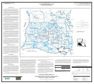
conducted in a set <strong>of</strong> areas called study units. The Acadian-Pontchartrain<br />
(ACAD) is one such Study Unit, <strong>and</strong><br />
consists <strong>of</strong> all or parts <strong>of</strong> 39 parishes in southern Louisiana<br />
<strong>and</strong> 5 counties in southwestern Mississippi (Demas<br />
<strong>and</strong> others, 1999). The 26,000-mi 2 ACAD Study Unit<br />
includes the Mermentau River Basin, a distinctive agricultural<br />
area in southwestern Louisiana. Water-<strong>quality</strong><br />
<strong>and</strong> <strong>ecological</strong> data are needed to describe interactions<br />
between ground- <strong>and</strong> surface-<strong>water</strong> components <strong>of</strong> the<br />
hydrologic cycle <strong>and</strong> to determine the effects <strong>of</strong> agricultural<br />
l<strong>and</strong> use on <strong>water</strong> <strong>quality</strong> in the Mermentau River<br />
Basin.<br />
Purpose <strong>and</strong> Scope<br />
This report characterizes ground-<strong>water</strong> <strong>and</strong> surface<strong>water</strong><br />
<strong>quality</strong> <strong>and</strong> <strong>ecological</strong> <strong>indicators</strong> (aquatic invertebrate<br />
communities <strong>and</strong> habitat conditions) for selected<br />
sites in the Mermentau River Basin. Bed-sediment <strong>quality</strong><br />
also is characterized at selected sites. The <strong>environmental</strong><br />
<strong>setting</strong>, including agricultural, industrial, <strong>water</strong>availability<br />
<strong>and</strong> use, <strong>and</strong> hydrologic characteristics <strong>of</strong> the<br />
Mermentau River Basin are described. This report (1)<br />
describes the occurrence <strong>and</strong> distribution <strong>of</strong> selected<br />
nutrients, major inorganic ions, trace elements, <strong>and</strong> pesticides<br />
in ground <strong>water</strong> <strong>and</strong> surface <strong>water</strong>, suspended sed-