

Maps of the lowland river Sava
Maps of the lowland river Sava
Maps of the lowland river Sava

Create successful ePaper yourself
Turn your PDF publications into a flip-book with our unique Google optimized e-Paper software.
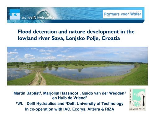
Martin Baptist 1 , Marjolijn Haasnoot 1 , Guido van der Wedden 2<br />
en Huib de Vriend 2<br />
1 WL | Delft Hydraulics and 2 Delft University <strong>of</strong> Technology<br />
In co-operation with IAC, Ecorys, Alterra & RIZA
• Detention areas temporarily store water during floods, to alleviate<br />
flood risks downstream.<br />
• To work effectively, large areas are needed, preferably embanked and<br />
equipped with inlet and outlet structures (sluices).<br />
• Flood detention areas are considered along many European <strong>river</strong>s.<br />
• Flood management in <strong>the</strong> Central <strong>Sava</strong> Basin in Croatia is (already)<br />
largely controlled by flood detention areas.<br />
• In this study, <strong>the</strong> hydrological and ecological functioning <strong>of</strong> one <strong>of</strong><br />
<strong>the</strong>se detention areas, Lonjsko Polje, is studied to give advise on<br />
optimal ecological flood management and to learn from this existing<br />
situation.
Intake <strong>of</strong> <strong>the</strong><br />
SOS canal<br />
Odransko<br />
Polje<br />
1972: Trebež II<br />
outlet sluice<br />
Prevlaka inlet sluice<br />
Cesma <strong>river</strong><br />
1972 UN plan:<br />
Palanjek inlet<br />
weir<br />
Trebež I<br />
outlet sluice<br />
Dike
3650 1:100 year flood event<br />
(m3 2650<br />
/s)<br />
1000<br />
Est. storage capacity<br />
Present: 634·10 6 m 3<br />
1972 plan: 915·10 6 m 3<br />
A World Bank study concluded that<br />
for <strong>the</strong> 1972 plan <strong>the</strong> water levels <strong>of</strong><br />
floods will rise, <strong>the</strong> flood duration<br />
will double and <strong>the</strong>re will be more<br />
<strong>of</strong>ten high waters.<br />
max 600 in<br />
max 2370 in<br />
max 500 out + 250 out
• Main objective: Setting-up guidelines for <strong>the</strong> flood management <strong>of</strong><br />
<strong>the</strong> Lonjsko Polje area to combine (1) flood protection, (2) ecosystem<br />
development and (3) nutrient sink capacity. Compare different<br />
flooding scenarios.<br />
Expected results:<br />
• <strong>Maps</strong> <strong>of</strong> flood inundation depths, flood duration and time for<br />
evacuation for different flood events. Important for park<br />
management.<br />
• Assessment <strong>of</strong> <strong>the</strong> vegetation growth and succession for different<br />
flooding scenarios.<br />
• (Assessment <strong>of</strong> <strong>the</strong> nutrient trapping efficiency <strong>of</strong> Lonjsko Polje,<br />
important for <strong>the</strong> <strong>Sava</strong> nutrient load and subsequently <strong>the</strong> Danube<br />
load.)
• Hydrology: model <strong>the</strong><br />
flooding <strong>of</strong> Lonjsko Polje with<br />
<strong>the</strong> SOBEK overland flow<br />
module.<br />
• Ecology: assess <strong>the</strong><br />
vegetation structure and<br />
succession, related to<br />
flooding.<br />
• (Nutrients: assess <strong>the</strong><br />
nutrient balans <strong>of</strong> <strong>the</strong> Lonjsko<br />
Polje area by coupling <strong>the</strong><br />
flow model to a water quality<br />
model.)
Physical state<br />
Hydrology<br />
Present situation<br />
1972 plan with<br />
additional weir and<br />
sluice<br />
Mean year, 1997<br />
1: 100 year flood
• Peak discharge 3650 m 3 /s
!<br />
"#$!%<br />
!
& '<br />
• Contrary to <strong>the</strong> expectation,<br />
<strong>the</strong> flood duration for <strong>the</strong><br />
1972 plan is shorter than for<br />
<strong>the</strong> present situation.<br />
• This is due to <strong>the</strong> fact that<br />
water can leave Lonjsko Polje<br />
more easily via <strong>the</strong> new<br />
Trebež II sluice and Palanjek<br />
weir, as soon as <strong>the</strong> flood<br />
wave has past by.<br />
• Calculated storage capacity:<br />
Present: 613·10 6 m 3<br />
1972 plan: 845·10 6 m 3
Ecohydrological<br />
assessment<br />
SOBEK Vegetation map<br />
from <strong>the</strong> Park Service<br />
Flood duration<br />
- growing season<br />
- remaining part <strong>of</strong> year<br />
Knowledge rules<br />
give ecotopes after x years,<br />
based on flood duration,<br />
vegetation succession and<br />
management<br />
ecotope maps<br />
after x years<br />
Ecotope map
( ' '<br />
Flood event knowledge rules Season inundation (days) Succession in years<br />
Ecotope code site factor flooding Nov-Mar Apr-Jun 2 10 20 50 100<br />
dry hardwood forest 101 dry < 20 d/yr 20 10 301 201 201 101 101<br />
hardwood forest 102 dry-moist 20 - 50 d/yr 50 20 301 201 201 102 102<br />
aspen plantation 601 moist 50-100 d/yr 100 20 301 201 201 102 102<br />
s<strong>of</strong>twood forest 103 moist 50 - 150 d/yr 120 90 302 202 104 104 105<br />
wet hardwood forest 105 moist-wet 50 - 150 d/yr 120 90 302 202 104 104 105<br />
wet s<strong>of</strong>twood forest 104 wet 50 - 150 d/yr 120 90 302 202 104 104 105<br />
marsh forest 106 wet > 150 d/yr 120 90 303 303 106 106 106<br />
hardwood shrub 201 moist-wet < 50 d/yr 50 20 301 201 201 102 102<br />
s<strong>of</strong>twood shrub 202 wet 50 - 150 d/yr 120 90 302 202 104 104 105<br />
herbaceaous rough 301 dry < 20 d/yr 20 10 301 201 201 101 101<br />
wet herbaceous rough 302 moist > 50 120 50 302 202 104 104 105<br />
herbaceous swamp 303 wet > 150 d/yr 120 50 303 303 106 106 106<br />
reed swamp 304 wet-water 365 d/yr 120 30 701 304 304 304 304<br />
moist meadow 502 moist 20 - 50 d/yr 50 20 301 201 201 102 102<br />
floodplain hayfield 401 moist 20 - 50 d/yr 50 20 301 201 201 102 102<br />
wet hayfield 402 wet 50 - 150 d/yr 120 50 301 202 104 104 105<br />
wet meadow 503 wet 50 - 150 d/yr 120 50 302 202 104 104 105<br />
wet natural pasture 504 wet 50 - 150 d/yr 120 50 302 202 104 104 105<br />
wet grassland 505 wet > 150 d/yr 120 50 302 302 106 106 106<br />
meadows and agriculture 501 < 20 d/yr 20 10 301 201 201 101 101<br />
arable floodplain moist 20 - 50 d/yr 50 20 301 201 201 102 102
Physical state<br />
Hydrology<br />
Current situation<br />
1972 plan with<br />
additional weirs and<br />
sluices<br />
Mean year, 1997<br />
1: 100 year flood
& '<br />
• The effects <strong>of</strong> a 1:100 year flood event differ mainly along<br />
<strong>the</strong> borders <strong>of</strong> <strong>the</strong> central Lonjsko Polje region. Contrary to<br />
<strong>the</strong> expectation, <strong>the</strong> 1972 plan is favourable. The shorter<br />
flood duration leads to less severe effects.<br />
• The mean, autonomous succession differs as well for both<br />
scenarios. However, results show that nature management<br />
is a more important factor for vegetation succession than<br />
flood duration.
• A 1:100 year flood event will inundate <strong>the</strong> entire Lonjsko<br />
Polje within two weeks time, <strong>the</strong>refore all lifestock has to be<br />
evacuated in time.<br />
• The flood duration time <strong>of</strong> floods in Lonjsko Polje is not<br />
determined by <strong>the</strong> amount <strong>of</strong> water that goes in, but by <strong>the</strong><br />
amount <strong>of</strong> water that can go out.<br />
• The ecological effects <strong>of</strong> a flood event are large,<br />
irrespective <strong>of</strong> <strong>the</strong> execution <strong>of</strong> <strong>the</strong> 1972 plan.<br />
• It is recommended to consider an in- and outlet structure<br />
that can take in water during dry summer periods and can<br />
discharge water to drain <strong>the</strong> filled detention area faster.


![CynefinFramework final [Read-Only]](https://img.yumpu.com/19017304/1/190x135/cynefinframework-final-read-only.jpg?quality=85)