

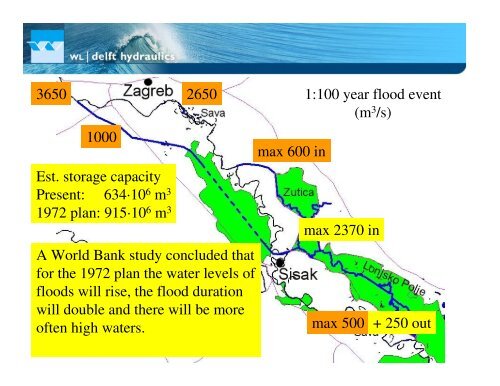
Maps of the lowland river Sava
Maps of the lowland river Sava
Maps of the lowland river Sava

You also want an ePaper? Increase the reach of your titles
YUMPU automatically turns print PDFs into web optimized ePapers that Google loves.
3650 1:100 year flood event<br />
(m3 2650<br />
/s)<br />
1000<br />
Est. storage capacity<br />
Present: 634·10 6 m 3<br />
1972 plan: 915·10 6 m 3<br />
A World Bank study concluded that<br />
for <strong>the</strong> 1972 plan <strong>the</strong> water levels <strong>of</strong><br />
floods will rise, <strong>the</strong> flood duration<br />
will double and <strong>the</strong>re will be more<br />
<strong>of</strong>ten high waters.<br />
max 600 in<br />
max 2370 in<br />
max 500 out + 250 out


![CynefinFramework final [Read-Only]](https://img.yumpu.com/19017304/1/190x135/cynefinframework-final-read-only.jpg?quality=85)