

Co-ordinates
Co-ordinates
Co-ordinates

You also want an ePaper? Increase the reach of your titles
YUMPU automatically turns print PDFs into web optimized ePapers that Google loves.
modules to get all the available receiver<br />
parameters and raw measurements, in<br />
addition to conventional positioning<br />
information. Such data are displayed in<br />
real time on a graphical user interface in<br />
order to easily monitor satellites, signals,<br />
receiver and user’s position. The same<br />
data are also logged with the related GPS<br />
time stamp and stored in different file<br />
formats (ASCII text files, MATLAB®,<br />
Microsoft Office Excel®, binary, RINEX<br />
2/3, KML and NMEA) for easy postprocessing<br />
and analysis purposes.<br />
Such tool provides the possibility to<br />
have a common interface towards<br />
different GNSS receivers in order to<br />
perform measurements and detailed<br />
analysis on a common set of data.<br />
In particular considering the DGPS<br />
technique, it is possible to get the<br />
differential corrections as computed<br />
by the base receiver through different<br />
ways of connection (via COM, GPRS<br />
or TCP). Furthermore in case of<br />
TCP connection SAT-SURF is able<br />
to connect to a Networked Transport<br />
of RTCM via Internet Protocol<br />
(NTRIP) caster to obtain the required<br />
corrections and store all the parameters<br />
according to the RTCM standard.<br />
SAT-SURF is equipped with a GSM<br />
module in order to provide AGPS<br />
functionalities as well. The connection<br />
to the Assistance Server can be set via<br />
TCP or via GPRS by using the GPRS<br />
modem integrated within SAT-SURF.<br />
All the communication sessions between<br />
the two terminals (Assistance Server<br />
of the Base Station and SAT-SURF)<br />
are based on OMA-SUPL protocol.<br />
Recently SAT-SURFER allows the user to<br />
collect data from three different external<br />
Inertial Measurement Units (Microstrain<br />
3DM-GX2, Microstrain 3DM-GX3, and<br />
Crossbow IMU.). An Inertial Unit is able<br />
(a)<br />
to measure accelerations and angular<br />
rates of the system that is monitoring.<br />
The supported IMUs implement<br />
three axes accelerometers, three axes<br />
gyroscopes and, only on the Microstrain<br />
models three axes magnetometers.<br />
<strong>Co</strong>llected data are tagged using the<br />
IMU internal clock, synchronized with<br />
GPS (when it is required) and stored<br />
in MS Excel, Matlab or text files.<br />
The core of the SAT-SURFER is<br />
realized in managed C++ based on<br />
.NET 2.0 and is able to control all the<br />
other software modules, including the<br />
data logging functionalities and several<br />
drivers for each GPS receiver, for the<br />
GSM modem and for other advanced<br />
functionalities (e.g. AGPS, NTRIP<br />
DGPS, SISNeT, etc.). Each driver is<br />
written in native C++ (unmanaged)<br />
allowing to a low level control of<br />
the connected hardware modules.<br />
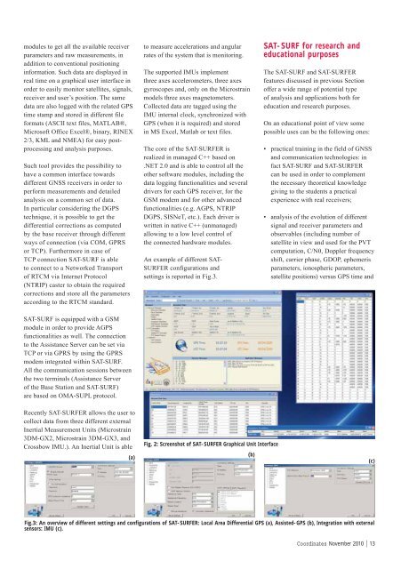
An example of different SAT-<br />
SURFER configurations and<br />
settings is reported in Fig.3.<br />
Fig. 2: Screenshot of SAT-SURFER Graphical Unit Interface<br />
SAT-SURF for research and<br />
educational purposes<br />
The SAT-SURF and SAT-SURFER<br />
features discussed in previous Section<br />
offer a wide range of potential type<br />
of analysis and applications both for<br />
education and research purposes.<br />
On an educational point of view some<br />
possible uses can be the following ones:<br />
• practical training in the field of GNSS<br />
and communication technologies: in<br />
fact SAT-SURF and SAT-SURFER<br />
can be used in order to complement<br />
the necessary theoretical knowledge<br />
giving to the students a practical<br />
experience with real receivers;<br />
• analysis of the evolution of different<br />
signal and receiver parameters and<br />
observables (including number of<br />
satellite in view and used for the PVT<br />
computation, C/N0, Doppler frequency<br />
shift, carrier phase, GDOP, ephemeris<br />
parameters, ionospheric parameters,<br />
satellite positions) versus GPS time and<br />
Fig.3: An overview of different settings and confi gurations of SAT-SURFER: Local Area Differential GPS (a), Assisted-GPS (b), Integration with external<br />
sensors: IMU (c).<br />
(b)<br />
(c)<br />
<strong>Co</strong><strong>ordinates</strong> November 2010 | 13


