

Co-ordinates
Co-ordinates
Co-ordinates

Create successful ePaper yourself
Turn your PDF publications into a flip-book with our unique Google optimized e-Paper software.
in different environmental conditions<br />
(e.g. outdoor vs light-indoor);<br />
• implementation and performance<br />
validation of PVT computation<br />
strategies using raw pseudorange<br />
measurements and reliable comparison<br />
of positioning performances.<br />
At the same time, SAT-SURF represents<br />
a valid and effective instrument to be<br />
used by researchers which can give<br />
the possibility to store a huge amount<br />
of raw data and satellite parameters as<br />
well as to simplify the analysis in postprocessing.<br />
At the time of writing SAT-<br />
SURF has been successfully exploited<br />
in several research experiments. The<br />
most remarkable ones are cited in<br />
the following part of the section:<br />
• Since there is not a clear-cut answer<br />
on the corrections update rate effect,<br />
the aforementioned device has been<br />
used to investigate how the time<br />
interval between a correction set and<br />
the following affects the positioning.<br />
Several tests both in static and dynamic<br />
mode have been run 2-4 hours long<br />
in different times of the day order<br />
to have exhaustive results [3]. For<br />
each of these trials four SAT-SURFs<br />
running in parallel were used and set<br />
to receive DGPS corrections with<br />
rates of 1, 15, 30 and 59 seconds.<br />
Results are plotted in Fig.5.<br />
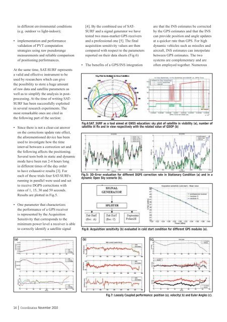
• One parameter that characterizes<br />
the performance of a GPS receiver<br />
is represented by the Acquisition<br />
Sensitivity that corresponds to the<br />
minimum power level a receiver is able<br />
to correctly identify a satellite signal<br />
14 | <strong>Co</strong><strong>ordinates</strong> November 2010<br />
[4]. By the combined use of SAT-<br />
SURF and a signal generator we have<br />
tested two mass-market GPS receivers<br />
and a professional one [5]. The final<br />
acquisition sensitivity values are then<br />
compared with respect to the parameters<br />
reported on their data sheets (Fig.6)<br />
• The benefits of a GPS/INS integration<br />
are that the INS estimates be corrected<br />
by the GPS estimates and that the INS<br />
can provide position and angle updates<br />
at a quicker rate than GPS. For high<br />
dynamic vehicles such as missiles and<br />
aircraft, INS estimates can interpolate<br />
between GPS estimates. The two<br />
systems are complementary and are<br />
often employed together. Numerous<br />
Fig.4:SAT_SURF as a tool aimed at GNSS education: sky plot of satellite in visibility (a), number of<br />
satellite in fi x and in view respectively with the related value of GDOP (b)<br />
Fig.5: 3D-Error evaluation for different DGPS correction rate in Stationary <strong>Co</strong>ndition (a) and in a<br />
dynamic Open Sky scenario (b).<br />
Fig.6: Acquisition sensitivity (b) evaluated in cold start condition for different GPS modules (a).<br />
(a) (b)<br />
(c)<br />
Fig.7: Loosely <strong>Co</strong>upled performance: position (a), velocity( b) and Euler Angles (c).


