

Co-ordinates
Co-ordinates
Co-ordinates

Create successful ePaper yourself
Turn your PDF publications into a flip-book with our unique Google optimized e-Paper software.
approaches are possible for the<br />
integration of GPS and INS estimates<br />
to provide a combined navigation<br />
solution. Differences between the<br />
various approaches are based on the<br />
type of information that is shared<br />
between the individual systems.<br />
There are two main categories of<br />
integration approaches: loosely<br />
coupled (LC) and tightly coupled<br />
(TC). The first method uses GPS<br />
position and velocity measurements in<br />
a Kalman filter that models INS error<br />
dynamics. The second (?) approach<br />
uses GPS estimates of Pseudoranges<br />
and Doppler (determined by using<br />
satellite ephemeris data) and inertial<br />
estimates within a Kalman filter. By<br />
the use of SAT-SURF that collects<br />
raw IMU data synchronized with the<br />
GPS a loosely and tightly performance<br />
has been investigated. In Fig.7 an<br />
example of loosely coupled GPS/<br />
INS integration is shown [6].<br />
• The integration of navigation and<br />
communication functionalities is<br />
one of the key elements exploited<br />
in new location-based systems and<br />
services. The Assisted-GNSS is a<br />
strategy based on such integration<br />
delivering through the COM<br />
channel assistance parameters[7].<br />
The most recent architecture for<br />
the interchange of GPS assistance<br />
data is the so called OMA-SUPL<br />
[8] (Open Mobile Alliance – Secure<br />
User Plane Location). Specific tests<br />
in the field of Assisted-GPS proved<br />
the capabilities and flexibility of the<br />
tool highlighting interesting features<br />
in the use of aiding over embedded<br />
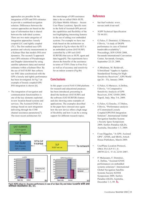
systems. For example we have run<br />
trials based on the architecture as<br />
depicted in Fig.8a where the SET is<br />
an embedded system (SAT-SURF)<br />
controlled by a SW tool (SAT-<br />
SURFER) that acts as SUPL agent and<br />
data logger[9]. The experiments have<br />
shown the benefits of the assistance<br />
in terms of TTFF (Time to First Fix)<br />
as well as of accuracy and sensitivity<br />
for an indoor scenario (Fig.8b)<br />
<strong>Co</strong>nclusions<br />
In this paper a novel NAV/COM platform<br />
for research and educational purposes<br />
has been introduced, presenting in<br />
detail the hardware (SAT-SURF) and<br />
the software (SAT-SURFER) feature<br />
and also showing some examples of<br />
applications. The examples described<br />
in the paper have stressed once again<br />
how the new device offers a high range<br />
of flexibility and how it can be a strong<br />
support for different research topics.<br />
(b)<br />
(c)<br />
Fig.8: AGPS setup (a), Accuracy performance in case of an Open Sky and Indoor Scenario with and<br />
without Assistance (b), (c).<br />
(a)<br />
Reference<br />
• Sat-Surf website: www.<br />
navsas.ismb.it/sat-surf.<br />
• 3GPP Technical Specification<br />
TS 44.031.<br />
• G.Falco, F. Dominici, G.Marucco,<br />
F.Dovis, “A study of DGPS<br />
performance in case of limited<br />
bandwidth availability”,<br />
Proceedings, ION GNSS 2008,<br />
Savannah International <strong>Co</strong>nvention<br />
Center, Savannah, Georgia,<br />
September 22-25, 2009.<br />
• A.Mitelman, M. Reidevall,<br />
S.Strickland “Apples to Apples-<br />
Standardized Testing for High-<br />
Sensitivity Receivers”, GPS World<br />
(pp 26 - 33), January 2008.<br />
• G.Falco, G.Marucco, A.Defina,<br />
F.Dovis, “A <strong>Co</strong>mparative<br />
Sensitivity Analysis of GPS<br />
Receivers, ENC GNSS 2009,<br />
Napoli, Italy, May 3-6, 2009.<br />
• G.Falco, G.Einecke, J.T.Malos,<br />
F.Dovis, “Performance analysis<br />
of <strong>Co</strong>nstrained Loosely<br />
<strong>Co</strong>upled GPS/INS Integration<br />
Solution”, International Global<br />
Navigation Satellite System<br />
s Society Ignss Symposium<br />
2009, Surfers Paradise (QLD),<br />
Australia, December 1-3, 2009.<br />
• F.van Diggelen, “A-GPS: Assisted<br />
GPS”, GNSS, and SBAS, Artech<br />
House Publishers, March 2009.<br />
• UserPlane Location Protocol,<br />
OMA-TS-ULP-V1_0-<br />
20070122-C, V1.0, 22/01/2007.<br />
• P. Mulassano, F. Dominici,<br />
A. Defina, “Assisted-GNSS<br />
performances on embedded<br />
systems solutions”, International<br />
Global Navigation Satellite<br />
Systems Society IGNSS<br />
Symposium 2009, Surfers<br />
Paradise (QLD), Australia,<br />
December 1-3, 09.<br />
<strong>Co</strong><strong>ordinates</strong> November 2010 | 15


