Burbage Info Sheet.pdf
Burbage Info Sheet.pdf
Burbage Info Sheet.pdf

You also want an ePaper? Increase the reach of your titles
YUMPU automatically turns print PDFs into web optimized ePapers that Google loves.
13/10/2009 Peak District National Park: Study Area<br />
Geology<br />
Prehistoric Settlement<br />
Carl Wark<br />
The landscape in the burbage valley<br />
Routeways<br />
Land Use In The Valley<br />
Land Use Today<br />
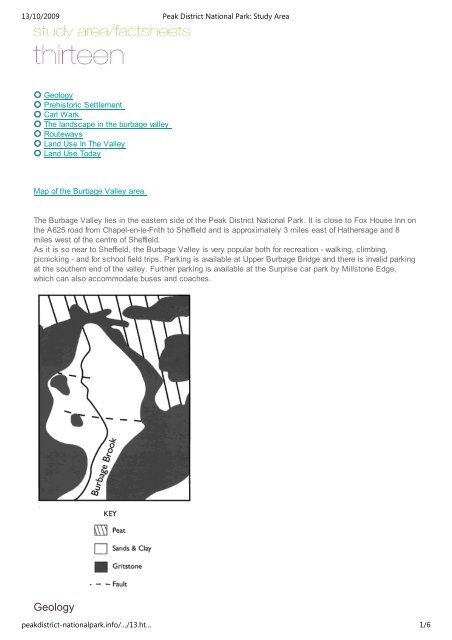
Map of the <strong>Burbage</strong> Valley area<br />
The <strong>Burbage</strong> Valley lies in the eastern side of the Peak District National Park. It is close to Fox House Inn on<br />
the A625 road from Chapel-en-le-Frith to Sheffield and is approximately 3 miles east of Hathersage and 8<br />
miles west of the centre of Sheffield.<br />
As it is so near to Sheffield, the <strong>Burbage</strong> Valley is very popular both for recreation - walking, climbing,<br />
picnicking - and for school field trips. Parking is available at Upper <strong>Burbage</strong> Bridge and there is invalid parking<br />
at the southern end of the valley. Further parking is available at the Surprise car park by Millstone Edge,<br />
which can also accommodate buses and coaches.<br />
Geology<br />
peakdistrict-nationalpark.info/…/13.ht… 1/6
13/10/2009 Peak District National Park: Study Area<br />
The <strong>Burbage</strong> Valley is a basin partly surrounded by scarps or edges of gritstone: <strong>Burbage</strong> Rocks on the east<br />
and Higger Tor and Carl Wark on the west. The gritstone is resistant to erosion.<br />
The shale valley basin is partly filled with an overlying deposit known as head. This is a deposit which is a<br />
mixture of sands and clay and it is thought to have been brought by ice sheets during the Ice-Age.<br />
East of <strong>Burbage</strong> Rocks is <strong>Burbage</strong> Moor, an extensive plateau partly covered by peat. This consists of<br />
partially decomposed vegetation which accumulated in water-logged conditions during periods when the<br />
climate was cool and wet.<br />
Back to top<br />
- - - - - - - - - - - - - - - - - -<br />
Prehistoric Settlement<br />
The first evidence of human activity comes from flints left behind by groups of hunter-gatherers who travelled<br />
through the area. Early evidence of occupation occurs south of Carl Wark and dates from the Bronze Age<br />
(circa 1500 BC). It is marked by small clearance cairns formed out of stones cleared from the area by the<br />
early farmers. These cairns are now covered by vegetation which makes them difficult to find.<br />
Carl Wark<br />
Back to top<br />
- - - - - - - - - - - - - - - - - -<br />
Carl Wark<br />
The defended promontory fort of Carl Wark, which is a Scheduled Ancient Monument, probably dates from the<br />
Iron Age. It may have been used as a refuge when the local inhabitants were under threat. The earthen<br />
rampart and stone wall, built to defend the one acre site, can still be seen on the western side of the fort.<br />
Back to top<br />
- - - - - - - - - - - - - - - - - -<br />
The landscape in the burbage valley<br />
<strong>Burbage</strong> Brook<br />
The <strong>Burbage</strong> Brook rises in the moorland north of the <strong>Burbage</strong> Valley and enters the valley under the Upper<br />
<strong>Burbage</strong> Bridge. From here the height of the stream quickly drops from just over 396m down to 335m in less<br />
than 1 km. The Brook therefore provides a good area for hydrological work. Hypotheses showing the different<br />
water velocities along the Brook and the differences in the size of contents of the stream bed, can easily be<br />
tested.<br />
peakdistrict-nationalpark.info/…/13.ht… 2/6
13/10/2009 Peak District National Park: Study Area<br />
Aerial view of Millstone Edge<br />
Forest Areas<br />
The 83 acre plantation was planted between 1968 and 1971. The trees are mainly Scots Pine, Japanese<br />
Larch and Lodgepole Pine. Some deciduous species were planted around the edges of the plantation to<br />
soften its outline.<br />
Bird species which are regularly seen in the plantation are jays, rooks and chaffinches.<br />
Ecology<br />
The Dark Peak moorland, such as that on <strong>Burbage</strong> Moor, is the nearest thing to wilderness in England. The<br />
moorland and blanket bog terrain found here are rare and valuable habitats which support a unique fauna.<br />
<strong>Burbage</strong> Moor lies around 400 metres above sea level and experiences low temperatures, high rainfall, is<br />
exposed and windy. Plants and animals need to be hardy and highly adapted to live on the moorland,<br />
because of the extreme climate and acid soils. High rainfall carries the few minerals downwards where many<br />
plants cannot reach them.<br />
Heather, cowberry, bilberry and moorland grasses, are found on the gritstone areas. The shale and head<br />
deposits in the valley are more fertile, enabling more vigorous grasses and bracken to grow. Because of the<br />
lack of competition from other plants, bracken has started to dominate the vegetation in these areas. Efforts<br />
have been made to limit this domination by cutting back and controlling the bracken.<br />
peakdistrict-nationalpark.info/…/13.ht… 3/6
13/10/2009 Peak District National Park: Study Area<br />
Moorland birds like wheatears and meadow pipits can be seen during spring to autumn. Skylarks can also be<br />
heard in spring. The elusive mountain hare and the red grouse are able to survive all winter on the moors.<br />
<strong>Burbage</strong> Brook is home to dippers and grey wagtails throughout the year<br />
Back to top<br />
- - - - - - - - - - - - - - - - - -<br />
Routeways<br />
Packhorse Routes<br />
Routeways through the <strong>Burbage</strong> area may have been in existence for thousands of years. However, the hollow<br />
ways and the pack horse bridge, which can be seen below Carl Wark, are mostly from the Medieval Period.<br />
One pack horse route crossed Millstone Edge and forded the <strong>Burbage</strong> Brook to the south of the more recent<br />
A625.<br />
The pack horse trains could consist of up to 50 horses all carrying goods through the landscape.<br />
Turnpike Roads<br />
The roads which now surround <strong>Burbage</strong> Moor were first built as turnpike roads, though many of the routes<br />
may have followed existing trackways. The owners of these roads were able to charge a toll to people using<br />
the route. This funding enabled the roads to be maintained to a higher standard than the normal roads and<br />
therefore movement of goods and people along them was quicker.<br />
The Houndkirk road was built in 1758 and was never surfaced with modern materials. It is therefore an exellent<br />
example of a turnpike road. Another road built at this time crosses over the Upper <strong>Burbage</strong> Bridge and<br />
continues into Ringinglow. Part of the main A625 road, which crosses the bottom of the valley area was built<br />
in 1781.<br />
Back to top<br />
- - - - - - - - - - - - - - - - - -<br />
Land Use In The Valley<br />
Quarrying and the Millstone Industry<br />
Quarrying in the <strong>Burbage</strong> area probably started over 2000 years ago when millstone grit was used to make<br />
rotary querns. These were the hand-held equivalents of the later millstones.<br />
peakdistrict-nationalpark.info/…/13.ht… 4/6
13/10/2009 Peak District National Park: Study Area<br />
Millstones<br />
During the 18th and 19th centuries Wild Moorstones Edge Quarry manufactured millstones, grindstones (for<br />
the Sheffield edge-tool industry) and other stone products. The sizes and shapes of the millstones varied<br />
through time. The earlier were dome-shaped on top whilst the later ones were flat on both sides. The average<br />
size was approximately 5 feet in diameter and over a ton in weight.<br />
The millstones were made at the quarry site and transported all over Britain and even abroad. Discarded<br />
millstones can still be seen at the quarry sites in the <strong>Burbage</strong> Valley and also at other quarries in the Peak<br />
District.<br />
Land Ownership<br />
Since 1928 the <strong>Burbage</strong> Valley has been owned by Sheffield City Council, who bought it from the Duke of<br />
Rutland, with the idea of building a reservoir in the area. Due to local opposition to this proposed reservoir, the<br />
project was cancelled but Sheffield Council continued to manage the land, which is now tenanted out to a<br />
local sheep farmer.<br />
The rights to use the valley for grouse shooting and other sporting activities were leased out by the council<br />
until 1936. This limited public access to the land. After 1936 new paths were gradually opened up and public<br />
access was extended in to the valley. A new access agreement has recently been completed.<br />
Back to top<br />
- - - - - - - - - - - - - - - - - -<br />
Land Use Today<br />
Farming<br />
Higger Tor<br />
The area is classed by the Ministry of Agriculture as Grade 5 land which means the land is very poor farming<br />
land. Grants are available from the Government to help the farming community. Only a small number of sheep<br />
can be kept on the moors, as overgrazing has a serious effect on the vegetation, which cannot regenerate<br />
peakdistrict-nationalpark.info/…/13.ht… 5/6
13/10/2009 Peak District National Park: Study Area<br />
quickly due to the difficult growing conditions. Overgrazing also allows invasive species like bracken to<br />
encroach onto the moors.<br />
It is likely that much of the area was once covered with trees. Bronze Age and Iron Age farmers cleared the<br />
trees to grow crops and centuries of sheep grazing have prevented their regrowth. The natural moorland is in<br />
fact a man-made environment.<br />
Recreation<br />
The closeness of the <strong>Burbage</strong> Valley to major towns has led to its popularity with a wide range of people. The<br />
many tracks and paths through the valley have encouraged walkers into the area and rock climbers can be<br />
seen on many days throughout the year taking advantage of the climbing routes available on <strong>Burbage</strong> Edge.<br />
Another sport popular with many youth groups is that of weaseling and this involves scrambling around some<br />
of the large gritstone blocks on Higger Tor.<br />
Management of the Moors<br />
When the moors had shooting rights let out on them, they were specifically managed to encourage the<br />
grouse. This involved the burning of small patches of heather in rotation during the winter to encourage new<br />
growth. Recently, controlled burning has taken place to encourage regrowth of heather, creating habitats for<br />
wildlife and food for sheep. Uncontrolled summer fires can cause a lot of damage to vegetation and to<br />
creatures. An area devastated by fire in 1976 is still mainly bare peat and (where the peat has burnt away)<br />
bare gritstone.<br />
Further management problems come from the erosion of footpaths by walkers and increasingly by mountain<br />
bikes. Footpaths around Higger Tor are being repaired and re-surfaced by the Peak District Rangers to keep<br />
erosion to a minimum.<br />
Back to top<br />
peakdistrict-nationalpark.info/…/13.ht… 6/6