

Hawkesbury-Nepean River Environmental Monitoring Program
Hawkesbury-Nepean River Environmental Monitoring Program
Hawkesbury-Nepean River Environmental Monitoring Program

You also want an ePaper? Increase the reach of your titles
YUMPU automatically turns print PDFs into web optimized ePapers that Google loves.
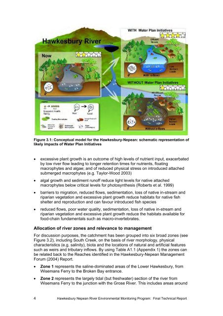
Figure 3.1: Conceptual model for the <strong>Hawkesbury</strong>-<strong>Nepean</strong>: schematic representation of<br />
likely impacts of Water Plan Initiatives<br />
• excessive plant growth is an outcome of high levels of nutrient input, exacerbated<br />
by low river flow leading to longer retention times for nutrients, floating<br />
macrophytes and algae; and of reduced physical stress on introduced attached<br />
submerged macrophytes (e.g. Taylor-Wood 2003)<br />
• algal growth and sediment runoff reduce light levels for native attached<br />
macrophytes below critical levels for photosynthesis (Roberts et al. 1999)<br />
• barriers to migration, reduced flows, sedimentation, loss of native in-stream and<br />
riparian vegetation and excessive plant growth reduce habitats for native fish<br />
shelter and reproduction and can favour introduced fish species<br />
• reduced flows, poor water quality, sedimentation, loss of native in-stream and<br />
riparian vegetation and excessive plant growth reduce the habitats available for<br />
food-chain fundamentals such as macro-invertebrates.<br />
Allocation of river zones and relevance to management<br />
For discussion purposes, the catchment has been grouped into six broad zones (see<br />
Figure 3.2), including South Creek, on the basis of river morphology, physical<br />
characteristics (e.g. salinity), biota and the locations of natural and artificial features<br />
such as weirs and tributary inflows. By using Table A1.1 (Appendix 1) the zones can<br />
be related back to the Reaches identified in the <strong>Hawkesbury</strong>-<strong>Nepean</strong> Management<br />
Forum (2004) Report.<br />
• Zone 1 represents the saline-dominated areas of the Lower <strong>Hawkesbury</strong>, from<br />
Wisemans Ferry to the Broken Bay entrance.<br />
• Zone 2 represents the largely tidal (but freshwater) section of the river from<br />
Wisemans Ferry to the junction with the Grose <strong>River</strong>. This includes areas around<br />
4 <strong>Hawkesbury</strong> <strong>Nepean</strong> <strong>River</strong> <strong>Environmental</strong> <strong>Monitoring</strong> <strong>Program</strong>: Final Technical Report


