

Download Rivermeade_VDFP - pdf - Fingal County Council
Download Rivermeade_VDFP - pdf - Fingal County Council
Download Rivermeade_VDFP - pdf - Fingal County Council

Create successful ePaper yourself
Turn your PDF publications into a flip-book with our unique Google optimized e-Paper software.
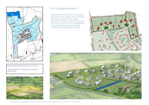
11<br />
Area 11: (3.05 Ha) Potential density: 3.6 units/ Ha<br />
- potential yield of 11 residential units on private<br />
serviced sites<br />
2.81 Development Area 11<br />
Development Areas 10 and 11 are located<br />
within the northern section of the LAP lands<br />
and inside the northern and western<br />
boundaries. Access is proposed via the new<br />
road and river crossing. Circa 18 residential<br />
units are proposed on private serviced<br />
residential sites, arranged in 3 clusters.<br />
<strong>Rivermeade</strong> Village Development Framework Plan iCON Architecture | Urban Design | Conservation, with Cummins and Voortman 35


