

Download Rivermeade_VDFP - pdf - Fingal County Council
Download Rivermeade_VDFP - pdf - Fingal County Council
Download Rivermeade_VDFP - pdf - Fingal County Council

Create successful ePaper yourself
Turn your PDF publications into a flip-book with our unique Google optimized e-Paper software.
The immediate surroundings have particular landscape<br />
quality. The Ward River creates a low-‐lying wetlands<br />
pool beside the bridge, curves around a steeply sloping<br />
northern slope and fills out into the reservoir, a sizable<br />
surface of water and an attractive amenity with great<br />
potential for recreational use. This area has mixed<br />
woodland and mature hedgerow trees, all of which are<br />
close to the houses and help to invest an arcadian<br />
quality in the tradition of garden villages of the early<br />
twentieth century.<br />
The river is also the source of considerable ecological<br />
interest and biodiversity. The water surface is<br />
frequented by wild birds, ducks, swans and wintering<br />
geese, and the associated wetlands appear to contain a<br />
diversity of plants. To have such a natural resource so<br />
close to the village is a benefit at the same time as a<br />
challenge -‐ how to maximise the use of the river,<br />
reservoir and banks for the benefit of the community<br />
without adversely affecting their habitat and<br />
biodiversity?<br />
2<br />
4<br />
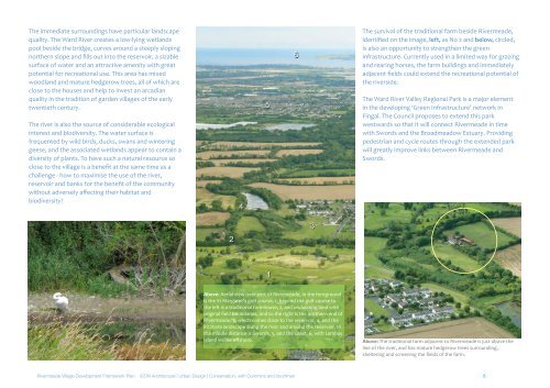
Above: Aerial view over part of <strong>Rivermeade</strong>, In the foreground<br />
is the St Margaret’s golf course, 1, beyond the golf course to<br />
the left is a traditional farmhouse, 2, and undulating land with<br />
original field boundaries, and to the right is the northern end of<br />
<strong>Rivermeade</strong>, 3, which comes close to the reservoir, 4, and the<br />
intimate landscape along the river and around the reservoir. In<br />
the middle distance is Swords, 5, and the coast, 6, with Lambay<br />
Island visible offshore.<br />
The survival of the traditional farm beside <strong>Rivermeade</strong>,<br />
identified on the image, left, as No 2 and below, circled,<br />
is also an opportunity to strengthen the green<br />
infrastructure. Currently used in a limited way for grazing<br />
and rearing horses, the farm buildings and immediately<br />
adjacent fields could extend the recreational potential of<br />
the riverside.<br />
The Ward River Valley Regional Park is a major element<br />
in the developing ‘Green Infrastructure’ network in<br />
<strong>Fingal</strong>. The <strong>Council</strong> proposes to extend this park<br />
westwards so that it will connect <strong>Rivermeade</strong> in time<br />
with Swords and the Broadmeadow Estuary. Providing<br />
pedestrian and cycle routes through the extended park<br />
will greatly improve links between <strong>Rivermeade</strong> and<br />
Swords.<br />
Above: The traditional farm adjacent to <strong>Rivermeade</strong> is just above the<br />
line of the river, and has mature hedgerow trees surrounding,<br />
sheltering and screening the fields of the farm.<br />
<strong>Rivermeade</strong> Village Development Framework Plan iCON Architecture | Urban Design | Conservation, with Cummins and Voortman 6<br />
5<br />
1<br />
6<br />
3


