

Download Rivermeade_VDFP - pdf - Fingal County Council
Download Rivermeade_VDFP - pdf - Fingal County Council
Download Rivermeade_VDFP - pdf - Fingal County Council

You also want an ePaper? Increase the reach of your titles
YUMPU automatically turns print PDFs into web optimized ePapers that Google loves.
<strong>Rivermeade</strong><br />
Village Development Framework Plan and Design Guidance<br />
<strong>Rivermeade</strong> Village Development Framework Plan iCON Architecture | Urban Design | Conservation, with Cummins and Voortman 1
<strong>Rivermeade</strong><br />
Village Development Framework Plan and Design Guidance<br />
The <strong>Rivermeade</strong> Plan was produced between September<br />
2010 and August 2011 by a team of architects and urban<br />
designers, Philip and Delphine Geoghegan of<br />
iCON Architecture | Urban Design | Conservation,<br />
and Bernard Voortman of CUMMINS + VOORTMAN,<br />
Sustainable Architecture & Urban Design.<br />
The steering committee for <strong>Fingal</strong> <strong>County</strong> <strong>Council</strong><br />
Planning Department included Marjorie O’Shee, Patricia<br />
Conlon and Peter Byrne. They compiled and developed<br />
the brief and liaised regularly during production of the<br />
Plan.<br />
telephone: 00 353 (0)404 48206 mobile: 00 353 (0)86 8593264<br />
Ballymurrin House | Kilbride | Wicklow | <strong>County</strong> Wicklow<br />
Philip and Delphine Geoghegan<br />
iCON | Architecture | Urban Design | Conservation<br />
iCON<br />
Architecture<br />
Urban Design<br />
Conservation<br />
This Village Development Framework<br />
Plan and Design Guidance [<strong>VDFP</strong>]<br />
is published with the <strong>Rivermeade</strong> LAP, to<br />
provide guidance for the long term<br />
sustainable development of <strong>Rivermeade</strong>.<br />
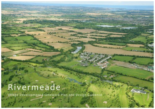
<strong>Rivermeade</strong> from the air; the red line delineates the proposed Local Area Plan (LAP) area, which<br />
incorporates some strong landscape features<br />
<strong>Fingal</strong> <strong>County</strong> <strong>Council</strong> seeks to maintain and strengthen<br />
the physical character of <strong>Rivermeade</strong> village, to guide<br />
village improvements and to plan for appropriate future<br />
growth.<br />
In setting out this guidance, The following key issues are<br />
dealt with:<br />
• Protecting and improving <strong>Rivermeade</strong>’s distinctive<br />
character of place.<br />
• Providing for sustainable growth and consolidation,<br />
with a diverse and flexible housing mix, while<br />
protecting the quality, character and distinctiveness of<br />
important landscape assets.<br />
<strong>Rivermeade</strong> Village Development Framework Plan iCON Architecture | Urban Design | Conservation, with Cummins and Voortman 2
Contents<br />
Section 1<br />
The Context and<br />
Character of<br />
<strong>Rivermeade</strong><br />
Village<br />
1.0 Introduction 5<br />
-‐Location<br />
1.1 Background<br />
1.2 Estate or Village?<br />
1.3 The Airport<br />
1.4 Rural Setting and Landscape Quality 5<br />
1.5 Recreational Facilities 8<br />
1.6 The urban form and built environment of<br />
<strong>Rivermeade</strong> 9<br />
1.7 Economic and Social Context 10<br />
1.8 Movement to and from and in and around<br />
<strong>Rivermeade</strong> 12<br />
Section 2<br />
Key Decisions and<br />
A Vision for the<br />
Future<br />
2.1 The Village needs better accessibility 13<br />
2.2 The Village Needs a Centre 13<br />
2.3 Distinctive Quality of village 15<br />
2.4 A Sustainable Energy Community 17<br />
2.5 <strong>Rivermeade</strong> -‐ The Vision 18<br />
2.6 Environmental improvements within the<br />
village 19<br />
2.7 Development Areas 1 to 11 24<br />
Section 3<br />
<strong>Rivermeade</strong>:<br />
Village Design<br />
Guidance<br />
3.1 Sustainable Design Objectives 40<br />
3.2 General Village Objectives 42<br />
3.3 Residential Design Recommendations 44<br />
3.4 Site Design statement (SDS) 46<br />
<strong>Rivermeade</strong> Village Development Framework Plan iCON Architecture | Urban Design | Conservation, with Cummins and Voortman 3
The reservoir along the River Ward at <strong>Rivermeade</strong> has been disused for a number of years. As a result, nature has taken over; the river meanders through<br />
the partially dried river bed, the trees have grown up and it is now an exclusive world for wildlife, flora and fauna. Sensitive intervention could allow for<br />
controlled public access as part of the Ward River Valley Regional Park. This pencil drawing, depicting the security fence removed and a pathway<br />
substituted, was made by Tina Geoghegan.<br />
<strong>Rivermeade</strong> Village Development Framework Plan iCON Architecture | Urban Design | Conservation, with Cummins and Voortman 4
Section 1<br />
The Context and<br />
Character of<br />
<strong>Rivermeade</strong><br />
Village<br />
1.0 Introduction -‐ Location<br />
<strong>Rivermeade</strong> is located within the rural area of <strong>Fingal</strong> to<br />
the west of Swords and north of Dublin Airport. The<br />
village is about 7 km to the west of Swords, about 3 km<br />
from St. Margaret’s to the south and about 8 Km from<br />
Finglas.<br />
1.1 Background<br />
The settlement of <strong>Rivermeade</strong>/Toberburr was<br />
constructed in the 1970’s by Dublin <strong>County</strong> <strong>Council</strong> as a<br />
social housing estate principally to accommodate<br />
residents in the village of St. Margaret’s who were<br />
displaced as a consequence of the expansion of Dublin<br />
airport. The only development which has occurred since<br />
the estate was built has been the construction of 24<br />
houses and a community facility some years ago.<br />
<strong>Rivermeade</strong> is a well established community and there is<br />
continuing demand from connected families to live<br />
there.<br />
1.2 Estate or Village?<br />
<strong>Rivermeade</strong> was designed as a single housing estate. It<br />
has been extended in a limited way, and has the<br />
character of an isolated housing estate with severely<br />
limited facilities comprising a primary school, a small<br />
shop, a resource centre, playing fields, a playground and<br />
walking routes.<br />
Although it has the character of an estate, it has the<br />
potential to act as a village, if those attributes of a village<br />
could be incorporated into an expanding <strong>Rivermeade</strong>.<br />
This reappraisal of the area is an opportunity to set down<br />
the structure for a sustainable regenerated village.<br />
The achievement of such a transformation over time is a<br />
key objective of this Village Development Framework Plan<br />
1.3 The Airport<br />
Dublin airport, a key employment area in the Dublin<br />
region is located in close proximity to <strong>Rivermeade</strong>.<br />
The majority of the LAP lands are located within the<br />
Outer Airport Noise Zone, while the southern arm of the<br />
LAP lands is also within the Inner Airport Noise Zone<br />
which precludes new residential development.<br />
1.4 Rural Setting and Landscape Quality<br />
<strong>Rivermeade</strong> is located in a rural area, with productive<br />
agricultural land and a large agri-‐business on its<br />
doorstep. Keelings a major food producer and distributor<br />
is located beside <strong>Rivermeade</strong>, south of Killeek Lane. This<br />
area will be a key expanding employment area into the<br />
future.<br />
The LAP lands are located within the designated<br />
ROLLING HILLS CHARACTER TYPE in the <strong>County</strong><br />
Development Plan. These lands are characterised by the<br />
mature vegetation along the Ward River and the strong<br />
vegetative field boundaries. The undulating nature of the<br />
countryside together with trees and river valley help<br />
create a rich landscape both visually and ecologically.<br />
Above: the unspoiled landscape quality of the reservoir is a<br />
consequence of its disuse for some time, allowing vegetation to take<br />
over and creating a true nature sanctuary.<br />
Below: Dublin Airport is close to <strong>Rivermeade</strong>.<br />
Swords town is seen, right of picture, expanding westwards.<br />
The connector which is most evident here is the Ward River -‐ the pale<br />
blue dotted line -‐ links <strong>Rivermeade</strong> to Swords as the river flows<br />
eastwards through the Ward Valley Regional Park to Broadmeadow<br />
Estuary. It could provide an excellent, continuous, greenway for<br />
walking or cycling.<br />
<strong>Rivermeade</strong><br />
Ward River Valley from <strong>Rivermeade</strong> to Swords<br />
<strong>Rivermeade</strong> Village Development Framework Plan iCON Architecture | Urban Design | Conservation, with Cummins and Voortman 5<br />
Airport<br />
Swords
The immediate surroundings have particular landscape<br />
quality. The Ward River creates a low-‐lying wetlands<br />
pool beside the bridge, curves around a steeply sloping<br />
northern slope and fills out into the reservoir, a sizable<br />
surface of water and an attractive amenity with great<br />
potential for recreational use. This area has mixed<br />
woodland and mature hedgerow trees, all of which are<br />
close to the houses and help to invest an arcadian<br />
quality in the tradition of garden villages of the early<br />
twentieth century.<br />
The river is also the source of considerable ecological<br />
interest and biodiversity. The water surface is<br />
frequented by wild birds, ducks, swans and wintering<br />
geese, and the associated wetlands appear to contain a<br />
diversity of plants. To have such a natural resource so<br />
close to the village is a benefit at the same time as a<br />
challenge -‐ how to maximise the use of the river,<br />
reservoir and banks for the benefit of the community<br />
without adversely affecting their habitat and<br />
biodiversity?<br />
2<br />
4<br />
Above: Aerial view over part of <strong>Rivermeade</strong>, In the foreground<br />
is the St Margaret’s golf course, 1, beyond the golf course to<br />
the left is a traditional farmhouse, 2, and undulating land with<br />
original field boundaries, and to the right is the northern end of<br />
<strong>Rivermeade</strong>, 3, which comes close to the reservoir, 4, and the<br />
intimate landscape along the river and around the reservoir. In<br />
the middle distance is Swords, 5, and the coast, 6, with Lambay<br />
Island visible offshore.<br />
The survival of the traditional farm beside <strong>Rivermeade</strong>,<br />
identified on the image, left, as No 2 and below, circled,<br />
is also an opportunity to strengthen the green<br />
infrastructure. Currently used in a limited way for grazing<br />
and rearing horses, the farm buildings and immediately<br />
adjacent fields could extend the recreational potential of<br />
the riverside.<br />
The Ward River Valley Regional Park is a major element<br />
in the developing ‘Green Infrastructure’ network in<br />
<strong>Fingal</strong>. The <strong>Council</strong> proposes to extend this park<br />
westwards so that it will connect <strong>Rivermeade</strong> in time<br />
with Swords and the Broadmeadow Estuary. Providing<br />
pedestrian and cycle routes through the extended park<br />
will greatly improve links between <strong>Rivermeade</strong> and<br />
Swords.<br />
Above: The traditional farm adjacent to <strong>Rivermeade</strong> is just above the<br />
line of the river, and has mature hedgerow trees surrounding,<br />
sheltering and screening the fields of the farm.<br />
<strong>Rivermeade</strong> Village Development Framework Plan iCON Architecture | Urban Design | Conservation, with Cummins and Voortman 6<br />
5<br />
1<br />
6<br />
3
Planning for the long term development of <strong>Rivermeade</strong><br />
is an opportunity to provide for the improvement,<br />
protection, enhancement and extension of existing<br />
Green Infrastructure in an integrated and coherent way<br />
for the benefit of both those living in <strong>Rivermeade</strong> and<br />
those living in the wider catchment area including<br />
Swords. The extension of the Regional Park westwards<br />
from Knocksedan to <strong>Rivermeade</strong> will greatly improve<br />
the amenity potential of the Ward River Valley and<br />
connectivity to Swords which is only 4 kilometers away,<br />
[about an hours walk) along the river valley.<br />
The Ward River Valley Regional Park is described by the<br />
<strong>Council</strong> as follows:<br />
“* This is a linear park on the banks of the Ward River<br />
South of Swords town.<br />
* It covers an area of 89 ha. (220 acres) between Swords<br />
Town Centre and Knocksedan Bridge.<br />
* Features of interest include some 12th century<br />
fortifications, woodland habitats, wetlands and rolling<br />
grassland.<br />
* There are viewing points, picnic sites, a public<br />
playground, sports pitches and tennis courts.<br />
* Swords Town Park and Swords Castle are part of this<br />
park.”<br />
The integration of future development with the<br />
proposed extension of the Ward Regional Park will<br />
provide a much improved regional recreational facility<br />
and a very attractive green route between Swords and<br />
<strong>Rivermeade</strong>.<br />
Above and Right: Cover to Chapter 3 of the <strong>Fingal</strong> Development Plan<br />
2011-‐ 2017, and extracts showing Aim, and Objective GI10 of the Green<br />
Infrastructure Policy.<br />
‘Create an integrated and coherent green<br />
infrastructure for the <strong>County</strong> which will protect<br />
and enhance biodiversity, provide for accessible<br />
parks and open space, maintain and enhance<br />
landscape character including historic landscape<br />
character, protect and enhance architectural and<br />
archaeological heritage and provide for<br />
sustainable water management by requiring the<br />
retention of substantial networks of green space<br />
in urban, urban fringe and adjacent countryside<br />
areas to serve the needs of communities now<br />
and in the future including the need to adapt to<br />
climate change.’<br />
Objective GI10<br />
Require all Local Area Plans to protect, enhance,<br />
provide and manage of green infrastructure in an<br />
integrated and coherent manner addressing the<br />
five GI themes set out in the Development Plan –<br />
Biodiversity, Parks, Open Space and Recreation,<br />
Sustainable Water Management, Archaeological<br />
and Architectural Heritage, and Landscape.<br />
Extracts from the Development Plan 2011 - 2017<br />
<strong>Rivermeade</strong> Village Development Framework Plan iCON Architecture | Urban Design | Conservation, with Cummins and Voortman 7
1.6 The Urban Form and Built Environment of<br />
<strong>Rivermeade</strong><br />
<strong>Rivermeade</strong> was developed as a housing estate in the<br />
middle of the rural hinterland north of Dublin airport and<br />
west of Swords, with few services and amenities and<br />
very poor links to Swords, resulting in a high<br />
dependence on cars to access services.<br />
Within those constraints the design of the area was<br />
carefully structured to present attractive streets wide<br />
enough for tree planting, green spaces within the<br />
housing area and larger spaces on the edge. Originally<br />
built as social housing, most of the houses are now<br />
privately owned. The location of <strong>Rivermeade</strong> in a rural<br />
area and its comparative isolation suggest that the<br />
development should have been planned for a higher<br />
degree of self-‐sufficiency.The fabric of the houses in<br />
<strong>Rivermeade</strong>, is of good quality, but each house is<br />
capable of greatly improving its insulation values, and<br />
reducing fuel costs. An estate wide scheme to reduce<br />
the carbon footprint of the community whilst achieving<br />
dramatically better comfort levels could be an effective<br />
pilot scheme for the <strong>County</strong>.<br />
Some of the enclosures such as boundary walls are<br />
visually unattractive, because of an absence of<br />
coordination of material finishes and colour. Vehicular<br />
openings have been enlarged for car parking in an<br />
unregulated way, with assorted opening widths and<br />
gates. The estate, which was build in the 1970s, is<br />
generally well kept, but there are numerous<br />
opportunities for revitalising spaces and improving the<br />
visual appearance of boundaries and gates at the end of<br />
rear access lanes.<br />
Mature trees produces a leafy, pleasant appearance and<br />
green areas are generally well maintained. Most of the<br />
gardens are well maintained. Promoting a sustainable<br />
village will take time and resources and sufficient growth<br />
to achieve a critical mass, which would allow for better<br />
facilities.<br />
Aerial View from East: compact form of the village, with its integrated spaces. The entrance avenue crosses a green area to arrive at the school, and<br />
then enters the estate where the street, with houses on either side gives a sense of enclosure. A secondary road system creates a loop, with link to<br />
the more recent housing extension, (top left). Links off the Main Street at the green, link to other parts of the estate. The houses have footpath<br />
rear access. It can be seen that most residents have added workshop type buildings or sheds at the end of their garden. Most streets have mature<br />
tree growth which contribute greatly to the settled character of the place. There is good provision of public open space, small and large green<br />
areas, within and around the houses.<br />
<strong>Rivermeade</strong> Village Development Framework Plan iCON Architecture | Urban Design | Conservation, with Cummins and Voortman 9
1.7 Economic and Social Context<br />
The estate was developed as a social housing scheme by<br />
Dublin <strong>County</strong> <strong>Council</strong>. Those people living there were<br />
originally chosen from the Housing List, although since<br />
then over 80% of the houses have been bought out by<br />
the tenants.<br />
The location of <strong>Rivermeade</strong> on the fringe of Dublin and<br />
close to Swords could be advantageous to further<br />
development of the village, with the possibility of<br />
increasing the number of residents to support basic<br />
services such as: incubator and small business units and<br />
local shopping and community based facilities, which<br />
could be used for health, recreation and educational<br />
purposes. Given that there is already good potential for<br />
outdoor recreation in a quality landscape, there is<br />
potential for transforming the estate into a village. This<br />
issue is incorporated into the Development guidelines.<br />
Sustainable Infrastructure<br />
Retrofitting* the housing and school for a more durable<br />
future means that an integrated, area-‐based retrofit<br />
programme can deliver economic, environmental and<br />
social co-‐benefits.<br />
These works have the potential to:<br />
• Reduce carbon emissions<br />
• Make efficient use of resources<br />
• Improve energy security<br />
• Make places more resilient to the impacts of climate change<br />
• Create local jobs<br />
• Strengthen local economies<br />
• Improve the quality and value of existing places<br />
• Reduce fuel poverty<br />
• Improve health and reduce health inequalities<br />
• Strengthen communities and improve community interaction<br />
(Source: “The Future is Local”, The Sustainable Commission, UK)<br />
*retrofitting refers to installation of insulation or new energy-‐efficient<br />
heating into an existing dwelling.<br />
Above: The Sustainable Energy Authority of Ireland SEAI has a new<br />
programme promoting and supporting ‘Sustainable Energy<br />
Communities’ to identify community need. A ‘Sustainable Energy<br />
Communities Toolkit is under development (April 2011). Individual<br />
communities will have the facility of the Toolkit. www.seai.ie<br />
Left:: a ‘word map’ forms the cover for a valuable report produced for<br />
the Sustainable Development Commission (SDC). This publication<br />
shows the relationship between technological solutions and local<br />
capacity building, emphasises that every situation is different, and that<br />
infrastructure retrofit is ‘an ongoing process rather than a one-‐off<br />
upgrade’. The content of the book is reasonably accessible to non-‐<br />
technical people.’SDC Sustainable Neighbourhood Infrastructure:<br />
evidence base structure’ www.sd-‐commission.org.uk/<br />
<strong>Rivermeade</strong> Village Development Framework Plan iCON Architecture | Urban Design | Conservation, with Cummins and Voortman 10
<strong>Rivermeade</strong>, June 2010<br />
Top, left: ‘Main Street’ of the<br />
estate, with mature trees; shop<br />
is on the left side, a garage<br />
sized extension at the side of a<br />
house.<br />
Top, centre: Car parking is<br />
generally within the front<br />
garden area, however, on<br />
street parking is also prevalent.<br />
Top, right: Rear garden<br />
boundaries differ from house<br />
to house; contrast of trimmed<br />
hedging with exposed<br />
concrete blocks. Relatively<br />
minor improvements to<br />
boundaries will have an impact<br />
on overall appearance.<br />
Centre, right: Security gates to<br />
rear access lanes would benefit<br />
from painted surface.<br />
Left: A canopy of leaves from<br />
the mature street trees<br />
provides an attractive<br />
‘arcadian’ quality.<br />
<strong>Rivermeade</strong> Village Development Framework Plan iCON Architecture | Urban Design | Conservation, with Cummins and Voortman 11
1.8 Movement to and from, and in and around<br />
<strong>Rivermeade</strong><br />
1.81 To and from <strong>Rivermeade</strong><br />
The road access to the estate is along a narrow country<br />
road. <strong>Rivermeade</strong> estate was constructed in the rural<br />
hinterland north of Dublin airport and west of Swords<br />
over 30 years ago. It is served by a very poor road<br />
network of narrow winding roads with no footpaths or<br />
facilities for cyclists.There is potential for local road<br />
improvements which could connect the area better with<br />
Swords:<br />
• The entrance to <strong>Rivermeade</strong> is off Toberburr Road.<br />
Killeek Lane connecting the Toberburr Road to the Naul<br />
Road adjoins the LAP lands to the south.<br />
• The proposed Swords Western Ring Road [SWRR]<br />
crosses through the southeast edge of the LAP lands.<br />
This road is planned as long term strategic road<br />
connecting the M1 north of Lissenhall to the N2 north<br />
of the M50 (via the Airport Box roads system). It will<br />
provide a strategic bypass for Swords providing a high<br />
quality, fast route to the N2, M50 and other national<br />
primary roads.<br />
• There is a need to improve road connections between<br />
Swords and <strong>Rivermeade</strong> which will facilitate movement<br />
in and out of the village and lessen the sense of<br />
isolation felt by the residents. The proposed new link<br />
road connecting <strong>Rivermeade</strong> to an improved Killeek<br />
Lane will greatly improve access in and out of<br />
<strong>Rivermeade</strong> and the connections between <strong>Rivermeade</strong><br />
and to Swords. It would contribute to a coherent<br />
overall plan, providing two entrances / exits to the<br />
renewed village.<br />
Right: The Southeast corner of the proposed LAP, showing the<br />
boundaries of the field within the LAP.<br />
1.82 In and around <strong>Rivermeade</strong><br />
The entrance avenue is very open, giving no emphasis to<br />
the entry into the estate, although the school is located in<br />
a pivotal position beside the entry. The estate entry is<br />
marked solely by the blank gable of a terrace of houses.<br />
There is a bus service to and from the estate. Circulation<br />
within the estate comprises the Main Street and the loop.<br />
In order to promote low traffic speeds, it would be<br />
possible to introduce traffic calming measures. For<br />
example raised paved areas which may be used also to<br />
effect environmental improvement. There is no conflict<br />
between drivers and pedestrians as the widths of streets<br />
and pavements are generous, but in the process of<br />
expansion, the provision of cycleway / footpaths to<br />
create loop walks within the estate should be explored.<br />
These would be integrated with green corridors<br />
extending throughout a new village structure. Apart from<br />
the bus service, access for heavy vehicles within the<br />
village needs to be restricted.<br />
Far right: The LAP for <strong>Rivermeade</strong> shows the proposed long term<br />
SWRR cutting across the south-‐east corner. There is an opportunity to<br />
link <strong>Rivermeade</strong> and its new development with Killeek Lane, the R108<br />
and Swords.<br />
<strong>Rivermeade</strong> link<br />
road is marked in<br />
Grey; Killeek<br />
Lane to R108 is<br />
marked in yellow<br />
Indicative corridor<br />
for proposed<br />
Swords Western<br />
Ring Road<br />
<strong>Rivermeade</strong> Village Development Framework Plan iCON Architecture | Urban Design | Conservation, with Cummins and Voortman 12
Section 2<br />
Key Decisions and<br />
A Vision for the<br />
Future<br />
2.1 The Village needs better accessibility<br />
The sense of isolation of <strong>Rivermeade</strong> has much to do<br />
with the impression of a housing estate ‘parachuted’ into<br />
a rural area, although in reality it is close to the airport<br />
and Swords. There is a need to improve road<br />
connections between Swords and <strong>Rivermeade</strong>. The<br />
proposed new link road connecting <strong>Rivermeade</strong> to an<br />
improved Killeek lane will greatly improve access to and<br />
from <strong>Rivermeade</strong> and connections between it and<br />
Swords, lessening the sense of isolation.<br />
2.2 The Village Needs a Centre<br />
The well-‐established community of <strong>Rivermeade</strong> has<br />
made the place its own, despite deficiencies in typical<br />
provision of services for a small community.<br />
The creation of a new village centre is an ambitious goal<br />
which seeks to develop the existing estate into a vibrant<br />
village with a degree of self-‐sufficiency.<br />
The School is in a positive, pivotal position at the<br />
entrance to <strong>Rivermeade</strong>. The location of a village centre<br />
opposite the school could strengthen the perception of<br />
<strong>Rivermeade</strong> as a village and create a hub which would<br />
become the village centre.<br />
Toberburr<br />
Road<br />
*<br />
Killeek Lane<br />
Above: The heart of the village at Avoca, Co Wicklow, with<br />
shops, left and colourful new local authority houses, right,<br />
“a sense of place”.<br />
Above: Diverse offerings of a recently built community<br />
centre in Manorhamilton, Co Leitrim, a small town serving<br />
a rural hinterland.<br />
<strong>Rivermeade</strong> Village Development Framework Plan iCON Architecture | Urban Design | Conservation, with Cummins and Voortman 13
2.21 Generating a Village Centre<br />
There could be a long wish list for the desirable services<br />
within a village centre, especially if it serves a large<br />
hinterland. Planning for a reasonable balance of services in<br />
the long term makes sense. It may need an incremental<br />
approach to its development. Given the location close to<br />
Swords, a village may be able to offer specialised services to<br />
a large local market.<br />
• A village centre is also an opportunity to create a public<br />
space (1) which will act as a focal point and draw people to<br />
it or through it. The public space provided as an integral<br />
element of the centre is as important as the uses which<br />
may surround it, and should include good lighting,<br />
attractive surfaces, durable planting, passive surveillance,<br />
seating, shelter against rain. A public space may be<br />
adapted for use as a farmers’ market, and/or an open air<br />
festival for special occasions.<br />
• Workspaces (2) in a centre may accommodate existing or<br />
encourage new business setups in the village. Providing<br />
small, flexible units could suit a range of activities, such as<br />
repair shop, storage, distribution base, studio, incubator<br />
for small business, etc.<br />
• Shopfront spaces (3) may include local food shopping,<br />
health centre -‐ doctor, physiotherapist, fitness centre;<br />
beautician; hairdresser; alternative therapies.<br />
• Food -‐ Cafe / restaurant (4) could draw from a wide<br />
catchment area. It may be an attractive proposition for<br />
food producer Keelings to operate a display shop as a<br />
promotional activity which could help Keelings to identify<br />
<strong>Rivermeade</strong> as part of its locality.<br />
• Social centre: (5) a community centre may provide a wide<br />
range of services to local people, such as day care centre<br />
and meals for older people, sporting activities, reading<br />
clubs, special interest groups, educational programmes,<br />
and many more activities depending on the specific<br />
interests and needs for the area and social services<br />
provision.<br />
<strong>Rivermeade</strong> Village Development Framework Plan iCON Architecture | Urban Design | Conservation, with Cummins and Voortman 14<br />
(2)<br />
(5)<br />
(4)<br />
(3)<br />
(1)
2.3 The Distinctive quality of the village<br />
is integrated with its attractive<br />
landscape setting<br />
The special local landscape and the generous<br />
green space around <strong>Rivermeade</strong> make it special,<br />
along with the impact of the growth of<br />
vegetation over the thirty year life of the estate,<br />
and the care with which many residents have<br />
looked after their gardens. There is an<br />
opportunity now to draw on the character and<br />
quality of the surrounding landscape as an<br />
integral, recreational part of the village, more<br />
than just a setting. The gentle shaping of the<br />
landscape and proposed areas for development<br />
allow for imaginative uses:<br />
• There is already a loop walk within the recreation<br />
area surrounding the school. There is an<br />
opportunity to provide a network of paths for<br />
pedestrians and cyclists throughout the village.<br />
• The reservoir clearly has amenity value as well as<br />
being an area where nature predominates. Use for<br />
water sports/ fishing/ boating might be uses<br />
compatible with retention as a nature<br />
environment.<br />
• The traditional farm and its immediate fields is an<br />
opportunity to conserve a part of country life in a<br />
real setting, for example a model open farm<br />
retaining active use with horses and/or other<br />
animals, incorporating a community garden for the<br />
growing of vegetables and flowers and using the<br />
buildings as a small museum of artefacts. This<br />
would be of benefit to existing and future<br />
residents and could be an ‘attractor’, drawing in<br />
visitors, especially school children to the facility.<br />
Combining the visit with a nature walk and<br />
possible water-‐based adventure pursuits on and<br />
around the reservoir, canoeing for example,<br />
could generate regular active visits. Should<br />
Keelings be interested in sponsoring such a<br />
venture they might wish to install a promotional<br />
fruit and vegetable shop outlet. Possibly, it could<br />
effect a ‘green box’ weekly delivery to the village<br />
houses of its locally produced fruit and<br />
vegetables according to season.<br />
<strong>Rivermeade</strong> Village Development Framework Plan iCON Architecture | Urban Design | Conservation, with Cummins and Voortman 15
• A model farm is one such possible use for the<br />
farm buildings and adjacent land but there are<br />
other possible uses including promoting a<br />
“Sustainable Living Centre” which would<br />
provide popular destinations as the western hub<br />
of the Ward River Valley Regional Park. It would<br />
also secure the retention and refurbishment of<br />
the vernacular farm buildings for a positive and<br />
compatible new use.<br />
• Extending the ‘riparian corridor’, the river banks<br />
and margins of the Ward River, will extend the<br />
Regional Park whilst creating an unrivaled green<br />
infrastructure for <strong>Rivermeade</strong> as a spine for<br />
recreational amenity, a ‘greenway’.<br />
In summary:<br />
• There is a real opportunity to integrate the<br />
distinctive quality of the village with its<br />
landscape setting.<br />
• The riparian corridor could be improved to<br />
provide a greenway recreation / amenity spine<br />
for the expanding village.<br />
• There is potential for this greenway to widen<br />
out to include new active recreational facilities<br />
including the reservoir which could be brought<br />
also into recreational use<br />
• The greenway could combine in a positive way<br />
with for example the model open farm<br />
proposal, creating a synergy of uses.<br />
• The realisation of these could achieve a<br />
remarkable transformation of the whole<br />
village environment for the residents of<br />
<strong>Rivermeade</strong>, as well as making a regional<br />
quality destination for visitors on foot by<br />
bicycle or by car.<br />
Above: Hamptonne Country Life Museum is a remarkable example of<br />
careful restoration and the promotion of events associated with<br />
traditional agricultural life in Jersey, Channel Islands. (Photo, Jersey<br />
Heritage Trust)<br />
Below: In Ireland, at Avoca village, Co Wicklow, the Weavers sheds and<br />
cottage have been retained in their simplicity as a promotional outlet as<br />
well as a working mill and shop. The buildings are good vernacular local<br />
buildings which have been sensitively and minimally conserved.<br />
Left, and far left: Traditional farm and its immediate fields and Ward<br />
River side boundary is an opportunity to conserve the farm as an active<br />
museum of country life in <strong>Fingal</strong> with agricultural artifacts and,<br />
traditional furnishing of the cottage. The outbuildings might be used as<br />
a promotional shop, much in the way the Avoca Handweavers have<br />
retained their traditional buildings in Avoca village.<br />
Within the proposed development area for the village, it is an<br />
attractive opportunity to incorporate an active recreational and<br />
educational purpose which would have a county wide interest and<br />
could be a sustainable conservation project for both buildings and<br />
landscape.<br />
<strong>Rivermeade</strong> Village Development Framework Plan iCON Architecture | Urban Design | Conservation, with Cummins and Voortman 16
2.4 Developing a ‘Sustainable Energy<br />
Community, particularly in energy and food<br />
will help create a model sustainable village<br />
Looking to the future, there would be merit in achieving<br />
high standards of insulation and draught-‐proofing in the<br />
existing houses, as well as applying today’s expected<br />
standards in new development. The following might<br />
help to develop energy and food efficiency in the village:<br />
• Consider joining up <strong>Rivermeade</strong> to the Transition<br />
towns and Villages movement which focuses on how to<br />
make the transition from high energy use to low. ( See<br />
Transition Initiatives Primer, available on internet).<br />
This is a community-‐ based movement which<br />
recognises the importance of working with local<br />
government.<br />
• Aim to become a ‘Sustainable Energy Community’ and<br />
benefit from valuable support from SEAI (See SEAI<br />
‘Guidelines for a Sustainable Energy Community’).<br />
• Consider developing a cooperative for <strong>Rivermeade</strong><br />
which would coordinate a specific energy policy to<br />
apply to both existing and new buildings. Locally<br />
based trades could work together with <strong>Council</strong><br />
support to effect an upgrading of existing houses and<br />
the school.<br />
• Providing an area for allotments to meet local<br />
requirements.<br />
• Providing a community garden.<br />
• A food cooperative, based on allotment yields may be<br />
viable for a local distribution, and may be able to<br />
benefit from direct buying from Keelings.<br />
• Consider developing a Sustainable Living Centre on<br />
the farm and its adjacent lands.<br />
• Consider developing a wind turbine close to the<br />
reservoir.<br />
<strong>Rivermeade</strong> cycle routes<br />
Greenways may be connected by shared<br />
existing country lanes provided that they are<br />
clearly signaled.<br />
Wexford <strong>County</strong> <strong>Council</strong>, for example is<br />
implementing a network of cycle routes using<br />
quiet country roads away from trafficked<br />
routes.<br />
For <strong>Rivermeade</strong> there is a promising prospect<br />
of developing new shared cycle and<br />
pedestrian routes which are safely away from<br />
vehicular traffic.<br />
The best opportunity is to connect in to the<br />
Ward River Valley Regional Park.<br />
Image, left, shows The Broadmeadow Estuary<br />
Cycle Route, a “family friendly traffic-‐free<br />
route” which it may be possible to link with<br />
<strong>Rivermeade</strong>. Photo from the National Cycle<br />
Policy 2007<br />
Below, Left: Cyclists on the Rivers of Mount<br />
Leinster trail which begins in Carlow. There are<br />
many tourism initiatives throughout the<br />
country to improve bicycle routes. In Northern<br />
Ireland there are over one thousand routes in<br />
operation. Photograph from Discover Ireland<br />
promotion.<br />
Below, right: Example of a priority given to<br />
cyclists where the cycleway meets a country<br />
road.<br />
<strong>Rivermeade</strong> Village Development Framework Plan iCON Architecture | Urban Design | Conservation, with Cummins and Voortman 17
New Earswick Model Village<br />
Above:: Summertime allotment area is flourishing.<br />
Below: Shopping Mall in the centre of the village. Convenience shop on<br />
corner provides just about everything.<br />
2.5 <strong>Rivermeade</strong> as a renewed garden village -‐<br />
The Vision<br />
A renewed vision for <strong>Rivermeade</strong> can generate a fresh<br />
interpretation of the future village, with a greater<br />
diversity of housing provision, connectivity between the<br />
zones of the village, with safe pedestrian and cycle<br />
routes, an attractive landscape, and a new village centre<br />
which incorporates recreational, retail and community<br />
facilities. Also envisaged in the village is the retrofitting<br />
of existing houses. The achievement of this renewal will<br />
probably extend over a longer timescale than the life<br />
time of the LAP, with the support of the local community<br />
and in partnership with the <strong>County</strong> <strong>Council</strong>.<br />
“A neighbourhood partnership’s role is to drive and<br />
coordinate the planning and delivery of sustainability<br />
improvements at a local level, which have been identified<br />
as priorities by the community. These partnerships should<br />
aim to improve infrastructure at a local level to deliver<br />
carbon reduction and adaptation measures while at the<br />
same time achieving wider economic, environmental and<br />
social benefits.<br />
Partnerships should gather a team interested in taking<br />
forward the neighbourhood retrofit work, develop a vision<br />
and targets, produce spatial neighbourhood retrofit plans,<br />
and develop a delivery and funding model.” (The Future is<br />
Local -‐ Sustainable Development Commission, UK, 2010)<br />
2.51 Housing Refurbishment and New-‐Build in a garden<br />
environment<br />
The net density of the current estate is under 30 houses<br />
per hectare: circa 10 per acre. This is a modest density<br />
compared with targets set out over recent years, but it<br />
allows for good sized gardens and green spaces which<br />
will maintain the arcadian, garden village identity, and<br />
will facilitate sustainable drainage systems (SuDS). The<br />
development of the village in future as a ‘sustainable<br />
energy community’ is an opportunity to improve the<br />
living quality and economics of energy conservation, for<br />
existing as well as new residents. A programme for<br />
upgrading the insulation of existing houses, private and<br />
public, could be driven by a local cooperative with active<br />
support from Sustainable Environment Authority of<br />
Ireland (SEAI) and the <strong>County</strong> <strong>Council</strong>.<br />
New houses will be expected to meet the highest<br />
insulation and draught proof standards.<br />
The vision will provide for the increasing needs of older<br />
people for ‘lifetime’ and sheltered Housing. Larger<br />
houses incorporating home offices might also be<br />
provided.<br />
2.52 Recreation, Leisure and Open Space<br />
Opportunities for recreation are limited in a village due<br />
to a lack of ‘critical mass’, sufficient numbers to support<br />
specific activities. Overcoming this can be a challenge to<br />
create within the structure of the village, an attraction<br />
which will work at a regional as well as local level, so<br />
that, for example people in Swords may choose to travel<br />
out to <strong>Rivermeade</strong> to participate in an activity. The<br />
proposal for a ‘living farm’ as a museum of country life,<br />
or a sustainable living centre linked with recreational<br />
activities, including a network of walks, and active water<br />
recreational use could add up to a country park for the<br />
county. A suggestion for a pedestrian/ cycle link along<br />
the Ward river area through the Ward River Valley<br />
Regional Park and onto Swords would not only improve<br />
the connectivity of the place, but would also locate<br />
proposals for <strong>Rivermeade</strong> in the broader strategic<br />
structure in the county for active recreation.<br />
A centre for fitness and well-‐being in the Village Centre<br />
could also draw on a wider population than that of the<br />
village, and could offer outdoors activities.<br />
Allotment gardens as proposed will not only encourage a<br />
degree of self-‐sufficiency, but will also act as significant<br />
recreational outlets.<br />
<strong>Rivermeade</strong> Village Development Framework Plan iCON Architecture | Urban Design | Conservation, with Cummins and Voortman 18
Added to this, the development of additional sports<br />
areas beside the playground and school with the<br />
possibility of a full sized football pitch within the village<br />
envelope, and a good network of walking routes in the<br />
<strong>Rivermeade</strong> development areas, could help to offer a<br />
wide range of recreational facilities, more than<br />
commensurate with comparable small villages.<br />
2.6 Environmental Improvements within the<br />
village<br />
Overall, <strong>Rivermeade</strong> is well looked after, with regular<br />
maintenance of public areas. However, there is ‘always<br />
room for improvement’ and this list of opportunities is<br />
aiming to complement the actions proposed to make the<br />
estate a better, connected place to live. This list is<br />
focussed on the existing built environment and<br />
measures which may help towards a better appearance,<br />
safer movement for pedestrians, a strategy for tidying<br />
up the entire village, improvement in off street parking<br />
and ways of further greening the main avenues of the<br />
village. These measures will help to create a positive<br />
climate for growing the village and its facilities.<br />
It is crucial for the success of any of these proposals that<br />
they have the consent and participation of the<br />
community of <strong>Rivermeade</strong> in their implementation,<br />
following consultations.<br />
2.61 Improving appearance at entrance to <strong>Rivermeade</strong>.<br />
The general appearance of <strong>Rivermeade</strong> at its only entry<br />
point is attractive because the country road (Toberburr<br />
Rd) that connects <strong>Rivermeade</strong> to the outside world is<br />
special, restricted in width and has traditional<br />
hedgerows enclosing it. It heightens the feeling of<br />
<strong>Rivermeade</strong> being located in the countryside. Beyond<br />
the village entrance and off the Toberburr Rd is open<br />
space. To the right the National School fronts the road<br />
and to the left open fields have a gently wooded horizon.<br />
This transition is very open with an absence of planting,<br />
unlike the streets within the estate which create a<br />
canopy over many parts of the main streets. The School<br />
contributes in announcing the settlement, with its<br />
frontage onto the entrance road.<br />
The entrance zone would be greatly enhanced with<br />
some planting of avenue trees. The proposal to locate a<br />
village centre and Square will also help to give character<br />
to the village at its entrance. A change in surface<br />
treatment with associated parking will help to reduce<br />
traffic speeds and congestion outside the school. An idea<br />
derived form the work of Gordon Young, is to make<br />
unique signage which will identify <strong>Rivermeade</strong> at its<br />
entrance. Street signs should be surveyed and replaced<br />
where they may be faded, damaged or broken. Such<br />
improvements will add to the sense of renewal.<br />
Above: Illustrations of some of Gordon Young’s public art work. Whilst this<br />
example is interior most of it is outdoors. This example is for a public library<br />
in Crawley, London. It is nominated for a Design <strong>Council</strong> award 2011.<br />
Left: diagram of the entrance junction to <strong>Rivermeade</strong>. The circle might be<br />
literally applied as bronze casting in the surface of the road, with radius<br />
curves marked in the paving. Two ‘totem poles’ might contain graphic<br />
information about the village and might be in wood, steel, concrete or stone<br />
and sculpted by a local artist. Should the proposal to identify the lake and<br />
vernacular farm area as part of the Ward River Valley Regional Park, then one<br />
totem might bear this name. The paved surface would be extended along<br />
the front of the School with parking bays, and avenue trees planted on either<br />
side.<br />
<strong>Rivermeade</strong> Village Development Framework Plan iCON Architecture | Urban Design | Conservation, with Cummins and Voortman 19
2.62 Better parking arrangements and off street parking<br />
for large vehicles<br />
The location of <strong>Rivermeade</strong> and the need to travel<br />
outward for work, shopping, secondary education and<br />
entertainment / relaxation means that a high level of car<br />
ownership is essential. Mostly the car is kept within the<br />
front garden, but there is pressure on the roadways for<br />
parking space. The strategy is to provide off street<br />
parking spaces in existing situations where there are<br />
generous grass corner verges which may be edged by<br />
parking strips demarcated on the ground with paved<br />
surface (1). Some parking spaces for heavy trucks are<br />
needed (2).<br />
2.63 Better pedestrian and cycle routes and crossings<br />
The key objective in proposing better pedestrian and<br />
cycle routes is to give priority to the safety of people<br />
who would choose to walk or cycle. Within the existing<br />
road system it is fortunate that there is ample dimension<br />
in the streets and relatively low traffic, so sharing as at<br />
present should not be a problem.<br />
2.64 Street Improvements (edges) and Lane Security<br />
Review<br />
The appearance of the street is affected by its edges,<br />
and in the case of <strong>Rivermeade</strong>, by the type and condition<br />
of the boundary walls and hedges. For the most part<br />
there is great care taken to make the front garden<br />
attractive, allowing for the reality that most people<br />
choose to keep their vehicles within the boundary of the<br />
house. The mixed appearance of the boundaries and<br />
gardens in a few places is not something that can be<br />
regulated, but if there is a general wish to improve the<br />
appearance, it can be done. Tidy towns communities<br />
around Ireland take up those challenges, sometimes<br />
with dramatic beneficial impact.<br />
2<br />
A<br />
B<br />
A. Raised surface would achieve traffic moderation as well as<br />
heightening the sense of arrival. Tree-‐planting on either side of the<br />
road helps to take away the bleakness of the open grass area.<br />
B. Example of roadside parking as part of traffic moderation<br />
measures. The location here is to facilitate parking for the school<br />
and for users of the recreation areas who may arrive by car and<br />
wish to continue on foot.<br />
C. Pedestrian crossings are made with stripes of different material<br />
rather than painted on the road surface. These two shown play a<br />
significant role in giving priority for pedestrians who would<br />
choose to travel to and from the proposed Village Square in<br />
Development Area 1.<br />
<strong>Rivermeade</strong> Village Development Framework Plan iCON Architecture | Urban Design | Conservation, with Cummins and Voortman 20<br />
C<br />
C<br />
2<br />
1<br />
2<br />
1<br />
1<br />
C<br />
1<br />
1<br />
C<br />
1<br />
2
Local initiative in <strong>Rivermeade</strong> on a street by street basis<br />
may yield good results.<br />
Rear lanes present a challenge in terms of residential<br />
and visual amenity. The best lane security for<br />
households is to provide lockable gates. Currently,<br />
those gates are unattractive. Their appearance might be<br />
softened by attaching a robust timber boarded finish,<br />
which could be painted and would look more garden-‐<br />
like and fit in with the green environment.<br />
2.65 Landscaping of existing public spaces<br />
The existing public spaces of the village are pleasant and<br />
well used. The parkland around the National School is<br />
gently contoured which helps its overall appearance,<br />
although the openness of the area is somewhat bleak.<br />
The <strong>VDFP</strong> shows a strategic approach to planting which<br />
includes the existing areas as well as those within<br />
proposed new development areas.<br />
Strategic planting focuses on the use of trees and<br />
shrubs to define the boundaries, to screen and to<br />
shelter and to strengthen routes defined as corridors or<br />
greenways which are seen as future recreational<br />
amenities. Responsibility for detailed planting is likely to<br />
be vested in a local group, where responsibility for<br />
planters or specific flower beds would be carried out<br />
and managed on a seasonal basis. The larger scale<br />
maintenance of recreation areas and playing fields and<br />
‘strategic planting’ would be carried out, as happens<br />
currently, by the <strong>County</strong> <strong>Council</strong>.<br />
Below: <strong>Rivermeade</strong> Drive, the Main Street of <strong>Rivermeade</strong> is an<br />
opportunity to reinforce the sense of being part of the centre of the<br />
village by making a change of road surface; this has the potential to act<br />
as traffic calming for vehicles. In areas like <strong>Rivermeade</strong>, both cycling<br />
and pedestrian movement is light and likely to continue to be so.<br />
Street side parking is indicated beside the green with designated surface<br />
which would be contained within planted stop-‐ends. The light coloured<br />
area from boundary wall to boundary wall is an indication that the whole<br />
width should be examined to improve the street .<br />
<strong>Rivermeade</strong> Village Development Framework Plan iCON Architecture | Urban Design | Conservation, with Cummins and Voortman 21
2.66 Further Greening of the village<br />
Within the estate there are many examples of exemplary<br />
gardens which contribute to the overall quality of<br />
environment.<br />
Further enhancement of the green surroundings to the<br />
housing, with the addition of strategic planting would<br />
strengthen the landscape character and setting of<br />
<strong>Rivermeade</strong>.<br />
2.67 Strategic Landscaping<br />
The landscape component of the existing estate is<br />
unusually generous, and has helped to ground the<br />
scheme well into its larger landscape context. The<br />
proposed extension of the estate in the creation of a<br />
village should not detract from the existing sense of<br />
connection with the surrounding landscape. Strategic<br />
landscaping will be used to help strengthen the identity<br />
of place and to define, screen and shelter where<br />
appropriate.<br />
Right: A sign on a grand scale for Blackpool as part of a large urban<br />
park linking the new station with the beach. The sign is part of an<br />
adventure course climbing structure ( people can be seen climbing up<br />
the facade). It is an example of how Ward River Valley Regional Park<br />
could be signaled by a large, compelling and useful sign. Design by<br />
Gordon Young with why not associates, graphic designers.<br />
Far Right: a stand of young trees , an example of strategic planting, are<br />
growing to create a shelter belt, which is permeable at ground level;<br />
even in wintertime it has a strong visual presence.<br />
<strong>Rivermeade</strong> Village Development Framework Plan iCON Architecture | Urban Design | Conservation, with Cummins and Voortman 22<br />
Left, above and below:<br />
very good examples of<br />
front gardens which<br />
contribute to the<br />
enjoyment of the whole<br />
area. Use of hanging<br />
baskets as additional<br />
colour in both pictures<br />
softens the frontage of<br />
the house, and<br />
attractive, well,<br />
maintained hedging<br />
between houses looks<br />
good and encloses the<br />
garden, encouraging<br />
wildlife to find a home n<br />
the garden. This is<br />
below the canopy of<br />
trees which so<br />
effectively characterises<br />
parts of the street.
Areas where strategic landscaping will help the<br />
development of the village are as follows:<br />
• Southeast corner (1): a buffer zone to reduce sound, and<br />
visual impact of the Swords Western Ring Road.<br />
• South boundary of LAP (2): a tree screen to hide the<br />
unsightly development to the south. Planting here<br />
would have to be undertaken on lands outside the LAP<br />
boundary, subject to the agreement of the landowner.<br />
• At the entrance to <strong>Rivermeade</strong>, West (3): to soften and<br />
emphasise the avenue of arrival.<br />
• Behind the School (4): to provide a backdrop and to<br />
articulate the different zones of the parkland space<br />
• Western boundary to <strong>Rivermeade</strong> LAP (5): to screen the<br />
service zone of the business units<br />
• Between the old farm and the reservoir (6): to give<br />
shape to this location, as a node which connects the<br />
northern housing area to the centre and the elements of<br />
the Ward River Valley Regional Park on either side.<br />
2.69 Street and greenway lighting<br />
Street lamps in <strong>Rivermeade</strong> are simple and utilitarian. The<br />
new opportunity is to give attention to providing lights<br />
along greenways, which need not be at such a high level as<br />
the streets. Examples of suitable light fixtures include:<br />
-‐ lighting bollards, as a street light suitable for the Avenue<br />
into <strong>Rivermeade</strong> and,<br />
-‐ contemporary street lighting for pedestrian lighting.<br />
These can be chosen from a wide selection of available<br />
products for using lighting to contribute to the<br />
atmosphere, character and safety along streets,<br />
greenways and footpaths in housing areas.<br />
These lighting fittings are designed to reflect light<br />
downwards, and avoid lighting up the night sky.<br />
(5)<br />
(3)<br />
<strong>Rivermeade</strong> Village Development Framework Plan iCON Architecture | Urban Design | Conservation, with Cummins and Voortman 23<br />
(4)<br />
(6)<br />
(2)<br />
(2)<br />
(1)
The Development Areas show designed<br />
schemes which are quite realistic in their<br />
visual presentation. They should be viewed<br />
as a snapshot in time; an image of what<br />
might be, to facilitate long term planning of<br />
amenities and infrastructure, and primarily to<br />
act as a vehicle for illustrating and promoting<br />
the guidelines in Section 3. These reflect a<br />
longer term strategy to achieve a<br />
sustainable development process in the<br />
village, with each scheme or zone being<br />
evaluated at the time of submission against<br />
these development criteria.<br />
2.7 Development Areas<br />
Development Areas are divided into 11 parcels for convenience of development.<br />
Area 1 is focussed on a new village square with mixed uses designed to create an active<br />
place for work, retail / commercial / community uses, a creche and residential<br />
development.<br />
Close to the village, Areas 2,3 and 5 provide a consolidating phase of residential<br />
development, each incorporating some housing for older or special needs people.<br />
Areas for recreational purposes are at 4, 6, 7 and 8, and an outlying layout for housing<br />
development includes Areas 9,10 and 11.<br />
The Development Areas may be seen in context on this aerial view, below, of proposed<br />
development.<br />
<strong>Rivermeade</strong> Village Development Framework Plan iCON Architecture | Urban Design | Conservation, with Cummins and Voortman 24
1<br />
Area 1: (2.14 Ha)<br />
- Retail / commercial / community uses<br />
- Creche<br />
- Public open space<br />
- Public civic space<br />
- Business uses<br />
- Potential yield of 7 residential units<br />
- Potential yield of 2 dwellings suitable for the elder<br />
2.71 Development Area 1<br />
Development Area 1 is a key development site<br />
located opposite the school and adjoining the<br />
entrance to <strong>Rivermeade</strong> on lands owned by<br />
<strong>Fingal</strong> <strong>County</strong> <strong>Council</strong> and currently used as a<br />
football pitch. Proposed development in this<br />
area comprises mixed uses including retail,<br />
commercial, employment, community and<br />
residential uses.<br />
The main focus of the Development Area is the<br />
creation of a central village square at the point<br />
of convergence for routes into and within the<br />
village. It should provide a new, active heart for<br />
<strong>Rivermeade</strong>.<br />
<strong>Rivermeade</strong> Village Development Framework Plan iCON Architecture | Urban Design | Conservation, with Cummins and Voortman 25
2<br />
Area 2: (2.14 Ha)<br />
Potential density residential area: 13.3 units/ Ha<br />
- potential yield of 24 residential units<br />
- potential yield of 4 dwellings suitable for the elderly<br />
2.72 Development Area 2<br />
Development areas 2 and 3 are<br />
Greenfield sites which adjoin existing<br />
housing at <strong>Rivermeade</strong> to the east. Circa<br />
28 and 34 residential units are proposed<br />
within Development areas 2 and 3<br />
respectively.<br />
These Areas are close to the existing<br />
residential area and are well-connected<br />
with a generous pedestrian link.<br />
<strong>Rivermeade</strong> Village Development Framework Plan iCON Architecture | Urban Design | Conservation, with Cummins and Voortman 26
3<br />
Area 3: (1.87 Ha) Potential density: 18 units/ Ha<br />
- potential yield of 32 residential units<br />
- potential yield of 2 dwellings suitable for the elderly<br />
- public open space<br />
2.73 Development Area 3<br />
Development areas 2 and 3 are<br />
Greenfield sites which adjoin existing<br />
housing at <strong>Rivermeade</strong> to the east.<br />
Circa 28 and 34 residential units are<br />
proposed within Development areas 2<br />
and 3 respectively.<br />
The layout is designed to make a built<br />
edge to the expanded village, fronting<br />
onto green areas for sports use with<br />
hedgerow trees beyond. The central<br />
green area connects to the existing<br />
green and strengthens the ‘axis’ of the<br />
village along the Main Street.<br />
<strong>Rivermeade</strong> Village Development Framework Plan iCON Architecture | Urban Design | Conservation, with Cummins and Voortman 27
Area 4: (4.04 Ha)<br />
- Public open space<br />
- 3 tennis courts, 1 soccer pitch & 3<br />
multi-sport pitches<br />
- Sports changing facility & cafe/meeting area<br />
4<br />
2.74 Development Area 4<br />
This area is located within the eastern part<br />
of the LAP lands, adjoining the River Ward<br />
and the reservoir. Provision is made for the<br />
development of active recreational facilities<br />
within this area including a new floodlit<br />
soccer football pitch, tennis courts,<br />
basketball courts and multi-sport pitches as<br />
well as ancillary supporting facilities,<br />
changing facilities, for example, and a small<br />
pavilion incorporating café and meeting<br />
area.<br />
<strong>Rivermeade</strong> Village Development Framework Plan iCON Architecture | Urban Design | Conservation, with Cummins and Voortman 28
5<br />
Area 5: (1.10 Ha) Potential density: 10.9 units/ Ha<br />
- Potential yield of 11 residential units<br />
- Potential yield of 1 dwellings suitable for the elderly<br />
- Public open space<br />
2.75 Development Area 5<br />
Development area 5 adjoins existing<br />
housing at <strong>Rivermeade</strong> to the south<br />
east. Circa 12 residential units are<br />
proposed within Development areas 5.<br />
This area extends one of the key roads<br />
in the existing development into an<br />
enclave with a large, overlooked green<br />
area: safe as a ‘home zone’ for<br />
children’s play.<br />
<strong>Rivermeade</strong> Village Development Framework Plan iCON Architecture | Urban Design | Conservation, with Cummins and Voortman 29
6<br />
Area 6: (2.22 Ha)<br />
- Public open space<br />
- Existing sports ground<br />
- Existing playground<br />
- Proposed all weather skateboard facility<br />
2.76 Development Area 6<br />
This area is located at the entrance to <strong>Rivermeade</strong><br />
forming the boundary with the Toberburr Road and<br />
the entrance road to the west and north respectively.<br />
The national school adjoins these lands to the east.<br />
<strong>Fingal</strong> <strong>County</strong> <strong>Council</strong> owns most of these lands.<br />
Existing recreational facilities include a playground, a<br />
mini all weather pitch and a passive recreational area.<br />
There is an opportunity as part of the development of<br />
the LAP lands to enhance this area to provide for<br />
improved amenities and additional recreational<br />
facilities (for example a skate board park; exercise<br />
stations etc) for the benefit of the expanding<br />
community in the village.<br />
<strong>Rivermeade</strong> Village Development Framework Plan iCON Architecture | Urban Design | Conservation, with Cummins and Voortman 30
7<br />
Area 7: (2.40 Ha)<br />
- Proposed allotments<br />
2.77 Development Area 7<br />
This area is bound by Toberburr Road and Killeek<br />
Lane to the west and south respectively. These<br />
lands are located within the Inner Airport Noise Zone<br />
which precludes new residential development. No<br />
new residential development shall be constructed in<br />
this area. This area is reserved for the development<br />
of 36 allotments ranging from 150 sq.m. to 350<br />
sq.m.<br />
<strong>Rivermeade</strong> Village Development Framework Plan iCON Architecture | Urban Design | Conservation, with Cummins and Voortman 31
8<br />
Area 8: (7.48 Ha)<br />
- Model farm / Sustainable Living Centre<br />
- Public open space<br />
2.78 Development Area 8<br />
This Development area comprises 4<br />
small fields and the existing disused<br />
reservoir (owned by <strong>Fingal</strong> <strong>County</strong><br />
<strong>Council</strong>) which adjoin the River Ward to<br />
the north. Ground levels rise in a<br />
northerly direction across this site from<br />
circa 56 to 64 metres OD. Adjoining the<br />
Ward River, it is characterised by its<br />
location and by mature trees and<br />
hedging. This Development Area<br />
accommodates attractive vernacular<br />
buildings (comprising existing cottage<br />
and farm buildings) with access off the<br />
Toberburr Road north of Owen’s bridge.<br />
It is intended to reserve the farm<br />
buildings and the mature landscape<br />
hedgerows to create a regional<br />
attraction such as a model farm or a<br />
sustainable living centre. An area is also<br />
shown, in blue, for photo-voltaic panels.<br />
<strong>Rivermeade</strong> Village Development Framework Plan iCON Architecture | Urban Design | Conservation, with Cummins and Voortman 32
9<br />
Area 9: (3.55 Ha) Potential density: 10.7 units/ Ha<br />
- Potential yield of 37 residential units<br />
- Potential yield of 1 dwellings suitable for the<br />
elderly<br />
- public open space / allotments<br />
2.79 Development Area 9<br />
Development area 9 is located north of<br />
the River Ward. Access is proposed via<br />
the new road and river crossing. Circa<br />
38 residential units are proposed within<br />
Development Area 9 together with an<br />
area reserved for allotments.<br />
<strong>Rivermeade</strong> Village Development Framework Plan iCON Architecture | Urban Design | Conservation, with Cummins and Voortman 33
10<br />
Area 10: (1.73 Ha) Potential density: 4.0 units/ Ha<br />
- potential yield of 7 residential units on private<br />
serviced sites<br />
2.80 Development Area 10<br />
Development Areas 10 and 11 are located<br />
within the northern section of the LAP lands<br />
and inside the northern and western<br />
boundaries. Access is proposed via the<br />
new road and river crossing. Circa 18<br />
residential units are proposed on private<br />
serviced residential sites, arranged in 3<br />
clusters.<br />
<strong>Rivermeade</strong> Village Development Framework Plan iCON Architecture | Urban Design | Conservation, with Cummins and Voortman 34
11<br />
Area 11: (3.05 Ha) Potential density: 3.6 units/ Ha<br />
- potential yield of 11 residential units on private<br />
serviced sites<br />
2.81 Development Area 11<br />
Development Areas 10 and 11 are located<br />
within the northern section of the LAP lands<br />
and inside the northern and western<br />
boundaries. Access is proposed via the new<br />
road and river crossing. Circa 18 residential<br />
units are proposed on private serviced<br />
residential sites, arranged in 3 clusters.<br />
<strong>Rivermeade</strong> Village Development Framework Plan iCON Architecture | Urban Design | Conservation, with Cummins and Voortman 35
2.82<br />
Village Development Framework Plan<br />
Note: The Plans in this Section are not to scale. A larger map is<br />
available, scale 1:2500, which includes the information on each of<br />
the Development Areas.<br />
<strong>Rivermeade</strong> Village Development Framework Plan iCON Architecture | Urban Design | Conservation, with Cummins and Voortman 36
Village Development Framework Plan, showing proposals for all areas of <strong>Rivermeade</strong><br />
Original Oblique Aerial Photograph taken 27 August 2010<br />
<strong>Rivermeade</strong> Village Development Framework Plan iCON Architecture | Urban Design | Conservation, with Cummins and Voortman 37
Village Development Framework Plan, showing proposals for inner areas of <strong>Rivermeade</strong><br />
Original Oblique Aerial Photograph taken 27 August 2010<br />
<strong>Rivermeade</strong> Village Development Framework Plan iCON Architecture | Urban Design | Conservation, with Cummins and Voortman 38
Section 3<br />
<strong>Rivermeade</strong>: Village<br />
Design Guidance<br />
<strong>Rivermeade</strong> Village Development Framework Plan iCON Architecture | Urban Design | Conservation, with Cummins and Voortman 39
Section 3<br />
<strong>Rivermeade</strong>:<br />
Village Design<br />
Guidance<br />
3.1 Sustainable Design Objectives<br />
3.2 General Village Objectives<br />
3.21 Entrances to the Village<br />
3.22 The Public Realm<br />
3.23 Public Buildings<br />
3.24 New Village Centre<br />
3.3 New Residential Design<br />
3.31 Aims<br />
3,32 Form<br />
3.33 Materials<br />
3.34 Landscaping and Sustainable Drainage<br />
3.35 Soft Landscaping<br />
3.36 Hard Landscaping<br />
3.4 Site Design Statement (SDS)<br />
3.1 Sustainable Design Objectives<br />
Environmental Sustainability<br />
Reduce pressure on the environment:<br />
• Foster walking and cycling by provision of safe, attractive, clutter-free pedestrian and cycling routes between<br />
attractors of activity: school, community facilities, shops, recreation areas and proposed village parkland areas<br />
• Promote biodiversity by conserving existing indigenous hedgerows, trees and water surfaces. Introduce ‘green’<br />
pathways close to the village. Encourage community-led planting programmes<br />
• Provide opportunities for food production through allotments and/or community gardens<br />
• Recognise the microclimatic advantages of tree belts and hedgerows<br />
• Use quality, sustainable materials and detailing to make streets and spaces more attractive, accessible and<br />
inclusive<br />
• Make the best use of land – a finite resource.<br />
• Foster waste reduction. Provide a convenient, attractive and well-maintained recycling area in the village<br />
Making <strong>Rivermeade</strong> more attractive and sustainable: Local Identity<br />
• Recognising and building on the distinctive locational identity of <strong>Rivermeade</strong> will assist community and economic<br />
regeneration. A quality environment with pride of place will benefit the community, attract visitors and promote<br />
long-term economic, social and environmental well-being<br />
• A quality public realm is very important as the outdoors meeting place for all people of <strong>Rivermeade</strong><br />
Heritage and Culture<br />
• Conserve the older farm buildings in <strong>Rivermeade</strong>, and find sustainable opportunity for its sensitive reuse<br />
• Cherish distinctive local features, especially the landscape quality – provide good signage and develop cultural<br />
tourism by creating attractors for people in Swords and the county area surrounding <strong>Rivermeade</strong><br />
Community<br />
• Assets that help constitute local identity include a strong community spirit, a culture of friendliness and<br />
neighbourliness, and a strong and unique local brand that is born of history and shared experience.<br />
• Promote community participation in the implementation of proposals for the public realm<br />
• Erect and manage a public notice board for events, local news, and possibly a local website<br />
<strong>Rivermeade</strong> Village Development Framework Plan iCON Architecture | Urban Design | Conservation, with Cummins and Voortman 39<br />
40
Leisure<br />
• Strengthen existing amenities and leisure and make them accessible to all sectors and age groups<br />
• Diversify: Target additional leisure activities that could act as attractors to the village, especially for walking and<br />
potential use of the reservoir for water-based activities<br />
Natural Beauty<br />
• Recognise the extraordinary value of the unspoilt rural environment around <strong>Rivermeade</strong> and strive to maintain it<br />
• Confining development within the village envelope will increase its identity and strengthen the distinction between<br />
village and open countryside<br />
• Maintain views from the village to the countryside<br />
• Develop good walking trails from village into countryside incorporating special features. Identify ‘green’ roads<br />
around the village and help make them pedestrian friendly<br />
Economy and Destination<br />
• Identifying what attracts visitors to an area is important in enhancing distinctiveness – look for untapped<br />
opportunities relating to the quality landscape surrounding <strong>Rivermeade</strong><br />
• Village shops within convenient walking distance play a vital economic and social role in rural areas and are<br />
important for essential day-to-day needs. Aim to increase the scope of the local shop and consider providing some<br />
specialised shops such as crafts, coffee shop etc, in the village to make it more attractive to visitors.<br />
• Local country markets devoted to indigenous agricultural and craft produce are good for the rural economy and the<br />
village, becoming attractors of visitors. Explore ways to further develop this activity, possibly with active<br />
cooperation from Keelings, the locally based food producer<br />
• Encourage further home-based office and economic activities provided they do not cause traffic problems in their<br />
neighbourhood<br />
New Buildings<br />
• Site-sensitive, contemporary, sustainable design recognising the special character of place will be encouraged<br />
• Design for adaptability and flexibility – to promote long building life and socially sustainable settlements which are<br />
adaptable to life change<br />
• Conserve energy in buildings. Aim for zero carbon design and incorporate high insulation, passive design and<br />
energy-efficient components. Exploit orientation. (www.seai.ie)<br />
• Shape building form to create attractive, usable public and private spaces. Design to minimise wind and<br />
overshadowing, and to enhance shelter and sunlight. The examples shown in the <strong>VDFP</strong> Plan show how this might<br />
be done<br />
• Use environmentally friendly and sustainable materials for construction. Minimise construction waste and spoil by<br />
careful specification and segregation<br />
• Reduce water consumption through water-sparing sanitary equipment. Encourage rainwater harvesting and grey<br />
water recycling in new development<br />
<strong>Rivermeade</strong> Village Development Framework Plan iCON Architecture | Urban Design | Conservation, with Cummins and Voortman 41
3.2 General Village Objectives<br />
3.21 Entrances to the village<br />
Currently, there is one entrance only to the village, off the Toberburr Road.<br />
• Toberburr Road is a delightful country lane, difficult for drivers because of its restricted width. It is nevertheless an<br />
attractive way to approach <strong>Rivermeade</strong>, with mature tree hedgerows, as can be seen on the introductory page to<br />
Section 3.The approach to <strong>Rivermeade</strong> becomes more open and the turn into the village does not announce the<br />
village as may be expected. Several measures are suggested in Section 2.6 to overcome this, including avenue tree<br />
planting, a change in road surface treatment and a proposal to make unique signage which will identify <strong>Rivermeade</strong> at<br />
its entrance<br />
3.22 The Public Realm<br />
Generally:<br />
• Establish a principle of unfettered pedestrian and disabled mobility - this should be applied to the Main Street first<br />
• Reduce visual clutter, on-street signage and planters<br />
• Keep green in the public realm by retaining trees, grass, shrubs, preserving glimpses to countryside etc<br />
• Provide for village outdoor furniture (seats, litter bins, lighting); it should be contemporary in style and similar in type<br />
throughout the village to provide cohesive identity<br />
• Provide litter bins as necessary using attractive, contemporary types<br />
• Provide seats in proposed new civic space; maintain seats in good repair<br />
• New, contemporary street lighting of village scale relating to pedestrian routes and traffic will enhance safety and look<br />
better - contributing towards overall civic quality<br />
• Protect existing trees; proposed new tree planting should be deciduous.<br />
• Encourage the implementation of a ‘litter-free’ village<br />
• Bollards are visually intrusive and best avoided in village locations, except where safety is a priority. Favour trees or<br />
planting instead<br />
• Reduce traffic speed with traffic calming where necessary and provide accessible pedestrian crossings<br />
Opportunities<br />
• Opportunities identified in <strong>Rivermeade</strong> aim to complement the actions proposed to make the estate a better,<br />
connected place to live. They are focussed on the existing built environment and measures which may help towards a<br />
better appearance, safer movement for pedestrians, a strategy for tidying up the entire village, improvement in off<br />
street parking and ways of further greening the main avenues of the village.<br />
• The entrance zone would be greatly enhanced with some planting of avenue trees<br />
• The proposal to locate a village centre and Square will also help to give character to the village at its entrance<br />
• A change in surface treatment with associated parking will help to reduce traffic speeds and congestion outside the<br />
school.<br />
• Street signs should be surveyed and replaced where they may be faded, damaged or broken<br />
• Provide off street parking spaces in existing situations where there are generous grass corner verges<br />
• Some parking spaces for heavy trucks are needed.<br />
• Better pedestrian and cycle routes are proposed to give priority to the safety of people who would choose to walk or cycle.<br />
• The mixed appearance of some of the boundaries and gardens (although in a few places only) is not something that can be easily<br />
regulated, but if there is a general wish and sensitive drive to improve the appearance, it may be achieved.<br />
<strong>Rivermeade</strong> Village Development Framework Plan iCON Architecture | Urban Design | Conservation, with Cummins and Voortman 42
3.23 Public Buildings<br />
Generally<br />
• Rvermeade would benefit from new village centre buildings which could act as landmarks for the place, albeit modest<br />
in scale.<br />
Primary School<br />
• Provide pedestrian crossing and traffic calming to school approaches, as proposed in Section 2.6 of the <strong>VDFP</strong><br />
• The railings to the school grounds are quite severe. Although it is well maintained, its appearance could be softened,<br />
perhaps with more planting in front of the buildings as well as at the entrance<br />
Community Centre<br />
• The present community centre is small and located away from the central part of the village<br />
• Plan for future community resources as part of the village growth and locate in the new central square, as shown in<br />
the <strong>VDFP</strong> Plan<br />
• A community centre in the proposed square may be able to act as a focal point to develop potential for tourism<br />
development in the village<br />
• Consider making provision for an outdoor market within the square<br />
3.24 New Village Centre<br />
Generally<br />
• Adhere to the design requirements of the <strong>County</strong> Development Plan<br />
• New designs should establish the architectural quality, character of a renewed village, and be in scale with the<br />
surroundings<br />
• New designs should use a limited palette that does not conflict with existing materials, scale and rhythm<br />
• In new design, find a contemporary, simple, modern expression derived from context and design creatively with it<br />
• Avoid fussy detailing, porches, dormers, overhanging eaves, heavy barge boards - simple is best<br />
• Make quality boundaries, where fronting streets. There are many combined wall and hedge/shrub versions in<br />
<strong>Rivermeade</strong>, which point towards attractive local quality solutions<br />
• There is no need to introduce ‘fussy’ landscaping – learn from what is there<br />
• Ensure quality ‘finishing’ of all development in and around the village<br />
• Maturing trees in the village and mature trees around the village are an important part of the distinct character of the<br />
village, especially along the river and around the reservoir<br />
<strong>Rivermeade</strong> Village Development Framework Plan iCON Architecture | Urban Design | Conservation, with Cummins and Voortman 43 43
3.3 Residential Design<br />
Recommendations<br />
3.3 Residential Design Recommendations<br />
Provide a Site Design Statement, (See 3.4), to precede or accompany a planning application.<br />
3.31 Recommendations:<br />
• Design with careful regard to the objectives set out in <strong>Fingal</strong> <strong>County</strong> Development Plan and the Local Area Plan.<br />
The achievement of high quality, innovative, safe and pleasant residential environments is a key objective<br />
• Avoid typical patterns of estate housing - creative, site-sensitive innovation is desirable<br />
• Allow the form of the land and landscape to shape design<br />
• Residential amenity, environmental sustainability, high standards, quality materials and attractive forms are<br />
significant factors<br />
• Apply Sustainable Design Objectives<br />
• Avoid long straight roads in favour of gentle curves<br />
• Provide for cycle and pedestrian routes in development areas to increase permeability and access<br />
• Make a secure, attractive, intimate feeling within development, creating shared space and safe play areas<br />
• Shape design for easy access by children to green areas; design for safe children’s play in public areas close to<br />
home<br />
• Optimise outlook to green / open space to provide passive surveillance<br />
• Reduce the options of ‘front of house’ car parking: consider shared and supervised small groups or garage<br />
solutions; it will help to create a more attractive, less repetitive environment<br />
• Exploit orientation to increase light and passive solar gain<br />
• Design to reduce the visual clutter associated with rear gardens - sheds, washing lines etc<br />
• Zero carbon design is the aspiration - creating a house which makes a positive contribution to energy<br />
conservation<br />
• Avoid overshadowing where light and sunshine may be seriously affected by the adjacency of dwellings<br />
• Use materials judiciously on site to enhance the ambience and create a sense of identity and place<br />
• Create special places of intimate scale within the design<br />
• Promote views to landscape to continue the quality and enjoyment of the landscape around <strong>Rivermeade</strong><br />
44<br />
<strong>Rivermeade</strong> Village Development Framework Plan iCON Architecture | Urban Design | Conservation, with Cummins and Voortman 1
3.32 Form:<br />
To provide:<br />
• Simple legible forms of varying size and type<br />
• High standard of detailing and workmanship<br />
• Natural roofing materials<br />
• Contemporary design<br />
• Sustainable design<br />
3.33 Materials:<br />
• High quality sustainable materials<br />
• Rendered elevations<br />
• Timber windows and doors preferred<br />
• Provide quality boundary walls, planters, seats and other special areas<br />
3.34 Landscaping and Sustainable Drainage:<br />
• Design and incorporate suitable landscaping, hard and soft<br />
• Design to maximise microclimatic advantage<br />
• New residential development should incorporate planting which takes into account existing tree types and<br />
patterns<br />
• Identify plant and tree types at the outset. All external landscaping will require a completion certification to be<br />
submitted to <strong>Fingal</strong> <strong>County</strong> <strong>Council</strong> before residential units may be placed on the market<br />
3.35 Soft Landscaping and Sustainable Drainage:<br />
• Make it meaningful - to enhance privacy, to create attractive neighbourhoods or to provide play area<br />
• Learn from existing on-site planting and local planting<br />
• Retain and protect all existing mature, healthy trees and hedgerows<br />
• Promote co-ordinated planting at boundary edges<br />
• Be creative but keep it simple – identify specific types to bring simplicity and cohesion<br />
• Use soft landscaping as an opportunity for permeable drainage surfaces, and make swales (shallow channels in<br />
green areas which have the capacity to hold surface water and slow down the entry of water into the local<br />
stream).<br />
• Use pervious materials on areas which may normally be hard such as parking areas, and recreational areas.<br />
These must be designed as engineering contributions with a high landscape sensitivity.<br />
3.36 Hard Landscaping:<br />
• Minimise hard landscaping; use permeable gravel or hogging where appropriate.<br />
• Quality materials; resist the tendency to cover paved surfaces with cobble effect concrete bricks. The appearance<br />
of these areas deteriorates with use, whereas natural stone, appropriate to location, has a more durable lifespan<br />
• Hard landscape space should have a useful purpose. Left over hard surface space may be a future liability.<br />
45<br />
<strong>Rivermeade</strong> Village Development Framework Plan iCON Architecture | Urban Design | Conservation, with Cummins and Voortman 2
3.4 Site Design Statement (SDS)<br />
All development must reflect the need to safeguard the quality of village life in <strong>Rivermeade</strong>, to<br />
protect, and to enhance, the character of its environmental assets.<br />
Successful design relies on effective contextual analysis to identify the characteristics of place -<br />
scale, character, rhythm, materials, opportunities, challenges and even the oddities in a particular<br />
streetscape. The aim should be to stimulate contemporary interpretation and place-making.<br />
This document suggests that all planning applications within <strong>Rivermeade</strong> should be preceded or<br />
accompanied by a Site Design Statement with accompanying contextual photographs and maps.<br />
This checklist is not intended to be prescriptive, since each proposal will have its own specific<br />
influences and requirements.<br />
An SDS should include the following:<br />
• Introduction - the applicant, the proposal, existing use and planning history if any.<br />
• Planning Requirements - <strong>County</strong> Development Plan, Local Area Plan,zoning, designations<br />
applicable to site or adjoining lands, protected structures, archaeological interest, National<br />
Monuments in vicinity<br />
• Development context – existing pattern language, neighbouring buildings, uses, character,<br />
materials, scale, rhythm, frontage widths, landscape, etc<br />
• The Site - Site dimensions, topography, orientation, overlooking, views and prospects<br />
drainage, plot ratio, site coverage, location and capacity of services and relevant planning<br />
conditions<br />
• Proposed Use - main issues, attractor/generator of activity, benefits, challenges<br />
• Urban Opportunity - identify benefits to village<br />
• Design Opportunities - identify the main design issue, including sustainable drainage<br />
proposals<br />
• Landscaping Opportunity - vegetation and landscape features<br />
• Vehicular and Pedestrian Opportunities – safe pedestrian routes and linkages<br />
• Preliminary Design Proposal - Summary of design aims, preliminary sketches including<br />
Before and After sketches of the streetscape<br />
46<br />
<strong>Rivermeade</strong> Village Development Framework Plan iCON Architecture | Urban Design | Conservation, with Cummins and Voortman 3
Village Development Framework Plan, showing ideas for a Village Square<br />
Original Oblique Aerial Photograph taken 27 August 2010<br />
<strong>Rivermeade</strong> Village Development Framework Plan iCON Architecture | Urban Design | Conservation, with Cummins and Voortman 47 4
Village Development Framework Plan, with numbered Development Areas<br />
Original Oblique Aerial Photograph taken 27 August 2010<br />
<strong>Rivermeade</strong> Village Development Framework Plan iCON Architecture | Urban Design | Conservation, with Cummins and Voortman 548


