

Download Rivermeade_VDFP - pdf - Fingal County Council
Download Rivermeade_VDFP - pdf - Fingal County Council
Download Rivermeade_VDFP - pdf - Fingal County Council

You also want an ePaper? Increase the reach of your titles
YUMPU automatically turns print PDFs into web optimized ePapers that Google loves.
1.6 The Urban Form and Built Environment of<br />
<strong>Rivermeade</strong><br />
<strong>Rivermeade</strong> was developed as a housing estate in the<br />
middle of the rural hinterland north of Dublin airport and<br />
west of Swords, with few services and amenities and<br />
very poor links to Swords, resulting in a high<br />
dependence on cars to access services.<br />
Within those constraints the design of the area was<br />
carefully structured to present attractive streets wide<br />
enough for tree planting, green spaces within the<br />
housing area and larger spaces on the edge. Originally<br />
built as social housing, most of the houses are now<br />
privately owned. The location of <strong>Rivermeade</strong> in a rural<br />
area and its comparative isolation suggest that the<br />
development should have been planned for a higher<br />
degree of self-‐sufficiency.The fabric of the houses in<br />
<strong>Rivermeade</strong>, is of good quality, but each house is<br />
capable of greatly improving its insulation values, and<br />
reducing fuel costs. An estate wide scheme to reduce<br />
the carbon footprint of the community whilst achieving<br />
dramatically better comfort levels could be an effective<br />
pilot scheme for the <strong>County</strong>.<br />
Some of the enclosures such as boundary walls are<br />
visually unattractive, because of an absence of<br />
coordination of material finishes and colour. Vehicular<br />
openings have been enlarged for car parking in an<br />
unregulated way, with assorted opening widths and<br />
gates. The estate, which was build in the 1970s, is<br />
generally well kept, but there are numerous<br />
opportunities for revitalising spaces and improving the<br />
visual appearance of boundaries and gates at the end of<br />
rear access lanes.<br />
Mature trees produces a leafy, pleasant appearance and<br />
green areas are generally well maintained. Most of the<br />
gardens are well maintained. Promoting a sustainable<br />
village will take time and resources and sufficient growth<br />
to achieve a critical mass, which would allow for better<br />
facilities.<br />
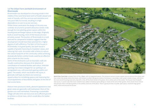
Aerial View from East: compact form of the village, with its integrated spaces. The entrance avenue crosses a green area to arrive at the school, and<br />
then enters the estate where the street, with houses on either side gives a sense of enclosure. A secondary road system creates a loop, with link to<br />
the more recent housing extension, (top left). Links off the Main Street at the green, link to other parts of the estate. The houses have footpath<br />
rear access. It can be seen that most residents have added workshop type buildings or sheds at the end of their garden. Most streets have mature<br />
tree growth which contribute greatly to the settled character of the place. There is good provision of public open space, small and large green<br />
areas, within and around the houses.<br />
<strong>Rivermeade</strong> Village Development Framework Plan iCON Architecture | Urban Design | Conservation, with Cummins and Voortman 9


