Prognosis and mitigation strategy for major landslide-prone areas Varunavat Parvat landslide in Uttarkashi
Prognosis and mitigation strategy for major landslide-prone areas A case study of Varunavat Parvat landslide in Uttarkashi township of Uttarakhand (India)
Prognosis and mitigation strategy for major landslide-prone areas A case study of Varunavat Parvat landslide in Uttarkashi township of Uttarakhand (India)

You also want an ePaper? Increase the reach of your titles
YUMPU automatically turns print PDFs into web optimized ePapers that Google loves.
Introduction<br />
Himalaya isolates the Indian subcont<strong>in</strong>ent from the rest of Asia. This highest <strong>and</strong><br />
youngest mounta<strong>in</strong> of the world was <strong>for</strong>med as a result of the com<strong>in</strong>g together <strong>and</strong><br />
eventual collision of India <strong>and</strong> ma<strong>in</strong>l<strong>and</strong> Asia. The people of Himalaya have borne the<br />
consequences of the quickened paces of the earth’s processes <strong>in</strong>clud<strong>in</strong>g the<br />
ever-threaten<strong>in</strong>g natural hazards (Valdiya, 2001). Major part of the state of<br />
Uttaranchal (now called as Uttarakh<strong>and</strong>) lies <strong>in</strong> the fragile mounta<strong>in</strong> belt of<br />
Himalaya <strong>and</strong> has experienced tectonic turmoil several times <strong>in</strong> the distant past.<br />
Dur<strong>in</strong>g the last quarter of twentieth century there has been an <strong>in</strong>crease <strong>in</strong> the frequency<br />
of natural disasters <strong>in</strong> this region. Major disasters <strong>in</strong> the last few years <strong>in</strong>clude<br />
<strong>Uttarkashi</strong> Earthquake of 1991, Chamoli Earthquake of 1999, <strong>in</strong>famous l<strong>and</strong>slides of<br />
Okhimath <strong>and</strong> Malpa <strong>in</strong> the year 1998 <strong>and</strong> cloudbursts <strong>and</strong> flash floods <strong>in</strong> Khetgaon<br />
<strong>and</strong> Budakedar area dur<strong>in</strong>g the monsoons of the year 2002. Sudden <strong>in</strong>crease <strong>in</strong><br />
anthropogenic activities like unplanned cutt<strong>in</strong>g of slope, blast<strong>in</strong>g of highly jo<strong>in</strong>ted rock<br />
mass <strong>for</strong> road construction <strong>and</strong> unplanned disposal of the slope cut debris have further<br />
added to the fragility of Himalayan mounta<strong>in</strong>s <strong>and</strong> consequently there has been an<br />
<strong>in</strong>crease <strong>in</strong> the vulnerability of this region to natural disasters (Uniyal <strong>and</strong> Prasad,<br />
2006).<br />
In the first decade of the twenty-first century no other l<strong>and</strong>slide <strong>in</strong> Himalayan region<br />
got more media attention than the l<strong>and</strong>slide events from the hill called <strong>Varunavat</strong><br />
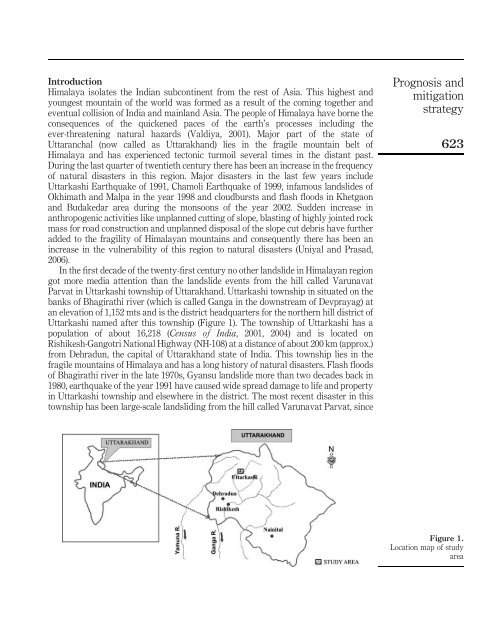
<strong>Parvat</strong> <strong>in</strong> <strong>Uttarkashi</strong> township of Uttarakh<strong>and</strong>. <strong>Uttarkashi</strong> township <strong>in</strong> situated on the<br />
banks of Bhagirathi river (which is called Ganga <strong>in</strong> the downstream of Devprayag) at<br />
an elevation of 1,152 mts <strong>and</strong> is the district headquarters <strong>for</strong> the northern hill district of<br />
<strong>Uttarkashi</strong> named after this township (Figure 1). The township of <strong>Uttarkashi</strong> has a<br />
population of about 16,218 (Census of India, 2001, 2004) <strong>and</strong> is located on<br />
Rishikesh-Gangotri National Highway (NH-108) at a distance of about 200 km (approx.)<br />
from Dehradun, the capital of Uttarakh<strong>and</strong> state of India. This township lies <strong>in</strong> the<br />
fragile mounta<strong>in</strong>s of Himalaya <strong>and</strong> has a long history of natural disasters. Flash floods<br />
of Bhagirathi river <strong>in</strong> the late 1970s, Gyansu l<strong>and</strong>slide more than two decades back <strong>in</strong><br />
1980, earthquake of the year 1991 have caused wide spread damage to life <strong>and</strong> property<br />
<strong>in</strong> <strong>Uttarkashi</strong> township <strong>and</strong> elsewhere <strong>in</strong> the district. The most recent disaster <strong>in</strong> this<br />
township has been large-scale l<strong>and</strong>slid<strong>in</strong>g from the hill called <strong>Varunavat</strong> <strong>Parvat</strong>, s<strong>in</strong>ce<br />
<strong>Prognosis</strong> <strong>and</strong><br />
<strong>mitigation</strong><br />
<strong>strategy</strong><br />
623<br />
Figure 1.<br />
Location map of study<br />
area