Prognosis and mitigation strategy for major landslide-prone areas Varunavat Parvat landslide in Uttarkashi
Prognosis and mitigation strategy for major landslide-prone areas A case study of Varunavat Parvat landslide in Uttarkashi township of Uttarakhand (India)
Prognosis and mitigation strategy for major landslide-prone areas A case study of Varunavat Parvat landslide in Uttarkashi township of Uttarakhand (India)

Create successful ePaper yourself
Turn your PDF publications into a flip-book with our unique Google optimized e-Paper software.
DPM<br />
17,5<br />
626<br />
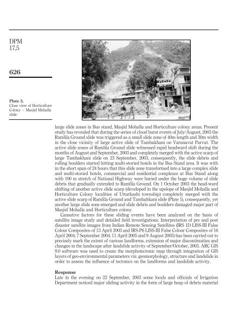
Plate 5.<br />
Close view of Horticulture<br />
Colony – Masjid Mohalla<br />
slide<br />
large slide zones <strong>in</strong> Bus st<strong>and</strong>, Masjid Mohalla <strong>and</strong> Horticulture colony <strong>areas</strong>. Present<br />
study has revealed that dur<strong>in</strong>g the series of cloud burst events of July/August, 2003 the<br />
Ramlila Ground slide was triggered as a small slide zone of 40m length <strong>and</strong> 30m width<br />
<strong>in</strong> the close vic<strong>in</strong>ity of large active slide of Tambakhani on <strong>Varunavat</strong> <strong>Parvat</strong>. The<br />
active slide zones of Ramlila Ground slide witnessed rapid headward shift dur<strong>in</strong>g the<br />
months of August <strong>and</strong> September, 2003 <strong>and</strong> completely merged with the active scarp of<br />
large Tambakhani slide on 23 September, 2003, consequently, the slide debris <strong>and</strong><br />
roll<strong>in</strong>g boulders started hitt<strong>in</strong>g multi-storied hotels <strong>in</strong> the Bus St<strong>and</strong> area. It was with<br />
<strong>in</strong> the short span of 24 hours that this slide zone trans<strong>for</strong>med <strong>in</strong>to a large complex slide<br />
<strong>and</strong> multi-storied hotels, commercial <strong>and</strong> residential complexes at Bus St<strong>and</strong> along<br />
with 100 m stretch of National Highway were buried under the huge volume of slide<br />
debris that gradually extended to Ramlila Ground. On 1 October 2003 the head-ward<br />
shift<strong>in</strong>g of another active slide scarp (developed <strong>in</strong> the upslope of Masjid Mohalla <strong>and</strong><br />
Horticulture Colony localities of <strong>Uttarkashi</strong> township) completely merged with the<br />
active slide scarp of Ramlila Ground <strong>and</strong> Tambahkani slide (Plate 1), consequently, yet<br />
another large slide zone emerged <strong>and</strong> slide debris <strong>and</strong> boulders damaged <strong>major</strong> part of<br />
Masjid Mohalla <strong>and</strong> Horticulture colony.<br />
Causative factors <strong>for</strong> these slid<strong>in</strong>g events have been analyzed on the basis of<br />
satellite image study <strong>and</strong> detailed field <strong>in</strong>vestigations. Interpretation of pre <strong>and</strong> post<br />
disaster satellite images from Indian Remote Sens<strong>in</strong>g Satellites (IRS 1D LISS-III False<br />
Colour Composites of 13 April 2003 <strong>and</strong> IRS-P6 LISS-III False Colour Composites of 16<br />
April 2004; 7 September 2004; 11 April 2005 <strong>and</strong> 9 August 2005) has been carried out to<br />
precisely mark the extent of various l<strong>and</strong><strong>for</strong>ms, extension of <strong>major</strong> discont<strong>in</strong>uities <strong>and</strong><br />
changes <strong>in</strong> the l<strong>and</strong>scape after l<strong>and</strong>slide activity of September/October, 2003. ARC GIS<br />
9.0 software was used to create the morphotectonic map through <strong>in</strong>tegration of GIS<br />
layers of geo-environmental parameters viz. geomorphology, structure <strong>and</strong> l<strong>and</strong>slide <strong>in</strong><br />
order to assess the <strong>in</strong>fluence of tectonics on the l<strong>and</strong><strong>for</strong>ms <strong>and</strong> l<strong>and</strong>slide activity.<br />
Response<br />
Late <strong>in</strong> the even<strong>in</strong>g on 23 September, 2003 some locals <strong>and</strong> officials of Irrigation<br />
Department noticed <strong>major</strong> slid<strong>in</strong>g activity <strong>in</strong> the <strong>for</strong>m of large heap of debris material