

wyndham north precinct structure plans - Growth Areas Authority
wyndham north precinct structure plans - Growth Areas Authority
wyndham north precinct structure plans - Growth Areas Authority

Create successful ePaper yourself
Turn your PDF publications into a flip-book with our unique Google optimized e-Paper software.
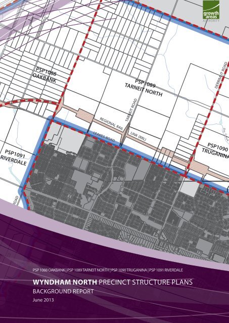
PSP1091<br />
RIVERDALE<br />
DAVIS ROAD<br />
Davis Cr eek<br />
PSP1088<br />
OAKBANK<br />
PSP1089<br />
TARNEIT NORTH<br />
REGIONAL RAIL LINK (RRL)<br />
LEAKES ROAD<br />
TARNEIT ROAD<br />
PSP 1088 OAKBANK | PSP 1089 TARNEIT NORTH | PSP 1090 TRUGANINA | PSP 1091 RIVERDALE<br />
WYNDHAM NORTH PRECINCT STRUCTURE PLANS<br />
BACKGROUND REPORT<br />
June 2013<br />
DERRIMUT ROAD<br />
Dr y Cree k<br />
PSP1090<br />
TRUGANINA
ii<br />
WYNDHAM NORTH BACKGROUND REPORT<br />
3 June 2013 1:11 PM
CONTENTS<br />
1.0 CONTEXT 2<br />
1.1 Introduction 2<br />
1.2 Metropolitan and Regional Context 2<br />
2.0 CURRENT ENVIRONMENT 7<br />
2.1 Aboriginal Cultural Heritage 7<br />
2.2 Post – Contact Cultural Heritage 7<br />
2.3 Topography and Landform 8<br />
2.4 Catchments and Drainage 8<br />
2.5 Biodiversity 9<br />
2.6 Site Contamination 9<br />
3.0 FUTURE DEVELOPMENT AND COMMUNITY 10<br />
3.1 Structure 10<br />
3.2 Town centres & employment 10<br />
3.3 Housing 11<br />
3.4 Streetscapes 12<br />
3.5 Open space 13<br />
3.6 Community Facilities, Education & Emergency Services 14<br />
3.7 Integrated Water Management 16<br />
3.8 Services 16<br />
3.9 Infra<strong>structure</strong> Funding 16<br />
TABLES<br />
WYNDHAM NORTH BACKGROUND REPORT<br />
DOCUMENT FOR PUBLIC COMMENT<br />
In June 2013 the Precinct Structure Plan (PSP) for<br />
Riverdale (PSP 1091) will be released for public comment.<br />
The PSP for Truganina (PSP 1090) is expected to be<br />
released for public comment in July 2013.<br />
The PSPs for Oakbank (PSP 1088) and Tarneit North (PSP<br />
1089) are under preparation and are expected to be<br />
released for public comment in late 2013.<br />
Table 1 Heritage Places for Retention 8<br />
Table 2 Retail Centres 10<br />
Table 3 City of Wyndham Community Infra<strong>structure</strong> Hierarchy - WSIP Framework 2040 14<br />
1
2<br />
WYNDHAM NORTH BACKGROUND REPORT<br />
1.0 CONTEXT<br />
1.1 Introduction<br />
The Wyndham North sub-corridor, located within the City of Wyndham, spans the four Precinct Structure<br />
Plan areas of Oakbank (1088), Tarneit North (1089), Truganina (1090), and Riverdale (1091). The area is<br />
situated at the edge of Melbourne’s western employment corridor, approximately 25 kilometres west of the<br />
city centre and 45 kilometres <strong>north</strong>-east of Geelong.<br />
The Wyndham North <strong>precinct</strong> consists of more than 3,000 hectares of land in the Urban <strong>Growth</strong> Zone (UGZ)<br />
within the localities of Truganina, Tarneit and Mount Cottrell.<br />
Wyndham North also forms a significant part of the Melbourne West <strong>Growth</strong> Corridor which extends across<br />
both the City of Wyndham and the City of Melton from the Princes Freeway in the south to the Melton<br />
Highway in the <strong>north</strong>.<br />
The City of Wyndham is expected to grow by a further 377,000 residents and provide an additional 164,000<br />
jobs over the next 30 years. With more than 2,500 hectares of net developable residential land and the<br />
potential to accommodate at least 110,000 people and more than 20,000 jobs, Wyndham North will<br />
account for a significant portion of the corridor’s total growth.<br />
This background report will assist in providing context and explaining the processes that informed the<br />
preparation of the four Precinct Structure Plans and their associated documents including the PSPs,<br />
Development Contributions Plan (DCP) and Native Vegetation Precinct Plans (NVPP).<br />
1.2 Metropolitan and Regional Context<br />
The City of Wyndham is located in the south-west of metropolitan Melbourne on the coast of Port Phillip<br />
Bay. It has regional links to the coastal city of Geelong, approximately 45 kilometres south-west, and is<br />
neighboured by the rapidly growing City of Melton to the <strong>north</strong>. The City of Wyndham is approximately 30<br />
kilometres west of Melbourne’s city centre, 35 kilometres south-west of Tullamarine International Airport<br />
and 37 kilometres <strong>north</strong>–east of Avalon Airport.<br />
Wyndham, along with the City of Melton, forms part of the Melbourne West <strong>Growth</strong> Corridor Plan which<br />
sets the strategic direction for future metropolitan growth and identifies areas for businesses, employment<br />
and housing, as well as setting out new transport networks, and biodiversity areas.<br />
The eastern part of the municipality is within the western employment corridor which has the largest<br />
concentration of manufacturing and logistics jobs within metropolitan Melbourne.<br />
1.2.1 Local Context<br />
The City of Wyndham is the fastest growing municipality in Victoria and one of the fastest growing regions<br />
in Australia. The Wyndham North sub-corridor is the last large tract of urban growth zoned land within the<br />
municipality and sits inside the <strong>north</strong>ern boundary with the City of Melton.<br />
The individual <strong>precinct</strong>s are generally defined as follows:<br />
• PSP 1088 – Future Outer Metropolitan Ring transport corridor to the <strong>north</strong>-east, Davis Road to the east,<br />
Regional Rail Link to the south-east, and the Werribee River to the south.<br />
• PSP1089 – Boundary Road to the <strong>north</strong>, Derrimut Road to the east, Leakes Road to the south, and Davis<br />
Road to the west.<br />
• PSP 1090 – Boundary Road to the <strong>north</strong>, generally the Regional Rail Link or future Forsyth Road extension<br />
to the east, Leakes Road to the south, and Derrimut Road to the west.<br />
• PSP 1091 – Regional Rail Link to the <strong>north</strong>, Davis Road to the east, Davis Creek to the south-east, and<br />
the Werribee River to the south and west.<br />
3 June 2013 1:11 PM
1.2.2 History<br />
WYNDHAM NORTH BACKGROUND REPORT<br />
There are three traditional owners of the land in Wyndham North including the Bunurong, Boonwurrung<br />
and Wurundjeri. The land is situated within the boundaries of the Woi wurrung language group.<br />
European settlement occurred across the Werribee plains through the 1840s and 1850s as pastoralists<br />
moved west from the city of Melbourne. The Chirnside family in particular held a large sheep run in the<br />
general Werribee area. Later by the 1940s dairy farming, market gardening, fruit growing and poultry<br />
farming had also been introduced in the area.<br />
Relics, ruins and places of cultural importance of both populations remain across the corridor. The Truganina<br />
<strong>precinct</strong> (PSP 1090) is of particular significance given the array of bluestone ruins and artefact scatters<br />
along Skeleton Creek.<br />
1.2.3 Lot Size, Ownership Pattern and Topography<br />
The Wyndham North <strong>precinct</strong> is made up of over 3,000 hectares of mixed pastoral lots and smaller semiurban<br />
subdivisions.<br />
The corridor is characterised by flat plains and scoured channels, including the Werribee River, Skeleton<br />
creek, Dry Creek and Davis Creek. The topography is flat and vegetation has largely been previously cleared<br />
for agriculture.<br />
1.2.4 Surrounding Neighbourhoods<br />
The Wyndham North <strong>precinct</strong>s are adjacent to the established suburbs of Hoppers Crossing and Tarneit. To<br />
the south-west is Wyndham Vale growth corridor which comprises eight PSPs and is expected to have an<br />
ultimate population of some 75,000 people.<br />
Boundary Road forms the boundary between Wyndham and Melton and marks the <strong>north</strong>ern edge to the<br />
<strong>precinct</strong>s, with the township of Eynesbury (Melton City) and Caroline Springs (Melton City) within close<br />
proximity.<br />
3
4<br />
WYNDHAM NORTH BACKGROUND REPORT<br />
1.2.5 Transport and Movement<br />
FREEWAY AND ARTERIAL ROAD NETWORK<br />
The corridor is well connected in all directions through the arterial road and freeway network. Major existing<br />
and planned future connections include:<br />
• Leakes Road link to the Princes Freeway with onward connections to both the Melbourne city centre<br />
and Geelong.<br />
• Boundary Road link to the Western Ring Road with onward connection to the <strong>north</strong>ern suburbs and<br />
Tullamarine International Airport.<br />
• Derrimut Road links to both Melton in the North and Werribee and the East Werribee Employment<br />
Precinct in the south.<br />
• Forsyth Road links <strong>north</strong> to Caroline Springs and south to Point Cook.<br />
Plans for the construction of the Outer Metropolitan Ring Road will further increase the corridor’s regional<br />
link. The project will provide both freight rail and freeway links from the Princes Freeway and Melbourne-<br />
Geelong railway <strong>north</strong> to Melbourne International Airport in Tullamarine and beyond.<br />
PEDESTRIAN AND CYCLE NETWORK<br />
The major waterways of Werribee River and Skeleton Creek provide shared trail connections into and<br />
through the existing urban areas.<br />
Both waterways also provide connection to the Federation Bike Trail which stretches 24 kilometres east to<br />
the Melbourne city centre.<br />
Plans for the long-term connection of the Werribee River shared trail through the grasslands to Melton have<br />
been prepared. The trail will also be extended further south to Port Phillip Bay.<br />
EXISTING RAIL SERVICES<br />
The Werribee suburban rail line, providing connection to the Melbourne city centre, runs through the<br />
southern part of the municipality, approximately 11 kilometres south of the Wyndham North <strong>precinct</strong>s.<br />
Stations are located at Werribee, Hoppers Crossing, Aircraft and Laverton with an additional station to<br />
open at Williams Landing in 2013.<br />
Regional services connecting to Geelong and Warrnambool also depart from Werribee station.<br />
EXISTING LOCAL BUS SERVICES<br />
There is no existing bus network in the Wyndham North <strong>precinct</strong>. There are established bus routes in the<br />
existing suburbs of Tarneit and Truganina which provided limited connections to Hoppers Crossing and<br />
Werribee.<br />
FUTURE SERVICES<br />
At the time of writing, construction had commenced on the Regional Rail Link, a new rail line traversing<br />
through the Wyndham North corridor that will carry regional services between Warrnambool, Geelong and<br />
Melbourne. Four stations are proposed within the corridor at Riverdale (Sayers Road), Davis Road, Tarneit,<br />
and Truganina. Tarneit station will open in 2016 with the other three to be delivered at some point in the<br />
future.<br />
In the short term services will be limited to the existing regional schedule however the line has been<br />
designed to allow for future capacity expansions, including the introduction of suburban services. Under<br />
the Melbourne West <strong>Growth</strong> Corridor Plan the Priority Public Transport Network will also be extended<br />
through the Wyndham North sub-corridor. Routes have been proposed along Forsyth, Dohertys, Derrimut,<br />
Davis, Sayers, and Armstrong Roads. The network will link the two major activity centres to the wider<br />
metropolitan area.<br />
3 June 2013 1:11 PM
1.2.6 Town Centres and Employment<br />
WERRIBEE TOWNSHIP<br />
WYNDHAM NORTH BACKGROUND REPORT<br />
Werribee Township is the historical centre of the region and still plays an important metropolitan role as an<br />
established principle town centre, offering retail and commercial services.<br />
Within the municipality, additional centres have emerged at:<br />
• Werribee Plaza, Derrimut Road, Werribee<br />
• Wyndham Village Shopping Centre, 380 Sayers Road, Tarneit<br />
Approvals are also in place for a local town centre, directly south of Truganina (PSP 1090) on the corner of<br />
Leakes and Derrimut Road within the Rose Grange estate.<br />
EAST WERRIBEE EMPLOYMENT PRECINCT<br />
Wyndham North sits on the edge of the largely logistics-based western employment corridor. This emerging<br />
area is becoming a nationally significant base for distribution centres and related services. The wider region<br />
also includes a large number of industrial and manufacturing businesses.<br />
In addition, <strong>plans</strong> for a major employment and business hub within central Werribee have been released.<br />
The East Werribee Employment Precinct is expected to eventually cater for more than 50,000 local jobs<br />
across research and development, health and learning.<br />
The new employment <strong>precinct</strong> has the potential to significantly alter the relationship between Wyndham<br />
and the metropolitan region with a higher level of local employment and a shift from predominantly eastwest<br />
travel patterns toward a greater proportion of <strong>north</strong>-south inter regional movement.<br />
1.2.7 Open Space and Natural Features<br />
Waterways form the most significant component of open space and most important natural feature within<br />
the Wyndham North sub-corridor. The Werribee River, Davis Creek, Skeleton Creek and Dry Creek create<br />
important recreation opportunities and provide extensive links into and across the local area.<br />
WATERWAYS WITHIN THE PRECINCT:<br />
• Werribee River – Forms the western edge of Riverdale (1091) and Oakbank (1088). Connects the <strong>precinct</strong><br />
with Presidents Park, the Werribee city centre, the Federation Trail and eventually Port Phillip Bay.<br />
• Davis Creek – Forms the eastern perimeter of Riverdale (1091) and joins the Werribee River at the southeastern<br />
corner. The tributaries of the creek provide further connections through Oakbank (PSP 1088).<br />
• Skeleton Creek – Skeleton Creek runs directly <strong>north</strong> to south through Truganina (PSP 1090) and links<br />
through Tarneit, Hoppers Crossing, and Point Cook.<br />
• Dry Creek – Dry Creek runs <strong>north</strong>-west to south-east through PSP 1088 and 1089 before joining Skeleton<br />
Creek in PSP 1090.<br />
EXISTING ACTIVE OPEN SPACE SURROUNDING THE WYNDHAM NORTH PRECINCT:<br />
• Wootten Road Reserve – East of PSP 1091 on Hogans Road, Tarneit. This reserve includes 2 senior ovals<br />
and 12 standard tennis courts<br />
• Presidents Park – South of PSP 1091 on Heaths Road, Wyndham Vale. This park includes softball, baseball<br />
and hockey fields, a skate park, adventure playground and walking tracks<br />
• Goddard Street Reserve – South of PSP 1089 on the corner of Penrose Promenade and Goddard Street,<br />
Tarneit. It includes three sports grounds, one of which will be a part of the future Tarneit Central School<br />
OTHER NOTABLE AREAS OF OPEN SPACE WITHIN THE WIDER AREA:<br />
• Werribee Park Mansion - South Drive, Werribee South and south of the Wyndham North <strong>precinct</strong><br />
• The Point Cook Costal Park – Point Cook Homestead Road, Point Cook and south-east of the Wyndham<br />
North <strong>precinct</strong><br />
• Werribee South coastline –Beach Road, Werribee South and south of the Wyndham North <strong>precinct</strong><br />
A 400 hectare regional park is planned along the Werribee River and will include land within southern<br />
5
6<br />
WYNDHAM NORTH BACKGROUND REPORT<br />
section of Riverdale (PSP 1091). This park, called the Werribee Township Regional Park, will be implemented<br />
over time as the surrounding land is developed.<br />
1.2.8 Community Facilities and Education<br />
The Wyndham North <strong>precinct</strong> is in close proximity to the following community facilities and schools:<br />
PRIMARY SCHOOL<br />
• St Francis of Assisi Primary School, Corner Manna Gum Drive and Fairview Parade, Tarneit<br />
• Bethany Catholic Primary School, 80 Thames Boulevard, Werribee North<br />
SECONDARY SCHOOL<br />
• Thomas Carr Secondary College, 35 Thomas Carr Drive, Tarneit<br />
• Baden Powell College 81 Baden Powell Drive, Tarneit<br />
• Good News Lutheran School, 580 Tarneit Road, Tarneit<br />
• Tarneit Senior College (years 10 – 12), 861 Leakes Road, Tarneit<br />
• Al Taqwa Islamic College (years P-12), 201 Sayers Road, Truganina<br />
KINDERGARTEN (4 YEAR OLD)<br />
• Tarneit Kindergarten, 150 Sunset Views Boulevard, Tarneit<br />
• Tarneit Central Kindergarten (opening in 2013), 21-23 Brinbrook Street, Tarneit<br />
COMMUNITY CENTRES<br />
• Tarneit Community Learning Centre, 150 Sunset Views Boulevard, Tarneit<br />
• Grange Community Centre, 260 – 280 Hogans Road, Hoppers Crossing<br />
RETIREMENT COMMUNITIES<br />
• Palm Lake Resort, 1 Andrew Road, Truganina<br />
• Rose Grange Retirement Village, Leakes Road, Tarneit<br />
• Lifestyle Seasons Retirement Village, 13 Sundial Boulevard, Tarneit<br />
• Tarneit Skies Retirement Village, 250 Thames Boulevard, Tarneit<br />
OTHER HIGH LEVEL COMMUNITY FACILITIES IN THE WIDER AREA:<br />
• Werribee Mercy Hospital, 300 Princes Highway, Werribee<br />
• Wyndham Leisure and Events Centre, 80 Derrimut Road, Hoppers Crossing<br />
• Wyndham Cultural Centre, 177 Watton St, Werribee<br />
3 June 2013 1:11 PM
2.0 CURRENT ENVIRONMENT<br />
2.1 Aboriginal Cultural Heritage<br />
WYNDHAM NORTH BACKGROUND REPORT<br />
The GAA engaged Archaeological & Heritage Management Solutions (AHMS) to undertake a standard<br />
cultural heritage assessment and complete a heritage report for the whole Wyndham North corridor.<br />
The results of the assessment identified that the highest potential for Aboriginal places exist in close<br />
proximity to the watercourses of the Werribee River, Davis Creek, Dry Creek and Skeleton Creek. The<br />
assessment revealed 51 Aboriginal places in the <strong>precinct</strong>, of which the bulk were located in close proximity<br />
to the mentioned waterways.<br />
All of the recorded places were artefact scatters, with no scar trees, burial grounds or other significant<br />
places located during the assessment. AHMS recommended that further investigations of low to very high<br />
sensitivity be undertaken to mitigate the risk of artefact discoveries impacting on construction. Development<br />
proponents will undertake further assessments as required.<br />
The report also made the recommendation that two areas within the <strong>precinct</strong> be retained as cultural<br />
heritage conservation areas. The first area was an alluvial terrace along the Werribee River corridor. Further<br />
assessment indicated that this area was likely to be the most intact portion of the river corridor within the<br />
Wyndham North <strong>precinct</strong>. The second area identified was centred on the confluence of Skeleton and Dry<br />
Creeks. Several of the identified artefact scatters were located in this area, demonstrating a strong history<br />
of indigenous occupation.<br />
The alignment of Regional Rail Link traverses both proposed conservation areas and has resulted in some<br />
amendments to the proposals put forward by AHMS. While the Werribee River terrace will be protected<br />
through the Growling Grass Frog corridor, it will be heavily modified through the construction of the rail<br />
crossing. The Skeleton Creek conservation area will be impacted to a lesser degree and through proposals<br />
put forward in the Truganina PSP (PSP 1090) will be protected (in part) as part of a larger post-contact and<br />
indigenous heritage conservation area.<br />
The AHMS heritage report has been endorsed by Aboriginal Affairs Victoria.<br />
2.2 Post – Contact Cultural Heritage<br />
The GAA commissioned post-contact heritage assessments of all four <strong>precinct</strong>s before preparing the<br />
<strong>structure</strong> <strong>plans</strong> (by Andrew Long & Associates and Context). Additional information was provided through<br />
the Wyndham North Heritage Strategy 2012 that was completed on behalf of Wyndham City.<br />
Places of significance were identified in all four <strong>precinct</strong>s (see Table 1) however the majority were in<br />
Truganina (PSP 1090). The places were largely along the banks of Skeleton Creek and around the former<br />
village of Truganina, on the corner of Woods and Dohertys Roads. The nature and spread of places in<br />
Truganina warrants the preparation of a detailed management and integration strategy.<br />
Overall, the places of significance will largely be retained as part of the open space network. Where possible<br />
the PSPs will provide guidance on their future use.<br />
In addition to the places identified, there were a number of dry stone walls in the <strong>precinct</strong> highlighted as<br />
having the potential for retention. Representatives of the GAA and Wyndham City Council assessed those<br />
walls and considered their likely potential for retention given known road widening and infra<strong>structure</strong><br />
requirements. There were several walls in Truganina and Tarneit North (PSP 1089) that were seen as being<br />
suitable for retention.<br />
7
8<br />
WYNDHAM NORTH BACKGROUND REPORT<br />
Table 1 Heritage Places for Retention<br />
NAME<br />
OAKBANK (PSP 1088)<br />
HERITAGE<br />
OVERLAY<br />
VICTORIAN<br />
HERITAGE<br />
INVENTORY<br />
Dam HO62 -<br />
TARNEIT NORTH (PSP 1089)<br />
Dohertys House HO62 -<br />
Missen House<br />
TRUGANINA (PSP 1090)<br />
Evans House (former) HO11 -<br />
Robertson Farm complex HO28 0136<br />
Leakes Wine cellars & Mullberry trees HO30 0137<br />
Early stone hut & yard HO29 0138 & 0139<br />
Itinerants’ cave - 0140<br />
Church (site) & Oak Tree HO39 -<br />
Air raid protection hall & Truganina recreation reserve HO39 -<br />
Truganina cemetery HO39 -<br />
Skeleton Creek municipal water reserve & water holes HO119 -<br />
RIVERDALE (PSP 1091)<br />
Hogan’s House HO62 -<br />
North base stone HO78 -<br />
2.3 Topography and Landform<br />
Land within the Wyndham North <strong>precinct</strong>s has largely been cleared of vegetation for agricultural purposes<br />
historically and is generally of a flat nature. Given this context the remaining vegetation is a particularly<br />
prominent feature of the landscape and mainly exists as windrows along the property boundaries or stands<br />
of trees along waterways.<br />
More generally the Wyndham North <strong>precinct</strong> is dominated by a broad volcanic plain and the Werribee River<br />
and Skeleton, Davis and Dry Creeks.<br />
2.4 Catchments and Drainage<br />
The land within the corridor generally drains south toward Port Phillip Bay through the major waterways of<br />
Werribee River and Skeleton, Davis and Dry Creeks.<br />
The incised nature of the waterways means that flooding is not a significant issue for most of the <strong>precinct</strong>.<br />
The southern portion of PSP 1091 is flatter and effected by flooding from the Werribee River.<br />
3 June 2013 1:11 PM
2.5 Biodiversity<br />
WYNDHAM NORTH BACKGROUND REPORT<br />
There are a number of flora and fauna species listed under the Commonwealth Environment Protection and<br />
Biodiversity Conservation Act 1999 that have been recorded in the study area.<br />
They are:<br />
• Golden Sun Moth<br />
• Growling Grass Frog<br />
• Striped Legless Lizard<br />
• Plains Wanderer<br />
• Spiny Rice Flower<br />
• Button Wrinklewort<br />
• Natural Temperate Grasslands<br />
Department of Sustainability and Environment (DSE) timestamp data has been used to prepare Native<br />
Vegetation Precinct Plans (NVPP) and calculate offsets. Under the Biodiversity Conservation Strategy (BCS)<br />
the areas highlighted for conservation are:<br />
• Truganina Cemetery, on Woods Road (PSP 1090).<br />
• Woods Road Golden Sun Moth Reserve, <strong>north</strong> of Leakes Road (PSP 1090).<br />
• Growling Grass Frog Reserve along the Werribee River and Davis Creek (PSP 1088 and 1091).<br />
• Spiny Rice Flower Reserve along the unmade Sewells Road reserve, south of the Regional Rail Link (PSP<br />
1091).<br />
Through the NVPP for each <strong>precinct</strong>, remnant vegetation will be retained along the existing waterways<br />
that will be kept in their natural state, particularly the Werribee River, Davis Creek (south of Sayers Road),<br />
Skeleton Creek and Dry Creek. Significant scattered indigenous trees will also be retained where possible.<br />
All other remnant vegetation has been identified as suitable for removal and offset, in line with the guidance<br />
of the NVPP for each PSP.<br />
2.6 Site Contamination<br />
Aurecon was engaged by the GAA to undertake desktop environmental, hydrological and geotechnical<br />
studies of PSPs1090 and 1091. The study indicated that both <strong>precinct</strong>s have historic and existing land uses<br />
that have the potential to cause residual contamination in soils, surface water and groundwater. Potential<br />
contaminating activities cited as concerns by the study included:<br />
• Fuel storage and fuelling operations<br />
• Heavy equipment and farm equipment storage, use and maintenance<br />
• Market gardens and glass houses where farming operations, possibly using fertilizers, pesticides and<br />
herbicides may have occurred and where faecal coliforms may be present from livestock waste<br />
• Material stockpiles consisting primarily of rock and soil<br />
• Structures where lead-based paint may have been used<br />
Overall, the potential contamination is unlikely to impact on the ability to develop the area for sensitive<br />
uses, however some remediation may be necessary.<br />
Statutory planners assessing applications for the development of sensitive uses within any of the Wyndham<br />
North PSPs should be aware of any property-specific recommendations contained within the relevant<br />
background assessment.<br />
9
10<br />
WYNDHAM NORTH BACKGROUND REPORT<br />
3.0 FUTURE DEVELOPMENT AND COMMUNITY<br />
The following chapter provides an overview of the preparation process for the four Wyndham North PSPs<br />
and how the background information has influenced the <strong>plans</strong>.<br />
A whole of corridor approach has been taken in assessing both the needs of the new community and<br />
preparing the <strong>plans</strong>. Consequently <strong>precinct</strong>s should not be looked at in isolation when considering the<br />
allocation of town centres, open space, community facilities and schools.<br />
3.1 Structure<br />
The arterial road network is generally pre-determined by the square-mile grid. Deviations from this existing<br />
<strong>structure</strong> occurs to the western end of the sub-corridor in response to the Werribee River and railway line.<br />
The connector road network has been designed to maximise connectivity to and between town centres.<br />
The alignment of connector roads has also been designed t to enable drivers, pedestrians and cyclists who<br />
use these roads to enjoy interaction with the open space network (including the numerous waterways<br />
throughout the area).<br />
As a broad principle, each square mile has a sporting reserve as a central focus with three out of every four<br />
square miles also including a town centre and primary school.<br />
3.2 Town centres & employment<br />
3.2.1 Town centre distribution<br />
<strong>Growth</strong> corridor <strong>plans</strong>: Activity centre and employment planning (2011), prepared by Essential Economics<br />
as part of the growth corridor planning process, provides an assessment of the appropriate hierarchy and<br />
scale of town centres across Melbourne’s growth areas and an overview of the population required to<br />
sustain the viability of retail provision.<br />
Table 2 Retail Centres<br />
CENTRE<br />
INDICATIVE RETAIL FLOOR<br />
SPACE (M2)<br />
INDICATIVE CATCHMENT<br />
(PEOPLE)<br />
Major town centre 50,000 55,000<br />
Local town centre 7,000 8,000 to 10,000<br />
Local convenience centre 1,500 -<br />
Volume 2 of the PSP guidelines includes the standard that 80-90 per-cent of homes should be within one<br />
kilometre of a town centre. This desire for a distributed network of town centres leads to a basic spatial<br />
pattern of three town centres for every four square miles. Responding to the standard, Essential Economics<br />
have noted “residential yields in growth areas will need to be sufficiently high to ensure that population<br />
levels in each neighbourhood unit are large enough to support a supermarket-based centre.”<br />
Waterways, conservation areas, and employment zones all impact on residential yield by reducing<br />
developable area. Further, the regional rail link represents a physical barrier that impacts neighbourhood<br />
connectivity and the ability to access local centres.<br />
The PSPs respond to the standards, assessment by Essential Economics, and local constraints by<br />
recommending higher housing densities in appropriate locations to ensure that viability of individual<br />
centres is not compromised. This approach is discussed further in section 3.3.<br />
3 June 2013 1:11 PM
3.2.2 Major Town Centres<br />
WYNDHAM NORTH BACKGROUND REPORT<br />
The Melbourne West <strong>Growth</strong> Corridor Plan set the framework for the development of major town centres<br />
across Melbourne’s growth corridors. Within Wyndham North the <strong>plans</strong> nominate major town centres<br />
adjacent to both the Tarneit and Riverdale train stations.<br />
3.2.3 Local Town Centres<br />
In addition to the two major town centres, the <strong>plans</strong> propose:<br />
• Two local town centres in Oakbank (1088)<br />
• Two local town centres in Tarneit North (1089)<br />
• Two local town centres in Truganina (1090)<br />
• Two local town centres in Riverdale (1091)<br />
Where residential catchment is distant from one of the major or local centres, allowance has been made for<br />
the development of smaller convenience centres.<br />
Where a local town centre has been placed proximate to employment areas a notional 10% increase in floor<br />
space has been allowed for to account for employment generated demand.<br />
3.2.4 Employment<br />
The Melbourne West <strong>Growth</strong> Corridor Plan note that consideration is being given to the development of an<br />
intermodal freight terminal directly <strong>north</strong> of Truganina (PSP 1090) between Boundary and Middle Roads.<br />
The nature of the facility and buffer-generating land uses that may be located <strong>north</strong> and east of the<br />
Wyndham North PSPs have resulted in the nomination of a transition belt spanning the <strong>north</strong>ern and<br />
eastern edges of the corridor.<br />
There is a desire for this area to be a mix of light industry, logistics-related services and office parks. As a<br />
result there will also be a mix of appropriate industrial and commercial zones.<br />
Consultation with industry through the planning process suggested amenity would be a key driver for<br />
higher-density employers in particular. In response the <strong>plans</strong> attempt to integrate the area with the shared<br />
trail network and create hubs of open space to create a point of focus where no other amenity exists.<br />
Complimentary facilities have also been placed proximate the corridor, including sporting reserves and<br />
schools.<br />
3.3 Housing<br />
3.3.1 Approach to housing density<br />
The scheme sets a minimum average density of 15 dwellings per hectare (in accordance with the PSP<br />
Guidelines). This density has been adopted to support the viability of service and infra<strong>structure</strong> delivery.<br />
The PSPs recommend variations to this standard in response to local context. In areas were encumbrances<br />
lead to a reduced developable area, industrial and commercial zones lead to lower housing yields, or there<br />
is justification for multiple town centres in close proximity, a higher density may be recommended to ensure<br />
that the viability of service and retail provision is not undermined.<br />
Specific sites for medium and high-density housing will not be identified in the PSPs. This approach has<br />
been adopted in response to consultation with industry and the desire to allow for greater flexibility in<br />
satisfying broader housing density goals. The overall targets remain comparable to the traditional method<br />
of identifying areas for conventional, medium-density and high-density housing.<br />
The PSPs include guidance on the appropriate delivery of increased densities.<br />
11
12<br />
WYNDHAM NORTH BACKGROUND REPORT<br />
3.3.2 Approach to achieving a greater diversity of housing<br />
Wyndham City Council have actively promoted the need for a greater diversity of housing across the<br />
growth areas. Council cites both demographic and market analysis in support of their position. The GAA<br />
has actively engaged with both Council and industry in exploring the issue of diversity with the intention of<br />
implementing guidelines that satisfy the interests of all parties.<br />
From an industry perspective there is a need to maintain the ability to respond to market trends and<br />
decrease the risk of investment in non-conventional housing product. From a Government perspective<br />
there is a need to maximise the significant public investment in the Regional Rail Link and to ensure that the<br />
housing product delivered suits the diverse needs and family <strong>structure</strong>s of the new community.<br />
Further, it is important to also note that the majority of housing built in the growth areas does not require<br />
a planning permit thus efforts aimed at increasing the diversity of housing should be focussed on the range<br />
of lot sizes being delivered within new developments.<br />
The PSPs approach the issue of housing diversity by ensuring appropriate conditions exist for the delivery<br />
of greater diversity including amenity, accessibility and employment. The documents also include revised<br />
guidelines and a housing table to assist statutory planners in understanding housing diversity and the<br />
relationship between lot size and typical housing products.<br />
3.3.3 Approach to Transit-Oriented Development<br />
The Wyndham North sub-corridor is unique among growth areas in benefitting from new rail infra<strong>structure</strong><br />
prior to commencement of development. By 2016 the Regional Rail Link will be operational with services<br />
linking Tarneit station to both Melbourne and Geelong. Over the medium and long term there is potential for<br />
three additional stations to be delivered with the land acquisition process already having been completed.<br />
The wider <strong>structure</strong> plan and individual PSPs promote the widely accepted principles of transit oriented<br />
development with the intensification of land use around Tarneit station and potential future station sites.<br />
The uncertainty of the timeframe for the realisation of the three other stations does create complexity in<br />
both planning and development adjacent land appropriately.<br />
Town centres have been identified adjacent both Tarneit station and the three other locations. The intention<br />
is that the early realisation of town centres will generate a degree of intensity prior to the opening of<br />
new stations. This approach is considered to be the most appropriate balance of ensuring development<br />
responds appropriately to the significant public investment whilst not prescribing land uses and densities<br />
that will not be viable in the short term.<br />
3.4 Streetscapes<br />
The layout of streets and landscaping within streets play a vital role in reinforcing local character. This role<br />
includes providing a connection to the existing landscape character as well as creating neighbourhoods of<br />
distinctive individual character.<br />
The PSPs will provide guidance on achieving a greater diversity of streetscapes across developments as well<br />
as highlighting feature streets that directly link important components of the urban <strong>structure</strong> or retain<br />
elements of the existing environment.<br />
Each PSP document includes variations to the standard cross sections for local access streets and connector<br />
streets. There are also individual cross sections for feature streets that have been identified in each <strong>precinct</strong><br />
that will that have a unique form and character.<br />
The PSPs will also achieve improved street tree outcomes, in terms of increased tree canopy cover. Increased<br />
tree canopy cover has multiple benefits such as improve urban amenity and landscape character, more<br />
shade and lower temperatures in summer, encouraging higher levels of walking and cycling, contribution<br />
to reducing the greenhouse effect through greater carbon uptake by vegetation etc. There will be minimum<br />
standard of street tree provision for all streets, and options for alternative treatments to arterial roads to<br />
improve tree canopy cover.<br />
New requirements for better co-ordination between underground service placement and street trees are<br />
also included within the PSPs to ensure street tree outcomes are achieved.<br />
3 June 2013 1:11 PM
3.5 Open space<br />
3.5.1 Open space provision<br />
WYNDHAM NORTH BACKGROUND REPORT<br />
Open space allocation has been undertaken in accordance with Wyndham City Council’s expressed<br />
preference for the general target of 10-per-cent of Net Developable Area (NDA) to be provided as 7% active<br />
and 3% passive.<br />
3.5.2 Active open space<br />
Active open space reserves have generally been placed at the centre of each square mile with the intended<br />
advantages of:<br />
• Providing each square mile with a central community focus<br />
• Ensuring most residents live less than 800 metres from a sporting reserve<br />
• Creating a terminus and focal point for the connector road network<br />
In determining the location and level of active open space provision across the corridor, the proximity<br />
of existing reserves to the <strong>precinct</strong> boundaries has been taken into account. This has resulted in some<br />
differences in the provision between <strong>precinct</strong>s while the corridor overall meets the agreed provision targets.<br />
3.5.3 Passive open space<br />
A key objective of the Wyndham North PSP process has been to ensure that the provision of passive open<br />
space is localised and residents do not have to cross a barrier – whether it be a railway line, arterial road or<br />
connector road – to access their neighbourhood park. Further, there is a desire to have a real diversity of<br />
open space across the corridor in terms of both scale and format.<br />
Under the <strong>plans</strong> the number and range of parks would be greatly increased with the mixture ranging from<br />
formal civic spaces of more than two hectares to small pocket parks on the banks of the waterways. Each of<br />
the town centres will have a civic space of a varied size and style as the point of focus and each residential<br />
neighbourhood will have an appropriately scaled local park.<br />
An additional benefit of this approach to passive open space provision is the increased opportunities to<br />
deliver a greater choice of housing. Amenity is a key driver of higher-density housing forms and allowing<br />
the development of smaller open spaces, particularly close to town centres, will provide additional<br />
opportunities for the development of these forms of housing.<br />
Nonetheless, it is appreciated that a balance is still required and for each of the smaller open spaces created<br />
there is an equal need to ensure that larger spaces are also provided.<br />
3.5.4 Heritage retention<br />
An extension of the integrated open space network is through the retention of heritage – both physical<br />
elements such as bluestone ruins and the wider importance of the landscape. In response to the work<br />
undertaken by AHMS, Andrew Long & Associates and Context, GAA, in consultation with Wyndham City<br />
Council, Aboriginal Affairs Victoria, and Heritage Victoria, has developed a heritage strategy that tries to<br />
balance the interests of protection and development.<br />
The default position is for heritage to be retained on public land. This is largely due to the difficulty of<br />
retaining often large elements across multiple properties and ownerships. Where an item can satisfactorily<br />
be managed in private ownership then that outcome can be considered.<br />
For the most part heritage sits within the waterway corridors, particularly along Skeleton Creek. The main<br />
intention of the strategy has been to ensure that development protects the existing landscape values along<br />
the creek and presents a sensitive interface to those areas seen as being of the greatest significance.<br />
The Truganina Heritage Network that accompanies the Truganina PSP puts in place a foundation for how<br />
developers and Council can work together to achieve a high-quality outcome that protects heritage values<br />
over the long-term.<br />
13
14<br />
WYNDHAM NORTH BACKGROUND REPORT<br />
3.6 Community Facilities, Education & Emergency Services<br />
3.6.1 Community Facilities and Government Schools<br />
The preparation of the Wyndham North PSPs has been informed by research undertaken by the GAA, ASR<br />
Research and Wyndham City (Planning for Community Infra<strong>structure</strong> in <strong>Growth</strong> <strong>Areas</strong> 2008, Wyndham<br />
Social Infra<strong>structure</strong> Plan: 2040, 2012).<br />
These documents outline the requirements for community facilities by size of population. An overview of<br />
the recommended provision rations has been included in the table below.<br />
In responding to the requirements for the new population the GAA has also been cognisant of the presence<br />
of, or need for, community facilities in adjacent neighbourhoods. This approach balances the populationbased<br />
provision ratios against sensible spatial distribution.<br />
Table 3 City of Wyndham Community Infra<strong>structure</strong> Hierarchy - WSIP Framework 2040<br />
LEVEL POPULATION FACILITIES<br />
Level 1 –<br />
Local facilities<br />
Level 2 –<br />
District Facilities<br />
Level 3 –<br />
Low Sub-Municipal<br />
Up to 10,000 people<br />
Between<br />
10 and 30,000 people<br />
Between<br />
30,000 and 60,000 people<br />
• Government Primary Schools<br />
• Level 1 Community Centres<br />
• Level 1 Active Open Space<br />
• Level 1 Passive Open Space<br />
• Long Day Child Care Centres<br />
• Social Housing<br />
• Government Secondary Colleges<br />
• Catholic Primary Schools<br />
• Level 2 Indoor Recreation Centres<br />
• Level 2 Council Community Centres/Early<br />
Years facility/Neighbourhood Houses<br />
• Low Order Tennis Facilities<br />
• Low Order Youth Facilities<br />
• Maternal & Child Health<br />
• Occasional Child Care<br />
• Residential Aged Care<br />
• Libraries<br />
• Community Arts Centres<br />
• Catholic Secondary Colleges<br />
• Higher Order Active Open Space Reserves<br />
• Indoor Recreation Centres<br />
• High Order Tennis Facilities<br />
• High Order Dedicated Youth Facilities<br />
• Level 3 Council Community Centres<br />
• Early Childhood Intervention Service<br />
• Planned Activity Group Facility<br />
• Delivered Meals Facility<br />
• Adventure Playgrounds<br />
• Other Independent Schools<br />
Different facilities have different locational requirements. Generally Level 1 community centres and<br />
government schools have been located in community hubs with active open space reserves. There is a<br />
desire to integrate middle and higher-order facilities with town centres to broaden the role of the centres<br />
from retail to the focal points of community activity.<br />
3 June 2013 1:11 PM
3.6.2 Wider Impact of Population <strong>Growth</strong> on Provision Ratios<br />
WYNDHAM NORTH BACKGROUND REPORT<br />
In addition, consideration has been given to the wider municipal impact of the additional projected<br />
population within the Wyndham North-sub-corridor on the provision of higher order community facilities.<br />
At the time of preparation, Wyndham City Council advised that some of those facilities under Council<br />
responsibility may be catered for on the Council owned property on Sayers Road (spanning the Riverdale<br />
and Oakbank <strong>precinct</strong>s). Where those facilities cannot be catered for on that property it is recommended<br />
they be located within or adjacent either of the two major town centres.<br />
3.6.3 Non-government Schools<br />
The GAA has engaged extensively with the independent schools <strong>structure</strong> in the process of preparing the<br />
Wyndham North PSPs. An effort has been made to ensure the demand for independent schools is catered<br />
for and that the schools are delivered in the most appropriate locations.<br />
The overall Wyndham North <strong>plans</strong> show indicative sites for non-government primary and secondary<br />
schools. In addition, Al-Taqwa College is an existing non-government secondary school on Derrimut Road<br />
within Truganina (PSP 1090).<br />
Where possible, there is a desire to locate non-government schools close to town centres and public<br />
transport to reflect the fact their students often are drawn from a much broader catchment.<br />
3.6.4 Emergency Services<br />
A briefing was held with representatives of Department of Justice, Department of Health, Ambulance<br />
Victoria, Victoria Police, Country Fire Association (CFA), and State Emergency Services in June of 2012.<br />
The CFA advised that two additional fire stations would be required to service the corridor. One station<br />
has been notionally placed south-west of the intersection of Leakes and Davis Roads in Riverdale (PSP<br />
1091) where the land owner has indicated a desire to create an emergency services hub. The second may<br />
potentially be located south-west of the intersection of Derrimut and Boundary Roads within Tarneit North<br />
(PSP 1089).<br />
Other agencies noted that there would be a need for additional services however they were not in a<br />
position to commit to specific numbers or locations. It is recommended that higher-order facilities such as<br />
hospitals and court houses be located within either of the two major town centres. Emergency response<br />
service locations are dictated by catchment and access requirements with the preference usually toward<br />
the intersection of two arterial roads. Nonetheless, there remains a desire to locate these facilities as close<br />
to town centres as practical.<br />
15
16<br />
WYNDHAM NORTH BACKGROUND REPORT<br />
3.7 Integrated Water Management<br />
The retardation of the 100 year flood event will be provided by a number of retarding basins located<br />
throughout the <strong>precinct</strong>. Retarding basins locations have been chosen to avoid disturbance to embankments<br />
of high quality waterways.<br />
Wetlands will be co-located with retarding basins wherever possible and will provide some of the water<br />
quality treatment required for the study area. Additional stormwater quality treatment assets will be<br />
delivered through Development Services Schemes prepared by Melbourne Water, which will provide the<br />
remaining best practice stormwater quality treatment for the study area.<br />
Treated stormwater will be used as the water supply for new Growling Grass Frog wetlands along the<br />
Werribee River and Davis Creek.<br />
Opportunities for stormwater harvesting and re-use in the area have been investigated and identified in the<br />
PSPs for further consideration by City West Water, Council and Melbourne Water.<br />
3.8 Services<br />
The relevant service authorities will advise developer proponents of requirements at the time of subdivision.<br />
The GAA has engaged the relevant authorities through the planning process and has made provision for<br />
major infra<strong>structure</strong> items where notification of the need has been provided.<br />
The power-supply authority Powercor advised a new zone substation and associated sub-transmission lines<br />
will be required to fully service the full development of the Wyndham North area. The zone substation will<br />
be located in Tarneit North (PSP 1089).<br />
The gas-supply authority SP Ausnet advised a new connection to the Brooklyn-Lara pipeline will be required<br />
before full development of the Wyndham North area is compete. It is anticipated that this infra<strong>structure</strong><br />
will be provided outside of the Wyndham North <strong>precinct</strong>s.<br />
The water-supply authority City West Water advised that new potable and recycled water storage would<br />
be required within Wyndham North. Melbourne Water has acquired land and easements near Greek Hill<br />
in Oakbank (PSP 1088), however Melbourne Water and City West Water are assessing whether this site will<br />
be used for water storage purposes.<br />
3.9 Infra<strong>structure</strong> Funding<br />
A comprehensive Development Contributions Plan has been prepared in conjunction with the Wyndham<br />
North PSPs and will provide a significant contribution towards the construction of the identified<br />
infra<strong>structure</strong> items.<br />
Other funding sources that will contribute towards funding the necessary infra<strong>structure</strong> items are<br />
developer’s works, Council rate base and various Stage Government agencies. A Precinct Infra<strong>structure</strong> Plan<br />
is contained within the PSP, which also outlines responsibility for delivery of key infra<strong>structure</strong>.<br />
3 June 2013 1:11 PM
WYNDHAM NORTH BACKGROUND REPORT<br />
17
<strong>Growth</strong> <strong>Areas</strong> <strong>Authority</strong> Level 29, 35 Collins Street MELBOURNE VIC 3000<br />
www.gaa.vic.gov.au<br />
partners in creating new communities


