

riverdale native vegetation precinct plan - Growth Areas Authority
riverdale native vegetation precinct plan - Growth Areas Authority
riverdale native vegetation precinct plan - Growth Areas Authority

Create successful ePaper yourself
Turn your PDF publications into a flip-book with our unique Google optimized e-Paper software.
ISON ROAD<br />
W e r ribe e River<br />
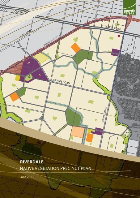
RIVERDALE<br />
Regional Rail Link<br />
SAYERS ROAD<br />
HOGANS ROAD<br />
NATIVE VEGETATION PRECINCT PLAN<br />
June 2013<br />
DAVIS ROAD<br />
LEAKES ROAD<br />
<br />
Davi s Cre ek
ii<br />
RIVERDALE NATIVE VEGETATION PRECINCT PLAN<br />
22 May 2013 6:23 PM
Contents<br />
PLANS<br />
Map 1 Area to which the NVPP applies 2<br />
Map 2 Native Vegetation to be protected and which can be removed 4<br />
TABLES<br />
RIVERDALE NATIVE VEGETATION PRECINCT PLAN<br />
1.0 INTRODUCTION 3<br />
2.0 PURPOSE 3<br />
3.0 VEGETATION PROTECTION OBJECTIVES TO BE ACHIEVED 5<br />
3.1 Requirements under Melbourne’s Strategic Assessment 5<br />
4.0 THE NATIVE VEGETATION TO BE PROTECTED 5<br />
4.1 General Requirements for Native Vegetation to be Protected 5<br />
4.2 Property Specific Requirements for Consideration of Applications to Remove<br />
Protected Native Vegetation 6<br />
4.3 Conditions for Subdivisions, Buildings and Works or Vegetation Removal within<br />
50m of Native Vegetation to be Protected as Identified in NVPP Tables 1 & 2 and<br />
shown to be Protected on NVPP Map 2 of this Native Vegetation Precinct Plan 7<br />
5.0 NATIVE VEGETATION WHICH CAN BE REMOVED, DESTROYED OR LOPPED 10<br />
5.1 Conditions For Removal of Native Vegetation 10<br />
5.2 Offset Calculations 10<br />
5.3 Procedures for the Collection of Any Payments 11<br />
6.0 REFERENCE DOCUMENT 22<br />
7.0 ACRONYMS 22<br />
NVPP Table 1 Habitat Zones to be protected 8<br />
NVPP Table 2 Scattered Tress to be protected 9<br />
NVPP Table 3 Habitat Zones which can be removed 12<br />
NVPP Table 4 Scattered Trees which can be removed, destroyed or lopped 15<br />
NVPP Table 5 Offset Requirements for Habitat Zones to be removed 16<br />
NVPP Table 6 Offset Requirements for Scattered Trees 21<br />
1
2<br />
RIVERDALE NATIVE VEGETATION PRECINCT PLAN<br />
222<br />
Native Vegetation Precinct Plan Area<br />
Property Reference Number<br />
map 1<br />
areas which the NVPP applies<br />
<strong>riverdale</strong> <strong>native</strong> <strong>vegetation</strong> <strong>precinct</strong> <strong>plan</strong><br />
N<br />
1:10,000 @ A1<br />
0 50 100<br />
350m<br />
85<br />
323<br />
227<br />
226<br />
252<br />
87<br />
SEWELLS ROAD<br />
250<br />
251<br />
223<br />
SAYERS ROAD<br />
225<br />
51<br />
249<br />
229<br />
233 232 231<br />
230<br />
228<br />
LEAKES ROAD<br />
221<br />
DAVIS ROAD<br />
222<br />
246 244 243<br />
245<br />
242<br />
257<br />
236<br />
241<br />
256<br />
235<br />
240<br />
248<br />
239<br />
238 255<br />
234<br />
247<br />
HOGANS ROAD<br />
22 May 2013 6:23 PM
1.0 INTRODUCTION<br />
This is the Riverdale Native Vegetation Precinct Plan (‘the Riverdale NVPP’) listed under the Schedule to<br />
Cluse 52.16 of the Wyndham Planning Scheme incorporated in to the Wyndham Planning Scheme pursuant<br />
to Clause 81.01.<br />
The removal, destruction or lopping of <strong>native</strong> <strong>vegetation</strong> in accordance with this Native Vegetation Precinct<br />
Plan does not require a permit provided conditions and requirements specified in this Native Vegetation<br />
Precinct Plan are met.<br />
The Riverdale Native Vegetation Precinct Plan applies to land within the NVPP area as shown on NVPP Map<br />
1, which comprises land within the Riverdale Precinct Structure Plan.<br />
The Victorian Government entered into an agreement with the Commonwealth Government, under section<br />
146 of the Environment Protection and Biodiversity Conservation Act 1999 (the EPBC Act 1999), to conduct<br />
a strategic assessment of the potential impact of ‘Delivering Melbourne’s Newest Sustainable Communities’<br />
on matters of national environmental significance (the Melbourne Strategic Assessment).<br />
For areas within Melbourne’s Strategic Assessment, the NVPP regulates the protection and offset of<br />
communities listed for protection under the EPBC Act 1999 and State <strong>native</strong> <strong>vegetation</strong>. Current EPBC<br />
approvals conducted under part 10 of the EPBC Act are based on the retention and implementation of<br />
identified offsets and compensatory habitat for communities listed under the EPBC Act in this NVPP (refer<br />
to Table 1).<br />
Within the Riverdale NVPP, the requirement for protection and offset for the Natural Temperate Grassland of<br />
the Victorian Volcanic Plain, Golden Sun Moth habitat, Growling Grass Frog habitat, Striped Legless Lizard<br />
habitat and threatened flora, including Spiny Rice Flower as outlined in the draft Biodiversity Conservation<br />
Strategy (DSE 2011) in <strong>native</strong> <strong>vegetation</strong> has been considered as part of this NVPP.<br />
2.0 PURPOSE<br />
RIVERDALE NATIVE VEGETATION PRECINCT PLAN<br />
The purpose of the Riverdale Native Vegetation Precinct Plan is to:<br />
• Apply a holistic, landscape wide approach to retention and removal of <strong>native</strong> <strong>vegetation</strong>, within the<br />
Westbrook NVPP Area as identified in NVPP Map 1.<br />
• Specify the <strong>native</strong> <strong>vegetation</strong> to be protected and the <strong>native</strong> <strong>vegetation</strong> that can be removed, destroyed<br />
or lopped.<br />
• Ensure that areas set aside to protect <strong>native</strong> <strong>vegetation</strong> are managed to conserve ecological values in<br />
accordance with the Riverdale Precinct Structure Plan.<br />
• Ensure that <strong>native</strong> <strong>vegetation</strong> specified to be protected is consistent with conserving the ecological<br />
values of these areas and is in accordance with Melbourne’s Strategic Assessment (under part 10 of the<br />
Environment Protection and Biodiversity Conservation Act 1999) and Victoria’s Vegetation Management<br />
– a Framework for Action (DSE 2002).<br />
• Set out the works of other necessary actions required to offset the removal, destruction or lopping of<br />
<strong>native</strong> <strong>vegetation</strong>.<br />
• Streamline the <strong>plan</strong>ning approvals process through a Precinct wide landscape approach to <strong>native</strong><br />
<strong>vegetation</strong> protection and management.<br />
3
222<br />
967<br />
965<br />
963<br />
970<br />
968971<br />
972<br />
961 954<br />
962<br />
Native Vegetation Precinct Plan Area<br />
Remnant patches to be retained<br />
Remnant patches to be removed<br />
Property Reference Number<br />
Scattered Trees to be retained<br />
Scattered Trees to be removed<br />
Note:<br />
Where Map 2 does not show <strong>vegetation</strong> to be retained or<br />
removed, these are areas where there is no <strong>native</strong> <strong>vegetation</strong><br />
unless an offset area has been located within this map unit.<br />
Council / DSE to advise of exact location and extent of existing<br />
<strong>native</strong> <strong>vegetation</strong> offset sites (to be shown to be retained).<br />
Scattered Trees shown to be removed are subject to futher<br />
discussion and confirmation with Council and DSE.<br />
map 2<br />
<strong>native</strong> <strong>vegetation</strong> protected & removed<br />
<strong>riverdale</strong> <strong>native</strong> <strong>vegetation</strong> <strong>precinct</strong> <strong>plan</strong><br />
N<br />
1:7,500 @ A1<br />
0 100 200<br />
700m<br />
4<br />
RIVERDALE NATIVE VEGETATION PRECINCT PLAN<br />
85<br />
323<br />
953<br />
952<br />
18<br />
226<br />
252<br />
798<br />
799<br />
800<br />
87<br />
851 849<br />
857<br />
227 858<br />
860<br />
859<br />
850<br />
868<br />
869 847<br />
993<br />
994 995<br />
989 990 991 992<br />
996<br />
997<br />
1011<br />
960<br />
957 958<br />
19 959<br />
955<br />
1013<br />
1008<br />
1010<br />
803<br />
801 804<br />
SEWELLS ROAD<br />
1015<br />
941<br />
1012<br />
1014<br />
943<br />
802<br />
988<br />
250<br />
986<br />
987<br />
1009 998<br />
SAYERS ROAD<br />
946<br />
947<br />
950<br />
834<br />
LEAKES ROAD<br />
999<br />
251<br />
223<br />
945<br />
944<br />
948<br />
949<br />
225<br />
796<br />
797<br />
794<br />
9<br />
939<br />
51<br />
807<br />
249<br />
8<br />
808<br />
233 232 231<br />
887<br />
230<br />
10<br />
1<br />
806<br />
882 884<br />
874 876<br />
888 883<br />
885 879<br />
878 872 871<br />
886<br />
875<br />
877<br />
832<br />
830<br />
828<br />
818<br />
827<br />
820<br />
836<br />
835 812<br />
819<br />
816 222<br />
831<br />
795<br />
838<br />
837<br />
823<br />
826 881<br />
880<br />
814<br />
815<br />
1000 1001 1002 1003<br />
11<br />
938 937<br />
221<br />
DAVIS ROAD<br />
228<br />
821<br />
811 813<br />
824<br />
817<br />
3<br />
810<br />
822<br />
2<br />
825<br />
229<br />
246 244 243<br />
242<br />
241<br />
240<br />
248<br />
239<br />
238<br />
889<br />
805<br />
1004 1005 1006 1007<br />
1016<br />
1017<br />
234<br />
932 931<br />
873<br />
833<br />
247<br />
245 930<br />
934<br />
HOGANS ROAD<br />
257<br />
933<br />
929<br />
928<br />
973<br />
1018<br />
926<br />
985<br />
236 984<br />
895 983<br />
896 256<br />
975 904<br />
982<br />
905 235<br />
899 906<br />
894<br />
900<br />
976 981<br />
898 974<br />
901<br />
907<br />
903<br />
917 980<br />
918 255 979<br />
910<br />
978<br />
911 919 909<br />
920<br />
924<br />
912<br />
22 May 2013 6:23 PM
3.0 VEGETATION PROTECTION OBJECTIVES TO BE ACHIEVED<br />
The objectives of this Native Vegetation Precinct Plan are:<br />
• To protect and manage <strong>native</strong> <strong>vegetation</strong> shown as ‘to be protected’ including floristic communities<br />
and species listed under the State Flora and Fauna Guarantee Act 1988 and ecological communities and<br />
species listed under the Environment Protection and Biodiversity Conservation Act 1999.<br />
• To manage the <strong>native</strong> <strong>vegetation</strong> to be protected for conservation purposes and allow for passive<br />
recreation such as walking and cycling on the edge of conservation areas, where appropriate, without<br />
damaging <strong>native</strong> <strong>vegetation</strong>.<br />
• To protect the connectivity of <strong>native</strong> <strong>vegetation</strong> within the <strong>precinct</strong> and outside the <strong>precinct</strong>.<br />
• To protect and manage the habitat zones and scattered trees identified as ‘to be protected’, as they<br />
represent the genetic lineage of site-adapted species, function to link habitat across the landscape, and<br />
provide a focus for re<strong>vegetation</strong> activities.<br />
• To maximise the ability of <strong>native</strong> <strong>vegetation</strong> to persist without human interception.<br />
• To protect and manage the long-term health and habitat value of the <strong>native</strong> <strong>vegetation</strong> specified to be<br />
protected in identified offset areas.<br />
• To provide for the protection of revegetated areas of <strong>native</strong> <strong>vegetation</strong> on offset sites as required by the<br />
responsible authority.<br />
3.1 Requirements under Melbourne’s Strategic Assessment<br />
The Victorian Government entered into an agreement with the Commonwealth Government, under<br />
section 146 of the EPBC Act, to conduct a strategic assessment of the potential impact of the ‘Delivering<br />
Melbourne’s newest sustainable communities’ on matters of national environmental significance (the<br />
Melbourne’s Strategic Assessment).<br />
This NVPP includes Federally listed <strong>native</strong> <strong>vegetation</strong> communities and species habitat that has been<br />
protected under this agreement as indicated by the column ‘EPBC Act listed ecological community’ in<br />
Tables 1 and 3 and by the column ‘Like for Like Requirements (EVC or threatened species) in Table 5. Further<br />
removal of these Federally listed <strong>native</strong> <strong>vegetation</strong> communities and species habitats (that are shown to be<br />
protected in this NVPP) is in breach of approval issued under the Melbourne’s Strategic Assessment and will<br />
require further consideration under the EPBC Act.<br />
4.0 THE NATIVE VEGETATION TO BE PROTECTED<br />
4.1 General Requirements for Native Vegetation to be Protected<br />
RIVERDALE NATIVE VEGETATION PRECINCT PLAN<br />
The <strong>native</strong> <strong>vegetation</strong> to be protected is described in NVPP Tables 1 and 2 and shown on NVPP Map 2 and<br />
should not be removed.<br />
The <strong>native</strong> <strong>vegetation</strong> shown as ‘to be protected’ is based on a landscape wide approach to retention and<br />
removal of <strong>native</strong> <strong>vegetation</strong> rather than a site by site approach.<br />
Decisions relating to the removal of areas of individual trees and / or areas of <strong>native</strong> <strong>vegetation</strong> have been<br />
made in a holistic manner taking into account habitat zones and scattered trees which are proposed to be<br />
protected. The ad hoc removal of <strong>native</strong> <strong>vegetation</strong> which is identified as ‘to be protected’ may undermine<br />
the holistic and landscape wide approach of the NVPP.<br />
In this NVPP, the protection area of a tree (including a tree in a habitat zone or a scattered tree) refers to an<br />
area of twice the canopy diameter of the tree(s) at its widest point.<br />
Protection of a scattered tree means that the protection area must be:<br />
• Protected from adverse impacts, grazing, burning and soil disturbance.<br />
• Managed to retain fallen timber, control weeds and provide intervention and or management if<br />
necessary to ensure adequate natural regeneration or <strong>plan</strong>ting can occur.<br />
• Protected from earthworks, compaction during construction and adverse modification of existing<br />
drainage patterns.<br />
5
6<br />
RIVERDALE NATIVE VEGETATION PRECINCT PLAN<br />
These protection measures may be varied if adequate justification is provided and agreed to in writing by<br />
the Department of Sustainability and Environment.<br />
The following Habitat Zones in are identified to be protected in this NVPP:<br />
• Property 234 - Habitat Zones 889, 890<br />
• Property 243 - Habitat Zones 927, 928, 929<br />
• Property 247 - Habitat Zones 933, 934, 935, 936<br />
• Property 249 - Habitat Zones 937, 938, 939, 940<br />
• Property 250 - Habitat Zones 941, 942<br />
• Property 252 - Habitat Zones 951, 952, 953, 954, 961, 962<br />
• Property 255 - Habitat Zones 974, 975, 976, 977, 978, 979, 980, 981<br />
• Property 256 - Habitat Zones 982, 983, 984, 985<br />
• Property 323 - Habitat Zones 963, 965, 966, 967, 968, 969, 970, 971, 972<br />
• Road Reserve – Habitat Zone 987<br />
They are to be protected within the Growling Grass Frog corridor along the Werribee River, Davis Creek and<br />
the Sewells Road Reserve.<br />
Trails to be provided through and alongside the Growling Grass Frog Corridor or the Sewells Road Reserve<br />
are to be designed to minimise impacts to <strong>vegetation</strong> to the satisfaction of the Department of Sustainability<br />
and Environment.<br />
To minimise the risk to trees identified as ‘scattered trees to be protected’, having to be removed at a later<br />
time, public sue areas including playgrounds, barbeques etc should be located at a minimum distance of 15<br />
metres away from identified scattered trees so as not to pose a risk to personal safety or property<br />
4.2 Property Specific Requirements for Consideration of Applications to Remove<br />
Protected Native Vegetation<br />
Clause 52.16-3 allows and application to be made for the removal of protected <strong>native</strong> <strong>vegetation</strong>. This<br />
NVPP recognises that permits for further <strong>native</strong> <strong>vegetation</strong> removal may be reasonably sought for the land<br />
listed below:<br />
• Native <strong>vegetation</strong> shown on NVPP Map 2 to be protected will require a <strong>plan</strong>ning permit for removal.<br />
The <strong>vegetation</strong> concentrated along the Werribee River or in close proximity to it may be removed in<br />
relation to the construction of the bridge crossings shown on Plan 5 in the Riverdale Precinct Structure<br />
Plan; however removal must be kept to the minimum required for the project. Any removal must be to<br />
the satisfaction of the Department of Sustainability and Environment.<br />
• Offsets and compensatory habitat fees for the <strong>native</strong> <strong>vegetation</strong> removal will be in accordance with this<br />
NVPP and DSE’s Native Vegetation Time Stamping Data.<br />
22 May 2013 6:23 PM
RIVERDALE NATIVE VEGETATION PRECINCT PLAN<br />
4.3 Conditions for Subdivisions, Buildings and Works or Vegetation Removal within 50m<br />
of Native Vegetation to be Protected as Identified in NVPP Tables 1 & 2 and shown to<br />
be Protected on NVPP Map 2 of this Native Vegetation Precinct Plan<br />
The following conditions must be included on all <strong>plan</strong>ning permits for subdivision, buildings and works or<br />
<strong>vegetation</strong> removal within 50 metres of <strong>native</strong> <strong>vegetation</strong> identified ‘to be protected’ in NVPP Tables 1 and<br />
2 and on NVPP Map 2 of this NVPP unless otherwise agreed in writing by the Department of Sustainability<br />
and Environment:<br />
• Only the <strong>native</strong> <strong>vegetation</strong> which is identified for removal in the incorporated NVPP applying to the land<br />
may be removed, destroyed or lopped.<br />
• Prior to commencement of works within 15 metres of <strong>native</strong> <strong>vegetation</strong> identified as ‘<strong>native</strong> <strong>vegetation</strong><br />
to be protected’ on NVPP Map 2 in this NVPP applying to the land, a highly visible <strong>vegetation</strong> protection<br />
fence must be erected around twice the canopy distance of each scattered tree and more than 2 metres<br />
from areas of all other <strong>native</strong> <strong>vegetation</strong> which have been identified as to be protected in the NVPP<br />
referred to in the Schedule to Clause 52.16 unless otherwise agreed to in writing by the Department of<br />
Sustainability and Environment.<br />
• Any:<br />
• Works carried out in respect of any subdivision;<br />
• Construction of buildings and associated works; and<br />
• Removal, lopping or destruction of <strong>native</strong> <strong>vegetation</strong> on the land as authorised by the NVPP;<br />
must be carried out in accordance with all of the requirements set out in the incorporated NVPP applying<br />
to the land to the satisfaction of the Responsible <strong>Authority</strong>.<br />
• Any construction stockpiles, fill and machinery must be placed away from areas supporting <strong>native</strong><br />
<strong>vegetation</strong> and drainage lines to the satisfaction of the Responsible <strong>Authority</strong>.<br />
• All earthworks must be undertaken in a manner that will minimise soil erosion and adhere to Construction<br />
Techniques for Sediment Pollution Control (EPA 1991) or updated version.<br />
• Any public open space infrastructure or trails are to be located outside a protection area of a scattered<br />
tree or Habitat Zone at an appropriate buffer distance. Public open space infrastructure provided within<br />
15 metres of <strong>native</strong> <strong>vegetation</strong> (including scattered trees and habitat zones) shown as to be protected<br />
must be constructed and designed to ensure that the <strong>native</strong> <strong>vegetation</strong> is protected from adverse<br />
impacts during construction unless otherwise agreed to in writing by the Department of Sustainability<br />
and Environment.<br />
• To minimise the risk to trees identified as ‘scattered trees to be protected’, having to be removed at<br />
a later time, public use areas including playgrounds, barbeques etc are to be located so that they are<br />
not within the protection area of the scattered trees and therefore likely to present a structural failure<br />
hazard or pose a risk to personal safety or property.<br />
• No earthworks, compaction or modification of existing drainage patterns may be undertaken which<br />
present a risk to any remnant trees, understorey or re<strong>vegetation</strong> areas.<br />
7
8<br />
RIVERDALE NATIVE VEGETATION PRECINCT PLAN<br />
NVPP Table 1: Habitat Zones to be protected<br />
PSP<br />
PROPERTY<br />
ID<br />
PROPERTY DETAILS<br />
HABITAT<br />
ZONE<br />
ECOLOGICAL VEGETATION CLASS<br />
(EVC) DESCRIPTION<br />
EVC No. and Name<br />
SIZE<br />
Hectares<br />
(Ha)<br />
EPBC LISTED<br />
VEGETATION<br />
COMMUNITY<br />
HABITAT<br />
HECTARES<br />
CONSERVATION<br />
STATUS<br />
least concern,<br />
endangered etc<br />
CONSERVATION<br />
SIGNIFICANCE<br />
low, high etc<br />
234 2 Davis Road Tarneit 3029 (2\LP84778) HZ 889 Floodplain Riparian Woodland (EVC 56) 0.75 - 0.37 Endangered Very High 13<br />
234 2 Davis Road Tarneit 3029 (2\LP84778) HZ 890 Floodplain Riparian Woodland (EVC 56) 0.30 - 0.13 Endangered Very High 3<br />
243 Hogans Road Tarneit 3029 (3\LP136754) HZ 927 Plains Grassy Wetland (EVC 125) 0.46 - 0.17 Endangered Very High<br />
243 Hogans Road Tarneit 3029 (3\LP136754) HZ 928 Plains Grassy Wetland (EVC 125) 0.57 - 0.18 Endangered Very High<br />
243 Hogans Road Tarneit 3029 (3\LP136754) HZ 929 Plains Grassland (EVC 132) 0.33 NTGVP 0.10 Endangered Very High<br />
247 180 Davis Road Tarneit 3029 (1\TP703106) HZ 933 Plains Grassland (EVC 132) 0.15 NTGVP 0.06 Endangered Very High<br />
247 180 Davis Road Tarneit 3029 (1\TP703106) HZ 934 Plains Grassland (EVC 132) 0.22 NTGVP 0.10 Endangered Very High<br />
247 180 Davis Road Tarneit 3029 (1\TP703106) HZ 935 Plains Grassy Wetland (EVC 125) 0.61 - 0.15 Endangered Very High<br />
247 180 Davis Road Tarneit 3029 (1\TP703106) HZ 936 Plains Grassy Wetland (EVC 125) 0.89 - 0.31 Endangered Very High<br />
249 23 Davis Road Tarneit 3029 (2\LP144521) HZ 937 Floodplain Riparian Woodland (EVC 56) 0.06 - 0.01 Endangered Very High<br />
249 23 Davis Road Tarneit 3029 (2\LP144521) HZ 938 Floodplain Riparian Woodland (EVC 56) 0.05 - 0.01 Endangered Very High<br />
249 23 Davis Road Tarneit 3029 (2\LP144521) HZ 939 Floodplain Riparian Woodland (EVC 56) 0.30 - 0.10 Endangered Very High 8<br />
249 23 Davis Road Tarneit 3029 (2\LP144521) HZ 940 Floodplain Riparian Woodland (EVC 56) 0.36 - 0.12 Endangered Very High 4<br />
250 Sayers Road Tarneit 3029 (1\TP138990) HZ 941 Floodplain Riparian Woodland (EVC 56) 0.04 - 0.01 Endangered Very High<br />
250 Sayers Road Tarneit 3029 (1\TP138990) HZ 942 Floodplain Riparian Woodland (EVC 56) 1.91 - 0.78 Endangered Very High 24<br />
252 85-87 Sewells Road Tarneit 3029 (4A\LP5408) HZ 951 Floodplain Riparian Woodland (EVC 56) 8.35 - 3.42 Endangered Very High 74<br />
252 85-87 Sewells Road Tarneit 3029 (4A\LP5408) HZ 952 Plains Grassland (EVC 132) 0.40 NTGVP 0.16 Endangered Very High<br />
252 85-87 Sewells Road Tarneit 3029 (4A\LP5408) HZ 953 Plains Grassland (EVC 132) 0.23 NTGVP 0.09 Endangered Very High<br />
252 85-87 Sewells Road Tarneit 3029 (4A\LP5408) HZ 954 Plains Grassland (EVC 132) 0.58 NTGVP 0.21 Endangered Very High<br />
252 85-87 Sewells Road Tarneit 3029 (4A\LP5408) HZ 961 Riparian Woodland (EVC 641) 0.07 - 0.03 Endangered Very High 2<br />
252 85-87 Sewells Road Tarneit 3029 (4A\LP5408) HZ 962 Riparian Woodland (EVC 641) 0.15 - 0.06 Endangered Very High 1<br />
323 Sayers Road Tarneit (C1~16\PP3552) formerly 1245 Sayers Road Tarneit 3029 (CP103226) HZ 963 Riparian Woodland (EVC 641) 0.08 - 0.04 Endangered Very High 1<br />
323 Sayers Road Tarneit (C1~16\PP3552) formerly 1245 Sayers Road Tarneit 3029 (CP103226) HZ 965 Riparian Woodland (EVC 641) 0.15 - 0.03 Endangered Very High 4<br />
323 Sayers Road Tarneit (C1~16\PP3552) formerly 1245 Sayers Road Tarneit 3029 (CP103226) HZ 966 Riparian Woodland (EVC 641) 0.38 - 0.11 Endangered Very High 1<br />
323 Sayers Road Tarneit (C1~16\PP3552) formerly 1245 Sayers Road Tarneit 3029 (CP103226) HZ 967 Riparian Woodland (EVC 641) 0.26 - 0.07 Endangered Very High 9<br />
323 Sayers Road Tarneit (C1~16\PP3552) formerly 1245 Sayers Road Tarneit 3029 (CP103226) HZ 968 Riparian Woodland (EVC 641) 0.06 - 0.01 Endangered Very High 1<br />
323 Sayers Road Tarneit (C1~16\PP3552) formerly 1245 Sayers Road Tarneit 3029 (CP103226) HZ 969 Riparian Woodland (EVC 641) 0.08 - 0.03 Endangered Very High 1<br />
323 Sayers Road Tarneit (C1~16\PP3552) formerly 1245 Sayers Road Tarneit 3029 (CP103226) HZ 970 Riparian Woodland (EVC 641) 0.12 - 0.02 Endangered Very High 1<br />
323 Sayers Road Tarneit (C1~16\PP3552) formerly 1245 Sayers Road Tarneit 3029 (CP103226) HZ 971 Riparian Woodland (EVC 641) 0.10 - 0.02 Endangered Very High 1<br />
323 Sayers Road Tarneit (C1~16\PP3552) formerly 1245 Sayers Road Tarneit 3029 (CP103226) HZ 972 Riparian Woodland (EVC 641) 0.17 - 0.03 Endangered Very High 3<br />
255 Riversdale Drive Tarneit 3029 (RES1\PS602466) HZ 974 Creekline Grassy Woodland (EVC 68) 0.16 - 0.05 Endangered Very High 4<br />
255 Riversdale Drive Tarneit 3029 (RES1\PS602466) HZ 975 Creekline Grassy Woodland (EVC 68) 0.03 - 0.01 Endangered Very High<br />
255 Riversdale Drive Tarneit 3029 (RES1\PS602466) HZ 976 Tall Marsh (EVC 821) 0.04 - 0.02 Vulnerable Very High<br />
255 Riversdale Drive Tarneit 3029 (RES1\PS602466) HZ 977 Creekline Grassy Woodland (EVC 68) 0.28 - 0.08 Endangered Very High 6<br />
255 Riversdale Drive Tarneit 3029 (RES1\PS602466) HZ 978 Creekline Grassy Woodland (EVC 68) 0.06 - 0.02 Endangered Very High 1<br />
255 Riversdale Drive Tarneit 3029 (RES1\PS602466) HZ 979 Tall Marsh (EVC 821) 0.03 - 0.01 Vulnerable Very High<br />
255 Riversdale Drive Tarneit 3029 (RES1\PS602466) HZ 980 Tall Marsh (EVC 821) 0.04 - 0.01 Vulnerable Very High<br />
255 Riversdale Drive Tarneit 3029 (RES1\PS602466) HZ 981 Tall Marsh (EVC 821) 0.06 - 0.01 Vulnerable Very High<br />
256 429 Hogans Road Tarneit 3029 (F\PS602466) HZ 982 Tall Marsh (EVC 821) 0.08 - 0.03 Vulnerable Very High<br />
256 429 Hogans Road Tarneit 3029 (F\PS602466) HZ 983 Tall Marsh (EVC 821) 0.19 - 0.06 Vulnerable Very High<br />
256 429 Hogans Road Tarneit 3029 (F\PS602466) HZ 984 Aquatic Herbland (EVC 653) 0.07 - 0.03 Endangered Very High<br />
256 429 Hogans Road Tarneit 3029 (F\PS602466) HZ 985 Tall Marsh (EVC 821) 0.08 - 0.03 Vulnerable Very High<br />
Road Reserve Sewells Road Tarneit HZ 987 Plains Grassland (EVC 132) 0.40 NTGVP 0.19 Endangered Very High<br />
NUMBER OF<br />
VLOTS AND<br />
LOTS IN HZ<br />
20 May 2013 2:45 PM
NVPP Table 2: Scattered Trees to be protected<br />
PSP<br />
PROPERTY<br />
ID<br />
PROPERTY DETAILS<br />
TREE ID<br />
NO.<br />
SPECIES<br />
SIZE OF<br />
TREE<br />
(VLOT, LOT,<br />
MOT)<br />
EVC NAME &<br />
NO.<br />
CONSERVATION<br />
STATUS<br />
least concern,<br />
endangered etc<br />
RIVERDALE NATIVE VEGETATION PRECINCT PLAN<br />
CONSERVATION<br />
SIGNIFICANCE<br />
low, high etc<br />
GPS<br />
COORDINATES<br />
X-LATITUDE<br />
GPS<br />
COORDINATES<br />
Y-LONGITUDE<br />
222<br />
Leakes Road Tarneit (1\PS701129) formerly Leakes Road Tarneit<br />
3029 (B~15\PP3552)<br />
1 Allocasuarina luehmannii (Buloke ) LOT Plains Woodland (EVC 803) Endangered High 2468870.499 2407127.391<br />
222<br />
Leakes Road Tarneit (1\PS701129) formerly Leakes Road Tarneit<br />
3029 (B~15\PP3552)<br />
2 Allocasuarina luehmannii (Buloke ) LOT Plains Woodland (EVC 803) Endangered High 2468921.029 2407215.221<br />
234 2 Davis Road Tarneit 3029 (2\LP84778) 4 Euacalyptus camaldulensis (River Red-gum) MOT<br />
Floodplain Riparian Woodland (EVC<br />
56)<br />
Endangered High 2468923.366 2403399.354<br />
249 23 Davis Road Tarneit 3029 (2\LP144521) 5 Euacalyptus camaldulensis (River Red-gum) MOT<br />
Floodplain Riparian Woodland (EVC<br />
56)<br />
Endangered High 2468437.678 2403830.351<br />
249 23 Davis Road Tarneit 3029 (2\LP144521) 6 Euacalyptus camaldulensis (River Red-gum) MOT<br />
Floodplain Riparian Woodland (EVC<br />
56)<br />
Endangered High 2468425.777 2403836.869<br />
249 23 Davis Road Tarneit 3029 (2\LP144521) 7 Euacalyptus camaldulensis (River Red-gum) ST<br />
Floodplain Riparian Woodland (EVC<br />
56)<br />
Endangered Low 2468413.724 2403845.744<br />
249 23 Davis Road Tarneit 3029 (2\LP144521) 8 Euacalyptus camaldulensis (River Red-gum) LOT Plains Grassy Woodland (EVC 55) Endangered High 2468616.431 2404010.568<br />
249 23 Davis Road Tarneit 3029 (2\LP144521) 9 Euacalyptus camaldulensis (River Red-gum) LOT Plains Grassy Woodland (EVC 55) Endangered High 2468564.812 2404054.178<br />
249 23 Davis Road Tarneit 3029 (2\LP144521) 10 Euacalyptus camaldulensis (River Red-gum) LOT Plains Grassy Woodland (EVC 55) Endangered High 2468694.527 2404036.6<br />
252 85-87 Sewells Road Tarneit 3029 (4A\LP5408) 12<br />
Eucalyptus baueriana subsp. Thalassina<br />
(Werribee Bluebox)<br />
LOT<br />
Floodplain Riparian Woodland (EVC<br />
56)<br />
Endangered High 2467175.77 2404428.23<br />
252 85-87 Sewells Road Tarneit 3029 (4A\LP5408) 13 Euacalyptus camaldulensis (River Red-gum) LOT<br />
Floodplain Riparian Woodland (EVC<br />
56)<br />
Endangered High 2466817.729 2404649.984<br />
252 85-87 Sewells Road Tarneit 3029 (4A\LP5408) 14 Euacalyptus camaldulensis (River Red-gum) ST<br />
Floodplain Riparian Woodland (EVC<br />
56)<br />
Endangered Low 2466943.812 2405157.263<br />
252 85-87 Sewells Road Tarneit 3029 (4A\LP5408) 15 Dead LOT<br />
Floodplain Riparian Woodland (EVC<br />
56)<br />
Endangered High 2466996.944 2405036.123<br />
252 85-87 Sewells Road Tarneit 3029 (4A\LP5408) 16 Dead MOT<br />
Floodplain Riparian Woodland (EVC<br />
56)<br />
Endangered High 2467032.045 2404837.959<br />
252 85-87 Sewells Road Tarneit 3029 (4A\LP5408) 17<br />
Eucalyptus baueriana subsp. Thalassina<br />
(Werribee Bluebox)<br />
LOT<br />
Floodplain Riparian Woodland (EVC<br />
56)<br />
Endangered High 2466475.433 2405773.701<br />
252 85-87 Sewells Road Tarneit 3029 (4A\LP5408) 18 Allocasuarina leuhmanii (Buloke ) LOT Plains Woodland (EVC 803) Endangered High 2467029.26 2405707.549<br />
252 85-87 Sewells Road Tarneit 3029 (4A\LP5408) 19 Euacalyptus camaldulensis (River Red-gum) LOT Plains Grassy Woodland (EVC 55) Endangered High 2467223.76 2405186.818<br />
255 Riversdale Drive Tarneit 3029 (RES1\PS602466) 20 Euacalyptus camaldulensis (River Red-gum) MOT Creekline Grassy Woodland (EVC 68) Endangered High 2469513.367 2404059.253<br />
255 Riversdale Drive Tarneit 3029 (RES1\PS602466) 21 Euacalyptus camaldulensis (River Red-gum) LOT Creekline Grassy Woodland (EVC 68) Endangered High 2469477.306 2403695.764<br />
255 Riversdale Drive Tarneit 3029 (RES1\PS602466) 22 Euacalyptus camaldulensis (River Red-gum) ST Creekline Grassy Woodland (EVC 68) Endangered Low 2469496.058 2403694.321<br />
255 Riversdale Drive Tarneit 3029 (RES1\PS602466) 23 Euacalyptus camaldulensis (River Red-gum) ST Creekline Grassy Woodland (EVC 68) Endangered Low 2469454.077 2403758.114<br />
255 Riversdale Drive Tarneit 3029 (RES1\PS602466) 24 Euacalyptus camaldulensis (River Red-gum) MOT Creekline Grassy Woodland (EVC 68) Endangered High 2469445.765 2403762.665<br />
255 Riversdale Drive Tarneit 3029 (RES1\PS602466) 25 Euacalyptus camaldulensis (River Red-gum) LOT Creekline Grassy Woodland (EVC 68) Endangered High 2469495.908 2403707.891<br />
255 Riversdale Drive Tarneit 3029 (RES1\PS602466) 26 Dead LOT Creekline Grassy Woodland (EVC 68) Endangered High 2469488.769 2403738.225<br />
255 Riversdale Drive Tarneit 3029 (RES1\PS602466) 27 Dead MOT Creekline Grassy Woodland (EVC 68) Endangered High 2469486.328 2403726.947<br />
255 Riversdale Drive Tarneit 3029 (RES1\PS602466) 28 Dead LOT Creekline Grassy Woodland (EVC 68) Endangered High 2469484.143 2403712.523<br />
255 Riversdale Drive Tarneit 3029 (RES1\PS602466) 29 Dead LOT Creekline Grassy Woodland (EVC 68) Endangered High 2469417.81 2403830.796<br />
255 Riversdale Drive Tarneit 3029 (RES1\PS602466) 30 Dead MOT Creekline Grassy Woodland (EVC 68) Endangered High 2469413.259 2403852.912<br />
255 Riversdale Drive Tarneit 3029 (RES1\PS602466) 31 Dead LOT Creekline Grassy Woodland (EVC 68) Endangered High 2469451.929 2403879.707<br />
255 Riversdale Drive Tarneit 3029 (RES1\PS602466) 32 Dead LOT Creekline Grassy Woodland (EVC 68) Endangered High 2469445.743 2403876.337<br />
255 Riversdale Drive Tarneit 3029 (RES1\PS602466) 33 Dead LOT Creekline Grassy Woodland (EVC 68) Endangered High 2469433.777 2403868.109<br />
255 Riversdale Drive Tarneit 3029 (RES1\PS602466) 34 Euacalyptus camaldulensis (River Red-gum) ST Creekline Grassy Woodland (EVC 68) Endangered Low 2469477.889 2403913.535<br />
255 Riversdale Drive Tarneit 3029 (RES1\PS602466) 35 Euacalyptus camaldulensis (River Red-gum) ST Creekline Grassy Woodland (EVC 68) Endangered Low 2469473.425 2403919.461<br />
255 Riversdale Drive Tarneit 3029 (RES1\PS602466) 36 Euacalyptus camaldulensis (River Red-gum) MOT Creekline Grassy Woodland (EVC 68) Endangered High 2469488.145 2403972.763<br />
255 Riversdale Drive Tarneit 3029 (RES1\PS602466) 37 Euacalyptus camaldulensis (River Red-gum) MOT Creekline Grassy Woodland (EVC 68) Endangered High 2469492.827 2403990.871<br />
255 Riversdale Drive Tarneit 3029 (RES1\PS602466) 38 Euacalyptus camaldulensis (River Red-gum) ST Creekline Grassy Woodland (EVC 68) Endangered Low 2469477.013 2403955.934<br />
255 Riversdale Drive Tarneit 3029 (RES1\PS602466) 39 Euacalyptus camaldulensis (River Red-gum) ST Creekline Grassy Woodland (EVC 68) Endangered Low 2469475.125 2403966.238<br />
255 Riversdale Drive Tarneit 3029 (RES1\PS602466) 40 Euacalyptus camaldulensis (River Red-gum) ST Creekline Grassy Woodland (EVC 68) Endangered Low 2469472.845 2403974.702<br />
255 Riversdale Drive Tarneit 3029 (RES1\PS602466) 41 Dead LOT Creekline Grassy Woodland (EVC 68) Endangered High 2469465.471 2403928.52<br />
255 Riversdale Drive Tarneit 3029 (RES1\PS602466) 42 Dead MOT Creekline Grassy Woodland (EVC 68) Endangered High 2469457.383 2403924.467<br />
9
10<br />
RIVERDALE NATIVE VEGETATION PRECINCT PLAN<br />
5.0 NATIVE VEGETATION WHICH CAN BE REMOVED, DESTROYED OR<br />
LOPPED<br />
5.1 Conditions For Removal of Native Vegetation<br />
The <strong>native</strong> <strong>vegetation</strong> described in Table 3 and shown on Map 2 as <strong>native</strong> <strong>vegetation</strong> that ‘can be removed’,<br />
can be removed, destroyed or lopped under Clause 52.16-3 of the Wyndham Planning Scheme subject to<br />
the following conditions:<br />
1. Only the <strong>native</strong> <strong>vegetation</strong> which is identified for removal in the incorporated NVPP applying to the land<br />
may be removed, lopped or destroyed without a <strong>plan</strong>ning permit.<br />
2. Before removal, destruction or lopping of any <strong>native</strong> <strong>vegetation</strong> (identified by the Property Number in<br />
Map 2 of the Riverdale NVPP) the owner of the land from which the <strong>native</strong> <strong>vegetation</strong> is being removed<br />
must provide offsets for all <strong>native</strong> <strong>vegetation</strong> within that property in accordance with Table 3 and<br />
Table 5 unless otherwise agreed to in writing by the Department of Sustainability and Environment.<br />
Removal of <strong>native</strong> <strong>vegetation</strong> must be offset to the satisfaction of the Department of Sustainability and<br />
Environment as follows:<br />
a. EVC Plains Grassland – by providing an allocated credit extract for credits from the Western<br />
Grasslands Reserve issued by the Department of Sustainability and Environment.<br />
b. For all other <strong>native</strong> <strong>vegetation</strong> by either:<br />
i. Providing an allocated credit extract issued by the Department of Sustainability and Environment<br />
for the extent of <strong>native</strong> <strong>vegetation</strong> removed; or<br />
ii. Preparing and submitting an Offset Plan to the satisfaction of the Department of Sustainability<br />
and Environment and have the Offset Plan approved by the Responsible <strong>Authority</strong> in accordance<br />
with Victoria’s Native Vegetation Management: A Framework for Action.<br />
3. Where an Offset Plan is approved:<br />
a. Before the removal, destruction or lopping of any <strong>native</strong> <strong>vegetation</strong>, the owner of the land from<br />
which the <strong>vegetation</strong> is being removed must arrange for the owner of the approved offset site to<br />
register and agreement on the land title securing the offset site in perpetuity. The owner of the<br />
land from which the <strong>vegetation</strong> is being removed must pay the reasonable costs of the preparation,<br />
execution and registration of the on-title agreement. The on-title security must provide for the<br />
implementation of the Offset Plan and be to the satisfaction of the Department of Sustainability and<br />
Environment.<br />
b. Offsets must be implemented according to the schedule of works in the Offset Plan to the satisfaction<br />
of the Department of Sustainability and Environment.<br />
4. Before the removal, destruction or lopping of <strong>native</strong> <strong>vegetation</strong>, any <strong>native</strong> <strong>vegetation</strong> to be removed<br />
must clearly be marked on site to the satisfaction of the Responsible <strong>Authority</strong> whilst works are being<br />
undertaken within the vicinity.<br />
5. Before the felling of any trees with nest or hollows the tree must be examined for fauna by a suitably<br />
qualified zoologist. If <strong>native</strong> fauna species are found, they must be salvaged and relocated where<br />
possible to the nearest suitable habitat, in consultation with the Department of Sustainability and<br />
Environment.<br />
6. Any construction stockpiles and machinery must be placed away from areas supporting <strong>native</strong> <strong>vegetation</strong><br />
to be protected and drainage lines to the satisfaction of the Responsible <strong>Authority</strong>.<br />
7. Prior to the commencement of any works, a highly visible <strong>vegetation</strong> protection fence must be erected<br />
around twice the canopy diameter of each scattered tree and more than 2 metres from all other <strong>native</strong><br />
<strong>vegetation</strong> areas which have been identified as to be protected in this Native Vegetation Precinct Plan<br />
unless otherwise agrees to in writing by the Department of Sustainability and Environment and to the<br />
Satisfaction of the Responsible <strong>Authority</strong>.<br />
8. Prior to the removal of any <strong>native</strong> <strong>vegetation</strong> compensatory habitat fees for Spiny Rice Flower habitat<br />
within the lot must be provided to the satisfaction of the Department of Sustainability and Environment.<br />
All patches of <strong>native</strong> <strong>vegetation</strong> are deemed to be Spiny Rice Flower habitat in accordance with the<br />
Biodiversity Conservation Strategy. The fee for Spiny Rice Flower habitat within a lot is calculated based<br />
22 May 2013 6:23 PM
on the area of all <strong>native</strong> <strong>vegetation</strong> patches illustrated in <strong>plan</strong>s and tables incorporated in the Riverdale<br />
Native Vegetation Precinct Plan.<br />
9. Prior to the commencement of any buildings or works or removal of any <strong>native</strong> <strong>vegetation</strong>, a contributory<br />
habitat fee for Growling Grass Frog Category 2 habitat on the land must be provided to the satisfaction<br />
of the Department of Sustainability and Environment.<br />
10. Where <strong>native</strong> <strong>vegetation</strong> removal will impact on an area identified on the Threatened Species Action<br />
Plan (Plan 7) in the Riverdale Precinct Structure Plan as Golden Sun Moth habitat the following condition<br />
applies:<br />
a. Prior to the removal of <strong>native</strong> <strong>vegetation</strong> compensatory habitat fees for Golden Sun Moth habitat<br />
within the lost must be provided to the satisfaction of the Department of Sustainability and<br />
Environment. The fee for Golden Sun Moth habitat within a lot is calculated based on the habitat<br />
area illustrated in Plan 7 Threatened Species Action Plan of the Riverdale PSP.<br />
11. Where <strong>native</strong> <strong>vegetation</strong> removal will impact on an area of land identified as potential habitat for<br />
Striped Legless Lizard on the Threatened Species Action Plan (Plan 7) of the Riverdale Precinct Structure<br />
Plan the following condition applies:<br />
a. The Salvage and Translocation of Striped Legless Lizard in the Urban <strong>Growth</strong> <strong>Areas</strong> of Melbourne:<br />
Strategic Approach (DSE 2011) and Salvage and Translocation of Striped Legless Lizard in the Urban<br />
<strong>Growth</strong> <strong>Areas</strong> of Melbourne: Operational Plan (DSE 2011) must be implemented to the satisfaction<br />
of the Secretary of the Department of Sustainability and Environment before, during and after<br />
the carrying out of any buildings or works or <strong>native</strong> <strong>vegetation</strong> removal and all specifications and<br />
requirements of the approved <strong>plan</strong> must be complied with.<br />
5.2 Offset Calculations<br />
The offset requirements for <strong>native</strong> <strong>vegetation</strong> which can be removed, destroyed or lopped are described in<br />
NVPP Tables 5 and 6.<br />
5.3 Procedures for the Collection of Any Payments<br />
No payments are necessary or specified.<br />
RIVERDALE NATIVE VEGETATION PRECINCT PLAN<br />
11
12<br />
RIVERDALE NATIVE VEGETATION PRECINCT PLAN<br />
NVPP Table 3: Habitat Zones which can be removed<br />
PSP<br />
PROPERTY<br />
NUMBER<br />
PROPERTY DETAILS<br />
HABITAT<br />
ZONE<br />
ECOLOGICAL VEGETATION CLASS<br />
(EVC) DESCRIPTION<br />
EVC No. and Name<br />
EPBC LISTED VEGETATION<br />
COMMUNITY<br />
SIZE<br />
Hectares (Ha)<br />
51 Gard Road Mount Cottrell (8\PS701128) formerly 15 Gard Road Mount Cottrell 3024 (49\LP92918) HZ 794 Plains Grassland (EVC 132) NTGVP 0.07 0.03<br />
51 Gard Road Mount Cottrell (8\PS701128) formerly 15 Gard Road Mount Cottrell 3024 (49\LP92918) HZ 795 Plains Grassland (EVC 132) NTGVP 0.26 0.15<br />
51 Gard Road Mount Cottrell (8\PS701128) formerly 15 Gard Road Mount Cottrell 3024 (49\LP92918) HZ 796 Plains Grassland (EVC 132) NTGVP 0.06 0.02<br />
51 Gard Road Mount Cottrell (8\PS701128) formerly 15 Gard Road Mount Cottrell 3024 (49\LP92918) HZ 797 Plains Grassland (EVC 132) NTGVP 0.42 0.17<br />
87 Sayers Road Tarneit (3\PS701129) formerly 1160 Sayers Road Tarneit 3029 (2\LP143311) HZ 798 Plains Grassland (EVC 132) NTGVP 0.59 0.15<br />
87 Sayers Road Tarneit (3\PS701129) formerly 1160 Sayers Road Tarneit 3029 (2\LP143311) HZ 799 Plains Grassland (EVC 132) NTGVP 0.46 0.12<br />
87 Sayers Road Tarneit (3\PS701129) formerly 1160 Sayers Road Tarneit 3029 (2\LP143311) HZ 800 Plains Grassland (EVC 132) NTGVP 0.84 0.35<br />
87 Sayers Road Tarneit (3\PS701129) formerly 1160 Sayers Road Tarneit 3029 (2\LP143311) HZ 801 Plains Grassland (EVC 132) NTGVP 0.21 0.05<br />
87 Sayers Road Tarneit (3\PS701129) formerly 1160 Sayers Road Tarneit 3029 (2\LP143311) HZ 802 Plains Grassland (EVC 132) NTGVP 0.20 0.08<br />
87 Sayers Road Tarneit (3\PS701129) formerly 1160 Sayers Road Tarneit 3029 (2\LP143311) HZ 803 Plains Grassland (EVC 132) NTGVP 0.28 0.07<br />
87 Sayers Road Tarneit (3\PS701129) formerly 1160 Sayers Road Tarneit 3029 (2\LP143311) HZ 804 Plains Grassland (EVC 132) NTGVP 0.19 0.05<br />
221 990 Sayers Road Tarneit 3029 (D~15\PP3552) HZ 805 Plains Grassland (EVC 132) NTGVP 2.47 0.83<br />
221 990 Sayers Road Tarneit 3029 (D~15\PP3552) HZ 806 Plains Grassland (EVC 132) NTGVP 2.31 1.03<br />
221 990 Sayers Road Tarneit 3029 (D~15\PP3552) HZ 807 Plains Grassland (EVC 132) NTGVP 9.03 3.17<br />
222 Leakes Road Tarneit (1\PS701129) formerly Leakes Road Tarneit 3029 (B~15\PP3552) HZ 808 Plains Grassland (EVC 132) NTGVP 0.03 0.01<br />
222 Leakes Road Tarneit (1\PS701129) formerly Leakes Road Tarneit 3029 (B~15\PP3552) HZ 809 Plains Grassland (EVC 132) NTGVP 0.38 0.15<br />
222 Leakes Road Tarneit (1\PS701129) formerly Leakes Road Tarneit 3029 (B~15\PP3552) HZ 810 Plains Grassland (EVC 132) NTGVP 0.20 0.06<br />
222 Leakes Road Tarneit (1\PS701129) formerly Leakes Road Tarneit 3029 (B~15\PP3552) HZ 811 Plains Grassland (EVC 132) NTGVP 0.06 0.02<br />
222 Leakes Road Tarneit (1\PS701129) formerly Leakes Road Tarneit 3029 (B~15\PP3552) HZ 812 Plains Grassland (EVC 132) NTGVP 0.26 0.08<br />
222 Leakes Road Tarneit (1\PS701129) formerly Leakes Road Tarneit 3029 (B~15\PP3552) HZ 813 Plains Grassland (EVC 132) NTGVP 0.17 0.05<br />
222 Leakes Road Tarneit (1\PS701129) formerly Leakes Road Tarneit 3029 (B~15\PP3552) HZ 814 Plains Grassland (EVC 132) NTGVP 0.08 0.02<br />
222 Leakes Road Tarneit (1\PS701129) formerly Leakes Road Tarneit 3029 (B~15\PP3552) HZ 815 Plains Grassland (EVC 132) NTGVP 0.23 0.07<br />
222 Leakes Road Tarneit (1\PS701129) formerly Leakes Road Tarneit 3029 (B~15\PP3552) HZ 816 Plains Grassland (EVC 132) NTGVP 0.92 0.37<br />
222 Leakes Road Tarneit (1\PS701129) formerly Leakes Road Tarneit 3029 (B~15\PP3552) HZ 817 Plains Grassland (EVC 132) NTGVP 0.04 0.02<br />
222 Leakes Road Tarneit (1\PS701129) formerly Leakes Road Tarneit 3029 (B~15\PP3552) HZ 818 Plains Grassland (EVC 132) NTGVP 0.01 0.00<br />
222 Leakes Road Tarneit (1\PS701129) formerly Leakes Road Tarneit 3029 (B~15\PP3552) HZ 819 Plains Grassland (EVC 132) NTGVP 0.20 0.06<br />
222 Leakes Road Tarneit (1\PS701129) formerly Leakes Road Tarneit 3029 (B~15\PP3552) HZ 820 Plains Grassland (EVC 132) NTGVP 0.21 0.06<br />
222 Leakes Road Tarneit (1\PS701129) formerly Leakes Road Tarneit 3029 (B~15\PP3552) HZ 821 Plains Grassland (EVC 132) NTGVP 0.03 0.01<br />
222 Leakes Road Tarneit (1\PS701129) formerly Leakes Road Tarneit 3029 (B~15\PP3552) HZ 822 Plains Grassland (EVC 132) NTGVP 0.02 0.01<br />
222 Leakes Road Tarneit (1\PS701129) formerly Leakes Road Tarneit 3029 (B~15\PP3552) HZ 823 Plains Grassland (EVC 132) NTGVP 1.20 0.30<br />
222 Leakes Road Tarneit (1\PS701129) formerly Leakes Road Tarneit 3029 (B~15\PP3552) HZ 824 Plains Grassland (EVC 132) NTGVP 0.01 0.00<br />
222 Leakes Road Tarneit (1\PS701129) formerly Leakes Road Tarneit 3029 (B~15\PP3552) HZ 825 Plains Grassland (EVC 132) NTGVP 0.03 0.01<br />
222 Leakes Road Tarneit (1\PS701129) formerly Leakes Road Tarneit 3029 (B~15\PP3552) HZ 826 Plains Grassland (EVC 132) NTGVP 0.14 0.04<br />
222 Leakes Road Tarneit (1\PS701129) formerly Leakes Road Tarneit 3029 (B~15\PP3552) HZ 827 Plains Grassland (EVC 132) NTGVP 0.45 0.18<br />
222 Leakes Road Tarneit (1\PS701129) formerly Leakes Road Tarneit 3029 (B~15\PP3552) HZ 828 Plains Grassland (EVC 132) NTGVP 0.21 0.06<br />
222 Leakes Road Tarneit (1\PS701129) formerly Leakes Road Tarneit 3029 (B~15\PP3552) HZ 829 Plains Grassland (EVC 132) NTGVP 0.17 0.05<br />
222 Leakes Road Tarneit (1\PS701129) formerly Leakes Road Tarneit 3029 (B~15\PP3552) HZ 830 Plains Grassland (EVC 132) NTGVP 0.33 0.09<br />
222 Leakes Road Tarneit (1\PS701129) formerly Leakes Road Tarneit 3029 (B~15\PP3552) HZ 831 Plains Grassland (EVC 132) NTGVP 0.32 0.13<br />
222 Leakes Road Tarneit (1\PS701129) formerly Leakes Road Tarneit 3029 (B~15\PP3552) HZ 832 Plains Grassland (EVC 132) NTGVP 0.15 0.06<br />
222 Leakes Road Tarneit (1\PS701129) formerly Leakes Road Tarneit 3029 (B~15\PP3552) HZ 833 Plains Grassland (EVC 132) NTGVP 0.03 0.01<br />
225 Sewells Road Tarneit (2\PS701129) formerly 1070 Sayers Road Tarneit 3029 (1\LP142708) HZ 834 Plains Grassland (EVC 132) NTGVP 0.24 0.06<br />
225 Sewells Road Tarneit (2\PS701129) formerly 1070 Sayers Road Tarneit 3029 (1\LP142708) HZ 835 Plains Grassland (EVC 132) NTGVP 0.02 0.00<br />
225 Sewells Road Tarneit (2\PS701129) formerly 1070 Sayers Road Tarneit 3029 (1\LP142708) HZ 836 Plains Grassland (EVC 132) NTGVP 0.01 0.00<br />
225 Sewells Road Tarneit (2\PS701129) formerly 1070 Sayers Road Tarneit 3029 (1\LP142708) HZ 837 Plains Grassland (EVC 132) NTGVP 1.98 0.83<br />
225 Sewells Road Tarneit (2\PS701129) formerly 1070 Sayers Road Tarneit 3029 (1\LP142708) HZ 838 Plains Grassland (EVC 132) NTGVP 0.33 0.09<br />
226 Sayers Road Tarneit (4\PS701129) formerly 1170 Sayers Road Tarneit 3029 (1\LP143311) HZ 839 Plains Grassland (EVC 132) NTGVP 0.02 0.00<br />
226 Sayers Road Tarneit (4\PS701129) formerly 1170 Sayers Road Tarneit 3029 (1\LP143311) HZ 840 Plains Grassland (EVC 132) NTGVP 0.00 0.00<br />
226 Sayers Road Tarneit (4\PS701129) formerly 1170 Sayers Road Tarneit 3029 (1\LP143311) HZ 841 Plains Grassland (EVC 132) NTGVP 0.00 0.00<br />
HABITAT<br />
HECTARES<br />
NUMBER OF<br />
LOTS IN HZ<br />
20 May 2013 4:06 PM
NVPP Table 3: Habitat Zones which can be removed (continued)<br />
PSP<br />
PROPERTY<br />
NUMBER<br />
PROPERTY DETAILS<br />
HABITAT<br />
ZONE<br />
ECOLOGICAL VEGETATION CLASS<br />
(EVC) DESCRIPTION<br />
EVC No. and Name<br />
GREENVALE RIVERDALE CENTRAL NATIVE VEGETATION PRECINCT PLAN<br />
EPBC LISTED VEGETATION<br />
COMMUNITY<br />
SIZE<br />
Hectares (Ha)<br />
226 Sayers Road Tarneit (4\PS701129) formerly 1170 Sayers Road Tarneit 3029 (1\LP143311) HZ 842 Plains Grassland (EVC 132) NTGVP 0.00 0.00<br />
226 Sayers Road Tarneit (4\PS701129) formerly 1170 Sayers Road Tarneit 3029 (1\LP143311) HZ 843 Plains Grassland (EVC 132) NTGVP 0.00 0.00<br />
226 Sayers Road Tarneit (4\PS701129) formerly 1170 Sayers Road Tarneit 3029 (1\LP143311) HZ 844 Plains Grassland (EVC 132) NTGVP 0.00 0.00<br />
226 Sayers Road Tarneit (4\PS701129) formerly 1170 Sayers Road Tarneit 3029 (1\LP143311) HZ 845 Plains Grassland (EVC 132) NTGVP 0.00 0.00<br />
226 Sayers Road Tarneit (4\PS701129) formerly 1170 Sayers Road Tarneit 3029 (1\LP143311) HZ 846 Plains Grassland (EVC 132) NTGVP 0.00 0.00<br />
226 Sayers Road Tarneit (4\PS701129) formerly 1170 Sayers Road Tarneit 3029 (1\LP143311) HZ 847 Plains Grassland (EVC 132) NTGVP 0.00 0.00<br />
226 Sayers Road Tarneit (4\PS701129) formerly 1170 Sayers Road Tarneit 3029 (1\LP143311) HZ 848 Plains Grassland (EVC 132) NTGVP 0.00 0.00<br />
226 Sayers Road Tarneit (4\PS701129) formerly 1170 Sayers Road Tarneit 3029 (1\LP143311) HZ 849 Plains Grassland (EVC 132) NTGVP 0.00 0.00<br />
226 Sayers Road Tarneit (4\PS701129) formerly 1170 Sayers Road Tarneit 3029 (1\LP143311) HZ 850 Plains Grassland (EVC 132) NTGVP 0.00 0.00<br />
227 1180 Sayers Road Tarneit 3029 1\LP93657 HZ 851 Plains Grassland (EVC 132) NTGVP 0.56 0.14<br />
227 1180 Sayers Road Tarneit 3029 1\LP93657 HZ 852 Plains Grassland (EVC 132) NTGVP 0.06 0.01<br />
227 1180 Sayers Road Tarneit 3029 1\LP93657 HZ 853 Plains Grassland (EVC 132) NTGVP 0.04 0.01<br />
227 1180 Sayers Road Tarneit 3029 1\LP93657 HZ 854 Plains Grassland (EVC 132) NTGVP 0.00 0.00<br />
227 1180 Sayers Road Tarneit 3029 1\LP93657 HZ 855 Plains Grassland (EVC 132) NTGVP 0.00 0.00<br />
227 1180 Sayers Road Tarneit 3029 1\LP93657 HZ 856 Plains Grassland (EVC 132) NTGVP 0.05 0.02<br />
227 1180 Sayers Road Tarneit 3029 1\LP93657 HZ 857 Plains Grassland (EVC 132) NTGVP 0.26 0.09<br />
227 1180 Sayers Road Tarneit 3029 1\LP93657 HZ 858 Plains Grassland (EVC 132) NTGVP 0.06 0.02<br />
227 1180 Sayers Road Tarneit 3029 1\LP93657 HZ 859 Plains Grassland (EVC 132) NTGVP 1.08 0.38<br />
227 1180 Sayers Road Tarneit 3029 1\LP93657 HZ 860 Plains Grassland (EVC 132) NTGVP 0.06 0.02<br />
227 1180 Sayers Road Tarneit 3029 1\LP93657 HZ 861 Plains Grassland (EVC 132) NTGVP 0.03 0.01<br />
227 1180 Sayers Road Tarneit 3029 1\LP93657 HZ 862 Plains Grassland (EVC 132) NTGVP 0.01 0.00<br />
227 1180 Sayers Road Tarneit 3029 1\LP93657 HZ 863 Plains Grassland (EVC 132) NTGVP 0.06 0.02<br />
227 1180 Sayers Road Tarneit 3029 1\LP93657 HZ 864 Plains Grassland (EVC 132) NTGVP 0.01 0.00<br />
227 1180 Sayers Road Tarneit 3029 1\LP93657 HZ 865 Plains Grassland (EVC 132) NTGVP 0.00 0.00<br />
227 1180 Sayers Road Tarneit 3029 1\LP93657 HZ 866 Plains Grassland (EVC 132) NTGVP 1.30 0.59<br />
227 1180 Sayers Road Tarneit 3029 1\LP93657 HZ 867 Plains Grassland (EVC 132) NTGVP 0.01 0.00<br />
227 1180 Sayers Road Tarneit 3029 1\LP93657 HZ 868 Plains Grassland (EVC 132) NTGVP 0.00 0.00<br />
227 1180 Sayers Road Tarneit 3029 (1\LP93657) HZ 869 Plains Grassland (EVC 132) NTGVP 0.03 0.01<br />
228 1070 Leakes Road Mount Cottrell 3024 (22\LP92917) HZ 870 Plains Grassland (EVC 132) NTGVP 0.18 0.05<br />
228 1070 Leakes Road Mount Cottrell 3024 (22\LP92917) HZ 871 Plains Grassland (EVC 132) NTGVP 0.16 0.05<br />
228 1070 Leakes Road Mount Cottrell 3024 (22\LP92917) HZ 872 Plains Grassland (EVC 132) NTGVP 0.04 0.01<br />
228 1070 Leakes Road Mount Cottrell 3024 (22\LP92917) HZ 873 Plains Grassland (EVC 132) NTGVP 2.41 1.09<br />
229 Davis Road Mount Cottrell (2\PS701128) formerly 435 Davis Road Mount Cottrell 3024 (21\LP92917) HZ 874 Plains Grassland (EVC 132) NTGVP 0.17 0.07<br />
229 Davis Road Mount Cottrell (2\PS701128) formerly 435 Davis Road Mount Cottrell 3024 (21\LP92917) HZ 875 Plains Grassland (EVC 132) NTGVP 0.04 0.02<br />
229 Davis Road Mount Cottrell (2\PS701128) formerly 435 Davis Road Mount Cottrell 3024 (21\LP92917) HZ 876 Plains Grassland (EVC 132) NTGVP 0.04 0.02<br />
230 Leakes Road Mount Cottrell (3\PS701128) formerly 1080 Leakes Road Mount Cottrell 3024 (23\LP92917) HZ 877 Plains Grassland (EVC 132) NTGVP 0.08 0.02<br />
231 Leakes Road Mount Cottrell (4\PS701128) formerly 1090 Leakes Road Mount Cottrell 3024 (24\LP92917) HZ 878 Plains Grassland (EVC 132) NTGVP 0.77 0.21<br />
231 Leakes Road Mount Cottrell (4\PS701128) formerly 1090 Leakes Road Mount Cottrell 3024 (24\LP92917) HZ 879 Plains Grassland (EVC 132) NTGVP 0.37 0.09<br />
232 Leakes Road Mount Cottrell (5\PS701128) formerly 1106 Leakes Road Mount Cottrell 3024 (25\LP92917) HZ 880 Plains Grassland (EVC 132) NTGVP 0.07 0.03<br />
232 Leakes Road Mount Cottrell (5\PS701128) formerly 1106 Leakes Road Mount Cottrell 3024 (25\LP92917) HZ 881 Plains Grassland (EVC 132) NTGVP 0.07 0.03<br />
232 Leakes Road Mount Cottrell (5\PS701128) formerly 1106 Leakes Road Mount Cottrell 3024 (25\LP92917) HZ 882 Plains Grassland (EVC 132) NTGVP 0.04 0.01<br />
232 Leakes Road Mount Cottrell (5\PS701128) formerly 1106 Leakes Road Mount Cottrell 3024 (25\LP92917) HZ 883 Plains Grassland (EVC 132) NTGVP 0.02 0.01<br />
232 Leakes Road Mount Cottrell (5\PS701128) formerly 1106 Leakes Road Mount Cottrell 3024 (25\LP92917) HZ 884 Plains Grassland (EVC 132) NTGVP 0.03 0.01<br />
232 Leakes Road Mount Cottrell (5\PS701128) formerly 1106 Leakes Road Mount Cottrell 3024 (25\LP92917) HZ 885 Plains Grassland (EVC 132) NTGVP 0.02 0.01<br />
232 Leakes Road Mount Cottrell (5\PS701128) formerly 1106 Leakes Road Mount Cottrell 3024 (25\LP92917) HZ 886 Plains Grassland (EVC 132) NTGVP 2.72 1.09<br />
233 Leakes Road Mount Cottrell (6\PS701128) formerly 1126 Leakes Road Mount Cottrell 3024 (50\LP92918) HZ 887 Plains Grassland (EVC 132) NTGVP 3.04 1.05<br />
233 Leakes Road Mount Cottrell (6\PS701128) formerly 1126 Leakes Road Mount Cottrell 3024 (50\LP92918) HZ 888 Plains Grassland (EVC 132) NTGVP 0.09 0.03<br />
235 Hogans Road Tarneit 3029 (2\PS421738) HZ 891 Plains Grassy Woodland (EVC 55) - 0.01 0.00<br />
235 Hogans Road Tarneit 3029 (2\PS421738) HZ 892 Plains Grassy Woodland (EVC 55) - 0.00 0.00<br />
235 Hogans Road Tarneit 3029 (2\PS421738) HZ 893 Plains Grassy Woodland (EVC 55) - 0.01 0.00<br />
HABITAT<br />
HECTARES<br />
NUMBER OF<br />
LOTS IN HZ<br />
13
14<br />
RIVERDALE NATIVE VEGETATION PRECINCT PLAN<br />
NVPP Table 3: Habitat Zones which can be removed (continued)<br />
PSP<br />
PROPERTY<br />
NUMBER<br />
PROPERTY DETAILS<br />
HABITAT<br />
ZONE<br />
ECOLOGICAL VEGETATION CLASS<br />
(EVC) DESCRIPTION<br />
EVC No. and Name<br />
EPBC LISTED VEGETATION<br />
COMMUNITY<br />
SIZE<br />
Hectares (Ha)<br />
235 Hogans Road Tarneit 3029 (2\PS421738) HZ 894 Plains Grassy Woodland (EVC 55) - 0.06 0.02<br />
235 Hogans Road Tarneit 3029 (2\PS421738) HZ 895 Plains Grassy Woodland (EVC 55) - 0.03 0.01<br />
235 Hogans Road Tarneit 3029 (2\PS421738) HZ 896 Plains Grassy Woodland (EVC 55) - 0.05 0.02<br />
235 Hogans Road Tarneit 3029 (2\PS421738) HZ 897 Plains Grassy Woodland (EVC 55) - 0.05 0.02<br />
235 Hogans Road Tarneit 3029 (2\PS421738) HZ 898 Plains Grassy Woodland (EVC 55) - 0.28 0.10<br />
235 Hogans Road Tarneit 3029 (2\PS421738) HZ 899 Plains Grassy Woodland (EVC 55) - 0.06 0.02<br />
235 Hogans Road Tarneit 3029 (2\PS421738) HZ 900 Plains Grassy Woodland (EVC 55) - 0.06 0.02<br />
235 Hogans Road Tarneit 3029 (2\PS421738) HZ 901 Plains Grassy Woodland (EVC 55) - 0.04 0.01<br />
235 Hogans Road Tarneit 3029 (2\PS421738) HZ 902 Plains Grassy Woodland (EVC 55) - 0.00 0.00<br />
235 Hogans Road Tarneit 3029 (2\PS421738) HZ 903 Plains Grassy Woodland (EVC 55) - 0.00 0.00<br />
235 Hogans Road Tarneit 3029 (2\PS421738) HZ 904 Plains Grassy Woodland (EVC 55) - 0.05 0.02<br />
235 Hogans Road Tarneit 3029 (2\PS421738) HZ 905 Plains Grassy Woodland (EVC 55) - 0.06 0.03<br />
235 Hogans Road Tarneit 3029 (2\PS421738) HZ 906 Plains Grassy Woodland (EVC 55) - 0.05 0.02<br />
235 Hogans Road Tarneit 3029 (2\PS421738) HZ 907 Plains Grassy Woodland (EVC 55) - 0.07 0.03<br />
235 Hogans Road Tarneit 3029 (2\PS421738) HZ 908 Plains Grassy Woodland (EVC 55) - 0.00 0.00<br />
235 Hogans Road Tarneit 3029 (2\PS421738) HZ 909 Floodplain Riparian Woodland (EVC 56) - 0.01 0.00<br />
235 Hogans Road Tarneit 3029 (2\PS421738) HZ 910 Floodplain Riparian Woodland (EVC 56) - 0.06 0.02<br />
235 Hogans Road Tarneit 3029 (2\PS421738) HZ 911 Floodplain Riparian Woodland (EVC 56) - 0.14 0.04<br />
235 Hogans Road Tarneit 3029 (2\PS421738) HZ 912 Floodplain Riparian Woodland (EVC 56) - 0.01 0.00<br />
235 Hogans Road Tarneit 3029 (2\PS421738) HZ 913 Floodplain Riparian Woodland (EVC 56) - 0.00 0.00<br />
235 Hogans Road Tarneit 3029 (2\PS421738) HZ 914 Floodplain Riparian Woodland (EVC 56) - 0.00 0.00<br />
235 Hogans Road Tarneit 3029 (2\PS421738) HZ 915 Floodplain Riparian Woodland (EVC 56) - 0.00 0.00<br />
235 Hogans Road Tarneit 3029 (2\PS421738) HZ 916 Floodplain Riparian Woodland (EVC 56) - 0.00 0.00<br />
235 Hogans Road Tarneit 3029 (2\PS421738) HZ 917 Floodplain Riparian Woodland (EVC 56) - 0.05 0.02<br />
235 Hogans Road Tarneit 3029 (2\PS421738) HZ 918 Floodplain Riparian Woodland (EVC 56) - 0.07 0.02<br />
235 Hogans Road Tarneit 3029 (2\PS421738) HZ 919 Floodplain Riparian Woodland (EVC 56) - 0.30 0.11<br />
235 Hogans Road Tarneit 3029 (2\PS421738) HZ 920 Floodplain Riparian Woodland (EVC 56) - 0.13 0.05<br />
235 Hogans Road Tarneit 3029 (2\PS421738) HZ 921 Floodplain Riparian Woodland (EVC 56) - 0.00 0.00<br />
235 Hogans Road Tarneit 3029 (2\PS421738) HZ 922 Floodplain Riparian Woodland (EVC 56) - 0.00 0.00<br />
235 Hogans Road Tarneit 3029 (2\PS421738) HZ 923 Floodplain Riparian Woodland (EVC 56) - 0.00 0.00<br />
235 Hogans Road Tarneit 3029 (2\PS421738) HZ 924 Floodplain Riparian Woodland (EVC 56) - 0.06 0.03<br />
235 Hogans Road Tarneit 3029 (2\PS421738) HZ 925 Floodplain Riparian Woodland (EVC 56) - 0.00 0.00<br />
241 Hogans Road Tarneit 3029 (2\PS504736) HZ 926 Plains Grassland (EVC 132) NTGVP 3.60 1.34<br />
245 538 Hogans Road Tarneit 3029 (1\PS500009) HZ 930 Plains Grassland (EVC 132) NTGVP 0.14 0.04<br />
246 542 Hogans Road Tarneit 3029 (1\LP136754) HZ 931 Plains Grassland (EVC 132) NTGVP 0.04 0.02<br />
246 542 Hogans Road Tarneit 3029 (1\LP136754) HZ 932 Plains Grassland (EVC 132) NTGVP 1.50 0.28<br />
251 Sayers Road Tarneit 3029 (A1~8\PP3552) HZ 943 Plains Grassland (EVC 132) NTGVP 24.74 12.39<br />
251 Sayers Road Tarneit 3029 (A1~8\PP3552) HZ 944 Plains Grassland (EVC 132) NTGVP 0.08 0.02<br />
251 Sayers Road Tarneit 3029 (A1~8\PP3552) HZ 945 Plains Grassy Wetland (EVC 125) - 0.15 0.07<br />
251 Sayers Road Tarneit 3029 (A1~8\PP3552) HZ 946 Lignum Swamp (EVC 104) - 3.29 1.56<br />
251 Sayers Road Tarneit 3029 (A1~8\PP3552) HZ 947 Plains Grassy Wetland (EVC 125) - 0.14 0.05<br />
251 Sayers Road Tarneit 3029 (A1~8\PP3552) HZ 948 Plains Grassland (EVC 132) NTGVP 3.41 1.55<br />
251 Sayers Road Tarneit 3029 (A1~8\PP3552) HZ 949 Plains Grassland (EVC 132) NTGVP 3.64 0.82<br />
251 Sayers Road Tarneit 3029 (A1~8\PP3552) HZ 950 Plains Grassland (EVC 132) NTGVP 1.20 0.46<br />
252 85-87 Sewells Road Tarneit 3029 (4A\LP5408) HZ 955 Plains Grassland (EVC 132) NTGVP 0.09 0.04<br />
252 85-87 Sewells Road Tarneit 3029 (4A\LP5408) HZ 956 Plains Grassland (EVC 132) NTGVP 0.11 0.05<br />
252 85-87 Sewells Road Tarneit 3029 (4A\LP5408) HZ 957 Plains Grassland (EVC 132) NTGVP 0.13 0.06<br />
252 85-87 Sewells Road Tarneit 3029 (4A\LP5408) HZ 958 Plains Grassland (EVC 132) NTGVP 0.08 0.02<br />
252 85-87 Sewells Road Tarneit 3029 (4A\LP5408) HZ 959 Plains Grassland (EVC 132) NTGVP 0.41 0.12<br />
252 85-87 Sewells Road Tarneit 3029 (4A\LP5408) HZ 960 Plains Grassland (EVC 132) NTGVP 0.22 0.10<br />
323 Sayers Road Tarneit (C1~16\PP3552) formerly 1245 Sayers Road Tarneit 3029 (CP103226) HZ 964 Riparian Woodland (EVC 641) - 0.18 0.04 2<br />
HABITAT<br />
HECTARES<br />
NUMBER OF<br />
LOTS IN HZ<br />
20 May 2013 4:06 PM
PSP<br />
PROPERTY<br />
NUMBER<br />
NVPP Table 4: Scattered Trees which can be removed, destroyed or lopped<br />
PSP<br />
PROPERTY<br />
ID<br />
PROPERTY DETAILS<br />
PROPERTY DETAILS<br />
TREE ID<br />
NO.<br />
HABITAT<br />
ZONE<br />
ECOLOGICAL VEGETATION CLASS<br />
(EVC) DESCRIPTION<br />
EVC No. and Name<br />
SPECIES<br />
SIZE OF TREE<br />
(VLOT, LOT, MOT)<br />
GREENVALE RIVERDALE CENTRAL NATIVE VEGETATION PRECINCT PLAN<br />
EPBC LISTED VEGETATION<br />
COMMUNITY<br />
EVC NAME<br />
NO.<br />
GPS<br />
COORDINATES<br />
X-LATITUDE<br />
GPS<br />
COORDINATES<br />
Y-LONGITUDE<br />
222 Leakes Road Tarneit (1\PS701129) formerly Leakes Road Tarneit 3029 (B~15\PP3552) 3 Eucalyptus spp. (Eucalyptus spp.) MOT Plains Woodland (EVC 803) 2469428.116 2407308.67<br />
249 23 Davis Road Tarneit 3029 (2\LP144521) 11 Dead MOT Plains Grassy Woodland (EVC 55) 2468856.505 2404088.442<br />
SIZE<br />
Hectares (Ha)<br />
256 429 Hogans Road Tarneit 3029 (F\PS602466) HZ 973 Plains Grassy Woodland (EVC 55) - 0.00 0.00<br />
Road Reserve Sewells Road Tarneit HZ 986 Plains Grassland (EVC 132) NTGVP 0.00 0.00<br />
Road Reserve Sewells Road Tarneit HZ 988 Plains Grassland (EVC 132) NTGVP 0.00 0.00<br />
Road Reserve Sayers Road Tarneit HZ 989 Plains Grassland (EVC 132) NTGVP 0.00 0.00<br />
Road Reserve Sayers Road Tarneit HZ 990 Plains Grassland (EVC 132) NTGVP 0.16 0.07<br />
Road Reserve Sayers Road Tarneit HZ 991 Plains Grassland (EVC 132) NTGVP 0.09 0.03<br />
Road Reserve Sayers Road Tarneit HZ 992 Plains Grassland (EVC 132) NTGVP 0.03 0.01<br />
Road Reserve Sayers Road Tarneit HZ 993 Plains Grassland (EVC 132) NTGVP 0.00 0.00<br />
Road Reserve Sayers Road Tarneit HZ 994 Plains Grassland (EVC 132) NTGVP 0.03 0.01<br />
Road Reserve Sayers Road Tarneit HZ 995 Plains Grassland (EVC 132) NTGVP 0.17 0.06<br />
Road Reserve Sayers Road Tarneit HZ 996 Plains Grassland (EVC 132) NTGVP 0.11 0.04<br />
Road Reserve Sayers Road Tarneit HZ 997 Plains Grassland (EVC 132) NTGVP 0.06 0.02<br />
Road Reserve Sayers Road Tarneit HZ 998 Plains Grassland (EVC 132) NTGVP 0.04 0.02<br />
Road Reserve Sayers Road Tarneit HZ 999 Plains Grassland (EVC 132) NTGVP 0.05 0.02<br />
Road Reserve Sayers Road Tarneit HZ 1000 Plains Grassland (EVC 132) NTGVP 0.02 0.01<br />
Road Reserve Sayers Road Tarneit HZ 1001 Plains Grassland (EVC 132) NTGVP 0.05 0.02<br />
Road Reserve Sayers Road Tarneit HZ 1002 Plains Grassland (EVC 132) NTGVP 0.03 0.02<br />
Road Reserve Sayers Road Tarneit HZ 1003 Plains Grassland (EVC 132) NTGVP 0.04 0.02<br />
Road Reserve Sayers Road Tarneit HZ 1004 Plains Grassland (EVC 132) NTGVP 0.02 0.01<br />
Road Reserve Sayers Road Tarneit HZ 1005 Plains Grassland (EVC 132) NTGVP 0.05 0.02<br />
Road Reserve Sayers Road Tarneit HZ 1006 Plains Grassland (EVC 132) NTGVP 0.02 0.01<br />
Road Reserve Sayers Road Tarneit HZ 1007 Plains Grassland (EVC 132) NTGVP 0.01 0.00<br />
Road Reserve Sewells Road Tarneit HZ 1008 Plains Grassland (EVC 132) NTGVP 0.56 0.20<br />
Road Reserve Sewells Road Tarneit HZ 1009 Plains Grassland (EVC 132) NTGVP 0.42 0.19<br />
Road Reserve Sewells Road Tarneit HZ 1010 Plains Grassland (EVC 132) NTGVP 0.16 0.06<br />
Road Reserve Sewells Road Tarneit HZ 1011 Plains Grassland (EVC 132) NTGVP 0.18 0.07<br />
Road Reserve Sewells Road Tarneit HZ 1012 Plains Grassland (EVC 132) NTGVP 0.07 0.03<br />
Road Reserve Sewells Road Tarneit HZ 1013 Plains Grassland (EVC 132) NTGVP 0.41 0.18<br />
Road Reserve Sewells Road Tarneit HZ 1014 Plains Grassland (EVC 132) NTGVP 0.17 0.08<br />
Road Reserve Sewells Road Tarneit HZ 1015 Plains Grassland (EVC 132) NTGVP 0.78 0.27<br />
Road Reserve Hogans Road Tarniet HZ 1016 Plains Grassland (EVC 132) NTGVP 0.05 0.01<br />
Road Reserve Hogans Road Tarniet HZ 1017 Plains Grassland (EVC 132) NTGVP 0.03 0.01<br />
Road Reserve Hogans Road Tarniet HZ 1018 Plains Grassland (EVC 132) NTGVP 0.06 0.01<br />
HABITAT<br />
HECTARES<br />
NUMBER OF<br />
LOTS IN HZ<br />
15
16<br />
RIVERDALE NATIVE VEGETATION PRECINCT PLAN<br />
NVPP Table 5: Offset Requirements for Habitat Zones to be removed<br />
PSP<br />
PROPERTY<br />
NUMBER<br />
51<br />
51<br />
51<br />
51<br />
87<br />
87<br />
87<br />
PROPERTY DETAILS<br />
Gard Road Mount Cottrell (8\PS701128) formerly 15 Gard<br />
Road Mount Cottrell 3024 (49\LP92918)<br />
Gard Road Mount Cottrell (8\PS701128) formerly 15 Gard<br />
Road Mount Cottrell 3024 (49\LP92918)<br />
Gard Road Mount Cottrell (8\PS701128) formerly 15 Gard<br />
Road Mount Cottrell 3024 (49\LP92918)<br />
Gard Road Mount Cottrell (8\PS701128) formerly 15 Gard<br />
Road Mount Cottrell 3024 (49\LP92918)<br />
Sayers Road Tarneit (3\PS701129) formerly 1160 Sayers<br />
Road Tarneit 3029 (2\LP143311)<br />
Sayers Road Tarneit (3\PS701129) formerly 1160 Sayers<br />
Road Tarneit 3029 (2\LP143311)<br />
Sayers Road Tarneit (3\PS701129) formerly 1160 Sayers<br />
Road Tarneit 3029 (2\LP143311)<br />
HABITAT<br />
ZONE<br />
ECOLOGICAL VEGETATION<br />
CLASS (EVC) DESCRIPTION<br />
EVC No. and Name<br />
HABITAT<br />
SCORE<br />
CONSERVATION<br />
STATUS<br />
CONSERVATION<br />
SIGNIFICANCE<br />
low. high etc<br />
LOSS<br />
Hectares<br />
(Ha)<br />
LOSS<br />
Habitat<br />
Hectares<br />
(Ha)<br />
LIKE FOR LIKE<br />
REQUIREMENTS<br />
(EVC or<br />
threatened<br />
species)<br />
NET GAIN<br />
MULTIPLIER<br />
NET GAIN<br />
TARGET<br />
OFFSET TO<br />
BE ACHIEVED<br />
HZ 794 Plains Grassland (EVC 132) 34.56 Endangered Very High 0.03 0.03 NTG offset to WGR 2 0.05<br />
HZ 795 Plains Grassland (EVC 132) 56.32 Endangered Very High 0.15 0.15 NTG offset to WGR 2 0.29<br />
HZ 796 Plains Grassland (EVC 132) 34.56 Endangered Very High 0.02 0.02 NTG offset to WGR 2 0.04<br />
HZ 797 Plains Grassland (EVC 132) 40 Endangered Very High 0.17 0.17 NTG offset to WGR 2 0.34<br />
HZ 798 Plains Grassland (EVC 132) 26.12 Endangered Very High 0.15 0.15 NTG offset to WGR 2 0.31<br />
HZ 799 Plains Grassland (EVC 132) 26.12 Endangered Very High 0.12 0.12 NTG offset to WGR 2 0.24<br />
HZ 800 Plains Grassland (EVC 132) 41.08 Endangered Very High 0.35 0.35 NTG offset to WGR 2 0.69<br />
87<br />
Sayers Road Tarneit (3\PS701129) formerly 1160 Sayers<br />
Road Tarneit 3029 (2\LP143311)<br />
HZ 801 Plains Grassland (EVC 132) 26.12 Endangered Very High 0.05 0.05 NTG offset to WGR 2 0.11<br />
87<br />
Sayers Road Tarneit (3\PS701129) formerly 1160 Sayers<br />
Road Tarneit 3029 (2\LP143311)<br />
HZ 802 Plains Grassland (EVC 132) 41.08 Endangered Very High 0.08 0.08 NTG offset to WGR 2 0.17<br />
87<br />
Sayers Road Tarneit (3\PS701129) formerly 1160 Sayers<br />
Road Tarneit 3029 (2\LP143311)<br />
HZ 803 Plains Grassland (EVC 132) 26.12 Endangered Very High 0.07 0.07 NTG offset to WGR 2 0.15<br />
87<br />
Sayers Road Tarneit (3\PS701129) formerly 1160 Sayers<br />
Road Tarneit 3029 (2\LP143311)<br />
HZ 804 Plains Grassland (EVC 132) 26.12 Endangered Very High 0.05 0.05 NTG offset to WGR 2 0.10<br />
221 990 Sayers Road Tarneit 3029 (D~15\PP3552) HZ 805 Plains Grassland (EVC 132) 33.76 Endangered Very High 0.83 0.83 NTG offset to WGR 2 1.66<br />
221 990 Sayers Road Tarneit 3029 (D~15\PP3552) HZ 806 Plains Grassland (EVC 132) 44.64 Endangered Very High 1.03 1.03 NTG offset to WGR 2 2.07<br />
221 990 Sayers Road Tarneit 3029 (D~15\PP3552) HZ 807 Plains Grassland (EVC 132) 35.12 Endangered Very High 3.17 3.17 NTG offset to WGR 2 6.34<br />
222<br />
Leakes Road Tarneit (1\PS701129) formerly Leakes Road<br />
Tarneit 3029 (B~15\PP3552)<br />
HZ 808 Plains Grassland (EVC 132) 29.2 Endangered Very High 0.01 0.01 NTG offset to WGR 2 0.02<br />
222<br />
Leakes Road Tarneit (1\PS701129) formerly Leakes Road<br />
Tarneit 3029 (B~15\PP3552)<br />
HZ 809 Plains Grassland (EVC 132) 40.08 Endangered Very High 0.15 0.15 NTG offset to WGR 2 0.30<br />
222<br />
Leakes Road Tarneit (1\PS701129) formerly Leakes Road<br />
Tarneit 3029 (B~15\PP3552)<br />
HZ 810 Plains Grassland (EVC 132) 29.2 Endangered Very High 0.06 0.06 NTG offset to WGR 2 0.12<br />
222<br />
Leakes Road Tarneit (1\PS701129) formerly Leakes Road<br />
Tarneit 3029 (B~15\PP3552)<br />
HZ 811 Plains Grassland (EVC 132) 29.2 Endangered Very High 0.02 0.02 NTG offset to WGR 2 0.04<br />
222<br />
Leakes Road Tarneit (1\PS701129) formerly Leakes Road<br />
Tarneit 3029 (B~15\PP3552)<br />
HZ 812 Plains Grassland (EVC 132) 29.2 Endangered Very High 0.08 0.08 NTG offset to WGR 2 0.15<br />
222<br />
Leakes Road Tarneit (1\PS701129) formerly Leakes Road<br />
Tarneit 3029 (B~15\PP3552)<br />
HZ 813 Plains Grassland (EVC 132) 29.2 Endangered Very High 0.05 0.05 NTG offset to WGR 2 0.10<br />
222<br />
Leakes Road Tarneit (1\PS701129) formerly Leakes Road<br />
Tarneit 3029 (B~15\PP3552)<br />
HZ 814 Plains Grassland (EVC 132) 26.12 Endangered Very High 0.02 0.02 NTG offset to WGR 2 0.04<br />
222<br />
Leakes Road Tarneit (1\PS701129) formerly Leakes Road<br />
Tarneit 3029 (B~15\PP3552)<br />
HZ 815 Plains Grassland (EVC 132) 30.2 Endangered Very High 0.07 0.07 NTG offset to WGR 2 0.14<br />
222<br />
Leakes Road Tarneit (1\PS701129) formerly Leakes Road<br />
Tarneit 3029 (B~15\PP3552)<br />
HZ 816 Plains Grassland (EVC 132) 40.08 Endangered Very High 0.37 0.37 NTG offset to WGR 2 0.74<br />
222<br />
Leakes Road Tarneit (1\PS701129) formerly Leakes Road<br />
Tarneit 3029 (B~15\PP3552)<br />
HZ 817 Plains Grassland (EVC 132) 40.08 Endangered Very High 0.02 0.02 NTG offset to WGR 2 0.03<br />
222<br />
Leakes Road Tarneit (1\PS701129) formerly Leakes Road<br />
Tarneit 3029 (B~15\PP3552)<br />
HZ 818 Plains Grassland (EVC 132) 29.2 Endangered Very High 0.00 0.00 NTG offset to WGR 2 0.01<br />
222<br />
Leakes Road Tarneit (1\PS701129) formerly Leakes Road<br />
Tarneit 3029 (B~15\PP3552)<br />
HZ 819 Plains Grassland (EVC 132) 29.2 Endangered Very High 0.06 0.06 NTG offset to WGR 2 0.12<br />
222<br />
Leakes Road Tarneit (1\PS701129) formerly Leakes Road<br />
Tarneit 3029 (B~15\PP3552)<br />
HZ 820 Plains Grassland (EVC 132) 29.2 Endangered Very High 0.06 0.06 NTG offset to WGR 2 0.12<br />
222<br />
Leakes Road Tarneit (1\PS701129) formerly Leakes Road<br />
Tarneit 3029 (B~15\PP3552)<br />
HZ 821 Plains Grassland (EVC 132) 40.08 Endangered Very High 0.01 0.01 NTG offset to WGR 2 0.02<br />
LOSS<br />
OF LOTS<br />
WITHIN<br />
HABITAT<br />
ZONE<br />
OFFSET TO<br />
BE ACHIEVED<br />
FOR LOTS:<br />
PROTECTION<br />
OF TREES<br />
TARGET<br />
20 May 2013 4:06 PM
NVPP Table 5: Offset Requirements for Habitat Zones to be removed (continued)<br />
PSP<br />
PROPERTY<br />
NUMBER<br />
222<br />
222<br />
222<br />
222<br />
222<br />
222<br />
222<br />
222<br />
222<br />
222<br />
222<br />
222<br />
225<br />
225<br />
225<br />
225<br />
225<br />
226<br />
226<br />
226<br />
226<br />
226<br />
226<br />
226<br />
226<br />
226<br />
226<br />
226<br />
PROPERTY DETAILS<br />
Leakes Road Tarneit (1\PS701129) formerly Leakes Road<br />
Tarneit 3029 (B~15\PP3552)<br />
Leakes Road Tarneit (1\PS701129) formerly Leakes Road<br />
Tarneit 3029 (B~15\PP3552)<br />
Leakes Road Tarneit (1\PS701129) formerly Leakes Road<br />
Tarneit 3029 (B~15\PP3552)<br />
Leakes Road Tarneit (1\PS701129) formerly Leakes Road<br />
Tarneit 3029 (B~15\PP3552)<br />
Leakes Road Tarneit (1\PS701129) formerly Leakes Road<br />
Tarneit 3029 (B~15\PP3552)<br />
Leakes Road Tarneit (1\PS701129) formerly Leakes Road<br />
Tarneit 3029 (B~15\PP3552)<br />
Leakes Road Tarneit (1\PS701129) formerly Leakes Road<br />
Tarneit 3029 (B~15\PP3552)<br />
Leakes Road Tarneit (1\PS701129) formerly Leakes Road<br />
Tarneit 3029 (B~15\PP3552)<br />
Leakes Road Tarneit (1\PS701129) formerly Leakes Road<br />
Tarneit 3029 (B~15\PP3552)<br />
Leakes Road Tarneit (1\PS701129) formerly Leakes Road<br />
Tarneit 3029 (B~15\PP3552)<br />
Leakes Road Tarneit (1\PS701129) formerly Leakes Road<br />
Tarneit 3029 (B~15\PP3552)<br />
Leakes Road Tarneit (1\PS701129) formerly Leakes Road<br />
Tarneit 3029 (B~15\PP3552)<br />
Sewells Road Tarneit (2\PS701129) formerly 1070 Sayers<br />
Road Tarneit 3029 (1\LP142708)<br />
Sewells Road Tarneit (2\PS701129) formerly 1070 Sayers<br />
Road Tarneit 3029 (1\LP142708)<br />
Sewells Road Tarneit (2\PS701129) formerly 1070 Sayers<br />
Road Tarneit 3029 (1\LP142708)<br />
Sewells Road Tarneit (2\PS701129) formerly 1070 Sayers<br />
Road Tarneit 3029 (1\LP142708)<br />
Sewells Road Tarneit (2\PS701129) formerly 1070 Sayers<br />
Road Tarneit 3029 (1\LP142708)<br />
Sayers Road Tarneit (4\PS701129) formerly 1170 Sayers<br />
Road Tarneit 3029 (1\LP143311)<br />
Sayers Road Tarneit (4\PS701129) formerly 1170 Sayers<br />
Road Tarneit 3029 (1\LP143311)<br />
Sayers Road Tarneit (4\PS701129) formerly 1170 Sayers<br />
Road Tarneit 3029 (1\LP143311)<br />
Sayers Road Tarneit (4\PS701129) formerly 1170 Sayers<br />
Road Tarneit 3029 (1\LP143311)<br />
Sayers Road Tarneit (4\PS701129) formerly 1170 Sayers<br />
Road Tarneit 3029 (1\LP143311)<br />
Sayers Road Tarneit (4\PS701129) formerly 1170 Sayers<br />
Road Tarneit 3029 (1\LP143311)<br />
Sayers Road Tarneit (4\PS701129) formerly 1170 Sayers<br />
Road Tarneit 3029 (1\LP143311)<br />
Sayers Road Tarneit (4\PS701129) formerly 1170 Sayers<br />
Road Tarneit 3029 (1\LP143311)<br />
Sayers Road Tarneit (4\PS701129) formerly 1170 Sayers<br />
Road Tarneit 3029 (1\LP143311)<br />
Sayers Road Tarneit (4\PS701129) formerly 1170 Sayers<br />
Road Tarneit 3029 (1\LP143311)<br />
Sayers Road Tarneit (4\PS701129) formerly 1170 Sayers<br />
Road Tarneit 3029 (1\LP143311)<br />
HABITAT<br />
ZONE<br />
ECOLOGICAL VEGETATION<br />
CLASS (EVC) DESCRIPTION<br />
EVC No. and Name<br />
HABITAT<br />
SCORE<br />
CONSERVATION<br />
STATUS<br />
CONSERVATION<br />
SIGNIFICANCE<br />
low. high etc<br />
LOSS<br />
Hectares<br />
(Ha)<br />
LOSS<br />
Habitat<br />
Hectares<br />
(Ha)<br />
GREENVALE RIVERDALE CENTRAL NATIVE VEGETATION PRECINCT PLAN<br />
LIKE FOR LIKE<br />
REQUIREMENTS<br />
(EVC or<br />
threatened<br />
species)<br />
NET GAIN<br />
MULTIPLIER<br />
NET GAIN<br />
TARGET<br />
OFFSET TO<br />
BE ACHIEVED<br />
HZ 822 Plains Grassland (EVC 132) 40.08 Endangered Very High 0.01 0.01 NTG offset to WGR 2 0.01<br />
HZ 823 Plains Grassland (EVC 132) 25.04 Endangered Very High 0.30 0.30 NTG offset to WGR 2 0.60<br />
HZ 824 Plains Grassland (EVC 132) 29.2 Endangered Very High 0.00 0.00 NTG offset to WGR 2 0.01<br />
HZ 825 Plains Grassland (EVC 132) 40.08 Endangered Very High 0.01 0.01 NTG offset to WGR 2 0.03<br />
HZ 826 Plains Grassland (EVC 132) 27.12 Endangered Very High 0.04 0.04 NTG offset to WGR 2 0.07<br />
HZ 827 Plains Grassland (EVC 132) 40.08 Endangered Very High 0.18 0.18 NTG offset to WGR 2 0.36<br />
HZ 828 Plains Grassland (EVC 132) 26.12 Endangered Very High 0.06 0.06 NTG offset to WGR 2 0.11<br />
HZ 829 Plains Grassland (EVC 132) 29.2 Endangered Very High 0.05 0.05 NTG offset to WGR 2 0.10<br />
HZ 830 Plains Grassland (EVC 132) 26.12 Endangered Very High 0.09 0.09 NTG offset to WGR 2 0.17<br />
HZ 831 Plains Grassland (EVC 132) 40.08 Endangered Very High 0.13 0.13 NTG offset to WGR 2 0.25<br />
HZ 832 Plains Grassland (EVC 132) 40.08 Endangered Very High 0.06 0.06 NTG offset to WGR 2 0.12<br />
HZ 833 Plains Grassland (EVC 132) 29.2 Endangered Very High 0.01 0.01 NTG offset to WGR 2 0.02<br />
HZ 834 Plains Grassland (EVC 132) 26.12 Endangered Very High 0.06 0.06 NTG offset to WGR 2 0.12<br />
HZ 835 Plains Grassland (EVC 132) 25.12 Endangered Very High 0.00 0.00 NTG offset to WGR 2 0.01<br />
HZ 836 Plains Grassland (EVC 132) 25.12 Endangered Very High 0.00 0.00 NTG offset to WGR 2 0.01<br />
HZ 837 Plains Grassland (EVC 132) 42.08 Endangered Very High 0.83 0.83 NTG offset to WGR 2 1.67<br />
HZ 838 Plains Grassland (EVC 132) 27.12 Endangered Very High 0.09 0.09 NTG offset to WGR 2 0.18<br />
HZ 839 Plains Grassland (EVC 132) 25 Endangered Very High 0.00 0.00 NTG offset to WGR 2 0.01<br />
HZ 840 Plains Grassland (EVC 132) 25 Endangered Very High 0.00 0.00 NTG offset to WGR 2 0.00<br />
HZ 841 Plains Grassland (EVC 132) 25 Endangered Very High 0.00 0.00 NTG offset to WGR 2 0.00<br />
HZ 842 Plains Grassland (EVC 132) 35 Endangered Very High 0.00 0.00 NTG offset to WGR 2 0.00<br />
HZ 843 Plains Grassland (EVC 132) 35 Endangered Very High 0.00 0.00 NTG offset to WGR 2 0.00<br />
HZ 844 Plains Grassland (EVC 132) 35 Endangered Very High 0.00 0.00 NTG offset to WGR 2 0.00<br />
HZ 845 Plains Grassland (EVC 132) 35 Endangered Very High 0.00 0.00 NTG offset to WGR 2 0.00<br />
HZ 846 Plains Grassland (EVC 132) 35 Endangered Very High 0.00 0.00 NTG offset to WGR 2 0.00<br />
HZ 847 Plains Grassland (EVC 132) 35 Endangered Very High 0.00 0.00 NTG offset to WGR 2 0.00<br />
HZ 848 Plains Grassland (EVC 132) 45 Endangered Very High 0.00 0.00 NTG offset to WGR 2 0.00<br />
HZ 849 Plains Grassland (EVC 132) 45 Endangered Very High 0.00 0.00 NTG offset to WGR 2 0.00<br />
LOSS<br />
OF LOTS<br />
WITHIN<br />
HABITAT<br />
ZONE<br />
OFFSET TO<br />
BE ACHIEVED<br />
FOR LOTS:<br />
PROTECTION<br />
OF TREES<br />
TARGET<br />
17
18<br />
RIVERDALE NATIVE VEGETATION PRECINCT PLAN<br />
NVPP Table 5: Offset Requirements for Habitat Zones to be removed (continued)<br />
PSP<br />
PROPERTY<br />
NUMBER<br />
PROPERTY DETAILS<br />
HABITAT<br />
ZONE<br />
ECOLOGICAL VEGETATION<br />
CLASS (EVC) DESCRIPTION<br />
EVC No. and Name<br />
HABITAT<br />
SCORE<br />
CONSERVATION<br />
STATUS<br />
CONSERVATION<br />
SIGNIFICANCE<br />
low. high etc<br />
LOSS<br />
Hectares<br />
(Ha)<br />
LOSS<br />
Habitat<br />
Hectares<br />
(Ha)<br />
LIKE FOR LIKE<br />
REQUIREMENTS<br />
(EVC or<br />
threatened<br />
species)<br />
NET GAIN<br />
MULTIPLIER<br />
226<br />
Sayers Road Tarneit (4\PS701129) formerly 1170 Sayers<br />
Road Tarneit 3029 (1\LP143311)<br />
HZ 850 Plains Grassland (EVC 132) 45 Endangered Very High 0.00 0.00 NTG offset to WGR 2 0.00<br />
227 1180 Sayers Road Tarneit 3029 1\LP93657 HZ 851 Plains Grassland (EVC 132) 25 Endangered Very High 0.14 0.14 NTG offset to WGR 2 0.28<br />
227 1180 Sayers Road Tarneit 3029 1\LP93657 HZ 852 Plains Grassland (EVC 132) 25 Endangered Very High 0.01 0.01 NTG offset to WGR 2 0.03<br />
227 1180 Sayers Road Tarneit 3029 1\LP93657 HZ 853 Plains Grassland (EVC 132) 25 Endangered Very High 0.01 0.01 NTG offset to WGR 2 0.02<br />
227 1180 Sayers Road Tarneit 3029 1\LP93657 HZ 854 Plains Grassland (EVC 132) 25 Endangered Very High 0.00 0.00 NTG offset to WGR 2 0.00<br />
227 1180 Sayers Road Tarneit 3029 1\LP93657 HZ 855 Plains Grassland (EVC 132) 35 Endangered Very High 0.00 0.00 NTG offset to WGR 2 0.00<br />
227 1180 Sayers Road Tarneit 3029 1\LP93657 HZ 856 Plains Grassland (EVC 132) 35 Endangered Very High 0.02 0.02 NTG offset to WGR 2 0.04<br />
227 1180 Sayers Road Tarneit 3029 1\LP93657 HZ 857 Plains Grassland (EVC 132) 35 Endangered Very High 0.09 0.09 NTG offset to WGR 2 0.18<br />
227 1180 Sayers Road Tarneit 3029 1\LP93657 HZ 858 Plains Grassland (EVC 132) 35 Endangered Very High 0.02 0.02 NTG offset to WGR 2 0.04<br />
227 1180 Sayers Road Tarneit 3029 1\LP93657 HZ 859 Plains Grassland (EVC 132) 35 Endangered Very High 0.38 0.38 NTG offset to WGR 2 0.76<br />
227 1180 Sayers Road Tarneit 3029 1\LP93657 HZ 860 Plains Grassland (EVC 132) 35 Endangered Very High 0.02 0.02 NTG offset to WGR 2 0.04<br />
227 1180 Sayers Road Tarneit 3029 1\LP93657 HZ 861 Plains Grassland (EVC 132) 35 Endangered Very High 0.01 0.01 NTG offset to WGR 2 0.02<br />
227 1180 Sayers Road Tarneit 3029 1\LP93657 HZ 862 Plains Grassland (EVC 132) 35 Endangered Very High 0.00 0.00 NTG offset to WGR 2 0.01<br />
227 1180 Sayers Road Tarneit 3029 1\LP93657 HZ 863 Plains Grassland (EVC 132) 35 Endangered Very High 0.02 0.02 NTG offset to WGR 2 0.04<br />
227 1180 Sayers Road Tarneit 3029 1\LP93657 HZ 864 Plains Grassland (EVC 132) 35 Endangered Very High 0.00 0.00 NTG offset to WGR 2 0.01<br />
227 1180 Sayers Road Tarneit 3029 1\LP93657 HZ 865 Plains Grassland (EVC 132) 35 Endangered Very High 0.00 0.00 NTG offset to WGR 2 0.00<br />
227 1180 Sayers Road Tarneit 3029 1\LP93657 HZ 866 Plains Grassland (EVC 132) 45 Endangered Very High 0.59 0.59 NTG offset to WGR 2 1.17<br />
227 1180 Sayers Road Tarneit 3029 1\LP93657 HZ 867 Plains Grassland (EVC 132) 55 Endangered Very High 0.00 0.00 NTG offset to WGR 2 0.01<br />
227 1180 Sayers Road Tarneit 3029 1\LP93657 HZ 868 Plains Grassland (EVC 132) 55 Endangered Very High 0.00 0.00 NTG offset to WGR 2 0.00<br />
227 1180 Sayers Road Tarneit 3029 (1\LP93657) HZ 869 Plains Grassland (EVC 132) 31.84 Endangered Very High 0.01 0.01 NTG offset to WGR 2 0.02<br />
228 1070 Leakes Road Mount Cottrell 3024 (22\LP92917) HZ 870 Plains Grassland (EVC 132) 29.2 Endangered Very High 0.05 0.05 NTG offset to WGR 2 0.11<br />
228 1070 Leakes Road Mount Cottrell 3024 (22\LP92917) HZ 871 Plains Grassland (EVC 132) 29.2 Endangered Very High 0.05 0.05 NTG offset to WGR 2 0.09<br />
228 1070 Leakes Road Mount Cottrell 3024 (22\LP92917) HZ 872 Plains Grassland (EVC 132) 29.2 Endangered Very High 0.01 0.01 NTG offset to WGR 2 0.02<br />
228 1070 Leakes Road Mount Cottrell 3024 (22\LP92917) HZ 873 Plains Grassland (EVC 132) 45.16 Endangered Very High 1.09 1.09 NTG offset to WGR 2 2.18<br />
229<br />
Davis Road Mount Cottrell (2\PS701128) formerly 435 Davis<br />
Road Mount Cottrell 3024 (21\LP92917)<br />
HZ 874 Plains Grassland (EVC 132) 45 Endangered Very High 0.07 0.07 NTG offset to WGR 2 0.15<br />
229<br />
Davis Road Mount Cottrell (2\PS701128) formerly 435 Davis<br />
Road Mount Cottrell 3024 (21\LP92917)<br />
HZ 875 Plains Grassland (EVC 132) 45 Endangered Very High 0.02 0.02 NTG offset to WGR 2 0.04<br />
229<br />
Davis Road Mount Cottrell (2\PS701128) formerly 435 Davis<br />
Road Mount Cottrell 3024 (21\LP92917)<br />
HZ 876 Plains Grassland (EVC 132) 55 Endangered Very High 0.02 0.02 NTG offset to WGR 2 0.04<br />
230<br />
Leakes Road Mount Cottrell (3\PS701128) formerly 1080<br />
Leakes Road Mount Cottrell 3024 (23\LP92917)<br />
HZ 877 Plains Grassland (EVC 132) 27.84 Endangered Very High 0.02 0.02 NTG offset to WGR 2 0.04<br />
231<br />
Leakes Road Mount Cottrell (4\PS701128) formerly 1090<br />
Leakes Road Mount Cottrell 3024 (24\LP92917)<br />
HZ 878 Plains Grassland (EVC 132) 27.48 Endangered Very High 0.21 0.21 NTG offset to WGR 2 0.42<br />
231<br />
Leakes Road Mount Cottrell (4\PS701128) formerly 1090<br />
Leakes Road Mount Cottrell 3024 (24\LP92917)<br />
HZ 879 Plains Grassland (EVC 132) 24.4 Endangered Very High 0.09 0.09 NTG offset to WGR 2 0.18<br />
232<br />
Leakes Road Mount Cottrell (5\PS701128) formerly 1106<br />
Leakes Road Mount Cottrell 3024 (25\LP92917)<br />
HZ 880 Plains Grassland (EVC 132) 37 Endangered Very High 0.03 0.03 NTG offset to WGR 2 0.05<br />
232<br />
Leakes Road Mount Cottrell (5\PS701128) formerly 1106<br />
Leakes Road Mount Cottrell 3024 (25\LP92917)<br />
HZ 881 Plains Grassland (EVC 132) 37 Endangered Very High 0.03 0.03 NTG offset to WGR 2 0.05<br />
232<br />
Leakes Road Mount Cottrell (5\PS701128) formerly 1106<br />
Leakes Road Mount Cottrell 3024 (25\LP92917)<br />
HZ 882 Plains Grassland (EVC 132) 37 Endangered Very High 0.01 0.01 NTG offset to WGR 2 0.03<br />
232<br />
Leakes Road Mount Cottrell (5\PS701128) formerly 1106<br />
Leakes Road Mount Cottrell 3024 (25\LP92917)<br />
HZ 883 Plains Grassland (EVC 132) 37 Endangered Very High 0.01 0.01 NTG offset to WGR 2 0.02<br />
232<br />
Leakes Road Mount Cottrell (5\PS701128) formerly 1106<br />
Leakes Road Mount Cottrell 3024 (25\LP92917)<br />
HZ 884 Plains Grassland (EVC 132) 37 Endangered Very High 0.01 0.01 NTG offset to WGR 2 0.02<br />
232<br />
Leakes Road Mount Cottrell (5\PS701128) formerly 1106<br />
Leakes Road Mount Cottrell 3024 (25\LP92917)<br />
HZ 885 Plains Grassland (EVC 132) 37 Endangered Very High 0.01 0.01 NTG offset to WGR 2 0.02<br />
232<br />
Leakes Road Mount Cottrell (5\PS701128) formerly 1106<br />
Leakes Road Mount Cottrell 3024 (25\LP92917)<br />
HZ 886 Plains Grassland (EVC 132) 40 Endangered Very High 1.09 1.09 NTG offset to WGR 2 2.18<br />
NET GAIN<br />
TARGET<br />
OFFSET TO<br />
BE ACHIEVED<br />
LOSS<br />
OF LOTS<br />
WITHIN<br />
HABITAT<br />
ZONE<br />
OFFSET TO<br />
BE ACHIEVED<br />
FOR LOTS:<br />
PROTECTION<br />
OF TREES<br />
TARGET<br />
20 May 2013 4:06 PM
NVPP Table 5: Offset Requirements for Habitat Zones to be removed (continued)<br />
PSP<br />
PROPERTY<br />
NUMBER<br />
PROPERTY DETAILS<br />
HABITAT<br />
ZONE<br />
ECOLOGICAL VEGETATION<br />
CLASS (EVC) DESCRIPTION<br />
EVC No. and Name<br />
HABITAT<br />
SCORE<br />
CONSERVATION<br />
STATUS<br />
CONSERVATION<br />
SIGNIFICANCE<br />
low. high etc<br />
LOSS<br />
Hectares<br />
(Ha)<br />
LOSS<br />
Habitat<br />
Hectares<br />
(Ha)<br />
GREENVALE RIVERDALE CENTRAL NATIVE VEGETATION PRECINCT PLAN<br />
LIKE FOR LIKE<br />
REQUIREMENTS<br />
(EVC or<br />
threatened<br />
species)<br />
NET GAIN<br />
MULTIPLIER<br />
233<br />
Leakes Road Mount Cottrell (6\PS701128) formerly 1126<br />
Leakes Road Mount Cottrell 3024 (50\LP92918)<br />
HZ 887 Plains Grassland (EVC 132) 34.56 Endangered Very High 1.05 1.05 NTG offset to WGR 2 2.10<br />
233<br />
Leakes Road Mount Cottrell (6\PS701128) formerly 1126<br />
Leakes Road Mount Cottrell 3024 (50\LP92918)<br />
HZ 888 Plains Grassland (EVC 132) 37.28 Endangered Very High 0.03 0.03 NTG offset to WGR 2 0.07<br />
235 Hogans Road Tarneit 3029 (2\PS421738) HZ 891 Plains Grassy Woodland (EVC 55) 10 Endangered Very High 0.00 0.00 2 0.00<br />
235 Hogans Road Tarneit 3029 (2\PS421738) HZ 892 Plains Grassy Woodland (EVC 55) 10 Endangered Very High 0.00 0.00 2 0.00<br />
235 Hogans Road Tarneit 3029 (2\PS421738) HZ 893 Plains Grassy Woodland (EVC 55) 25 Endangered Very High 0.00 0.00 2 0.00<br />
235 Hogans Road Tarneit 3029 (2\PS421738) HZ 894 Plains Grassy Woodland (EVC 55) 35 Endangered Very High 0.02 0.02 2 0.04<br />
235 Hogans Road Tarneit 3029 (2\PS421738) HZ 895 Plains Grassy Woodland (EVC 55) 35 Endangered Very High 0.01 0.01 2 0.02<br />
235 Hogans Road Tarneit 3029 (2\PS421738) HZ 896 Plains Grassy Woodland (EVC 55) 35 Endangered Very High 0.02 0.02 2 0.03<br />
235 Hogans Road Tarneit 3029 (2\PS421738) HZ 897 Plains Grassy Woodland (EVC 55) 35 Endangered Very High 0.02 0.02 2 0.04<br />
235 Hogans Road Tarneit 3029 (2\PS421738) HZ 898 Plains Grassy Woodland (EVC 55) 35 Endangered Very High 0.10 0.10 2 0.19<br />
235 Hogans Road Tarneit 3029 (2\PS421738) HZ 899 Plains Grassy Woodland (EVC 55) 35 Endangered Very High 0.02 0.02 2 0.04<br />
235 Hogans Road Tarneit 3029 (2\PS421738) HZ 900 Plains Grassy Woodland (EVC 55) 35 Endangered Very High 0.02 0.02 2 0.04<br />
235 Hogans Road Tarneit 3029 (2\PS421738) HZ 901 Plains Grassy Woodland (EVC 55) 35 Endangered Very High 0.01 0.01 2 0.03<br />
235 Hogans Road Tarneit 3029 (2\PS421738) HZ 902 Plains Grassy Woodland (EVC 55) 35 Endangered Very High 0.00 0.00 2 0.00<br />
235 Hogans Road Tarneit 3029 (2\PS421738) HZ 903 Plains Grassy Woodland (EVC 55) 35 Endangered Very High 0.00 0.00 2 0.00<br />
235 Hogans Road Tarneit 3029 (2\PS421738) HZ 904 Plains Grassy Woodland (EVC 55) 45 Endangered Very High 0.02 0.02 2 0.05<br />
235 Hogans Road Tarneit 3029 (2\PS421738) HZ 905 Plains Grassy Woodland (EVC 55) 45 Endangered Very High 0.03 0.03 2 0.06<br />
235 Hogans Road Tarneit 3029 (2\PS421738) HZ 906 Plains Grassy Woodland (EVC 55) 45 Endangered Very High 0.02 0.02 2 0.04<br />
235 Hogans Road Tarneit 3029 (2\PS421738) HZ 907 Plains Grassy Woodland (EVC 55) 45 Endangered Very High 0.03 0.03 2 0.07<br />
235 Hogans Road Tarneit 3029 (2\PS421738) HZ 908 Plains Grassy Woodland (EVC 55) 45 Endangered Very High 0.00 0.00 2 0.00<br />
235 Hogans Road Tarneit 3029 (2\PS421738) HZ 909<br />
Floodplain Riparian Woodland<br />
(EVC 56)<br />
25 Endangered Very High 0.00 0.00<br />
Floodplain Riparian<br />
Woodland (EVC 56)<br />
2 0.01<br />
235 Hogans Road Tarneit 3029 (2\PS421738) HZ 910<br />
Floodplain Riparian Woodland<br />
(EVC 56)<br />
25 Endangered Very High 0.02 0.02<br />
Floodplain Riparian<br />
Woodland (EVC 56)<br />
2 0.03<br />
235 Hogans Road Tarneit 3029 (2\PS421738) HZ 911<br />
Floodplain Riparian Woodland<br />
(EVC 56)<br />
25 Endangered Very High 0.04 0.04<br />
Floodplain Riparian<br />
Woodland (EVC 56)<br />
2 0.07<br />
235 Hogans Road Tarneit 3029 (2\PS421738) HZ 912<br />
Floodplain Riparian Woodland<br />
(EVC 56)<br />
25 Endangered Very High 0.00 0.00<br />
Floodplain Riparian<br />
Woodland (EVC 56)<br />
2 0.01<br />
235 Hogans Road Tarneit 3029 (2\PS421738) HZ 913<br />
Floodplain Riparian Woodland<br />
(EVC 56)<br />
25 Endangered Very High 0.00 0.00<br />
Floodplain Riparian<br />
Woodland (EVC 56)<br />
2 0.00<br />
235 Hogans Road Tarneit 3029 (2\PS421738) HZ 914<br />
Floodplain Riparian Woodland<br />
(EVC 56)<br />
25 Endangered Very High 0.00 0.00<br />
Floodplain Riparian<br />
Woodland (EVC 56)<br />
2 0.00<br />
235 Hogans Road Tarneit 3029 (2\PS421738) HZ 915<br />
Floodplain Riparian Woodland<br />
(EVC 56)<br />
25 Endangered Very High 0.00 0.00<br />
Floodplain Riparian<br />
Woodland (EVC 56)<br />
2 0.00<br />
235 Hogans Road Tarneit 3029 (2\PS421738) HZ 916<br />
Floodplain Riparian Woodland<br />
(EVC 56)<br />
25 Endangered Very High 0.00 0.00<br />
Floodplain Riparian<br />
Woodland (EVC 56)<br />
2 0.00<br />
235 Hogans Road Tarneit 3029 (2\PS421738) HZ 917<br />
Floodplain Riparian Woodland<br />
(EVC 56)<br />
35 Endangered Very High 0.02 0.02<br />
Floodplain Riparian<br />
Woodland (EVC 56)<br />
2 0.04<br />
235 Hogans Road Tarneit 3029 (2\PS421738) HZ 918<br />
Floodplain Riparian Woodland<br />
(EVC 56)<br />
35 Endangered Very High 0.02 0.02<br />
Floodplain Riparian<br />
Woodland (EVC 56)<br />
2 0.05<br />
235 Hogans Road Tarneit 3029 (2\PS421738) HZ 919<br />
Floodplain Riparian Woodland<br />
(EVC 56)<br />
35 Endangered Very High 0.11 0.11<br />
Floodplain Riparian<br />
Woodland (EVC 56)<br />
2 0.21<br />
235 Hogans Road Tarneit 3029 (2\PS421738) HZ 920<br />
Floodplain Riparian Woodland<br />
(EVC 56)<br />
35 Endangered Very High 0.05 0.05<br />
Floodplain Riparian<br />
Woodland (EVC 56)<br />
2 0.09<br />
235 Hogans Road Tarneit 3029 (2\PS421738) HZ 921<br />
Floodplain Riparian Woodland<br />
(EVC 56)<br />
35 Endangered Very High 0.00 0.00<br />
Floodplain Riparian<br />
Woodland (EVC 56)<br />
2 0.00<br />
235 Hogans Road Tarneit 3029 (2\PS421738) HZ 922<br />
Floodplain Riparian Woodland<br />
(EVC 56)<br />
35 Endangered Very High 0.00 0.00<br />
Floodplain Riparian<br />
Woodland (EVC 56)<br />
2 0.00<br />
235 Hogans Road Tarneit 3029 (2\PS421738) HZ 923<br />
Floodplain Riparian Woodland<br />
(EVC 56)<br />
35 Endangered Very High 0.00 0.00<br />
Floodplain Riparian<br />
Woodland (EVC 56)<br />
2 0.00<br />
NET GAIN<br />
TARGET<br />
OFFSET TO<br />
BE ACHIEVED<br />
LOSS<br />
OF LOTS<br />
WITHIN<br />
HABITAT<br />
ZONE<br />
OFFSET TO<br />
BE ACHIEVED<br />
FOR LOTS:<br />
PROTECTION<br />
OF TREES<br />
TARGET<br />
19
20<br />
RIVERDALE NATIVE VEGETATION PRECINCT PLAN<br />
NVPP Table 5: Offset Requirements for Habitat Zones to be removed (continued)<br />
PSP<br />
PROPERTY<br />
NUMBER<br />
PROPERTY DETAILS<br />
HABITAT<br />
ZONE<br />
ECOLOGICAL VEGETATION<br />
CLASS (EVC) DESCRIPTION<br />
EVC No. and Name<br />
HABITAT<br />
SCORE<br />
CONSERVATION<br />
STATUS<br />
CONSERVATION<br />
SIGNIFICANCE<br />
low. high etc<br />
LOSS<br />
Hectares<br />
(Ha)<br />
LOSS<br />
Habitat<br />
Hectares<br />
(Ha)<br />
LIKE FOR LIKE<br />
REQUIREMENTS<br />
(EVC or<br />
threatened<br />
species)<br />
NET GAIN<br />
MULTIPLIER<br />
NET GAIN<br />
TARGET<br />
OFFSET TO<br />
BE ACHIEVED<br />
235 Hogans Road Tarneit 3029 (2\PS421738) HZ 924<br />
Floodplain Riparian Woodland<br />
(EVC 56)<br />
45 Endangered Very High 0.03 0.03<br />
Floodplain Riparian<br />
Woodland (EVC 56)<br />
2 0.06<br />
235 Hogans Road Tarneit 3029 (2\PS421738) HZ 925<br />
Floodplain Riparian Woodland<br />
(EVC 56)<br />
45 Endangered Very High 0.00 0.00<br />
Floodplain Riparian<br />
Woodland (EVC 56)<br />
2 0.00<br />
241 Hogans Road Tarneit 3029 (2\PS504736) HZ 926 Plains Grassland (EVC 132) 37.28 Endangered Very High 1.34 1.34 NTG offset to WGR 2 2.69<br />
245 538 Hogans Road Tarneit 3029 (1\PS500009) HZ 930 Plains Grassland (EVC 132) 25.76 Endangered Very High 0.04 0.04 NTG offset to WGR 2 0.07<br />
246 542 Hogans Road Tarneit 3029 (1\LP136754) HZ 931 Plains Grassland (EVC 132) 37.36 Endangered Very High 0.02 0.02 NTG offset to WGR 2 0.03<br />
246 542 Hogans Road Tarneit 3029 (1\LP136754) HZ 932 Plains Grassland (EVC 132) 18.32 Endangered Very High 0.28 0.28 NTG offset to WGR 2 0.55<br />
251 Sayers Road Tarneit 3029 (A1~8\PP3552) HZ 943 Plains Grassland (EVC 132) 50.08 Endangered Very High 12.39 12.39 NTG offset to WGR 2 24.78<br />
251 Sayers Road Tarneit 3029 (A1~8\PP3552) HZ 944 Plains Grassland (EVC 132) 25.76 Endangered Very High 0.02 0.02 NTG offset to WGR 2 0.04<br />
251 Sayers Road Tarneit 3029 (A1~8\PP3552) HZ 945 Plains Grassy Wetland (EVC 125) 47.36 Endangered Very High 0.07 0.07<br />
Plains Grassy<br />
Wetland (EVC 125)<br />
2 0.14<br />
251 Sayers Road Tarneit 3029 (A1~8\PP3552) HZ 946 Lignum Swamp (EVC 104) 47.36 Endangered Very High 1.56 1.56 2 3.12<br />
251 Sayers Road Tarneit 3029 (A1~8\PP3552) HZ 947 Plains Grassy Wetland (EVC 125) 37.36 Endangered Very High 0.05 0.05<br />
Plains Grassy<br />
Wetland (EVC 125)<br />
2 0.11<br />
251 Sayers Road Tarneit 3029 (A1~8\PP3552) HZ 948 Plains Grassland (EVC 132) 45.52 Endangered Very High 1.55 1.55 NTG offset to WGR 2 3.10<br />
251 Sayers Road Tarneit 3029 (A1~8\PP3552) HZ 949 Plains Grassland (EVC 132) 22.4 Endangered Very High 0.82 0.82 NTG offset to WGR 2 1.63<br />
251 Sayers Road Tarneit 3029 (A1~8\PP3552) HZ 950 Plains Grassland (EVC 132) 38 Endangered Very High 0.46 0.46 NTG offset to WGR 2 0.91<br />
252 85-87 Sewells Road Tarneit 3029 (4A\LP5408) HZ 955 Plains Grassland (EVC 132) 38.72 Endangered Very High 0.04 0.04 NTG offset to WGR 2 0.07<br />
252 85-87 Sewells Road Tarneit 3029 (4A\LP5408) HZ 956 Plains Grassland (EVC 132) 44.08 Endangered Very High 0.05 0.05 NTG offset to WGR 2 0.10<br />
252 85-87 Sewells Road Tarneit 3029 (4A\LP5408) HZ 957 Plains Grassland (EVC 132) 45.44 Endangered Very High 0.06 0.06 NTG offset to WGR 2 0.12<br />
252 85-87 Sewells Road Tarneit 3029 (4A\LP5408) HZ 958 Plains Grassland (EVC 132) 29.2 Endangered Very High 0.02 0.02 NTG offset to WGR 2 0.04<br />
252 85-87 Sewells Road Tarneit 3029 (4A\LP5408) HZ 959 Plains Grassland (EVC 132) 29.2 Endangered Very High 0.12 0.12 NTG offset to WGR 2 0.24<br />
252 85-87 Sewells Road Tarneit 3029 (4A\LP5408) HZ 960 Plains Grassland (EVC 132) 44.8 Endangered Very High 0.10 0.10 NTG offset to WGR 2 0.20<br />
323<br />
Sayers Road Tarneit (C1~16\PP3552) formerly 1245 Sayers<br />
Road Tarneit 3029 (CP103226)<br />
HZ 964 Riparian Woodland (EVC 641) 23 Endangered Very High 0.04 0.04<br />
Riparian Woodland<br />
(EVC 641)<br />
2 0.08 2<br />
256 429 Hogans Road Tarneit 3029 (F\PS602466) HZ 973 Plains Grassy Woodland (EVC 55) 35 Endangered Very High 0.00 0.00 2 0.00<br />
Road Reserve Sewells Road Tarneit HZ 986 Plains Grassland (EVC 132) 54 Endangered Very High 0.00 0.00 NTG offset to WGR 2 0.00<br />
Road Reserve Sewells Road Tarneit HZ 988 Plains Grassland (EVC 132) 26 Endangered Very High 0.00 0.00 NTG offset to WGR 2 0.00<br />
Road Reserve Sayers Road Tarneit HZ 989 Plains Grassland (EVC 132) 38 Endangered Very High 0.00 0.00 NTG offset to WGR 2 0.00<br />
Road Reserve Sayers Road Tarneit HZ 990 Plains Grassland (EVC 132) 40 Endangered Very High 0.07 0.07 NTG offset to WGR 2 0.13<br />
Road Reserve Sayers Road Tarneit HZ 991 Plains Grassland (EVC 132) 32 Endangered Very High 0.03 0.03 NTG offset to WGR 2 0.06<br />
Road Reserve Sayers Road Tarneit HZ 992 Plains Grassland (EVC 132) 33 Endangered Very High 0.01 0.01 NTG offset to WGR 2 0.02<br />
Road Reserve Sayers Road Tarneit HZ 993 Plains Grassland (EVC 132) 43 Endangered Very High 0.00 0.00 NTG offset to WGR 2 0.00<br />
Road Reserve Sayers Road Tarneit HZ 994 Plains Grassland (EVC 132) 28 Endangered Very High 0.01 0.01 NTG offset to WGR 2 0.02<br />
Road Reserve Sayers Road Tarneit HZ 995 Plains Grassland (EVC 132) 37 Endangered Very High 0.06 0.06 NTG offset to WGR 2 0.13<br />
Road Reserve Sayers Road Tarneit HZ 996 Plains Grassland (EVC 132) 38 Endangered Very High 0.04 0.04 NTG offset to WGR 2 0.08<br />
Road Reserve Sayers Road Tarneit HZ 997 Plains Grassland (EVC 132) 35 Endangered Very High 0.02 0.02 NTG offset to WGR 2 0.04<br />
Road Reserve Sayers Road Tarneit HZ 998 Plains Grassland (EVC 132) 46 Endangered Very High 0.02 0.02 NTG offset to WGR 2 0.04<br />
Road Reserve Sayers Road Tarneit HZ 999 Plains Grassland (EVC 132) 46 Endangered Very High 0.02 0.02 NTG offset to WGR 2 0.04<br />
Road Reserve Sayers Road Tarneit HZ 1000 Plains Grassland (EVC 132) 38 Endangered Very High 0.01 0.01 NTG offset to WGR 2 0.01<br />
Road Reserve Sayers Road Tarneit HZ 1001 Plains Grassland (EVC 132) 43 Endangered Very High 0.02 0.02 NTG offset to WGR 2 0.04<br />
Road Reserve Sayers Road Tarneit HZ 1002 Plains Grassland (EVC 132) 46 Endangered Very High 0.02 0.02 NTG offset to WGR 2 0.03<br />
Road Reserve Sayers Road Tarneit HZ 1003 Plains Grassland (EVC 132) 46 Endangered Very High 0.02 0.02 NTG offset to WGR 2 0.04<br />
Road Reserve Sayers Road Tarneit HZ 1004 Plains Grassland (EVC 132) 53 Endangered Very High 0.01 0.01 NTG offset to WGR 2 0.02<br />
Road Reserve Sayers Road Tarneit HZ 1005 Plains Grassland (EVC 132) 46 Endangered Very High 0.02 0.02 NTG offset to WGR 2 0.04<br />
Road Reserve Sayers Road Tarneit HZ 1006 Plains Grassland (EVC 132) 46 Endangered Very High 0.01 0.01 NTG offset to WGR 2 0.02<br />
Road Reserve Sayers Road Tarneit HZ 1007 Plains Grassland (EVC 132) 36 Endangered Very High 0.00 0.00 NTG offset to WGR 2 0.01<br />
Road Reserve Sewells Road Tarneit HZ 1008 Plains Grassland (EVC 132) 36 Endangered Very High 0.20 0.20 NTG offset to WGR 2 0.40<br />
Road Reserve Sewells Road Tarneit HZ 1009 Plains Grassland (EVC 132) 46 Endangered Very High 0.19 0.19 NTG offset to WGR 2 0.39<br />
LOSS<br />
OF LOTS<br />
WITHIN<br />
HABITAT<br />
ZONE<br />
OFFSET TO<br />
BE ACHIEVED<br />
FOR LOTS:<br />
PROTECTION<br />
OF TREES<br />
TARGET<br />
Protect 16<br />
LOTs<br />
20 May 2013 4:06 PM
NVPP Table 5: Offset Requirements for Habitat Zones to be removed (continued)<br />
PSP<br />
PROPERTY<br />
NUMBER<br />
PROPERTY DETAILS<br />
HABITAT<br />
ZONE<br />
ECOLOGICAL VEGETATION<br />
CLASS (EVC) DESCRIPTION<br />
EVC No. and Name<br />
HABITAT<br />
SCORE<br />
CONSERVATION<br />
STATUS<br />
CONSERVATION<br />
SIGNIFICANCE<br />
low. high etc<br />
LOSS<br />
Hectares<br />
(Ha)<br />
LOSS<br />
Habitat<br />
Hectares<br />
(Ha)<br />
GREENVALE RIVERDALE CENTRAL NATIVE VEGETATION PRECINCT PLAN<br />
LIKE FOR LIKE<br />
REQUIREMENTS<br />
(EVC or<br />
threatened<br />
species)<br />
NET GAIN<br />
MULTIPLIER<br />
Road Reserve Sewells Road Tarneit HZ 1010 Plains Grassland (EVC 132) 36 Endangered Very High 0.06 0.06 NTG offset to WGR 2 0.12<br />
Road Reserve Sewells Road Tarneit HZ 1011 Plains Grassland (EVC 132) 38 Endangered Very High 0.07 0.07 NTG offset to WGR 2 0.14<br />
Road Reserve Sewells Road Tarneit HZ 1012 Plains Grassland (EVC 132) 38 Endangered Very High 0.03 0.03 NTG offset to WGR 2 0.06<br />
Road Reserve Sewells Road Tarneit HZ 1013 Plains Grassland (EVC 132) 43 Endangered Very High 0.18 0.18 NTG offset to WGR 2 0.36<br />
Road Reserve Sewells Road Tarneit HZ 1014 Plains Grassland (EVC 132) 45 Endangered Very High 0.08 0.08 NTG offset to WGR 2 0.15<br />
Road Reserve Sewells Road Tarneit HZ 1015 Plains Grassland (EVC 132) 35 Endangered Very High 0.27 0.27 NTG offset to WGR 2 0.55<br />
Road Reserve Hogans Road Tarniet HZ 1016 Plains Grassland (EVC 132) 28 Endangered Very High 0.01 0.01 NTG offset to WGR 2 0.03<br />
Road Reserve Hogans Road Tarniet HZ 1017 Plains Grassland (EVC 132) 17 Endangered Very High 0.01 0.01 NTG offset to WGR 2 0.01<br />
Road Reserve Hogans Road Tarniet HZ 1018 Plains Grassland (EVC 132) 17 Endangered Very High 0.01 0.01 NTG offset to WGR 2 0.02<br />
NVPP Table 6: Offset requirements for Scattered Trees which can be removed<br />
PSP<br />
PROPERTY<br />
NUMBER<br />
PROPERTY DETAILS<br />
TREE ID<br />
NUMBER<br />
TREE SPECIES<br />
ECOLOGICAL VEGETATION<br />
CLASS (EVC) DESCRIPTION<br />
EVC No. and Name<br />
CONSERVATION<br />
SIGNIFICANCE<br />
low. high etc<br />
LOSS:<br />
NO. OF VERY<br />
LARGE OLD<br />
TREES<br />
INCLUDING TREE<br />
ID<br />
LOSS:<br />
NO. OF LARGE<br />
OLD TREES<br />
INCLUDING<br />
TREE ID<br />
LOSS:<br />
NO. OF MEDIUM<br />
OLD TREES<br />
INCLUDING TREE ID<br />
LOSS:<br />
NO. OF SMALL<br />
OLD TREES<br />
INCLUDING TREE<br />
ID<br />
NET GAIN<br />
TARGET<br />
OFFSET TO<br />
BE ACHIEVED<br />
LOSS<br />
OF LOTS<br />
WITHIN<br />
HABITAT<br />
ZONE<br />
OFFSET TO<br />
BE ACHIEVED<br />
RECRUITMENT /<br />
REVEGETATION<br />
NO. TREES<br />
222<br />
Leakes Road Tarneit (1\PS701129) formerly<br />
Leakes Road Tarneit 3029 (B~15\PP3552)<br />
3<br />
Eucalyptus spp.<br />
(Eucalyptus spp.)<br />
Plains Woodland (EVC 803) High 1 (ID 3) 20 2 MOT 20<br />
249 23 Davis Road Tarneit 3029 (2\LP144521) 11 Dead Plains Grassy Woodland (EVC 55) High 1 (ID 11) 20 2 MOT 20<br />
OFFSET TO<br />
BE ACHIEVED<br />
FOR LOTS:<br />
PROTECTION<br />
OF TREES<br />
TARGET<br />
OFFSET TO<br />
BE ACHIEVED<br />
PROTECTION<br />
OF TREES<br />
TARGET<br />
NO. TREES<br />
21
22<br />
RIVERDALE NATIVE VEGETATION PRECINCT PLAN<br />
6.0 REFERENCE DOCUMENT<br />
Biodiversity Assessment for <strong>Areas</strong> 1088, 1089, 1091 and 1090, Scattered Tree Survey, Wyndham North<br />
(Ecology Heritage Partners 2012)<br />
Biodiversity Assessment Report (Contract Area 1091 Greek Hill) (Biosis 2011)<br />
Delivering Melbourne’s Newest Sustainable Communities (Department of Planning and Community<br />
Development, December 2009).<br />
Draft Biodiversity Conservation Strategy for Melbourne’s <strong>Growth</strong> <strong>Areas</strong> (DSE November 2011)<br />
Time Stamping Native Vegetation Data (DSE November 2012)<br />
7.0 ACRONYMS<br />
AH Aquatic Herbland<br />
CGW Creekline Grassy Woodland<br />
CTG Creekline Tussock Grassland<br />
EVC Ecological Vegetation Class<br />
EPBC Act Environment Protection and Biodiversity Act 1999 (cwlth)<br />
ES Escarpment Shrubland<br />
Ha Hectares<br />
Hha Habitat Hectares<br />
HZ Habitat Zone<br />
LOT Large Old Tree<br />
LS Lignum Swamp<br />
NTGVVP Natural Temperate Grasslands of the Victorian Volcanic Plain<br />
NVPP Native Vegetation Precinct Plan<br />
PGhs Plains Grassland Heavier Soils<br />
PG Plains Grassland<br />
SKS Stony Knoll Shrubland<br />
TBC To be confirmed<br />
22 May 2013 6:23 PM
RIVERDALE NATIVE VEGETATION PRECINCT PLAN<br />
23
<strong>Growth</strong> <strong>Areas</strong> <strong>Authority</strong> Level 29, 35 Collins Street MELBOURNE VIC 3000<br />
www.gaa.vic.gov.au<br />
partners in creating new communities


