An assessment of local fisheries in Diego-Suarez Bay, Madagascar
An assessment of local fisheries in Diego-Suarez Bay, Madagascar
An assessment of local fisheries in Diego-Suarez Bay, Madagascar

You also want an ePaper? Increase the reach of your titles
YUMPU automatically turns print PDFs into web optimized ePapers that Google loves.
2 Methods and Materials<br />
2.1 Survey area and study sectors<br />
The study took place from July 2005 to December 2008 around <strong>Diego</strong>-<strong>Suarez</strong> <strong>Bay</strong>, Northern <strong>Madagascar</strong>.<br />
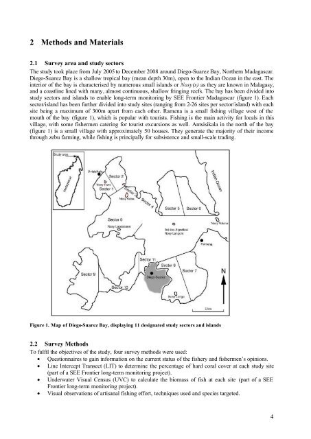
<strong>Diego</strong>-<strong>Suarez</strong> <strong>Bay</strong> is a shallow tropical bay (mean depth 30m), open to the Indian Ocean <strong>in</strong> the east. The<br />
<strong>in</strong>terior <strong>of</strong> the bay is characterised by numerous small islands or Nosy(s) as they are known <strong>in</strong> Malagasy,<br />
and a coastl<strong>in</strong>e l<strong>in</strong>ed with many, almost cont<strong>in</strong>uous, shallow fr<strong>in</strong>g<strong>in</strong>g reefs. The bay has been divided <strong>in</strong>to<br />
study sectors and islands to enable long-term monitor<strong>in</strong>g by SEE Frontier <strong>Madagascar</strong> (figure 1). Each<br />
sector/island has been further divided <strong>in</strong>to study sites (rang<strong>in</strong>g from 2-26 sites per sector/island) with each<br />
site be<strong>in</strong>g a maximum <strong>of</strong> 300m apart from each other. Ramena is a small fish<strong>in</strong>g village west <strong>of</strong> the<br />
mouth <strong>of</strong> the bay (figure 1), which is popular with tourists. Fish<strong>in</strong>g is the ma<strong>in</strong> activity for <strong>local</strong>s <strong>in</strong> this<br />
village, with some fishermen cater<strong>in</strong>g for tourist excursions as well. <strong>An</strong>tsisikala <strong>in</strong> the north <strong>of</strong> the bay<br />
(figure 1) is a small village with approximately 50 houses. They generate the majority <strong>of</strong> their <strong>in</strong>come<br />
through zebu farm<strong>in</strong>g, while fish<strong>in</strong>g is pr<strong>in</strong>cipally for subsistence and small-scale trad<strong>in</strong>g.<br />
Figure 1. Map <strong>of</strong> <strong>Diego</strong>-<strong>Suarez</strong> <strong>Bay</strong>, display<strong>in</strong>g 11 designated study sectors and islands<br />
2.2 Survey Methods<br />
To fulfil the objectives <strong>of</strong> the study, four survey methods were used:<br />
• Questionnaires to ga<strong>in</strong> <strong>in</strong>formation on the current status <strong>of</strong> the fishery and fishermen’s op<strong>in</strong>ions.<br />
• L<strong>in</strong>e Intercept Transect (LIT) to determ<strong>in</strong>e the percentage <strong>of</strong> hard coral cover at each study site<br />
(part <strong>of</strong> a SEE Frontier long-term monitor<strong>in</strong>g project).<br />
• Underwater Visual Census (UVC) to calculate the biomass <strong>of</strong> fish at each site (part <strong>of</strong> a SEE<br />
Frontier long-term monitor<strong>in</strong>g project).<br />
• Visual observations <strong>of</strong> artisanal fish<strong>in</strong>g effort, techniques used and species targeted.<br />
4