An assessment of local fisheries in Diego-Suarez Bay, Madagascar
An assessment of local fisheries in Diego-Suarez Bay, Madagascar
An assessment of local fisheries in Diego-Suarez Bay, Madagascar

You also want an ePaper? Increase the reach of your titles
YUMPU automatically turns print PDFs into web optimized ePapers that Google loves.
2.2.1 Socio-economic data<br />
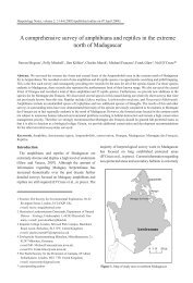
A total <strong>of</strong> 21 fishermen were <strong>in</strong>terviewed from the village <strong>An</strong>tsisikala (figure 1) on two separate<br />
occasions <strong>in</strong> November 2006 and then <strong>in</strong> August 2008 and n<strong>in</strong>eteen fishermen were <strong>in</strong>terviewed <strong>in</strong><br />
Ramena (figure 1) <strong>in</strong> December 2006. The questionnaires consisted <strong>of</strong> 25 questions (Appendix 8.1) and<br />
each <strong>in</strong>terview was conducted us<strong>in</strong>g a Malagasy <strong>in</strong>terpreter last<strong>in</strong>g approximately 40 m<strong>in</strong>utes. Questions<br />
centred on fish<strong>in</strong>g practices, fish<strong>in</strong>g habits, economic considerations, <strong>local</strong> perceptions on fish stocks,<br />
temporal changes and environmental awareness. The estimated catch per unit effort (CPUE) value was<br />
calculated <strong>in</strong> (kg per man/h) us<strong>in</strong>g <strong>in</strong>formation on catch weight and time-spent fish<strong>in</strong>g for each type <strong>of</strong><br />
equipment.<br />
2.2.2 Resource status<br />
The L<strong>in</strong>e Intercept Transect (LIT) method was used to calculate percentage cover <strong>of</strong> hard coral genera at<br />
a given survey site. The length <strong>of</strong> each benthic substratum, found directly underneath a 20m transect l<strong>in</strong>e<br />
was recorded (<strong>in</strong> cms). If the substrate was hard coral, it was recorded to genus level. Data collected us<strong>in</strong>g<br />
the LIT method was collected between July 2005 and September 2008. Spearman’s rank correlations<br />
were calculated to determ<strong>in</strong>e relationships between fish<strong>in</strong>g activity and fish biomass, fish diversity and<br />
hard coral cover.<br />
To assess fish species diversity and biomass at a given survey site the Underwater Visual Census (UVC)<br />
technique was used. The size and frequency <strong>of</strong> fish encountered with<strong>in</strong> an area 2.5 m on either side and 5<br />
m above a 20m transect was recorded. The size <strong>of</strong> any fish enter<strong>in</strong>g this space was estimated to the<br />
nearest 5cm and recorded on a specially designed slate. Species recorded were <strong>in</strong> the families: Lethr<strong>in</strong>idae<br />
(emperors), Lutjanidae (snappers), Labridae (wrasse), Serranidae (groupers), Mullidae (goatfish),<br />
Siganidae (rabbitfish), Haemulidae (sweetlips), Balistidae (triggerfish, Acanthuridae (surgeonfish),<br />
Carangidae (jacks and trevallies), Dasyatidae (st<strong>in</strong>grays), Holocentridae (squirrelfish and soliderfish),<br />
Apogonidae (card<strong>in</strong>alfish), Caesionidae (fusiliers), Nemipteridae (monocle breams and sp<strong>in</strong>e cheeks),<br />
Chaetodontidae (butterflyfish), Pomacanthidae (angelfish), Pomacentridae (damselfish), Scaridae<br />
(parrotfish), Scrombridae, (mackerel) Lethr<strong>in</strong>idae (emperors) and Sphyraenidae (barracuda). Data<br />
collected us<strong>in</strong>g the UVC method is available between July 2005 and December 2008 for all sectors and<br />
islands.<br />
The number <strong>of</strong> LIT and UVC surveys carried out dur<strong>in</strong>g this time <strong>in</strong> each sector or island is as follows;<br />
Nosy Fano=29, Nosy Koba=34, Ramena=8, Nosy Langoro=12, Nosy Loapasana=14, Nosy Volana=5,<br />
Sector 0=63, Sector 1=46, Sector 2=74, Sector 3=67, Sector 4=71, Sector 5=68, Sector 6=22, Sector<br />
7=14, Sector 8=19, Sector 9=2, Sector 10=4, Sector 11=9 (a total <strong>of</strong> 561). Dur<strong>in</strong>g January to December<br />
2008 the follow<strong>in</strong>g number <strong>of</strong> surveys were carried out; Nosy Fano =12, Nosy Koba=22, Nosy<br />
Langoro=6, Sector 0=21, Sector 1=15, Sector 2=32, Sector 3=33, Sector 4=21, Sector 5=12 (a total <strong>of</strong><br />
175). See Frontier-<strong>Madagascar</strong> (2003) for more details on the LIT and UVC methods.<br />
2.2.3 Visual Observations<br />
Dur<strong>in</strong>g UVC and LIT surveys, systematic observations were made concern<strong>in</strong>g levels <strong>of</strong> coral damage<br />
caused by fish<strong>in</strong>g activity, fish species caught <strong>in</strong> nets or on l<strong>in</strong>es by fishermen, types <strong>of</strong> gear used and<br />
materials, number <strong>of</strong> fishers <strong>in</strong>volved <strong>in</strong> fish<strong>in</strong>g activities, plus any additional relevant <strong>in</strong>formation<br />
observed dur<strong>in</strong>g fish<strong>in</strong>g activity. The presence and number <strong>of</strong> fish<strong>in</strong>g boats was also noted at each site<br />
before and after the UVC and LIT surveys were performed. Data was collected between July 2005 and<br />
December 2008 for all sectors and islands. <strong>An</strong> estimated CPUE value was calculated <strong>in</strong> (kg per man/h) on<br />
observations made dur<strong>in</strong>g fish<strong>in</strong>g activity. Us<strong>in</strong>g mean weight <strong>of</strong> catch, gear used and time spent fish<strong>in</strong>g<br />
per day, where available from the questionnaires or observed dur<strong>in</strong>g fish<strong>in</strong>g activity, an estimated CPUE<br />
value has been calculated.<br />
5