Application 124771 - Ministry of Fisheries
Application 124771 - Ministry of Fisheries
Application 124771 - Ministry of Fisheries

You also want an ePaper? Increase the reach of your titles
YUMPU automatically turns print PDFs into web optimized ePapers that Google loves.
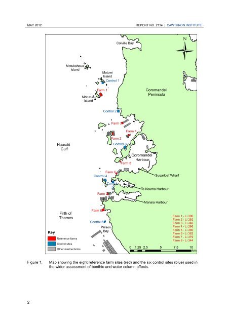
MAY 2012 REPORT NO. 2134 | CAWTHRON INSTITUTE<br />
2<br />
Key<br />
Hauraki<br />
Gulf<br />
Firth <strong>of</strong><br />
Thames<br />
Reference farms<br />
Control sites<br />
Motukahaua<br />
Island<br />
Other marine farms<br />
Moturua<br />
Island<br />
Farm 1<br />
Farm 3<br />
Farm 6<br />
Control 4<br />
Farm 8<br />
Motuwi<br />
Island<br />
Control 1<br />
Farm 7<br />
Control 2<br />
Control 6<br />
Wilson<br />
Bay<br />
Farm 2<br />
Control 3<br />
Control<br />
5<br />
Colville Bay<br />
Farm 5<br />
Farm 4<br />
Coromandel<br />
Harbour<br />
Coromandel<br />
Peninsula<br />
Sugarloaf Wharf<br />
Te Kouma Harbour<br />
Manaia Harbour<br />
Ü<br />
Farm 1 - Li 396<br />
Farm 2 - Li 292<br />
Farm 3 - Li 346<br />
Farm 4 - Li 296<br />
Farm 5 - Li 380<br />
Farm 6 - Li 362<br />
Farm 7 - Li 379<br />
Farm 8 - Li 344<br />
0 1.25 2.5 5 7.5 10<br />
km<br />
Figure 1. Map showing the eight reference farm sites (red) and the six control sites (blue) used in<br />
the wider assessment <strong>of</strong> benthic and water column effects.