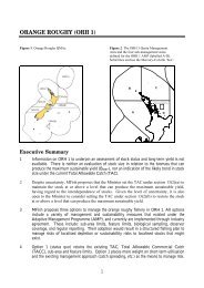
Application 124771 - Ministry of Fisheries
Application 124771 - Ministry of Fisheries
Application 124771 - Ministry of Fisheries

Create successful ePaper yourself
Turn your PDF publications into a flip-book with our unique Google optimized e-Paper software.
6<br />
2011) identified that the aquaculture industry contributed $31.4 million to<br />
Waikato’s regional GDP in 2010/11. In respect <strong>of</strong> this application, potential socioeconomic<br />
effects include employment opportunities from managing, transporting<br />
and processing additional product.<br />
4.2.3 The applicant would continue to utilise their existing land-based facilities and<br />
support infrastructure associated with the existing consented farm. The applicant<br />
considers these facilities to be sufficient and adequate to service the proposed<br />
one hectare extension.<br />
4.2.4 In terms <strong>of</strong> socio-economic impacts on other parties, the extension to the farm<br />
would contribute to the recreational fishing opportunities for boating fishers near<br />
the farm. It is currently common practice for recreational fishers to tie up to<br />
mussel buoys and fish within the farmed areas. Public access to the farm would<br />
not be restricted.<br />
4.2.5 In respect <strong>of</strong> cultural effects it is considered that the extension would have no<br />
impacts on cultural matters. The applicant is not aware that the site <strong>of</strong> the<br />
extension is <strong>of</strong> any significance to tangata whenua. To the knowledge <strong>of</strong> the<br />
applicant, no cultural issues have been raised in relation to farming in this area.<br />
4.3 Any physical effect on the locality, including any landscape and visual effects<br />
Landscape and Visual Effects<br />
4.3.1 The proposed farm extension is located on the northern and western edges <strong>of</strong> the<br />
existing farm. The extension is at its closest boundary approximately (but no<br />
closer than) 50 metres from shore. The visual impact <strong>of</strong> the additional one<br />
hectare over and above the impact <strong>of</strong> the existing farm is considered to be less<br />
than minor. There are no dwellings overlooking the existing farm.<br />
4.3.2 The farm is located <strong>of</strong>fshore from Moturua Island. The natural character <strong>of</strong> the<br />
area is already altered by the presence <strong>of</strong> the existing 3 farms. Moturua Island is<br />
uninhabited and is primarily bush clad. The proposed additional one hectare<br />
would have minimal additional impact on the natural character <strong>of</strong> the area due to<br />
the small size <strong>of</strong> the extension and the distance <strong>of</strong>f-shore. In addition the visibility<br />
<strong>of</strong> the buoys is only a smaller proportion <strong>of</strong> the overall surface area <strong>of</strong> the farm<br />
due to the requirement to accommodate the anchor warps (which are beneath<br />
the water line).<br />
4.3.3 The plan requires orange buoys to delineate the farms (corners and middle <strong>of</strong> the<br />
most seaward and most landward lines). This not only identifies each farm block<br />
but it also has a significant safety role, as it serves to warn other users <strong>of</strong> the<br />
marine environment <strong>of</strong> the farm boundaries. Therefore although bright in colour,<br />
these buoys serve as an extra navigational aid for other marine users.<br />
6