Application 124771 - Ministry of Fisheries
Application 124771 - Ministry of Fisheries
Application 124771 - Ministry of Fisheries

You also want an ePaper? Increase the reach of your titles
YUMPU automatically turns print PDFs into web optimized ePapers that Google loves.
CAWTHRON INSTITUTE | REPORT NO. 2167 MAY 2012<br />
1. SURVEY SUMMARY<br />
A benthic assessment was commissioned by Gold Ridge Marine Farm Limited and<br />
carried out by the Cawthron Institute (Cawthron) on 14 December 2011, within and<br />
adjacent to a proposed 1 ha extension at Li 373, SO 56415.<br />
1.1. Current farm layout<br />
A consent for Li 373, a 6 ha green-lipped mussel (Perna canaliculus) farm, was issued<br />
in 1987 and the farm was installed over the following 10 years. It has been used<br />
exclusively for this purpose since that date.<br />
Li 373 lies to the east <strong>of</strong> Moturua Island, to the north <strong>of</strong> the Coromandel Harbour and<br />
16 km from the Coromandel Harbour / Sugarloaf Wharf at Te Kouma (Figure 1). The<br />
farm is at depths ranging between 14-30 m. It is no closer than 45 m from the shore<br />
and is situated adjacent to mussel farms, Li 396 and Li 361.<br />
25m<br />
30m 35m<br />
45m from<br />
shore<br />
Moturua Island<br />
Li373<br />
Stocking<br />
density<br />
= 11 lines<br />
5m 10m 15m<br />
Li396<br />
0 37.5 75 150 225 300<br />
m<br />
20m<br />
Li396<br />
±<br />
Li361 Li361<br />
Moturuhi<br />
Is.<br />
Moturua<br />
Is.<br />
30m<br />
Li373 current farm area<br />
Li361 & 396 current farm areas<br />
Li373 currently consented area<br />
Li373 farm extension<br />
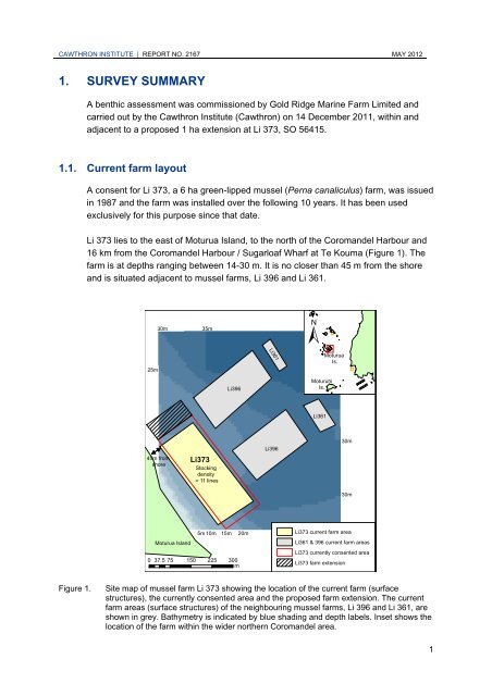
Figure 1. Site map <strong>of</strong> mussel farm Li 373 showing the location <strong>of</strong> the current farm (surface<br />
structures), the currently consented area and the proposed farm extension. The current<br />
farm areas (surface structures) <strong>of</strong> the neighbouring mussel farms, Li 396 and Li 361, are<br />
shown in grey. Bathymetry is indicated by blue shading and depth labels. Inset shows the<br />
location <strong>of</strong> the farm within the wider northern Coromandel area.<br />
30m<br />
1