

Native Vegetation Precinct Plan - City of Greater Geelong
Native Vegetation Precinct Plan - City of Greater Geelong
Native Vegetation Precinct Plan - City of Greater Geelong

You also want an ePaper? Increase the reach of your titles
YUMPU automatically turns print PDFs into web optimized ePapers that Google loves.
Construction Easements are as follows<br />
- 50m at culvert crossings<br />
- 5m along roadsides that front onto a reserve<br />
- 10m at main road intersections<br />
- 15m at wetlands<br />
Figure 1.1<br />
Figure 1.2<br />
Figure 1.3<br />
Figure 1.4<br />
Figure 1.5<br />
Figure 1.6<br />
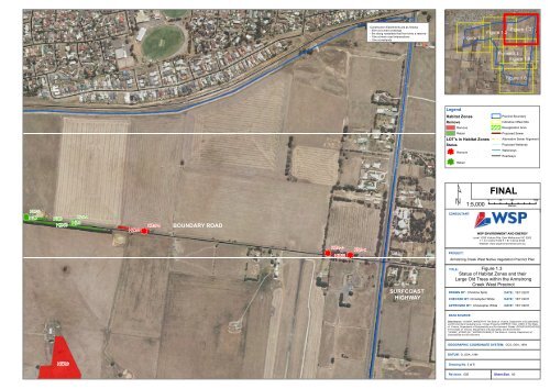
Legend<br />
Habitat Zones<br />
Remove<br />
Remove<br />
Retain<br />
LOT's in Habitat Zones<br />
Status<br />
nm Remove<br />
<strong>Precinct</strong> Boundary<br />
Indicative Offset Site<br />
Revegetation Area<br />
Proposed Sewer<br />
Alternative Sewer Alignment<br />
Proposed Wetlands<br />
Waterways<br />
Roadways<br />
nm Retain<br />
¹<br />
1:5,000<br />
FINAL<br />
0 45 90 180<br />
Metres<br />
nmnmnm nm<br />
HZ7-b<br />
HZ7<br />
HZ8<br />
HZ46<br />
HZ9-a<br />
HZ9<br />
nm<br />
HZ10<br />
nm<br />
HZ10-b<br />
BOUNDARY ROAD<br />
nm<br />
HZ11-c<br />
HZ11<br />
nm<br />
HZ11-a<br />
CONSULTANT:<br />
WSP ENVIRONMENT AND ENERGY<br />
Level 1/250 Victoria Pde, East Melbourne VIC 3002<br />
T + 61 3 9412 5100 F + 61 3 9412 5199<br />
Website: www.wspenvironmental.com.au<br />
PROJECT:<br />
Armstrong Creek West <strong>Native</strong> <strong>Vegetation</strong> <strong>Precinct</strong> <strong>Plan</strong><br />
SURFCOAST<br />
HIGHWAY<br />
Figure 1.3<br />
Status <strong>of</strong> Habitat Zones and their<br />
Large Old Trees within the Armstrong<br />
Creek West <strong>Precinct</strong><br />
TITLE:<br />
DRAWN BY: Christine Spits<br />
CHECKED BY: Christopher White<br />
DATE: 15/11/2011<br />
DATE: 15/11/2011<br />
APPROVED BY: Christopher White<br />
DATE: 15/11/2011<br />
DATA SOURCE:<br />
Data Source: ‘VICMAP_IMAGERY’© The State <strong>of</strong> Victoria, Department <strong>of</strong> Sustainability<br />
and Environment Cadastral Line- Vicmap Property (VMPROP_CAD_LINE/) © The State<br />
<strong>of</strong> Victoria, Department <strong>of</strong> Sustainability and Environment. Roads- (ROAD100/ROAD100)<br />
© The State <strong>of</strong> Victoria, Department <strong>of</strong> Sustainability and Environment.<br />
‘VICMAP_HYDRO (HY_WATERCOURSE) © The State <strong>of</strong> Victoria, Department <strong>of</strong><br />
Sustainability and Environment<br />
GEOGRAPHIC COORDINATE SYSTEM: GCS_GDA_1994<br />
DATUM: D_GDA_1994<br />
HZ26<br />
Drawing No. 3 <strong>of</strong> 6<br />
nm<br />
Revision. 005<br />
Sheet Size. A3


