Green Infrastructure to Combat Climate Change: A Framework for ...
Green Infrastructure to Combat Climate Change: A Framework for ...
Green Infrastructure to Combat Climate Change: A Framework for ...

You also want an ePaper? Increase the reach of your titles
YUMPU automatically turns print PDFs into web optimized ePapers that Google loves.
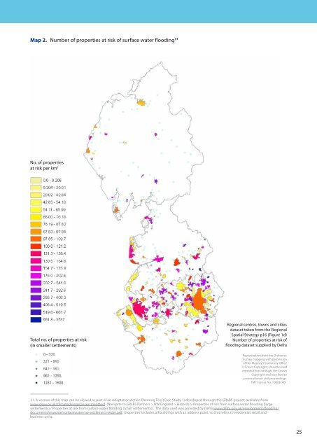
Map 2. Number of properties at risk of surface water flooding 31<br />
No. of properties<br />
at risk per km 2<br />
Total no. of properties at risk<br />
(in smaller settlements)<br />
Regional centres, <strong>to</strong>wns and cities<br />
dataset taken from the Regional<br />
Spatial Strategy p16 (Figure 1d)<br />
Number of properties at risk of<br />
flooding dataset supplied by Defra<br />
Reproduction from the Ordnance<br />
Survey mapping with permission<br />
of Her Majesty’s Stationery Office<br />
© Crown Copyright. Unauthorised<br />
reproduction infringes the Crown<br />
Copyright and may lead <strong>to</strong><br />
prosecution or civil proceedings.<br />
TMF license No. 100031461<br />
31. A version of this map can be viewed as part of an Adaptation Action Planning Tool (Case Study 1) developed through the GRaBS project; available from<br />
www.ginw.co.uk/climatechange/assessment<strong>to</strong>ol. (Navigate <strong>to</strong> GRaBS Partners > NW England > Hazards > Properties at risk from surface water flooding (large<br />
settlements) / Properties at risk from surface water flooding (small settlements)). The data used was provided by Defra www.defra.gov.uk/environment/flooding/<br />
documents/manage/surfacewater/sw-settlement-order.pdf; ‘properties’ includes all buildings with an address point, so this refers <strong>to</strong> residential, retail and<br />
business units.<br />
25