Green Infrastructure to Combat Climate Change: A Framework for ...
Green Infrastructure to Combat Climate Change: A Framework for ...
Green Infrastructure to Combat Climate Change: A Framework for ...

You also want an ePaper? Increase the reach of your titles
YUMPU automatically turns print PDFs into web optimized ePapers that Google loves.
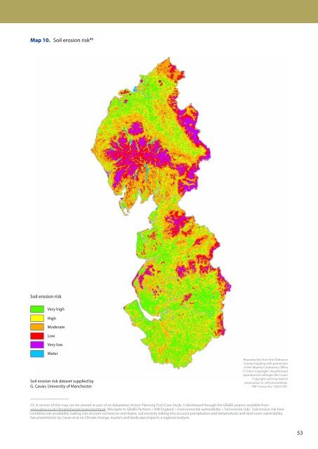
Map 10. Soil erosion risk 53<br />
Soil erosion risk<br />
Very high<br />
High<br />
Moderate<br />
Low<br />
Very low<br />
Water<br />
Soil erosion risk dataset supplied by<br />
G. Cavan, University of Manchester<br />
Reproduction from the Ordnance<br />
Survey mapping with permission<br />
of Her Majesty’s Stationery Office<br />
© Crown Copyright. Unauthorised<br />
reproduction infringes the Crown<br />
Copyright and may lead <strong>to</strong><br />
prosecution or civil proceedings.<br />
TMF license No. 100031461<br />
53. A version of this map can be viewed as part of an Adaptation Action Planning Tool (Case Study 1) developed through the GRaBS project; available from<br />
www.ginw.co.uk/climatechange/assessment<strong>to</strong>ol. (Navigate <strong>to</strong> GRaBS Partners > NW England > Environmental vulnerability > Soil erosion risk). Soil erosion risk here<br />
combines soil erodability (taking in<strong>to</strong> account soil texture and slope), soil erosivity (taking in<strong>to</strong> account precipitation and temperature) and land cover vulnerability.<br />
See presentation by Cavan et al on <strong>Climate</strong> change, <strong>to</strong>urism and landscape impacts: a regional analysis.<br />
53