Green Infrastructure to Combat Climate Change: A Framework for ...
Green Infrastructure to Combat Climate Change: A Framework for ...
Green Infrastructure to Combat Climate Change: A Framework for ...

Create successful ePaper yourself
Turn your PDF publications into a flip-book with our unique Google optimized e-Paper software.
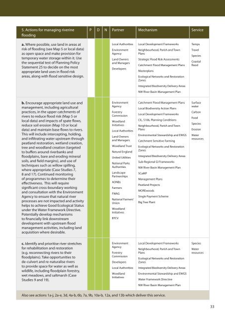
5. Actions <strong>for</strong> managing riverine<br />
flooding<br />
P D N Partner Mechanism Service<br />
a. Where possible, use land in areas at<br />
risk of flooding (see Map 5 or local data)<br />
as open space and make provision <strong>for</strong><br />
temporary water s<strong>to</strong>rage within it. Use<br />
the sequential test of Planning Policy<br />
Statement 25 <strong>to</strong> decide on the most<br />
appropriate land uses in flood risk<br />
areas, along with flood sensitive design.<br />
Local Authorities<br />
Environment<br />
Agency<br />
Land Owners<br />
and Managers<br />
Developers<br />
Local Development <strong>Framework</strong>s<br />
Neighbourhood, Parish and Town<br />
Plans<br />
Strategic Flood Risk Assessments<br />
Catchment Flood Management Plans<br />
Masterplans<br />
Ecological Networks and Res<strong>to</strong>ration<br />
Zones<br />
Temps<br />
Travel<br />
Species<br />
Coastal<br />
flood<br />
Integrated Biodiversity Delivery Areas<br />
NW River Basin Management Plan<br />
b. Encourage appropriate land use and<br />
management, including agricultural<br />
practices, in the upper catchments of<br />
rivers <strong>to</strong> reduce flood risk (Map 5 or<br />
local data) and impacts of spate flows,<br />
reduce soil erosion (Map 10 or local<br />
data) and maintain base flows <strong>to</strong> rivers.<br />
This will include intercepting, holding,<br />
and infiltrating water upstream through<br />
peatland res<strong>to</strong>ration, wetland creation,<br />
tree and woodland creation (targeted<br />
<strong>to</strong> buffers around riverbanks and<br />
floodplains, bare and eroding mineral<br />
soils, and field margins), and use of<br />
techniques such as willow spilling,<br />
where appropriate (Case Studies 7,<br />
8 and 17). Continued moni<strong>to</strong>ring<br />
of programmes <strong>to</strong> determine their<br />
effectiveness. This will require<br />
significant cross-boundary working<br />
and consultation with the Environment<br />
Agency <strong>to</strong> ensure that natural river<br />
processes are not impacted and activity<br />
helps <strong>to</strong> achieve Good Ecological Status<br />
under the Water <strong>Framework</strong> Directive.<br />
Potentially develop mechanisms<br />
<strong>to</strong> financially link downstream<br />
development with upstream flood<br />
management activities, including land<br />
acquisition where desirable.<br />
Environment<br />
Agency<br />
Forestry<br />
Commission<br />
Woodland<br />
Initiatives<br />
Local Authorities<br />
Land Owners<br />
and Managers<br />
Woodland Trust<br />
Natural England<br />
United Utilities<br />
National Parks<br />
Authorities<br />
Landscape<br />
Partnerships<br />
AONBs<br />
Farmers<br />
FWAG<br />
National Farmers’<br />
Union<br />
Woodland<br />
Initiatives<br />
BTCV<br />
Catchment Flood Management Plans<br />
Local Biodiversity Action Plans<br />
Local Development <strong>Framework</strong>s<br />
CIL, S106, Planning Conditions<br />
Neighbourhood, Parish and Town<br />
Plans<br />
Environmental Stewardship and EWGS<br />
Catchment Sensitive Farming<br />
Ecological Networks and Res<strong>to</strong>ration<br />
Zones<br />
Integrated Biodiversity Delivery Areas<br />
Sub-Regional GI <strong>Framework</strong>s<br />
NW River Basin Management Plan<br />
SCaMP<br />
Management Plans<br />
Peatland Projects<br />
MOREwoods<br />
Single Payment Scheme<br />
Big Tree Plant<br />
Surface<br />
water<br />
Carbon<br />
Food<br />
Species<br />
Erosion<br />
Water<br />
resources<br />
c. Identify and prioritise river stretches<br />
<strong>for</strong> rehabilitation and res<strong>to</strong>ration<br />
(e.g. reconnecting rivers <strong>to</strong> their<br />
floodplains). Take opportunities <strong>to</strong><br />
de-culvert and re-naturalise rivers<br />
<strong>to</strong> provide space <strong>for</strong> water as well as<br />
wildlife, including floodplain <strong>for</strong>estry,<br />
wet meadows, and saltmarsh (Case<br />
Studies 9 and 19).<br />
Environment<br />
Agency<br />
Forestry<br />
Commission<br />
Developers<br />
Local Authorities<br />
Woodland<br />
Initiatives<br />
Local Development <strong>Framework</strong>s<br />
Neighbourhood, Parish and Town<br />
Plans<br />
Ecological Networks and Res<strong>to</strong>ration<br />
Zones<br />
Integrated Biodiversity Delivery Areas<br />
Environmental Stewardship and EWGS<br />
Water <strong>Framework</strong> Directive<br />
Species<br />
Water<br />
resources<br />
NW River Basin Management Plan<br />
Also see actions 1a-j, 2a-e, 3d, 4a-b, 6b, 7a, 9b, 10a-b, 12a, and 13b which deliver this service.<br />
33