Draft Records Review Report - Invenergy
Draft Records Review Report - Invenergy
Draft Records Review Report - Invenergy

Create successful ePaper yourself
Turn your PDF publications into a flip-book with our unique Google optimized e-Paper software.
HIGHWAY 23<br />
HIGHWAY 23<br />
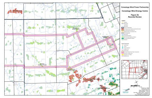
Conestogo Wind Power Partnership<br />
Dorking North Woodlot<br />
Conestogo Wind Energy Centre<br />
Figure 3b<br />
<strong>Records</strong> <strong>Review</strong><br />
Kirkland Creek<br />
Wetland Complex<br />
Conestogo River<br />
Wetland 1<br />
Legend<br />
Highway<br />
Major Road<br />
Local Road<br />
Water Body<br />
Upper Tier Municipality<br />
Life Science Area of Natural and Scientific Interest<br />
Deer Wintering Area (Stratum 2)<br />
Waterfowl Winter Concentration Area<br />
Mineral Aggregate<br />
Water Body<br />
Unevaluated Wetland<br />
Non-Provincially Significant Wetland<br />
Provincially Significant Wetland<br />
Woodland<br />
!(<br />
Project Components<br />
")Ð Junction Box<br />
A<br />
!(<br />
Turbine<br />
Project Substation<br />
Collector Line<br />
Access Road<br />
120 metre Setback from Project Components<br />
Temporary Laydown Area<br />
Temporary Turn Radius<br />
Buildable Area<br />
Nith River<br />
Headwater Complex<br />
Crosshill Moraine<br />
Wetland Complex 1<br />
Map A<br />
Map B<br />
HIGHWAY 7 & 8<br />
Crosshill Complex<br />
St. Clements Sphagnum Bog<br />
/<br />
1:60,000<br />
34 LINE<br />
Bamberg Swamp and Bog Lake<br />
0 0.5 1 1.5 km<br />
Created by: GSM<br />
Checked By: DR<br />
Date Created: 040512<br />
Date Modified: 111512<br />
File Path: I:\GIS\114472 - Gotham\<br />
Mapping\Site Investigation\<br />
Figure 3b <strong>Records</strong> <strong>Review</strong>.mxd