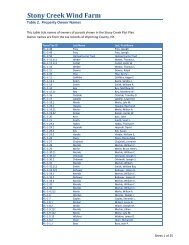
Draft Records Review Report - Invenergy
Draft Records Review Report - Invenergy
Draft Records Review Report - Invenergy

Create successful ePaper yourself
Turn your PDF publications into a flip-book with our unique Google optimized e-Paper software.
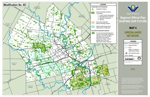
Modification No. 65<br />
COUNTY RD 86 TO LISTOWEL<br />
County of<br />
Wellington<br />
LEGEND<br />
Landscape Level Systems<br />
Significant Valleys<br />
LINE 86<br />
Grand<br />
River<br />
HWY 7 TO GUELPH<br />
HWY 401 TO TORONTO<br />
HWY 7/8 TO STRATFORD<br />
Nith River<br />
FLORADALE RD<br />
ART HUR ST<br />
NORT HFIELD DR<br />
County of<br />
Wellington<br />
Environmentally Sensitive<br />
Landscape<br />
1. Laurel Creek Headwaters<br />
2. Blair-Bechtel-Cruickston<br />
3. Dumfries Carolinian<br />
4. Beverly<br />
County of<br />
Perth<br />
PERTH LINE<br />
County of<br />
Perth<br />
WILLIAM HASTIN GS LINE<br />
HUTCH ISON RD<br />
WILMOT-EAST HOPE RD<br />
MAN SER RD<br />
NAF ZIGER RD<br />
GERBER RD<br />
Township of<br />
Wellesley<br />
1.<br />
AMENT LINE<br />
WEIMAR LINE<br />
HER RGOTT RD<br />
NOT RE DAME DR<br />
Township of<br />
Wilmot<br />
!.<br />
ERB'S R D<br />
KRESSLER RD<br />
SNYDER'S RD EAST<br />
Conestogo River<br />
HWY 7/8<br />
LOBSINGER LINE<br />
LISTOWEL RD<br />
HAWKESVILLE RD<br />
!.<br />
ART HUR ST<br />
!.<br />
!.<br />
!.<br />
LINE 86<br />
!.<br />
!.<br />
!.<br />
!.<br />
Grand River<br />
!.<br />
KAT HER INE ST<br />
SAWMILL RD<br />
BLOOMINGDALE RD N<br />
!.<br />
!.<br />
!.<br />
!.<br />
Township of<br />
Woolwich<br />
!.<br />
ST CHARLES ST<br />
EBYCREST RD<br />
!.<br />
FOUNTAIN ST<br />
!.<br />
!.<br />
HWY 7<br />
!.<br />
SHANT Z STATION R D<br />
MAPLE GROVE R D<br />
KOSSU TH R D<br />
Speed River<br />
2.<br />
!.<br />
!.<br />
!.<br />
Core Environmental Features<br />
include: Provincially Significant<br />
Wetlands; Environmentally<br />
Sensitive Policy Areas;<br />
Regional Forests;<br />
City<br />
Forests<br />
of<br />
greater than 4<br />
Guelph<br />
ha; and<br />
Significant Valley Features<br />
TOWN LINE RD<br />
Provincial Greenbelt<br />
Natural Heritage System<br />
Regional Recharge Areas<br />
(also shown on Map 6g)<br />
Core Environmental Features<br />
4.<br />
MAP 4<br />
GREENLANDS<br />
NETWORK<br />
!.<br />
LEGEND<br />
Provincial Highway<br />
Regional Road<br />
River<br />
Region of Waterloo<br />
International Airport<br />
Municipal Boundary<br />
Railway<br />
0 1 2 4<br />
Km<br />
°<br />
Sources: Region of Waterloo, Ministry of<br />
Natural Resources<br />
BLEAM S RD<br />
QUEEN ST<br />
TRUSSLER RD<br />
!.<br />
FO<br />
UNTAIN ST<br />
BLAIR RD<br />
CLYDE RD<br />
OLD BEVER LY RD<br />
2010<br />
NEW DUNDEE RD<br />
WALKER RD<br />
BRIDGE ST<br />
ROSEVILLE RD<br />
CED AR CREEK RD<br />
NORT HUMBERLAN D ST<br />
DUMFRIES RD<br />
County of<br />
Oxford<br />
OXFORD-WATERLOO RD<br />
HWY 401 TO LONDON<br />
Nith River<br />
!.<br />
SWAN ST<br />
HWY 401<br />
WRIGLEY RD<br />
Township of<br />
North<br />
Dumfries<br />
!.<br />
SPRAGUES RD<br />
Gra nd River<br />
BRANTFORD HW Y (HWY 24)<br />
HWY 24 TO BRANTFORD<br />
3.<br />
BRANC HTON RD<br />
HWY 8 TO HAMILTON<br />
City of<br />
Hamilton<br />
Note: As of January 24, 2011, this Plan in its entirety,<br />
is currently under appeal before the Ontario Municipal<br />
Board (OMB). Before using this document, care should<br />
be taken to check the updated status of the appeal<br />
process on the Region of Waterloo's website.<br />
Note: Permanent and intermittent watercourses are<br />
identified in the Technical Appendix for Landscape Level<br />
Systems and Core Environmental Features.<br />
Note: This map forms part of the Official Plan of the<br />
Regional Municipality of Waterloo and must be read<br />
in conjunction with the policies of this Plan.