Narrative - City of Phoenix
Narrative - City of Phoenix
Narrative - City of Phoenix

You also want an ePaper? Increase the reach of your titles
YUMPU automatically turns print PDFs into web optimized ePapers that Google loves.
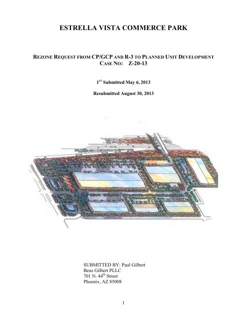
ESTRELLA VISTA COMMERCE PARK<br />
REZONE REQUEST FROM CP/GCP AND R-3 TO PLANNED UNIT DEVELOPMENT<br />
CASE NO: Z-20-13<br />
1 ST Submitted May 6, 2013<br />
Resubmitted August 30, 2013<br />
SUBMITTED BY: Paul Gilbert<br />
Beus Gilbert PLLC<br />
701 N. 44 th Street<br />
<strong>Phoenix</strong>, AZ 85008<br />
1
PRINCIPALS AND DEVELOPMENT TEAM<br />
APPLICANT REPRESENTATIVE/LEGAL:<br />
Beus Gilbert PLLC<br />
Paul E. Gilbert<br />
Neal T. Pascoe<br />
701 N. 44 th Street<br />
<strong>Phoenix</strong>, AZ 85008<br />
Telephone: 480-429-3002 / 480-429-3060<br />
Facsimile: (480) 429-3100<br />
E-mail: pgilbert@beusgilbert.com<br />
npascoe@beusgilbert.com<br />
OWNER:<br />
Estrella Vista Commerce Park LLC<br />
745 E. Maryland Avenue Suite 100<br />
<strong>Phoenix</strong> AZ 85014<br />
Telephone: (602) 279-2808<br />
E-mail: ipasternack@pasternack.net<br />
ARCHITECT/PLANNING & LANDSCAPE ARCHITECTURE<br />
Irwin G. Pasternack AIA &<br />
Associates, PC<br />
745 E. Maryland Avenue Suite 100<br />
<strong>Phoenix</strong>, AZ 85014<br />
Telephone: (602) 279-2808<br />
Facsimile: (602) 277-5978<br />
E-mail: dpresto@pasternack.net<br />
2
TRAFFIC ENGINEERING:<br />
Dawn Cartier<br />
CivTech<br />
10605 North Hayden Road<br />
Scottsdale, AZ 85260<br />
Telephone: (480) 659-4250<br />
E-mail: dcartier@civtech.com<br />
CIVIL ENGINEERING:<br />
Jay Mihalek<br />
JMA Engineering Corporation<br />
531 E. Bethany Home Road<br />
Garden Suite<br />
<strong>Phoenix</strong>, AZ 85012<br />
Telephone: 602 248 0286<br />
E-mail: Jay@jmaengineering.com<br />
3
PLANNED UNIT DEVELOPMENT DISCLAIMER<br />
A Planned Unit Development (PUD) is intended to be a stand-alone document <strong>of</strong> zoning<br />
regulations for a particular project. Provisions not specifically regulated by the PUD are<br />
governed by the zoning ordinance. A PUD may include substantial background information to<br />
help illustrate the intent <strong>of</strong> the development. The purpose and intent statements are not<br />
requirements that will be enforced by the <strong>City</strong>. The PUD only modifies zoning ordinance<br />
regulations and does not modify other <strong>City</strong> Codes or requirements. Additional public hearings<br />
may be necessary such as, but not limited, to right-<strong>of</strong>-way abandonments.<br />
4
TABLE OF CONTENTS<br />
PAGE<br />
NARRATIVE<br />
Cover Page ................................................................................................................................. 1<br />
Principals and Development Team ................................................................................................. 2<br />
Planned Unit Development Disclaimer .......................................................................................... 4<br />
A. Purpose and Intent............................................................................................................... 7<br />
Project Overview and Goals ............................................................................................... 7<br />
Overall Design Concept ...................................................................................................... 7<br />
B. Land Use Plan ..................................................................................................................... 7<br />
Vehicular Access ................................................................................................................ 7<br />
Landscape Design ............................................................................................................... 8<br />
Use Categories .................................................................................................................... 8<br />
Conceptual Site Plan ........................................................................................................... 9<br />
C. Site Conditions and Location ............................................................................................ 10<br />
Surrounding Land Uses..................................................................................................... 11<br />
Surrounding Zoning Districts ........................................................................................... 11<br />
D. General Plan Conformance ............................................................................................... 11<br />
Growth Area Element ....................................................................................................... 12<br />
Land Use Element ............................................................................................................. 12<br />
Urban Village Model: Neighborhoods ............................................................................. 13<br />
E. Zoning and Land Use Compatibility................................................................................. 13<br />
F. List <strong>of</strong> Uses ....................................................................................................................... 16<br />
G. Development Standards .................................................................................................... 23<br />
Building and Landscape Setbacks .................................................................................... 24<br />
South Perimeter ................................................................................................................. 24<br />
North Perimeter ................................................................................................................. 24<br />
West Perimeter .................................................................................................................. 24<br />
East Perimeter ................................................................................................................... 25<br />
Height ............................................................................................................................... 27<br />
Lot Coverage ..................................................................................................................... 27<br />
Allowed Uses .................................................................................................................... 27<br />
Required Review ............................................................................................................... 27<br />
Landscape Standards ......................................................................................................... 28<br />
Perimeter Property Line Landscaping .............................................................................. 29<br />
Freeway Perimeter Landscaping ....................................................................................... 29<br />
Retention Area Landscaping ............................................................................................. 29<br />
Parking Area Landscaping ................................................................................................ 29<br />
Landscape Materials ......................................................................................................... 30<br />
Parking Standards ............................................................................................................. 30<br />
Shade ............................................................................................................................... 30<br />
5
Lighting Standards ............................................................................................................ 30<br />
H. Design Guidelines ............................................................................................................. 30<br />
I. Signage .............................................................................................................................. 31<br />
J. Sustainability..................................................................................................................... 44<br />
K. Infrastructure ..................................................................................................................... 44<br />
Streets ................................................................................................................................ 44<br />
Grading and Drainage ...................................................................................................... 44<br />
Pedestrian Circulation Plan ............................................................................................... 44<br />
Water & Wastewater Services .......................................................................................... 45<br />
Water Design .................................................................................................................... 45<br />
Wastewater Design ........................................................................................................... 45<br />
L. Phasing Plan ...................................................................................................................... 45<br />
M. Exhibits ............................................................................................................................. 47<br />
Comparative Zoning Standards Table .............................................................................. 47<br />
Legal Description .............................................................................................................. 48<br />
Vicinity Map ..................................................................................................................... 53<br />
General Context Zoning Aerial ......................................................................................... 54<br />
Existing Zoning ................................................................................................................ 55<br />
Proposed Zoning ............................................................................................................... 56<br />
Key Map and Context Photos ........................................................................................... 57<br />
Context Photos .................................................................................................................. 59<br />
General Plan 2002 ............................................................................................................. 88<br />
Conceptual Site Plan ......................................................................................................... 89<br />
Conceptual Elevations ...................................................................................................... 90<br />
Conceptual Landscape Plan .............................................................................................. 93<br />
Thematic Street Cross Sections ........................................................................................ 94<br />
Circulation Plan ................................................................................................................ 95<br />
Sign Plan ........................................................................................................................... 96<br />
Color Palette...................................................................................................................... 98<br />
Phasing Plan ...................................................................................................................... 99<br />
Traffic Study or Statement .............................................................................................. 100<br />
6
A. PURPOSE AND INTENT<br />
Project Overview and Goals<br />
Estrella Vista Commerce Park is a property <strong>of</strong> approximately 85 acres located on the south<br />
side <strong>of</strong> the I-10 Freeway between 67 th and 63 rd Avenues. Its size and freeway orientation result in an<br />
opportunity for infill development that provides substantial employment and generates economic<br />
activity on a large scale. Conceptually, the project will <strong>of</strong>fer retail convenience services along 67 th<br />
Avenue with small to large retail, distribution, warehouse, wholesale, and assembly operations<br />
within the interior. At the same time, this is an infill project with existing residential, school, and<br />
park uses adjacent to the project perimeter. As a consequence the project must be context-sensitive,<br />
providing large buffers, diverting truck traffic away from homes and schools, and providing<br />
pedestrian connectivity where appropriate.<br />
Overall Design Concept<br />
• To promote an aesthetically pleasing campus with appropriate consideration given to<br />
building materials, design and site layout.<br />
• Establish a commerce/ business park with a presence along the I-10 freeway with distribution<br />
facilities and showrooms.<br />
• Respect agreements with surrounding neighborhoods as to buffers, setbacks, street design,<br />
and building height.<br />
• To promote neighborhood stability by diverting truck traffic away from homes and schools,<br />
and by providing pedestrian connections to Sunridge Elementary School and Sunridge Park<br />
• Provide convenience retail services along 67 th Avenue to serve the industrial park, the public,<br />
and the surrounding neighborhoods.<br />
• Provide a significant spatial and landscape buffer between the campus and adjacent<br />
residential districts to reduce any perceived negative impacts between dissimilar land uses.<br />
B. LAND USE PLAN<br />
Vehicular Access<br />
67 th Avenue provides access into the campus at Latham Street and an intersection with<br />
Roosevelt Street. These streets converge at a single interior point as Roosevelt Street realigns north<br />
to the Latham alignment, and Roosevelt Street continues southeast as an exclusively residential<br />
street segment. This creates a buffer between the more intense uses in Estrella Vista Commerce Park<br />
and the residential areas south <strong>of</strong> the Roosevelt alignment. It also diverts truck traffic away from<br />
Sunridge Elementary School and Sunridge Park. The School District has also requested the<br />
developer abandon 63 rd Avenue between Latham and Roosevelt streets to further reduce traffic<br />
adjacent to Sunridge School. The proposed street widths within the PUD are depicted in the<br />
Appendix in the section entitled Thematic Street Cross Sections, and reflect the approved final plat<br />
<strong>of</strong> Estrella Vista Commerce Park.<br />
7
Landscape Design<br />
A key component <strong>of</strong> the site design is to provide a landscape buffer between Estrella Vista<br />
and adjacent homes. The buffer also will <strong>of</strong>fer pedestrian connections to Sunridge School and<br />
Sunridge Park via a sidewalk along the north side <strong>of</strong> Roosevelt Street, helping to maintain a unified<br />
and cohesive neighborhood. In addition to landscaping on the north side <strong>of</strong> Roosevelt Street<br />
resulting from the realignment there will be a 50-foot building and landscape setback imposed along<br />
Roosevelt Street on lots east <strong>of</strong> 66 th Drive. The landscaping and setback will provide a significant<br />
buffer to the homes south <strong>of</strong> Roosevelt Street and a neighborhood amenity. Plant materials will be<br />
indigenous or low water use plants and will contain trees that will, in time, provide shade and a<br />
visual screen from the south.<br />
To the north, adjacent to the I-10 Freeway and Arizona Department <strong>of</strong> Transportation<br />
(“ADOT”) property, a smaller landscape setback is proposed. A tall berm on ADOT property blocks<br />
any view from the freeway. The area in question cannot be seen from outside the site and<br />
landscaping there would be difficult to maintain. In addition, vegetation there would create a<br />
security issue by providing hiding places for unsavory activities.<br />
In the case <strong>of</strong> the internal streets, most <strong>of</strong> the right <strong>of</strong> way is taken by street improvements to<br />
accommodate the expected truck traffic and streetscape planting will be limited.<br />
The concept is to concentrate the landscaping to the south and east where it buffers and<br />
enhances the surrounding residential neighborhood with targeted landscaping on the interior focused<br />
on locations where it can be most effective. These strategies will enhance the livability <strong>of</strong> the<br />
neighborhood while accommodating infill development that <strong>of</strong>fers the public significant financial<br />
benefit in terms <strong>of</strong> jobs and sales taxes.<br />
Use Categories<br />
In general, the uses that will be allowed are based on the C-2 (Intermediate Commercial) and<br />
CP/GCP (Commerce Park General Option) zoning districts. These provide for a broad range <strong>of</strong><br />
retail, service, warehouse, wholesale, and assembly activities. Living Spaces, a furniture showroom<br />
and warehouse facility with a combined floor area <strong>of</strong> approximately 437,000 square feet, will be<br />
located in the interior <strong>of</strong> the project in Phase 1. Phase 1 will also include retail pads along 67 th<br />
Avenue. Future phases will be improved based on the demand for space. It is expected the future<br />
phases will be comprised largely <strong>of</strong> warehouse, wholesale, and distribution facilities. A complete list<br />
<strong>of</strong> permitted uses is reflected on Exhibit F-1.<br />
The conceptual site plan is located on the following page.<br />
8
CONCEPTUAL SITE PLAN<br />
9
C. SITE CONDITIONS AND LOCATION<br />
The site is a vacant parcel <strong>of</strong> approximately 85 net acres. The land is virtually flat, with no<br />
significant topographic features or major watercourses. Estrella Vista is located in the Estrella<br />
Village, and is surrounded by a variety <strong>of</strong> uses including single-family homes, Sunridge School,<br />
Sunridge Park, the I-10 Papago Freeway, Danny’s Car/Truck Wash, and the Flying J Truck Stop.<br />
Exhibit C-1 below illustrates the site location.<br />
EXHIBIT C-1<br />
The site’s relationship to its surroundings is illustrated by the following tables:<br />
10
TABLE C-1<br />
Surrounding Land Uses<br />
North<br />
I-10 Freeway/Multifamily<br />
South (Roosevelt Single family homes<br />
street)<br />
West<br />
Flying J truck stop, Danny’s Truck<br />
Wash<br />
East<br />
Elementary School, Park, Homes<br />
Surrounding Zoning Districts<br />
TABLE C-2<br />
Surrounding Zoning Districts<br />
North<br />
C-2, R4-A<br />
South R 1-6<br />
East R 1-6<br />
West A-1<br />
D. GENERAL PLAN CONFORMANCE<br />
The <strong>City</strong> <strong>of</strong> <strong>Phoenix</strong> General Plan Land Use Designation for the Property is a combination <strong>of</strong><br />
Commercial and Residential 3.5-5, Residential 5-10, and Residential 15+. A General Plan<br />
Amendment seeking a change to Commerce/Business Park will accompany this rezone request. As<br />
set forth in the following subsections, the proposed Planned Unit Development rezone request is<br />
consistent and compatible with many <strong>of</strong> the goals and objectives outlined in the General and Land<br />
Use Plans, as well as the current zoning designation for most <strong>of</strong> the property.<br />
The surrounding properties to the north, south, east and west are designated on the Land Use<br />
Plan as single-family residential (3.5 to 5 dwelling units per acre), multi-family, and industrial as<br />
shown in Table D.1.<br />
11
TABLE D-1<br />
Surrounding Land Use Designations<br />
North Residential 15+<br />
South (<strong>of</strong> Roosevelt Street)<br />
Residential 3.5-5 DUAC<br />
West (Across 67 th Avenue)<br />
Industrial<br />
East<br />
Residential 3.5-5 DUAC<br />
The General Plan recognizes the need to promote strong, healthy neighborhoods and to<br />
preserve their unique character, while encouraging development that is sensitive to the scale and<br />
character <strong>of</strong> the surrounding neighborhoods. Typically, this is accomplished by incorporating<br />
appropriate development standards, such as landscaping, screening and setbacks, to mitigate any<br />
negative impacts where disparate land uses are adjoining. The following outlines the relationship<br />
between the requested rezone change and the <strong>City</strong> <strong>of</strong> <strong>Phoenix</strong> General Plan. The General Plan<br />
Elements seek to promote comprehensive direction for the growth, conservation and development <strong>of</strong><br />
all physical aspects <strong>of</strong> the <strong>City</strong>. The proposed rezone meets or exceeds the following goals outlined<br />
in the General Plan:<br />
Growth Area Element<br />
Goal 1 – Growth: Maintain a high quality <strong>of</strong> life and economically healthy community.<br />
The rezoning request supports a high quality <strong>of</strong> life by supporting a stronger linkage between<br />
existing homes, Sunridge Elementary School, and Sunridge Park. Further, the proposed rezoning<br />
request recognizes the desired scale and land use classification <strong>of</strong> the adjacent residential properties<br />
by utilizing intense buffering techniques, which include sizeable setbacks, extensive landscaping and<br />
perimeter treatment, inward orientation with frontage on Latham Street, and extra deep lots.<br />
The economic health <strong>of</strong> the community is bolstered by the development <strong>of</strong> a new commerce<br />
park with hundreds <strong>of</strong> new jobs and retail sales projected to exceed $ 75,000,000 per year in Phase 1<br />
alone.<br />
Land Use Element<br />
The following outlines the relationship between the requested rezoning, the surrounding land<br />
uses and the <strong>City</strong> <strong>of</strong> <strong>Phoenix</strong> General Land Use Plan Element. “The Land Use Element”<br />
recommends how “<strong>Phoenix</strong> should grow within its boundaries to have a rational urban form (the<br />
urban village model), promote infill and be compatible with its neighbors.” In addition, urban<br />
form and the Village Model are integral to the General Plan and zoning relationship:<br />
Goal 1 – Urban Form: Growth should be structured into a series <strong>of</strong> urban villages<br />
characterized by the five components <strong>of</strong> the urban village model: core, neighborhoods,<br />
community service areas, regional service areas and open space.<br />
12
The Principles:<br />
‣ Promoting the uniqueness <strong>of</strong> each village: celebrating the lifestyle and character, the<br />
unique identity <strong>of</strong> each village with its history, patterns <strong>of</strong> development, types <strong>of</strong> open space,<br />
public facilities, and types <strong>of</strong> development from large lot and rural to mixed-use and urban.<br />
‣ Preserving and enhancing the quality <strong>of</strong> life in each village: protecting the historic<br />
character, unique amenities, open spaces, public facilities, and neighborhoods, and ensuring<br />
compatible new development.<br />
‣ Providing for a majority <strong>of</strong> resident needs within the village: allowing residents the<br />
opportunity to live, work, play, shop, to receive health care and social services within their<br />
villages conveniently, and to access these activities by a multi-modal transportation system.<br />
Urban Village Model: Neighborhoods<br />
Neighborhoods: “The neighborhood component <strong>of</strong> the urban village model recognizes the<br />
importance <strong>of</strong> residential areas as the major land use in each village. Its goal is to preserve and<br />
enhance existing neighborhoods and create strong and viable new neighborhoods.”<br />
‣ Policy No. 2: Protect and enhance the character <strong>of</strong> each neighborhood and its various<br />
housing lifestyles through new development that is compatible in scale, design and<br />
appearance.<br />
Policy No. 6: Ensure that neighborhoods have reasonable access to basic neighborhood support<br />
services.<br />
E. ZONING AND LAND USE COMPATIBILITY<br />
The Property is currently zoned <strong>City</strong> <strong>of</strong> <strong>Phoenix</strong> CP/GCP (Commerce Park General Option)<br />
and R-3 (Multiple Family Residence District). Surrounding zoning is mixed, with R1-6 (Single<br />
Family Residence District) on adjacent property south and east and A-1 (Light Industrial) to the west<br />
(see diagram below). This variety is reflected in the adjacent uses, which include homes, an<br />
elementary school, a city park, a truck stop, and a car and truck wash.. The subject property is<br />
located in Estrella Village, and is not within the Village Core or an overlay zoning district. As<br />
previously mentioned, this is a vacant infill site. It is suitable for commercial and light industrial use,<br />
and in so doing care must be exercised to avoid negative impacts on surrounding land uses.<br />
The PUD employs a variety <strong>of</strong> perimeter landscape treatments, setbacks, and street<br />
realignment to ensure compatibility with adjacent properties. These are more completely described<br />
in section G <strong>of</strong> this <strong>Narrative</strong>.<br />
13
EXHIBIT E-1 EXISTING ZONING<br />
14
EXHIBIT E-2 PROPOSED ZONING<br />
15
F. LIST OF USES<br />
Permitted uses. Within the PUD no building, structure, or use shall be made <strong>of</strong> land for any<br />
purpose other than any one <strong>of</strong> the following, provided that any such use shall meet the standards as<br />
set forth in this section: Uses and storage shall be conducted within a completely enclosed building<br />
except as specified herein.<br />
1. Agricultural Implements, Distributions and Display, Retail and Wholesale Sales<br />
2. Ambulance Service Office<br />
3. Antiques, Wholesale<br />
4. Architects’ Supplies<br />
5. Artificial Limbs, Braces, Sales<br />
6. Artist’s Materials and Supplies, Wholesale<br />
7. Assayers (See “Laboratory”)<br />
8. Assembly Halls and Banquet Halls.<br />
a. Any Assembly Hall or banquet hall <strong>of</strong> 25,000 square feet or less in gross floor area<br />
shall be permitted only upon securing a use permit pursuant to Section 307.<br />
b. Outdoor uses shall be permitted only upon securing a use permit pursuant to Section<br />
307.<br />
9. Auctioneers’ Auditorium, for Antiques, Fine Arts and Furniture, subject to a Use<br />
Permit.<br />
10. Automobile Parts and Supplies, New Retail and Wholesale<br />
11. Auto Seat Covers and Trim Shop<br />
12. Automobile Service Station which may include as accessory uses: sales and<br />
installation <strong>of</strong> tires, batteries, hoses and belts; oil changes; lubes minor tuneups, and<br />
compression natural gas sales. Service bays shall not open toward an adjacent public<br />
street or a residential district.<br />
13. Bakers and Baked Goods, Manufacturing, Wholesale and Storage Bakeries, food<br />
packaging and freezing, including milk and ice cream plants, but excluding canneries,<br />
slaughtering, processing and packaging <strong>of</strong> meat.<br />
14. Balls and Bearings, Retail and Wholesale Sales<br />
15. Bank Vault Storage, subject to a Use Permit<br />
16. Barber and beauty shop.<br />
17. Barbers’ Supplies, Retail and Wholesale<br />
18. Bathroom Accessories, Display, Retail and Wholesale Sales<br />
19. Beauty Shop. Massage Therapy, performed by a licensed massage therapist, is<br />
permitted as an accessory use.<br />
20. Beauty Shop Equipment, Retail, and Wholesale Sales, and Distribution<br />
21. Beer, Ale and Wine Distributor, Wholesale and Storage (no bottling)<br />
22. Beverages, Wholesale and Storage (no bottling)<br />
23. Bingo<br />
24. Biomedical and Medical Research Office and/or Laboratory<br />
25. Blood Banks and Blood Plasma Centers as a primary use<br />
26. Blueprinting<br />
27. Boats, Retail Sales<br />
28. Bookbinders, Commercial<br />
29. Bowling Alleys<br />
30. Brushes, Retail and Wholesale Sales<br />
16
31. Building Materials, Retail Sales Only<br />
32. Burglar Alarm Equipment Sales and Service<br />
33. Burglar Alarm Watching Service<br />
34. Business Machines, Distribution Retail and Wholesale Sales, Repair and Service, and<br />
Storage<br />
35. Butchers’ Supplies, Retail and Wholesale<br />
36. Candy, Wholesale Distribution and Manufacturing<br />
37. Carpet, Rug and Furniture Cleaners All activity except loading and unloading<br />
restricted to a closed building.<br />
a. All solvents, shampoos, detergents and other agents shall be non-combustible<br />
and non-explosive, and shall require approval <strong>of</strong> the <strong>City</strong> Fire Marshall, and<br />
same shall not emit odors beyond the zoned lot boundaries.<br />
b. Only hand portable machinery shall be permitted.<br />
38. Car Wash, which may be in an open building subject to a use permit.<br />
39. Chemicals and Drugs, Storage and Distribution<br />
40. Cigarette Service<br />
41. Cigars, Wholesale and Storage<br />
42. Cleaning and Dyeing Plants Clothing, Wholesale and Distribution<br />
43. C<strong>of</strong>fee, Wholesale and Storage, no roasting<br />
44. Coin Machines, Rental and Service<br />
45. Commercial schools<br />
46. Compression Natural Gas (CNG) Retail Sales, as primary use or a use accessory to<br />
automobile service stations<br />
47. Contractors Equipment and Supplies, Retail and Wholesale Sales<br />
48. Contractors’ Office with Inside Storage <strong>of</strong> Materials Only<br />
49. Conveyors, Retail and Wholesale Sales<br />
50. Curios, Wholesale<br />
51. Day Care and Pre-School<br />
52. Dental Laboratories<br />
53. Dental Supplies, Retail and Wholesale<br />
54. Diaper Supply Service<br />
55. Dolls, Repairing<br />
56. Draperies, Manufacturing<br />
57. Drawing Materials, Retail Sales and Wholesale<br />
58. Drugs, Wholesale and Storage<br />
59. Dry Goods, Wholesale and Storage<br />
60. Egg, Storage and Processing<br />
61. Electric Equipment, Retail and Wholesale Sales and Repair<br />
62. Engravers<br />
63. Environmental remediation facility.<br />
64. Exhibition Hall<br />
65. Facilities and storage incidental to construction project and located on the project site.<br />
66. Family Game Center<br />
67. Farm Implements and Machinery, Retail and Wholesale Sales including outdoor<br />
display and storage<br />
68. Feed, Retail and Sales Office<br />
69. Fire Protection Equipment and Supplies, Retail and Wholesale Sales and Service<br />
17
70. Floor Coverings, Retail and Wholesale<br />
71. Florist, Wholesale<br />
72. Frozen Foods, Wholesale, Storage and Distribution<br />
73. Furs, Custom Cleaning, Storage<br />
74. Garage Equipment, Retail Sales<br />
75. Garage, Repair, not Body and Fender Shops<br />
76. Garages, Public<br />
77. Gas Regulating Equipment, Sales and Service<br />
78. Glass Shops, Custom<br />
79. Guns, Retail Sales and/or Repairs, excluding loading <strong>of</strong> ammunition.<br />
80. Gymnasiums, Private or Commercial<br />
81. Hospital, including blood bank and plasma center as an accessory use<br />
82. Hotel Equipment, Supplies, Retail and Wholesale Sales<br />
83. Hotel or Motel<br />
84. Janitors’ Supplies, Storage and Warehouse<br />
85. Jewelers, Manufacturing<br />
86. Jewelers, Wholesale<br />
87. Kiddieland<br />
88. Laboratories, Testing and Research<br />
89. Large scale retail, in excess <strong>of</strong> 100,000 gross square feet<br />
90. Laundry<br />
91. Laundry Equipment and Supplies<br />
92. Lawn furniture, New, Sales, including outdoor display<br />
93. Lawn Mower Repair Shops<br />
94. Leather Goods: Repairing, Sales, Custom or Handicraft Manufacturing<br />
95. Linen Supply Laundry Service<br />
96. Lithographers<br />
97. Liquor, Storage and Wholesale<br />
98. Lockers, Food Storage<br />
99. Locksmiths’ Repair Shops<br />
100. Machinery Dealers, Retail Sales and Showrooms, including outdoor display and<br />
storage<br />
101. Machinery Rental<br />
102. Manufacturing or assembly <strong>of</strong> finished products or subassemblies so long as the<br />
primary use <strong>of</strong> the property is not the basic processing and compounding <strong>of</strong> raw<br />
materials or food products, except as otherwise provided in this section.<br />
103. Medical and dental laboratories.<br />
104. Medical Supplies, Retail and Wholesale Sales and Rentals<br />
105. Milliners, Wholesale and Manufacturing<br />
106. Millinery and Artificial Flower Making<br />
107. Milling Equipment. Showrooms, Retail and Wholesale Sales<br />
108. Mimeographing and Multigraphing, Commercial<br />
109. Mineral Water Distillation and Bottling<br />
110. Miniature Golf<br />
111. Mirrors, Resilvering; Custom Work<br />
112. Monuments, Retail Sales and Display<br />
113. Mortuary<br />
114. Motion Picture Equipment, Retail and Wholesale Sales and Display<br />
115. Motion picture production and television broadcast studios.<br />
18
116. Motion Picture Theatres<br />
117. Motorcycles, Repairing and Sales<br />
118. Moving and Storage<br />
119. Musical Instruments, Repairing, Retail and Wholesale Sales<br />
120. Music Studios<br />
121. News Dealers<br />
122. News Service<br />
123. Newspaper Printing<br />
124. Novelties, Wholesale<br />
125. Offices for administrative, clerical or sale services<br />
126. Offices for pr<strong>of</strong>essional use<br />
127. Office Service: Stenographic Services, Letter Preparation, Addressing and Mailing,<br />
Duplicating, Multigraphing, Machine Tabulation, Research and Statistical<br />
128. Off-premise advertising structure<br />
129. Oil Burners, Retail and Wholesale Sales and Repairs<br />
130. Optical Goods, Manufacturing and Sales<br />
131. Orthopedic Appliance, Manufacturing and Sales<br />
132. Outside Retail Food Sales as an accessory use to a general retailer subject to the<br />
following limitation:<br />
A use permit shall be obtained in accordance with the standards and<br />
procedures <strong>of</strong> Section 307.<br />
133. Outdoor storage which shall be screened with a solid fence or continuous evergreen<br />
plantings. Such storage shall be no higher than twelve feet.<br />
134. Painters’ Equipment and Supplies Shops, Wholesale and Storage<br />
135. Parking Lot, Commercial, Subject to Provisions <strong>of</strong> Section 702<br />
136. Parking structures.<br />
137. Pawn Shop. Subject to the following limitations:<br />
a. A use permit shall be obtained subject to the standards and procedures <strong>of</strong><br />
Section 307.<br />
b. The exterior walls <strong>of</strong> the building in which the use is located shall be at least<br />
five hundred (500) feet from a residential zoning district line.<br />
138. Pet care facility subject to the following limitations:<br />
a. Animal housing units shall be constructed so as not to allow for direct,<br />
unaccompanied access by animals to the outside areas <strong>of</strong> the buildings.<br />
b. Animals must be accompanied by a facility employee at all times when<br />
outside building. All walks and exercise periods must take place on facility<br />
grounds.<br />
c. When located adjacent to a residential district, every building and every<br />
outdoor dog exercise run shall be set back at least fifty feet from any lot line<br />
abutting such residential district.<br />
d. A solid masonry wall or fence seven feet in height shall be constructed along<br />
the property line in both the rear and side yards.<br />
19
e. Solid waste shall be removed from outdoor exercise areas every five hours at<br />
a minimum during time periods when these areas are in use.<br />
f. The average noise level, measured at the property line, shall not exceed fiftyfive<br />
dB (55 ldn) when measured on an “A weighted” sound level meter and<br />
according to the procedures <strong>of</strong> the environmental protection agency.<br />
139. Pharmacy<br />
140. Photographic Developing and Printing<br />
141. Photo-Engraving Company<br />
142. Physical Therapy Equipment, Retail and Wholesale<br />
143. Plastic and Plastic Products, Retail and Wholesale<br />
144. Playground Equipment Sales, including outdoor display<br />
145. Plumbing Fixtures and Supplies, Display, Wholesale Retail Sales, and Distribution<br />
146. Pool and Billiard Hall<br />
147. Poster Illustration, Studio<br />
148. Pottery and Ceramics, Wholesale<br />
149. Precision Instruments, Custom Repair<br />
150. Printers, Distribution and Sales<br />
151. Propane Retail Sales permitted as an accessory use to an automobile service station<br />
152. Propane Retail Sales as an outside accessory use to a retail facility<br />
153. Publicly operated buildings or properties.<br />
154. Public Storage Garages<br />
155. Public Utility Buildings and facilities when necessary for serving the surrounding<br />
territory.<br />
156. Public Utility Service Yards subject to the following conditions:<br />
a. Securing a use permit.<br />
b. All outside storage or uses shall be enclosed by a minimum six (6) foot screen<br />
fence.<br />
(1) Said fence shall be masonry construction when adjoining a residential<br />
zoning district.<br />
(2) A ten (10) foot wide landscaped area outside <strong>of</strong> the wall, with screen<br />
plantings maintained to a height <strong>of</strong> ten (10) feet shall be provided<br />
when adjoining a residential zoning district.<br />
c. No lighting standards over six (6) feet high shall be located within twenty-five<br />
feet <strong>of</strong> a residential zoning district line.<br />
157. Pumps, Retail and Wholesale Sales and Display<br />
158. Quarters for caretakers or watchmen.<br />
159. Radio and Television Broadcasting Stations<br />
160. Radio Repair Shop<br />
161. Radio and Television Studios<br />
162. Reducing Salons<br />
163. Refrigeration Equipment, Repairs and Sales<br />
20
164. Research laboratories for scientific research, investigation, testing, or experimentation<br />
which may include prototype product development.<br />
165. Restaurants, Bars and Cocktail Lounges subject to the following conditions or<br />
limitations:<br />
a. Music or entertainment shall be permitted subject to the following regulations:<br />
(1) The stage or performance area shall be a maximum <strong>of</strong> 80 square feet<br />
unless a use permit is obtained.<br />
(2) The noise level, measured at any point on the received property, shall<br />
not exceed 55 dBa unless a use permit is obtained. An occurrence<br />
where the sound level increases up to 60 dBa for five continuous<br />
seconds or less shall not be deemed a violation <strong>of</strong> this section as long<br />
as there are not more than five occurrences within an hour long<br />
interval.<br />
(3) Nothing in this section shall be construed to include an adult use.<br />
b. Patron dancing shall be permitted only upon securing a use permit.<br />
c. Outdoor recreation uses, outdoor dining, and outdoor alcoholic beverage<br />
consumption shall be permitted as accessory uses, subject to:<br />
(1) Securing a use permit, if within 200 feet <strong>of</strong> a residential zoning district<br />
line.<br />
(2) This distance shall be measured from the exterior wall <strong>of</strong> the building<br />
or portion there<strong>of</strong> in which the business is conducted or proposed uses<br />
is to be conducted closest to the residential zoning district line.<br />
d. Drive-through facilities as an accessory use to a restaurant, subject to the<br />
following conditions:<br />
(1) Access to the site is to be from an arterial or collector street as defined<br />
on the street classification map.<br />
(2) Securing a use permit if the queuing lane for the drive-through facility<br />
is less than 150 feet from a residential zoning district line.<br />
(3) This distance shall be measured from the point <strong>of</strong> the queuing lane<br />
closest to the residential zoning district line.<br />
e. Any bar or cocktail lounge which exceeds 5,000 square feet in gross floor<br />
area and is located on a lot or parcel within 300 feet <strong>of</strong> a residential district<br />
shall be permitted only upon securing a use permit. This distance shall be<br />
measured from the exterior wall <strong>of</strong> the building or portion there<strong>of</strong> in which the<br />
business is conducted or proposed use is to be conducted closest to the<br />
residential zoning district line.<br />
21
f. Outdoor food preparation and cooking shall be permitted as an accessory use<br />
subject to the following conditions:<br />
(1) Securing a use permit.<br />
(2) The regularly used cooking area inside the establishment shall be <strong>of</strong><br />
equal or greater size than the outdoor cooking area.<br />
(3) The outdoor cooking area shall be located within 50 feet <strong>of</strong> a building<br />
entrance from where the restaurant is operated.<br />
(4) This distance shall be measured from the applicant in the outdoor<br />
cooking area closest to the building entrance from where the restaurant<br />
is operated.<br />
(5) The outdoor cooking area shall be set back a minimum <strong>of</strong> 300 feet<br />
from a residential district. This distance shall be measured from the<br />
appliance in the outdoor cooking area closest to the residential zoning<br />
district line.<br />
166. Restaurant Equipment, Supplies, Retail and Wholesale Sales<br />
167. Retailing in conjunction with distribution, wholesaling, or fabrication, regardless <strong>of</strong><br />
the area <strong>of</strong> the building occupied by the respective activities relative to each other or<br />
the size <strong>of</strong> the facilities. Permitted uses may be blended in one building in<br />
proportions determined by the property owner or may occur in separate buildings on a<br />
single lot.<br />
168. Riding Equipment Sales<br />
169. Road Building Equipment, Retail Sales<br />
170. Rug Cleaning<br />
171. Saddlery Shops, Custom, Handmade<br />
172. Safes, Repair and Sales<br />
173. Saw Sharpening Shop<br />
174. Schools: Barber, Beauty, Business, Commercial, Correspondence, Data Processing,<br />
Dancing, Gymnastics, Health, Insurance, Martial Arts, Modeling, Private, Real<br />
Estate, and Stenographic<br />
175. School Equipment and Supplies Wholesale<br />
176. Sewing Machines, Commercial and Industrial Type, Retail Sales and Repairing<br />
177. Shoe Repairing Equipment and Supplies, Wholesale<br />
178. Sightseeing Tours, Garages and Depot<br />
179. Sign Painters’ Shops, Not Neon Sign Fabrication<br />
180. Skating Rinks, Indoor<br />
181. Slip Covers, Custom Manufacturing<br />
182. Soaps, Wholesale and Storage<br />
183. Soda Fountain Supplies, Retail and Wholesale<br />
184. Sound System and Equipment Sales<br />
185. Sound Systems, Rentals and Repairs<br />
186. Special School or Training Institution not <strong>of</strong>fering curriculum <strong>of</strong> general instruction<br />
comparable to public schools<br />
187. Spices, Wholesale and Storage<br />
22
188. Sporting Goods, Wholesale. The sale <strong>of</strong> gunpowder and primers in excess <strong>of</strong><br />
permitted retail quantities as regulated by the Fire Code shall be subject to the<br />
following conditions:<br />
a. Wholesale sales revenue shall constitute a minimum <strong>of</strong> seventy-five percent<br />
(75%) <strong>of</strong> sales revenue on the premises.<br />
b. The quantities, arrangement, and distance <strong>of</strong> such storage shall be in<br />
accordance with the Fire Code.<br />
189. Steam Baths<br />
190. Surgical Supplies, Wholesale<br />
191. Surplus Stores<br />
192. Swimming Pool, Commercial, Outdoor<br />
193. Tanning Salon Massage therapy, performed by a licensed massage therapist, is<br />
permitted as an accessory use.<br />
194. Taxicab Garages<br />
195. Taxidermists<br />
196. Telegraph Companies, Facilities and Offices<br />
197. Telephone Companies, Facilities and Offices<br />
198. Theaters<br />
199. Tire Repairing Equipment and Supplies<br />
200. Tobacco, Wholesale and Storage<br />
201. Tombstones, Sales and Display<br />
202. Tools, manufacturing, Wholesale and Distribution<br />
203. Tortillas, Manufacturing and Wholesale<br />
204. Towels, Supply Service<br />
205. Tractors, Retail and Wholesale Sales, Display<br />
206. Upholsterers, Custom, Retail and Wholesale Sales and Supplies<br />
207. Venetian Blinds, Custom Manufacturing and Cleaning<br />
208. Veterinaries’ Supplies, Retail and Wholesale<br />
209. Veterinary <strong>of</strong>fices shall be so constructed and operated as to prevent objectionable<br />
noise and odor outside the walls <strong>of</strong> the <strong>of</strong>fice. Objectionable noise means noise that<br />
exceeds an average noise level, measured at the property line, in excess <strong>of</strong> 55 dB<br />
when measured on an A-weighted sound level meter and measured according to the<br />
procedures <strong>of</strong> the Environmental Protection Agency<br />
210. Warehousing: not including dead vehicle storage, trucking companies, and movingstorage<br />
companies, except that moving-storage companies shall be permitted if all<br />
storage is in containers that are stored within a completely enclosed building<br />
211. Wholesaling<br />
G. DEVELOPMENT STANDARDS<br />
The development standards contained within this PUD are intended to provide a consistent<br />
and predictable framework for future development within the campus. These standards are intended<br />
to address the various influences on the site in relation to its use, surrounding neighborhood,<br />
relationship to major streets, and other infrastructure. Internally, development standards will be<br />
based on the existing CP/GCP zoning, with appropriate changes to Commerce Park development<br />
23
standards depicted herein. Conformance with the <strong>City</strong> <strong>of</strong> <strong>Phoenix</strong> Zoning Ordinance Section 507<br />
will be required to ensure comprehensive use <strong>of</strong> city-wide standards.<br />
BUILDING AND LANDSCAPE SETBACKS<br />
For the purposes <strong>of</strong> this PUD, building and landscape setbacks are tailored to the unique<br />
conditions found in each cardinal direction. The site frontage along 67th Avenue is on an arterial<br />
street with industrial uses across the street, and 67th Avenue uses will be retail. The perimeter to the<br />
west and generally along 63rd Avenue abuts Sunridge Elementary School. The north perimeter <strong>of</strong><br />
the project is the I-10 Freeway. Existing single-family homes with R1-6 zoning are to the south <strong>of</strong><br />
Roosevelt Street and east <strong>of</strong> Lot 8 at 63rd Avenue. Specific discussion <strong>of</strong> each condition follows.<br />
South Perimeter<br />
The yard condition along Roosevelt Street is the longest interface with single-family<br />
residential development, and extraordinary measures will be employed to buffer the homes.<br />
Specifically, as previously described, the through movement <strong>of</strong> traffic on Roosevelt Street from 67 th<br />
Avenue is being diverted north to the Latham Street alignment to minimize traffic volume and to<br />
minimize truck traffic. A large building and landscape setback, and height limit have also been<br />
imposed on the southerly portion <strong>of</strong> Estrella Vista. There is a 50-foot building setback along<br />
Roosevelt Street and any buildings within 50 feet <strong>of</strong> the Roosevelt right-<strong>of</strong>-way line will be limited<br />
to 24.5 feet in height.<br />
East <strong>of</strong> 66 th Drive building and landscape setbacks shall be not less than 50 feet measured<br />
from the north right <strong>of</strong> way line <strong>of</strong> Roosevelt Street.<br />
North Perimeter<br />
This yard is adjacent to ADOT right <strong>of</strong> way for the I-10 Freeway, with the freeway travel<br />
lanes more than 100 feet north <strong>of</strong> the site property line. The right <strong>of</strong> way is landscaped with a<br />
substantial tree cover. A berm and mature trees buffer this side <strong>of</strong> the PUD and a 10-foot landscape<br />
setback is proposed. Buildings with facades longer than 350 feet must set back a minimum <strong>of</strong> 50 feet<br />
from the north property line and be separated by a minimum <strong>of</strong> 60 feet.<br />
West Perimeter<br />
The (west) frontage condition on 67th Avenue is on a heavily travelled arterial street. Given<br />
this urban condition and the retail uses intended for this portion <strong>of</strong> the PUD, setback standards along<br />
67th Avenue are based on the C-P zoning district standards. Building setbacks along this perimeter<br />
shall be not less than 30 feet. Landscape setbacks adjacent to 67th Avenue shall be a minimum <strong>of</strong> 30<br />
feet. Landscape standards for this perimeter include trees planted 20 feet on center, with 25% <strong>of</strong> the<br />
required trees being 2-inch caliper or greater (or multi-trunk trees), and the remaining required trees<br />
being 1” caliper or greater (or multi-trunk trees). A minimum <strong>of</strong> five 5-gallon shrubs are required per<br />
tree. The zone between the landscape setback and the building setback may consist <strong>of</strong> turf, retention<br />
basins, improved hardscape, parking, sidewalks or vehicular circulation.<br />
24
East Perimeter<br />
The east perimeter <strong>of</strong> the subject property is at 63rd Avenue adjacent to Sunridge Elementary<br />
School and is immediately adjacent to R1-6 single family residential properties north <strong>of</strong> the school.<br />
Building setbacks along this perimeter shall be not less than 20 feet adjacent to non-residential uses<br />
and 100 feet adjacent to single family residential uses.<br />
page.<br />
Building and landscape setbacks are portrayed graphically on the exhibits on the following<br />
25
Height<br />
This PUD shall limit height on the campus to a maximum <strong>of</strong> 56 feet. Buildings within 50 feet<br />
<strong>of</strong> the Roosevelt Street property line are limited to 24.5 feet in height.<br />
Lot Coverage<br />
This PUD shall limit lot coverage <strong>of</strong> buildings and parking structures to no more than 55<br />
percent.<br />
Allowed Uses<br />
See Section F, List <strong>of</strong> Uses.<br />
Required Review<br />
This PUD shall conform to the standards <strong>of</strong> the <strong>City</strong> <strong>of</strong> <strong>Phoenix</strong> Zoning Ordinance Section<br />
507 with additional standards as indicated.<br />
TABLE G-1<br />
Development Standards Table<br />
Standards Allowed in CP/GCP Allowed in R-3 Proposed PUD Standards<br />
Minimum lot width None 55’ None<br />
Minimum lot depth None 110’ adjacent to freeway or None<br />
arterial<br />
Minimum perimeter<br />
building setbacks<br />
30’ from street,<br />
20’ No Street<br />
Minimum Landscape<br />
Setback<br />
Minimum interior<br />
building setbacks<br />
Front: 15’<br />
Rear: 15’ (1-story), 20’ (2-story)<br />
Side: 10’ 1-story), 15’ (2-story)<br />
(south): 50’<br />
(north): 10’<br />
(west): 30’<br />
North 10’ along freeway<br />
South 50’ along Roosevelt<br />
East 30’ north <strong>of</strong> Latham<br />
20’ south <strong>of</strong> Latham<br />
100’ adjacent to single family<br />
residential use<br />
NA None West 30’ Side yard: 20’<br />
Interior perimeter: 0’<br />
Adjacent to freeway 10’<br />
Roosevelt St. 50’<br />
67 th Avenue 30’<br />
63 rd Avenue 20’<br />
Street 20’<br />
Lot Line 0’<br />
Front 25’<br />
Rear 15’<br />
Side 10’, 3’<br />
Street: 20’<br />
Lot line: 0’<br />
Minimum building NA 10’ Per building code<br />
separation<br />
Maximum height 18’ within 30’ <strong>of</strong> perimeter; 1’<br />
increase for 3’ <strong>of</strong> additional<br />
30’ Maximum 56’; 24.5’ within 50<br />
feet <strong>of</strong> Roosevelt Street<br />
setback; maximum 56’<br />
Lot Coverage 50% Primary 40%, total 50% All structures: 55%<br />
27
Common areas None None<br />
Required review Per Section 507 Per Section 507 Per Section 507<br />
Street standards Public street, or private street<br />
built to <strong>City</strong> standards with a<br />
Public street or private built to<br />
city standards<br />
Public streets or private<br />
streets built to public standards<br />
property owner association or<br />
equivalent established for<br />
maintenance<br />
On-lot and common NA<br />
Common retention required for On lot retention<br />
retention<br />
Landscape Standards 15 gallon evergreen trees a<br />
minimum <strong>of</strong> 20 feet on center<br />
abutting residential zoning<br />
lots less than 8,000 SF<br />
Perimeter common trees a<br />
maximum <strong>of</strong> 20 to 30 feet on<br />
center, 5 shrubs per tree<br />
PUD standards below<br />
LANDSCAPE STANDARDS<br />
Landscape standards shall apply based on street frontage <strong>of</strong> the respective lot as delineated in<br />
the following tables.<br />
67 th Avenue<br />
Front Yard<br />
1 tree and 5 5- gallon shrubs per 20’ frontage<br />
25% <strong>of</strong> trees to be minimum 2” caliper, 75% minimum<br />
1” caliper<br />
Side Yard 1 tree and 2 5- gallon shrubs per 40’ frontage<br />
25% <strong>of</strong> trees minimum 2” caliper, 75% minimum 1”<br />
Rear Yard<br />
caliper<br />
1 1” caliper tree and 2 5- gallon shrubs per 40’frontage<br />
Front Yard<br />
Side Yard<br />
Rear Yard<br />
Latham – North Side<br />
1 tree and 5 5-gallon shrubs per 40’ frontage<br />
1 1” caliper tree, 2 5-gallon shrubs per 60’ frontage<br />
1 1” caliper tree, 2 5-gallon shrubs per 60’ frontage<br />
Latham – South Side<br />
Front Yard<br />
1 tree, 5 5-gallon shrubs per 40’ frontage<br />
Side Yard 1 2” caliper tree, 2 5-gallon shrubs per 40’<br />
Rear Yard (Roosevelt Street Side)<br />
1 24” box tree, 5 5-gallon shrubs per 40’ frontage<br />
Front Yard<br />
Side Yard<br />
Rear Yard (Adjacent to Residential)<br />
63 rd Ave (Both Sides) (north <strong>of</strong> Latham)<br />
1 2” caliper tree, 5 5-gallon shrubs per 40’ frontage<br />
75% <strong>of</strong> trees 1” caliper minimum, 25% trees 2” caliper<br />
1 1” caliper tree, 2 5-gallon shrubs per 40’ frontage<br />
1 2” caliper tree, 5 5-gallon shrubs per 20’ frontage<br />
28
Perimeter Property Line Landscaping<br />
Perimeter property line landscape standards shall apply to the landscape setbacks adjacent to<br />
residential zoning districts and to public right-<strong>of</strong>-way adjacent to residential zoning districts, not<br />
specified above. East <strong>of</strong> 63 rd Avenue these areas shall have an average <strong>of</strong> one tree for every 20 feet<br />
<strong>of</strong> perimeter (spaced on center or equivalent groupings). A minimum <strong>of</strong> 25% <strong>of</strong> these trees shall be<br />
2” inch caliper or greater, and the remainder <strong>of</strong> the required trees shall be 1” caliper or greater. A<br />
minimum <strong>of</strong> five 5-gallon shrubs shall be planted per tree.<br />
Adjacent to residential (east <strong>of</strong> 63 rd Avenue)<br />
Trees 1 tree per 20’ <strong>of</strong> frontage 25% <strong>of</strong> trees minimum 2’<br />
Shrubs<br />
caliper, 75% minimum 1” caliper<br />
5 5-gallon shrubs per tree<br />
Freeway Perimeter Landscaping<br />
Adjacent to freeway<br />
trees<br />
1 1” caliper tree per 60’ <strong>of</strong> frontage<br />
shrubs 2 5-gallon shrubs per tree<br />
Retention Area Landscaping<br />
Retention Areas tree quantity shall be calculated as one tree for every 30 feet <strong>of</strong> retention<br />
area perimeter. A minimum <strong>of</strong> 50% <strong>of</strong> these trees shall be 2” caliper or greater, and the remainder <strong>of</strong><br />
the required trees shall be 1-inch caliper or greater. A minimum <strong>of</strong> two 5-gallon shrubs shall be<br />
planted per tree. Retention areas are to be limited to a maximum slope <strong>of</strong> 5:1.<br />
Retention Areas<br />
Trees<br />
Min. 2” caliper or multi-trunk (25% <strong>of</strong> required trees)<br />
Min. 1” caliper or greater (75% <strong>of</strong> required trees)<br />
Shrubs<br />
Min. 2 5-gallon shrubs per tree<br />
Retention area maximum slope shall be 5:1 and landscaped with trees placed a minimum <strong>of</strong> 30<br />
feet on center or equivalent groupings.<br />
Parking Area Landscaping<br />
Landscape planters shall be located either at the ends <strong>of</strong> each row <strong>of</strong> parking and at least one<br />
planter per 12 parking spaces, or in a continuous planter between rows <strong>of</strong> parking. The total planter<br />
area shall be not less than 120 SF per 12 spaces. Trees shall be planted at a minimum <strong>of</strong> one tree per<br />
29
12 parking spaces. All trees shall be 1” caliper or greater. A minimum <strong>of</strong> 5 5-gallon shrubs shall be<br />
planted per tree.<br />
Landscape Materials<br />
Landscape materials shall be selected from the Arizona Water Resources Department’s Low<br />
Water Use Drought Tolerant Plant List. Indigenous trees such as ironwoods, and low water use<br />
plants such as sage, will be featured in the plant palette.<br />
Parking Standards<br />
Estrella Vista will be a mix <strong>of</strong> retail, wholesale, warehouse, assembly, and light industry.<br />
Parking demand will vary through a wide range due to different characteristics <strong>of</strong> each use, but will<br />
ultimately benefit from different times <strong>of</strong> operation and peak use. For example, Living Spaces,<br />
anticipated to be the largest individual user in the project, has its retail use concentrated in the<br />
weekend daytime. Wholesale operations will have primarily employee traffic occurring during the<br />
work week.<br />
Since Estrella Vista will function as a shared parking project a 15% reduction from the base<br />
ordinance requirement will park the project well. Accordingly, the proposed standard is a 15%<br />
reduction from the standard contained in Chapter 7 <strong>of</strong> the <strong>City</strong> <strong>of</strong> <strong>Phoenix</strong> Zoning Ordinance for all<br />
uses within the Estrella Vista Commerce Park.<br />
Shade<br />
Given our desert environment, special consideration must be given to shade in order to create<br />
pleasant outdoor experiences that will encourage pedestrian activity. Landscape architecture,<br />
building design, and building placement are the three key factors that impact the quality <strong>of</strong> shade.<br />
25% <strong>of</strong> sidewalks shall be shaded by the strategic placement <strong>of</strong> landscaping.<br />
Lighting Standards<br />
As structures are added to the campus, photometric plans for impacted areas shall be<br />
submitted to the Planning and Development Department concurrent with building plans. Lighting<br />
plans shall conform to the <strong>Phoenix</strong> Zoning Ordinance and <strong>City</strong> Code, specifically section 23-100 <strong>of</strong><br />
the <strong>City</strong> Code (also known as the “Dark Sky Ordinance”). Outdoor lighting will also comply with<br />
the standards <strong>of</strong> the <strong>Phoenix</strong> Zoning Ordinance. Illumination from freestanding lighting shall not<br />
exceed 1 foot candle at all property lines adjacent to residential zoning or uses.<br />
H. DESIGN GUIDELINES<br />
This PUD is unique in that it applies to a campus that will be constructed as individual<br />
tenants choose locations, and not by a master developer in a defined period <strong>of</strong> time. Also, as a wide<br />
and deep 85 gross acre campus, individual buildings that may eventually be constructed in the center<br />
<strong>of</strong> campus are likely <strong>of</strong> less interest to the surrounding community than projects that are visible from<br />
30
adjacent properties and public roads. Therefore, the design guidelines found in this section focus<br />
instead on future perimeter landscape buffers <strong>of</strong> interest to the neighboring community. The Estrella<br />
Vista Planned Unit Development shall conform to Section 507 <strong>of</strong> the <strong>Phoenix</strong> Zoning Ordinance<br />
with additional standards as noted herein.<br />
I. SIGNAGE<br />
These signage standards will address the needs <strong>of</strong> the industrial and retail tenants while<br />
preserving the needs for privacy and safety <strong>of</strong> the adjacent residential neighborhoods. In an effort to<br />
unify the center and suggest that all <strong>of</strong> the buildings are part <strong>of</strong> a single development, a<br />
Comprehensive Sign Plan will be prepared to supplement the provisions <strong>of</strong> the PUD.<br />
In concept, the industrial properties, which form the majority <strong>of</strong> the development, need a<br />
primary monument sign located at 67 th Avenue and Latham Street that identifies the Industrial<br />
companies that are located along Latham Street. Such a sign will go a long way in keeping<br />
unwanted traffic out <strong>of</strong> the center and limit the number <strong>of</strong> drivers looking for something that is<br />
located elsewhere. Such a sign would also help people who are looking for specific users. This is an<br />
important consideration in light <strong>of</strong> the current and expected traffic on 67 th Avenue.<br />
Each industrial user will be allowed a ground sign which identifies their business name<br />
and/or logo. Multiple tenants in one building must share the single ground sign allowed per building<br />
site. As such there may be a need for a ground sign which uses the full eighty (80) S.F. allowable<br />
sign area.<br />
Site 1, containing the Living Spaces showroom, will be the exception to the general rules for<br />
all signage. The site is nearly twenty five (25) acres and the building contains both retail and<br />
warehouse uses. Site 1 is allowed an 80 square foot ground sign, as well as building signage. The<br />
west portion <strong>of</strong> the building is a large furniture showroom which faces directly west toward 67 th<br />
Avenue. The building will be blocked by the retail pads along 67 th Avenue when they are fully<br />
constructed. Therefore it will be necessary to mount the sign as high as possible for the store<br />
identification to be seen. The building has a curving free standing wall at the main entry where the<br />
sign will be placed. The sign area needs to be calculated from the west main building face to get<br />
enough sign area to have a sign on the south and the west faces <strong>of</strong> the building. The Living Spaces<br />
showroom and warehouse will be the premier tenant <strong>of</strong> the entire center. While the space required<br />
for a showroom is quite large, the actual number <strong>of</strong> people visiting the building will be fairly light<br />
compared to retail stores like Costco or IKEA. Visible signage will go a long way in ensuring<br />
business comes to the building.<br />
The retail pads along 67 th Avenue will all have building signage consistent with the current<br />
building signage ordinance. We are requesting each pad be allowed to have a ground sign in addition<br />
to the building signage. The ground signs will be placed one hundred feet apart and one hundred and<br />
fifty feet from the Primary sign for the industrial developments on Latham. Large tenants will be<br />
allowed an 80 S.F. sign whereas most users will be limited to a 50 S.F. sign.<br />
There will be a freeway pylon sign available for the pad sites along 67 th Avenue to attract<br />
business from the freeway. Additional height for the sign will be necessary to provide visibility as<br />
the overpasses at 67 th and 63 rd Avenues will most likely block visibility <strong>of</strong> a smaller sign.<br />
31
We are also proposing freeway <strong>of</strong>f-premise advertising and pylon/monument signs. The<br />
pylon/ monument signs will be available to advertise on-site properties. Whereas the code limits the<br />
potential sign users to only properties fronting the freeway, we want to include all properties within<br />
the development. This will include the retail and industrial users south <strong>of</strong> Latham and north <strong>of</strong><br />
Roosevelt.<br />
The <strong>of</strong>f-premise advertising signs will be spaced one thousand feet apart pursuant to the<br />
zoning ordinance standard. These will alternate with the pylon signs and will be alternatively placed<br />
at five hundred feet apart. The heavy mature landscape on the freeway, the overpasses along with a<br />
high berm that parallels our north property line must be considered when evaluating height and<br />
placement for each proposed sign.<br />
The sign site plan identifies where the proposed signs will go. As many <strong>of</strong> the sites are<br />
conceptual at this point there may be some modification to the final sign locations. Each project will<br />
need to be reviewed and evaluated on a case by case basis for sign locations.<br />
We believe our sign proposal will unify the site and provide the best identification for the<br />
affected properties while limiting intrusion into adjacent residential neighborhoods. A city approved<br />
Comprehensive Sign Plan will be submitted at a later date to outline the type, size, and quantity <strong>of</strong><br />
signs allowed. Signs shall be permitted as outlined below.<br />
1. The sign site plan shows the currently anticipated layout for all ground signs. Ground signs<br />
include freeway signs, monument signs, and tenant ground mounted signs.<br />
2. Freeway signs are located along the north property line adjacent to the freeway. Sixty (60)<br />
foot by eighty (80) foot freeway sign easements adjacent to the freeway shall be created for<br />
on site and <strong>of</strong>f premise monument signs and billboards. Every freeway sign parcel for a<br />
pylon sign or billboard shall include a vertical easement which shall be seventy five (75) feet.<br />
No land owner shall obstruct the view to or block the access to any sign or billboard. No<br />
land owner shall build or erect any structure or pave in or over any freeway sign easement<br />
without consent <strong>of</strong> the sign Owner. All easements shall be in perpetuity.<br />
3. Off-premise advertising signs and pylon monument signs shall allow a maximum <strong>of</strong> 750<br />
square feet <strong>of</strong> sign area. Land owners shall permit access to the sign parcels for construction<br />
and regular maintenance as it is needed. All freeway signs shall be allowed a maximum<br />
height <strong>of</strong> 72 feet. A perpetual access agreement shall run concurrently with every adjacent<br />
land owner. Every land owner shall accommodate the Sign Owner or his assigns to access<br />
the signs and sign easements for construction or maintenance.<br />
4. Freeway signs shall be available for lease. The western most sign shall be reserved for the<br />
retail tenants along 67 th Avenue. The remaining signs shall be both on-premise and <strong>of</strong>f<br />
premise signs. Owners within the Estrella Vista Center shall be able to rent sign space on a<br />
pylon sign.<br />
5. A center monument sign on 67 th Avenue is proposed near the Latham Street entry for<br />
identification <strong>of</strong> the industrial users in the center. Eight double sided panels are available for<br />
lease. Reference exhibit S-3 for a conceptual elevation <strong>of</strong> this sign.<br />
32
6. Each industrial tenant shall be allowed one illuminated building sign facing the street.<br />
Tenants adjacent to the freeway shall be allowed one additional sign facing the freeway. This<br />
sign may be illuminated as well. Tenants <strong>of</strong> buildings adjacent to Roosevelt shall only be<br />
allowed illuminated signage facing Latham Street. Only non-illuminated signage will be<br />
allowed facing any residential area. No signage is required on these south facing walls, but<br />
non-illuminated signs are allowed. Industrial tenant building signs shall be limited to 84” in<br />
height. The minimum sign letter size is 24”. Building signs are limited in area to 1.50 square<br />
feet <strong>of</strong> sign for every 1 foot <strong>of</strong> tenant frontage, but no tenant shall have less than 50 square<br />
feet <strong>of</strong> allowable building signage. Each industrial tenant shall be allowed not less than 1<br />
ground sign and 1 wall sign.<br />
7. Each retail tenant shall be allowed not less than one ground sign and one wall sign. Size and<br />
location are depicted in the Sign Matrix.<br />
8. Miscellaneous on-site signage shall be permitted. These shall include but not be limited to<br />
such signs as menu boards, directional signs, traffic signs, parking signs and signs noting any<br />
hazards. All ADA related signs are permitted as well.<br />
9. No audible, flashing signs, or moving signs shall be allowed. Pylon monument freeway signs<br />
and billboards may have changing signs as allowed by the <strong>City</strong> <strong>of</strong> <strong>Phoenix</strong> Sign Ordinance.<br />
10. Living Spaces (the Anchor Tenant) signage shall be excepted from the general sign<br />
limitations in paragraphs 6 and 7, and the Sign Matrix. Living Spaces signage is depicted on<br />
pages <strong>of</strong> this section I.<br />
Table I 1<br />
SIGN DESIGNATION REFERENCE SITE PLANS<br />
Sign Type Location Quantity Sign Face<br />
Size<br />
Sign<br />
Area<br />
Sign Box<br />
Size<br />
Fonts Letters Background Illumination<br />
A Ground Street 1 Per 10’-<br />
0”W.X8’-0”<br />
B Freeway Street 2 Off<br />
Premise<br />
10’-0”W.<br />
X5-0”<br />
NA<br />
4 On<br />
Premise<br />
C Monument Street 1 10’-0”<br />
W.X15’-0”<br />
H.<br />
D Ground Drivethru 1 Per 3’-0”H.X3’-<br />
Drive- 0” W.”W.<br />
Thru<br />
Rest.<br />
E<br />
Retail<br />
Shops<br />
Building<br />
Fascia<br />
1 Per<br />
Suite<br />
* **<br />
F Building Wall 1 Per<br />
Tenant<br />
G<br />
Shingle<br />
Signs<br />
Canopy<br />
S<strong>of</strong>fit<br />
1 Per<br />
Suite<br />
1.25 S.F.<br />
Per<br />
1’-0” Suite<br />
Front<br />
Maximum<br />
500 S.F.<br />
1’ X 4’<br />
Per Details<br />
80 S.F.<br />
*1<br />
50 S.F.<br />
672 S.F.<br />
750 S.F.<br />
150 S.F.<br />
*2<br />
14-8”W<br />
X 11’-<br />
0”H<br />
Embellish<br />
ments<br />
Per Code<br />
15-8”W<br />
X 17’0”H<br />
9 S.F. 5’-0”W X<br />
5’-0”H<br />
Varies<br />
Varies<br />
Varies<br />
Varies<br />
Vinyl<br />
Faces<br />
Acrylic<br />
Vinyl<br />
Faces<br />
Acrylic<br />
Vinyl<br />
Faces<br />
Acrylic<br />
Vinyl<br />
Faces<br />
Acrylic<br />
Per Code NA Varies Individu<br />
al Plex-<br />
Face/<br />
Metal<br />
Pan<br />
Varies<br />
With<br />
Sign<br />
As<br />
Detailed<br />
Varies<br />
With<br />
Sign<br />
Varies<br />
Backlit<br />
Acrylic<br />
Panel,<br />
Acrylic/<br />
Metal<br />
Acrylic/<br />
Metal<br />
Acrylic/<br />
Metal<br />
Acrylic/<br />
Metal<br />
Wall<br />
Metal<br />
Frame<br />
Internal<br />
Illumination<br />
Leds Or<br />
Internal<br />
Illumination<br />
Internal<br />
Illumination<br />
Internal<br />
Illumination<br />
Internal<br />
Neon Or Led<br />
Varies<br />
With Sign<br />
Na Varies Varies Varies None<br />
33
H<br />
I<br />
J<br />
Window<br />
Sign<br />
Directional<br />
Sign<br />
Industrial<br />
Tenant<br />
Entry Door<br />
Window<br />
On Site<br />
If Needed<br />
Wall<br />
1 Per<br />
Tenant<br />
As<br />
Needed<br />
1 Per<br />
Tenant<br />
12” X 12” 144<br />
Sq.In.<br />
Na Varies Varies Glass None<br />
2’ X 3’ 6 S.F. Na Varies Varies Acrylic/<br />
Metal<br />
Maximum<br />
500 S.F.<br />
Varies<br />
With<br />
Sign<br />
Varies<br />
With<br />
Sign<br />
Varies<br />
Backlit<br />
Acrylic<br />
Panel,<br />
Metal<br />
Frame<br />
None<br />
Varies<br />
With Sign<br />
* SIGN COLORS ARE NOT LIMITED. END CAP TENANTS MAY HAVE SECOND SIGN, IF IT<br />
FACES A STREET OR INTERIOR COURT.<br />
TENANTS BEHIND DIAGONAL MINI-TOWERS MAY HAVE SIGNS ON BOTH EXPOSED<br />
DIAGONAL FACES OF THE TOWER.<br />
** 50 S.F. MINIMUM SIGN AREA ALLOWED AND MAXIMUM TO 150 S.F.<br />
*1 LARGER SIGN AREA RESERVED FOR TENANTS OVER 5,000 S.F.<br />
*2 SIGN RESERVED FOR INDUSTRIAL TENANTS OR LARGE RETAIL USERS<br />
SIGN MATERIALS FOR A, B, C, D<br />
SIGNS SHALL HAVE CAST IN PLACE CONCRETE FOOTINGS WITH A 4”-8” DIAMETER SUPPORT<br />
STEEL POST AS REQUIRED.<br />
SIGN SURROUND SHALL BE CONSTRUCTED FROM REINFORCED MASONRY AND SHALL HAVE<br />
A FAUX STONE VENEER TO MATCH BUILDING.<br />
SIGN BOX SHALL HAVE STEEL FRAME WITH EXTERIOR SIGN BOX TO BE CONSTRUCTED FROM<br />
SHEET METAL WITH STAINLESS STEEL REVEALS AND TRIM.<br />
SIGN BOX SHALL HAVE PAINTED MONTEX FINISH. TENANT PANEL SIGN FACES SHALL BE<br />
MADE OF WHITE PLEX WITH VINYL CUT OUT LETTERS MATERIALS ARE CALLED OUT ON THE<br />
INDIVIDUAL SIGN ELEVATIONS.<br />
The locations <strong>of</strong> major signs are identified on following Exhibits S-1 and S-2.<br />
34
EXHIBIT S-1<br />
35
EXHIBIT S-2<br />
36
ANCHOR TENANT SIGNS<br />
37
Exhibit L S-2<br />
West Elevation Signs<br />
38
Exhibit LS-3<br />
North Elevation Signs<br />
39
Exhibit L S -4<br />
South Elevation Signs<br />
40
Exhibit L S-5<br />
Details and Dimensions<br />
41
Exhibit L S -6<br />
Monument Signs<br />
42
J. SUSTAINABILITY<br />
The redevelopment <strong>of</strong> urban infill locations <strong>of</strong>fers general benefits from a sustainability<br />
perspective, such as minimizing vehicle trips, providing employment in the proximity <strong>of</strong> housing,<br />
and providing services in the proximity <strong>of</strong> housing.<br />
Estrella Vista Commerce Park will also function as a mixed-use project in that its various<br />
uses will peak at different hours and on different days, allowing a reduction in parking spaces and<br />
correspondingly less asphalt.<br />
A native plant inventory has been completed, and native trees will be retained in place where<br />
appropriate. Salvaged trees that must be relocated will be stored on site until replanted.<br />
Estrella Vista has also designed its vehicle circulation system with extraordinary sensitivity<br />
to adjacent residential neighborhoods to ensure the long-term viability <strong>of</strong> these neighborhoods. In<br />
addition, the project will enhance the residential areas by providing street improvements, including<br />
sidewalks along Roosevelt Street (which the Project cannot access) and by providing a connection to<br />
the 63 rd Avenue bridge over the I-10 freeway so neighborhood can make shorter trips to serve local<br />
needs.<br />
K. INFRASTRUCTURE<br />
Streets<br />
The street system is so integral to the project design the basis <strong>of</strong> this system has been<br />
discussed extensively, particularly in Sections C and G. The project will take access from 67 th<br />
Avenue in Phase 1, and realign Roosevelt Street to the Latham Street alignment in Phase 1 to divert<br />
truck traffic from residences and Sunridge Elementary School to the south and east. Ultimately<br />
Latham Street will connect to 63 rd Avenue and the bridge over the I-10 Freeway to provide greater<br />
ease <strong>of</strong> local vehicle circulation and to relieve reduce congestion on 67 th Avenue. There will also be<br />
a form <strong>of</strong> diversion in 63 rd Avenue south <strong>of</strong> Latham Street to protect the school from unwanted truck<br />
traffic, or in the alternative, 63 rd Avenue will be abandoned adjacent to the school.<br />
Grading and Drainage<br />
The DSD Fact Finding Summary shows that the project will be designed to accommodate onsite<br />
storage for run-<strong>of</strong>f from a 100-year, 2-hour storm event. The retention areas will be limited to a<br />
maximum <strong>of</strong> three feet <strong>of</strong> water depth and graded with maximum side slopes <strong>of</strong> 4:1. Retention areas<br />
provided on individual parcels may be either by retention basins or underground storage. All<br />
retention facilities will be drained within 36-hours <strong>of</strong> a major storm event as required by the <strong>City</strong> <strong>of</strong><br />
<strong>Phoenix</strong> Drainage Design Manual.<br />
Pedestrian Circulation<br />
Roosevelt Street from 67 th to 63 rd Avenues is currently constructed as a half-street. Estrella<br />
Vista will enhance neighborhood pedestrian circulation by providing sidewalk along the north side<br />
44
<strong>of</strong> Roosevelt Street and completing the north half <strong>of</strong> the street. Internally, Estrella Vista will provide<br />
all sidewalks consistent with <strong>City</strong> <strong>of</strong> <strong>Phoenix</strong> design guidelines.<br />
Water & Wastewater Services<br />
Water Design<br />
The Infrastructure Fact finding Summary indicates there are no water lines along the project<br />
frontage and a line extension <strong>of</strong> approximately one-half mile will be necessary to serve this project.<br />
However, civil plans associated with the subdivision plat indicate water lines existing in 67 th Avenue<br />
adjacent to the site.<br />
Wastewater Design<br />
The Infrastructure fact Finding Summary indicates there are no sewer lines capable <strong>of</strong><br />
serving this project along the project frontage and an extension <strong>of</strong> approximately one-half mile will<br />
be necessary to serve the project. However, civil plans associated with the subdivision indicate a<br />
sewer line exists within 67 th Avenue. The project will be connected to the sanitary sewer in either<br />
case.<br />
L. PHASING PLAN<br />
At the time <strong>of</strong> submittal <strong>of</strong> this PUD application one active project, Living Spaces, is under<br />
design and anticipating construction as soon as entitlements can be obtained In addition, there are<br />
convenience retail and restaurant uses desiring locations fronting on 67 th Avenue. The first phase<br />
will construct improvements to 67 th Avenue and the realignment <strong>of</strong> Roosevelt to the Latham<br />
alignment temporarily terminating in a cul-de-sac where Phase One is depicted ending in the graphic<br />
below. In Phase Two the residential segment <strong>of</strong> Roosevelt Street will be completed and the area<br />
immediately north <strong>of</strong> Roosevelt Street will be landscaped. As property in the easterly portions <strong>of</strong> the<br />
PUD develop the street system will be completed including the connection <strong>of</strong> Latham Street to 63 rd<br />
Avenue.<br />
45
M. EXHIBITS<br />
Comparative Zoning Standards Table<br />
Development Standards Table<br />
Standards Allowed in CP/GCP Allowed in R-3 Proposed PUD Standards<br />
Minimum lot width None 55’ None<br />
Minimum lot depth None 110’ adjacent to freeway or None<br />
arterial<br />
Minimum perimeter<br />
building setbacks<br />
30’ from street,<br />
20’ No Street<br />
Minimum Landscape<br />
Setback<br />
Minimum interior<br />
building setbacks<br />
Front: 15’<br />
Rear: 15’ (1-story), 20’ (2-story)<br />
Side: 10’ 1-story), 15’ (2-story)<br />
(south): 50’<br />
(north): 10’<br />
(west): 30’<br />
North 10’ along freeway<br />
South 50’ along Roosevelt<br />
East 30’ north <strong>of</strong> Latham<br />
20’ south <strong>of</strong> Latham<br />
100’ adjacent to single family<br />
residential use<br />
NA None West 30’ Side yard: 20’<br />
Interior perimeter: 0’<br />
Adjacent to freeway 10”<br />
Roosevelt St. 50”<br />
67 th Avenue 30”<br />
63 rd Avenue 20”<br />
Street 20’<br />
Lot Line 0’<br />
Front 25’<br />
Rear 15’<br />
Side 10’, 3’<br />
Street: 20’<br />
Lot line: 0’<br />
Minimum building NA 10’ Per building code<br />
separation<br />
Maximum height 18’ within 30’ <strong>of</strong> perimeter; 1’<br />
increase for 3’ <strong>of</strong> additional<br />
setback; maximum 56’<br />
30’ Maximum 56’; 24.5’ within 50<br />
feet <strong>of</strong> Roosevelt Street<br />
Lot Coverage 50% Primary 40%, total 50% All structures: 55%<br />
Common areas None None<br />
Required review Per Section 507 Per Section 507 Per Section 507<br />
Street standards<br />
Public street, or private street<br />
built to <strong>City</strong> standards with a<br />
property owner association or<br />
equivalent established for<br />
maintenance<br />
On-lot and common NA<br />
retention<br />
Landscape Standards 15 gallon evergreen trees a<br />
minimum <strong>of</strong> 20 feet on center<br />
abutting residential zoning<br />
Public street or private built to<br />
city standards<br />
Common retention required for<br />
lots less than 8,000 SF<br />
Perimeter common trees a<br />
maximum <strong>of</strong> 20 to 30 feet on<br />
center, 5 shrubs per tree<br />
Public streets or private<br />
streets built to public standards<br />
On lot retention<br />
PUD standards below<br />
47
LEGAL DESCRIPTION<br />
48
VICINITY MAP<br />
53
GENERAL CONTEXT ZONING AERIAL<br />
54
EXISTING ZONING<br />
55
PROPOSED ZONING<br />
56
KEY MAP AND CONTEXT PHOTOS<br />
57
# 1<br />
# 2<br />
59
# 3<br />
# 4<br />
60
# 5<br />
# 6<br />
# 6<br />
61
# 7<br />
# 7<br />
# 8<br />
62
# 9<br />
# 10<br />
63
# 11<br />
# 12<br />
64
# 13<br />
# 14<br />
65
# 15<br />
# 16<br />
66
# 17<br />
# 18<br />
67
# 19<br />
# 20<br />
68
# 21<br />
# 22<br />
69
# 23<br />
# 24<br />
70
# 25<br />
# 26<br />
71
# 27<br />
# 28<br />
72
# 29<br />
# 30<br />
73
# 31<br />
# 32<br />
74
# 33<br />
# 34<br />
75
# 35<br />
# 36<br />
76
# 37<br />
# 38<br />
77
# 39<br />
# 40<br />
78
# 41<br />
# 42<br />
79
# 43<br />
# 44<br />
80
# 45<br />
# 46<br />
81
# 47<br />
# 48<br />
82
# 49<br />
# 50<br />
83
# 51<br />
# 52<br />
84
# 53<br />
# 54<br />
85
# 55<br />
# 56<br />
86
# 57<br />
\<br />
87
GENERAL PLAN 2002<br />
88
CONCEPTUAL SITE PLAN<br />
89
CONCEPTUAL ELEVATIONS<br />
90
CONCEPTUAL LANDSCAPE PLAN<br />
93
THEMATIC STREET CROSS SECTIONS<br />
Street cross-sections in Estrella Vista Commerce have been reviewed extensively to ensure<br />
adjacent residential areas maintain vehicle access while being minimally impacted by existing and<br />
future truck traffic; to provide vehicle access for Estrella Vista Commerce Park and to augment the<br />
regional vehicle circulation system. Street right <strong>of</strong> way and improvements were previously<br />
established by the subdivision final plat for Estrella Vista Commerce Park.<br />
Table A- 1 street cross sections<br />
Street Segment Right-<strong>of</strong>-way Curb to curb<br />
dimension<br />
Latham, 67 th Ave. to 66 th Ave. 60’ 40’<br />
Latham, 66 th Ave. to 63 rd Ave.<br />
80’ (60’ ROW and<br />
10’ sidewalk<br />
easement on each<br />
side)<br />
50’<br />
66 th Drive, Roosevelt to Latham 80’(60’ ROW and 10”<br />
sidewalk easement on<br />
each side)<br />
50’<br />
Roosevelt, 66 th to 67th 40’ half street 50’<br />
Roosevelt, 63 rd Ave. to 66 th Ave. 60’ 40’ *<br />
63 rd Ave., Latham to I-10 bridge 80’ (60’ROW and 10’<br />
sidewalk easement on<br />
each side)<br />
50’ *<br />
63 rd Ave. Latham to Roosevelt 60’ 40’*<br />
67 th , Roosevelt to I-10 70’ half street<br />
* Phase 2 <strong>of</strong> Project ** This segment <strong>of</strong> road may be vacated pursuant to the <strong>City</strong> <strong>of</strong><br />
<strong>Phoenix</strong> abandonment process, without amendment to this PUD.<br />
**<br />
94
CIRCULATION PLAN<br />
95
SIGN PLAN<br />
96
COLOR PALLETE<br />
98
PHASING PLAN<br />
99
TRAFFIC STUDY<br />
A traffic study completed by Civtech Inc. has been submitted under separate cover.<br />
100