Virginia Water Quality Standards - Water - US Environmental ...
Virginia Water Quality Standards - Water - US Environmental ...
Virginia Water Quality Standards - Water - US Environmental ...
Create successful ePaper yourself
Turn your PDF publications into a flip-book with our unique Google optimized e-Paper software.
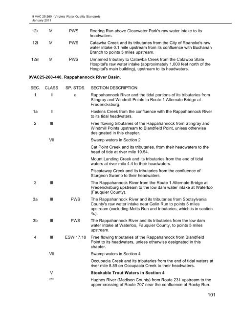
9 VAC 25-260 - <strong>Virginia</strong> <strong>Water</strong> <strong>Quality</strong> <strong>Standards</strong><br />
January 2011<br />
12k IV PWS Roaring Run above Clearwater Park's raw water intake to its<br />
headwaters.<br />
12l IV PWS Catawba Creek and its tributaries from the City of Roanoke's raw<br />
water intake 0.1 mile upstream from its confluence with Buchanan<br />
Branch to points 5 miles upstream.<br />
12m IV PWS Unnamed tributary to Catawba Creek from the Catawba State<br />
Hospital's raw water intake (approximately 1,000 feet north of the<br />
Hospital's main building), upstream to its headwaters.<br />
9VAC25-260-440. Rappahannock River Basin.<br />
SEC. CLASS SP. STDS. SECTION DESCRIPTION<br />
1 II a Rappahannock River and the tidal portions of its tributaries from<br />
Stingray and Windmill Points to Route 1 Alternate Bridge at<br />
Fredericksburg.<br />
1a II Hoskins Creek from the confluence with the Rappahannock River<br />
to its tidal headwaters.<br />
2 III Free flowing tributaries of the Rappahannock from Stingray and<br />
Windmill Points upstream to Blandfield Point, unless otherwise<br />
designated in this chapter.<br />
VII Swamp waters in Section 2<br />
Cat Point Creek and its tributaries, from their headwaters to the<br />
head of tide at river mile 10.54.<br />
Mount Landing Creek and its tributaries from the end of tidal<br />
waters at river mile 4.4 to their headwaters.<br />
Piscataway Creek and its tributaries from the confluence of<br />
Sturgeon Swamp to their headwaters.<br />
3 III The Rappahannock River from the Route 1 Alternate Bridge at<br />
Fredericksburg upstream to the low dam water intake at <strong>Water</strong>loo<br />
(Fauquier County).<br />
3a III PWS The Rappahannock River and its tributaries from Spotsylvania<br />
County's raw water intake near Golin Run to points 5 miles<br />
upstream (excluding Motts Run and tributaries, which is in section<br />
4c).<br />
3b III PWS The Rappahannock River and its tributaries from the low dam<br />
water intake at <strong>Water</strong>loo, Fauquier County, to points 5 miles<br />
upstream.<br />
4 III ESW 17,18 Free flowing tributaries of the Rappahannock from Blandfield<br />
Point to its headwaters, unless otherwise designated in this<br />
chapter.<br />
VII Swamp waters in Section 4<br />
Occupacia Creek and its tributaries from the end of tidal waters at<br />
river mile 8.89 on Occupacia Creek to their headwaters.<br />
V Stockable Trout <strong>Water</strong>s in Section 4<br />
*** Hughes River (Madison County) from Route 231 upstream to the<br />
upper crossing of Route 707 near the confluence of Rocky Run.<br />
101


