Virginia Water Quality Standards - Water - US Environmental ...
Virginia Water Quality Standards - Water - US Environmental ...
Virginia Water Quality Standards - Water - US Environmental ...

Create successful ePaper yourself
Turn your PDF publications into a flip-book with our unique Google optimized e-Paper software.
9 VAC 25-260 - <strong>Virginia</strong> <strong>Water</strong> <strong>Quality</strong> <strong>Standards</strong><br />
January 2011<br />
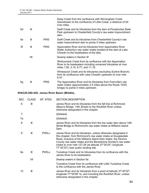
Deep Creek from the confluence with Winningham Creek<br />
downstream to the confluence of Little Creek, a distance of.54<br />
river miles.<br />
5d III Swift Creek and its tributaries from the dam at Pocahontas State<br />
Park upstream to Chesterfield County's raw water impoundment<br />
dam.<br />
5e III PWS Swift Creek and its tributaries from Chesterfield County's raw<br />
water impoundment dam to points 5 miles upstream.<br />
5f III PWS Appomattox River and its tributaries from Appomattox River<br />
<strong>Water</strong> Authority's raw water intake located at the dam at Lake<br />
Chesdin to the headwaters of the lake.<br />
VII<br />
Swamp waters in Section 5f<br />
Winticomack Creek from its confluence with the Appomattox<br />
River to its headwaters including unnamed tributaries at river<br />
miles 1.92, 3.15, 8.77, and 11.16.<br />
Winterpock Creek and its tributaries (excluding Surline Branch)<br />
from its confluence with Lake Chesdin upstream to river mile<br />
8.47.<br />
5g III PWS The Appomattox River and its tributaries from Farmville's raw<br />
water intake (approximately 2.5 miles above the Route 15/45<br />
bridge) to points 5 miles upstream.<br />
9VAC25-260-420. James River Basin (Middle).<br />
SEC. CLASS SP. STDS. SECTION DESCRIPTION<br />
6 III James River and its tributaries from the fall line at Richmond<br />
(Mayo's Bridge, 14th Street) to the Rockfish River unless<br />
otherwise designated in this chapter.<br />
7 (Deleted)<br />
7a<br />
(Deleted)<br />
8 III James River and its tributaries from the low water dam above 14th<br />
Street Bridge to Richmond's raw water intake at Williams Island<br />
Dam.<br />
9 III PWS,n James River and its tributaries, unless otherwise designated in<br />
this chapter, from Richmond's raw water intake at Douglasdale<br />
Road, inclusive of the Williams Island Dam intake, the Henrico<br />
County raw water intake and the Benedictine Society's raw water<br />
intake to river mile 127.26 (at latitude 37°35'24"; longitude<br />
77°42'33") near public landing site.<br />
9a III PWS,o Tuckahoe Creek and its tributaries from its confluence with the<br />
James River to its headwaters.<br />
VII<br />
Swamp waters in Section 9a<br />
Tuckahoe Creek from its confluence with Little Tuckahoe Creek<br />
to the confluence with the James River.<br />
10 III James River and its tributaries from a point at latitude 37°40'32";<br />
longitude 77°54'08" to, and including the Rockfish River, unless<br />
otherwise designated in this chapter.<br />
84