Virginia Water Quality Standards - Water - US Environmental ...
Virginia Water Quality Standards - Water - US Environmental ...
Virginia Water Quality Standards - Water - US Environmental ...

You also want an ePaper? Increase the reach of your titles
YUMPU automatically turns print PDFs into web optimized ePapers that Google loves.
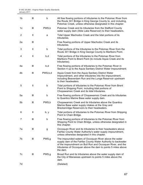
9 VAC 25-260 - <strong>Virginia</strong> <strong>Water</strong> <strong>Quality</strong> <strong>Standards</strong><br />
January 2011<br />
1b III b All free flowing portions of tributaries to the Potomac River from<br />
the Route 301 Bridge in King George County to, and including,<br />
Potomac Creek, unless otherwise designated in this chapter.<br />
1c III PWS,b Potomac Creek and its tributaries from the Stafford County<br />
water supply dam (Able Lake Reservoir) to their headwaters.<br />
2 II a Tidal Upper Machodoc Creek and the tidal portions of its<br />
tributaries.<br />
2a III Free flowing portions of Upper Machodoc Creek and its<br />
tributaries.<br />
3 II b Tidal portions of the tributaries to the Potomac River from the<br />
Route 301 Bridge in King George County to Marlboro Point.<br />
4 II b,d Tidal portions of the tributaries to the Potomac River from<br />
Marlboro Point to Brent Point (to include Aquia Creek and its<br />
tributaries).<br />
4a III b,d Free flowing portions of tributaries to the Potomac River in<br />
Section 4 up to the Aquia Sanitary District <strong>Water</strong> Impoundment.<br />
4b III PWS,b,d Aquia Creek from the Aquia Sanitary District <strong>Water</strong><br />
Impoundment, and other tributaries into the impoundment,<br />
including Beaverdam Run and the Lunga Reservoir upstream<br />
to their headwaters.<br />
5 II b Tidal portions of tributaries to the Potomac River from Brent<br />
Point to Shipping Point, including tidal portions of<br />
Chopawamsic Creek and its tidal tributaries.<br />
5a III b Free flowing portions of Chopawamsic Creek and its tributaries<br />
to Quantico Marine Base water supply dam.<br />
5b III PWS,b Chopawamsic Creek and its tributaries above the Quantico<br />
Marine Base water supply intakes at the Gray and<br />
Breckenridge Reservoirs to their headwaters.<br />
6 II b, y Tidal portions of tributaries to the Potomac River from Shipping<br />
Point to Chain Bridge.<br />
7 III b Free flowing portions of tributaries to the Potomac River from<br />
Shipping Point to Chain Bridge, unless otherwise designated in<br />
this chapter.<br />
7a III g Occoquan River and its tributaries to their headwaters above<br />
Fairfax County <strong>Water</strong> Authority's water supply impoundment,<br />
unless otherwise designated in this chapter.<br />
7b III PWS,g The impounded waters of Occoquan River above the water<br />
supply dam of the Fairfax County <strong>Water</strong> Authority to backwater<br />
of the impoundment on Bull Run and Occoquan River, and the<br />
tributaries of Occoquan above the dam to points 5 miles above<br />
the dam.<br />
7c III PWS,g Broad Run and its tributaries above the water supply dam of<br />
the City of Manassas upstream to points 5 miles above the<br />
dam.<br />
7d<br />
(Deleted)<br />
67