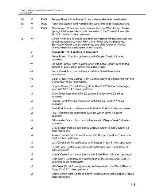
Virginia Water Quality Standards - Water - US Environmental ...
Virginia Water Quality Standards - Water - US Environmental ...
Virginia Water Quality Standards - Water - US Environmental ...

Create successful ePaper yourself
Turn your PDF publications into a flip-book with our unique Google optimized e-Paper software.
9 VAC 25-260 - <strong>Virginia</strong> <strong>Water</strong> <strong>Quality</strong> <strong>Standards</strong><br />
January 2011<br />
1d IV PWS Benges Branch from Norton's raw water intake to its headwaters.<br />
1e IV PWS Robinette Branch from Norton's raw water intake to its headwaters.<br />
1f IV PWS Fleenortown Creek and its tributaries from the Winn #1 and Barker<br />
Springs intakes (which provide raw water to the Town of Jonesville<br />
WTP) to points 5 miles upstream.<br />
2 IV Clinch River and its tributaries from the <strong>Virginia</strong>-Tennessee state line<br />
to their headwaters; North Fork Clinch River and its tributaries,<br />
Blackwater Creek and its tributaries, and Little Creek in <strong>Virginia</strong>,<br />
unless otherwise designated in this chapter.<br />
V Stockable Trout <strong>Water</strong>s in Section 2<br />
vi<br />
Amos Branch from its confluence with Copper Creek 3.3 miles<br />
upstream.<br />
*** Big Cedar Creek from its confluence with Little Cedar Creek to the<br />
mouths of Elk Garden Creek and Loop Creek.<br />
viii<br />
viii<br />
Burns Creek from its confluence with the Guest River to its<br />
headwaters.<br />
Clear Creek (Wise County) from 1/2 mile above its confluence with the<br />
Guest River to its headwaters.<br />
vi Copper Creek (Russell County) from Route 678 below Parsonage -<br />
river mile 52.5 - 4.3 miles upstream.<br />
vi<br />
vi<br />
vi<br />
vi<br />
vi<br />
Cove Creek from river mile 6.5 (above Stanleytown) 5.5 miles<br />
upstream.<br />
Cowan Creek from its confluence with Sinking Creek 2.7 miles<br />
upstream.<br />
Devil Fork from its confluence with Straight Fork 3.2 miles upstream.<br />
Fall Creek from its confluence with the Clinch River 4.6 miles<br />
upstream.<br />
Gillinswater Branch from its confluence with Obeys Creek 2.8 miles<br />
upstream.<br />
vi Gray Branch from its confluence with Mill Creek (Scott County) 1.6<br />
miles upstream.<br />
vi<br />
vi<br />
Jessee Branch from its confluence with Copper Creek at Thompson<br />
Ford 2 miles upstream.<br />
Lark Creek from its confluence with Copper Creek 3 miles upstream.<br />
viii Laurel Fork (Scott County) from its confluence with Stock Creek 4<br />
miles upstream.<br />
vi<br />
Liberty Creek from its confluence with Little River 1.6 miles upstream.<br />
vi Little Stony Creek from the intersection of the stream and Route 72<br />
upstream to its headwaters.<br />
vi<br />
Mill Creek (Scott County) from its confluence with the Clinch River at<br />
Grays Ford 1.6 miles upstream.<br />
vi Obeys Creek from 2.5 miles above its confluence with Copper Creek 6<br />
miles upstream.<br />
118