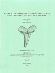
PHASE I ENVIRONMENTAL SITE ASSESSMENT OLD PANOLA ...
PHASE I ENVIRONMENTAL SITE ASSESSMENT OLD PANOLA ...
PHASE I ENVIRONMENTAL SITE ASSESSMENT OLD PANOLA ...

You also want an ePaper? Increase the reach of your titles
YUMPU automatically turns print PDFs into web optimized ePapers that Google loves.
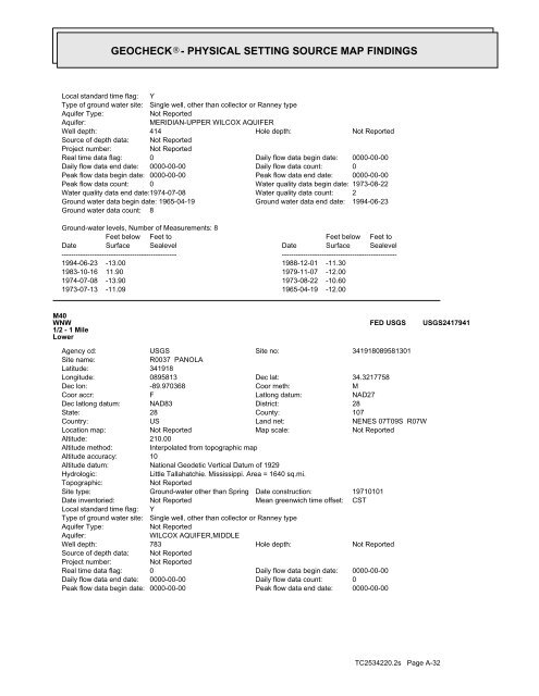
GEOCHECK ® - PHYSICAL SETTING SOURCE MAP FINDINGS<br />
Local standard time flag: Y<br />
Type of ground water site: Single well, other than collector or Ranney type<br />
Aquifer Type:<br />
Not Reported<br />
Aquifer:<br />
MERIDIAN-UPPER WILCOX AQUIFER<br />
Well depth:<br />
414<br />
Hole depth:<br />
Not Reported<br />
Source of depth data: Not Reported<br />
Project number:<br />
Not Reported<br />
Real time data flag: 0<br />
Daily flow data begin date: 0000-00-00<br />
Daily flow data end date: 0000-00-00<br />
Daily flow data count: 0<br />
Peak flow data begin date: 0000-00-00<br />
Peak flow data end date: 0000-00-00<br />
Peak flow data count: 0<br />
Water quality data begin date: 1973-08-22<br />
Water quality data end date:1974-07-08<br />
Water quality data count: 2<br />
Ground water data begin date: 1965-04-19<br />
Ground water data end date: 1994-06-23<br />
Ground water data count: 8<br />
Ground-water levels, Number of Measurements: 8<br />
Date<br />
Feet below<br />
Surface<br />
Feet to<br />
Sealevel<br />
Date<br />
Feet below<br />
Surface<br />
Feet to<br />
Sealevel<br />
-------------------------------------------------<br />
-------------------------------------------------<br />
1994-06-23 -13.00 1988-12-01 -11.30<br />
1983-10-16 11.90 1979-11-07 -12.00<br />
1974-07-08 -13.90 1973-08-22 -10.60<br />
1973-07-13 -11.09 1965-04-19 -12.00<br />
M40<br />
WNW<br />
1/2 - 1 Mile<br />
Lower<br />
FED USGS<br />
USGS2417941<br />
Agency cd:<br />
Site name:<br />
Latitude:<br />
Longitude:<br />
Dec lon:<br />
Coor accr:<br />
Dec latlong datum:<br />
State:<br />
Country:<br />
Location map:<br />
Altitude:<br />
Altitude method:<br />
Altitude accuracy:<br />
Altitude datum:<br />
Hydrologic:<br />
Topographic:<br />
Site type:<br />
Date inventoried:<br />
Local standard time flag:<br />
Type of ground water site:<br />
Aquifer Type:<br />
Aquifer:<br />
Well depth:<br />
Source of depth data:<br />
Project number:<br />
Real time data flag:<br />
Daily flow data end date:<br />
Peak flow data begin date:<br />
USGS<br />
Site no:<br />
R0037 <strong>PANOLA</strong><br />
341918<br />
0895813<br />
Dec lat:<br />
-89.970368<br />
Coor meth:<br />
F<br />
Latlong datum:<br />
NAD83<br />
District:<br />
28<br />
County:<br />
US<br />
Land net:<br />
Not Reported<br />
Map scale:<br />
210.00<br />
Interpolated from topographic map<br />
10<br />
National Geodetic Vertical Datum of 1929<br />
Little Tallahatchie. Mississippi. Area = 1640 sq.mi.<br />
Not Reported<br />
Ground-water other than Spring Date construction:<br />
Not Reported<br />
Mean greenwich time offset:<br />
Y<br />
Single well, other than collector or Ranney type<br />
Not Reported<br />
WILCOX AQUIFER,MIDDLE<br />
783<br />
Hole depth:<br />
Not Reported<br />
Not Reported<br />
0<br />
Daily flow data begin date:<br />
0000-00-00<br />
Daily flow data count:<br />
0000-00-00<br />
Peak flow data end date:<br />
341918089581301<br />
34.3217758<br />
M<br />
NAD27<br />
28<br />
107<br />
NENES 07T09S R07W<br />
Not Reported<br />
19710101<br />
CST<br />
Not Reported<br />
0000-00-00<br />
0<br />
0000-00-00<br />
TC2534220.2s Page A-32