Sterling Community Master Plan - Greenville County
Sterling Community Master Plan - Greenville County
Sterling Community Master Plan - Greenville County

You also want an ePaper? Increase the reach of your titles
YUMPU automatically turns print PDFs into web optimized ePapers that Google loves.
<strong>Sterling</strong> Neighborhood <strong>Master</strong> <strong>Plan</strong> July 2010<br />
4.0 Infrastructure: Making Neighborhood Connections<br />
4.1 Issues and Assessment<br />
4.1.1 <strong>Community</strong> Input and Team Observations<br />
• Improved streets, sidewalks, connections, accessibility by school buses, and handicapped<br />
accessibility were all key issues for residents of <strong>Sterling</strong>.<br />
• Many existing streets are narrow, have no sidewalks and open drainage ditches.<br />
• <strong>Sterling</strong> has no stormwater drainage system in the major portion of the neighborhood south<br />
of Dunbar Street.<br />
• Dunbar is a major collector street dividing the neighborhood and is a dangerous street to<br />
cross due to the speed of traffic.<br />
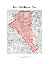
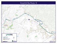
• <strong>Sterling</strong> should connect inside the neighborhood as well as to other parts of <strong>Greenville</strong>.<br />
• Trail networks are planned for the neighborhood connecting to other areas within the city.<br />
• Better street connections make for better crime prevention.<br />
4.1.2 Streets and Pedestrian Access<br />
The project team conducted an assessment of the existing streets to define current conditions<br />
within the community. A map and detailed summary table of the existing street conditions are<br />
included in Appendix C. (This summary table outlines specific road length, rights of way,<br />
jurisdiction, pavement width, curbing, sidewalks and overall condition.)<br />
In general, the roadways located north of Dunbar Street have well-established rights of way with<br />
curb/gutter, curb lawns and sidewalk. Connections are well established to the main<br />
thoroughfares of Dunbar Street, Pendleton Street, S.C. Hwy. 123 and Anderson Road. There are<br />
several platted alleyways that could be abandoned and dedicated to adjoining property owners.<br />
In contrast, the roadways south of Dunbar Street have limited rights of way without curb/gutter,<br />
curb lawns or sidewalks. Many of the rights of ways are limited to 30 feet or less. Due to the<br />
proximity of many homes to the right of way, increasing the width of the roadway is not a viable<br />
option. Some streets are so narrow that they are suitable only for one-way traffic. In addition,<br />
connectivity of the streets in the southern portion of the neighborhood is very poor, especially<br />
between Jenkins Street and Valentine Street.<br />
4.1.3 Domestic Water<br />
The <strong>Greenville</strong> Water System (GWS) owns and maintains all water lines within the community.<br />
Capacity is available to serve all residential and light commercial proposed development within<br />
the community. In the event of a large commercial project with significant fire protection<br />
requirements, GWS should be consulted early in the Schematic Design to evaluate potential<br />
upgrade requirements. Over the past ten years GWS has systematically replaced and/or upgraded<br />
portions of the system throughout the community. As redevelopment occurs, GWS will replace<br />
and/or upgrade the existing lines located within existing road right of ways. The existing lines<br />
18<br />
Continuing the community legacy and leadership