Pete Hollis Gateway Plan - City of Greenville
Pete Hollis Gateway Plan - City of Greenville
Pete Hollis Gateway Plan - City of Greenville

You also want an ePaper? Increase the reach of your titles
YUMPU automatically turns print PDFs into web optimized ePapers that Google loves.
<strong>Pete</strong> <strong>Hollis</strong> <strong>Gateway</strong> <strong>Plan</strong><br />
<strong>City</strong> <strong>of</strong> <strong>Greenville</strong>, South Carolina<br />
March 13, 2006
<strong>Pete</strong> <strong>Hollis</strong> <strong>Gateway</strong> <strong>Plan</strong><br />
Acknowledgements<br />
The <strong>City</strong> <strong>of</strong> <strong>Greenville</strong> would like to thank the following people for participating in<br />
the task force meetings and for their valuable input through the planning process:<br />
Task Force Members<br />
Robert Benedict<br />
Colleen Christian<br />
Frank Curti<br />
Mary Duckett<br />
Ed Durham<br />
Sarah Harrison<br />
Frances Hines<br />
Bob Lloyd<br />
Deb Richardson-Moore<br />
David Rosenburg<br />
Nick Skenteris<br />
Shea Smith<br />
<strong>City</strong> Council<br />
Knox H. White, Mayor<br />
Lillian Brock Flemming<br />
C. Diane Smock<br />
Michele R. Shain<br />
Debra M. S<strong>of</strong>ield<br />
Chandra E. Dillard<br />
J. David Sudduth<br />
<strong>Plan</strong>ning Commission<br />
Carolyn Cody-Fuller<br />
Sarah Day<br />
Keith Dreher<br />
Bob Ellis<br />
Mills Gallivan<br />
Barry Nocks<br />
Rick Quinn<br />
Staff<br />
Nicole Bourassa<br />
Shawn Colin<br />
Tracy Dozier<br />
Nolon Edge<br />
Leslie Fletcher<br />
Andrew Meeker<br />
Imma Nwobodu<br />
Jean Pool<br />
Jennifer Rigby<br />
Robin Smith<br />
Greg Strait<br />
Samantha Stoney<br />
Ginny Stroud<br />
Brennan Townsend<br />
Bryan Wood
<strong>Pete</strong> <strong>Hollis</strong> <strong>Gateway</strong> <strong>Plan</strong>
<strong>Pete</strong> <strong>Hollis</strong> <strong>Gateway</strong> <strong>Plan</strong><br />
Table <strong>of</strong> Contents<br />
EXECUTIVE SUMMARY ...........................................................................<br />
i<br />
VOLUME I: VISION AND CONCEPT PLAN<br />
Introduction .............................................................................................. 1<br />
<strong>Plan</strong> Purpose ....................................................................................... 3<br />
<strong>Plan</strong> Development Process ................................................................ 3<br />
Study Area Boundaries ...................................................................... 4<br />
Study Area Demographics ................................................................. 7<br />
<strong>Pete</strong> <strong>Hollis</strong> History .............................................................................. 13<br />
James Street Neighborhood .............................................................. 13<br />
West Park Neighborhood ................................................................... 14<br />
<strong>Greenville</strong> During War ........................................................................ 15<br />
Existing Conditions ................................................................................. 17<br />
Land Use and Zoning ......................................................................... 17<br />
Residential .......................................................................................... 17<br />
Historic District ............................................................................. 23<br />
Surrounding Residential Area ...................................................... 25<br />
Multifamily Housing ...................................................................... 25<br />
Commercial ......................................................................................... 27<br />
<strong>Pete</strong> <strong>Hollis</strong> Square ......................................................................... 27<br />
<strong>Pete</strong> <strong>Hollis</strong> Boulevard Commercial Corridor ............................... 27<br />
Rutherford Street Corridor ............................................................. 30<br />
Vacant Property ............................................................................. 30<br />
Transportation .................................................................................... 33<br />
Vehicular Circulation .................................................................... 33<br />
Roads ............................................................................................. 33<br />
Traffic Counts ................................................................................ 33<br />
Transit ............................................................................................ 39<br />
Driveway and Curb Cuts ............................................................... 39<br />
Non-Vehicular Circulation ............................................................ 39<br />
Bicycle Access and Circulation ................................................... 39<br />
Pedestrian Systems ...................................................................... 39<br />
Sidewalks ....................................................................................... 40<br />
Crosswalks .................................................................................... 40<br />
Safety ............................................................................................. 40<br />
Social Services ................................................................................... 40<br />
Homelessness, Very Low, Low and Moderate Income Persons<br />
and the Special Needs Population................................................. 40<br />
Law Enforcement ................................................................................ 42<br />
Table <strong>of</strong> Contents<br />
i
<strong>Pete</strong> <strong>Hollis</strong> <strong>Gateway</strong> <strong>Plan</strong><br />
Goals and Objectives .............................................................................. 43<br />
Land Use and Zoning ......................................................................... 43<br />
Economic Development ..................................................................... 43<br />
Design ................................................................................................. 43<br />
Social Services .................................................................................... 46<br />
Law Enforcement ................................................................................ 46<br />
Recommendation ..................................................................................... 47<br />
Land Use and Zoning ......................................................................... 47<br />
Economic Development ..................................................................... 47<br />
Business and Development Assistance ...................................... 47<br />
Minority Business Assistance ..................................................... 49<br />
Assistance for Historic Properties .............................................. 51<br />
Market Study Need ........................................................................ 51<br />
Design ................................................................................................. 51<br />
Rutherford Street <strong>Gateway</strong> ........................................................... 53<br />
Law Enforcement ................................................................................ 67<br />
VOLUME II<br />
Implementation and Redevelopment Obligations ................................. 71<br />
Redevelopment Responsibilities ...................................................... 71<br />
Implementation Priorities..................................................................... 71<br />
Land Use and Zoning ......................................................................... 71<br />
Historic Preservation ......................................................................... 71<br />
Economic Development ..................................................................... 72<br />
Design ................................................................................................. 72<br />
Residential Developments ................................................................. 73<br />
Social Services ................................................................................... 74<br />
Transportation .................................................................................... 75<br />
Law Enforcement ................................................................................ 75<br />
Table <strong>of</strong> Contents<br />
ii
<strong>Pete</strong> <strong>Hollis</strong> <strong>Gateway</strong> <strong>Plan</strong><br />
MAPS<br />
Map 1: <strong>Pete</strong> <strong>Hollis</strong> <strong>Gateway</strong> Context Map ................................ 2<br />
Map 2: Study Area Boundaries ................................................ 5<br />
Map 3: Current Zoning .............................................................. 18<br />
Map 4: Single Family Residential Areas .................................. 19<br />
Map 5: Existing Property Conditions ....................................... 20<br />
Map 6: Existing Building Conditions ....................................... 21<br />
Map 7: Overall Conditions ........................................................ 22<br />
Map 8: James Earle Historic District ........................................ 24<br />
Map 9: Multi-Family Residential District .................................. 26<br />
Map 10: <strong>Pete</strong> <strong>Hollis</strong> Square ......................................................... 28<br />
Map 11: <strong>Pete</strong> <strong>Hollis</strong> Boulevard Commercial Corridor ............... 29<br />
Map 12: Rutherford Street Commercial Corridor ...................... 31<br />
Map 13: Vacant Properties .......................................................... 32<br />
Map 14: <strong>Pete</strong> <strong>Hollis</strong> <strong>Gateway</strong> Concept Diagram ....................... 54<br />
Map 15: <strong>Pete</strong> <strong>Hollis</strong> <strong>Gateway</strong> Redevelopment Diagram ........... 55<br />
Map 16: Rutherford Street <strong>Gateway</strong> Design ............................... 56<br />
Map 17: Intersection Concept Diagram ..................................... 57<br />
FIGURES<br />
Fig 1: <strong>Pete</strong> <strong>Hollis</strong> Median & Streetscape ................................ 34<br />
Fig 2: Total Crime .................................................................... 42<br />
Fig 3: Streetscape Design ....................................................... 44<br />
Fig 4: Decorative Sidewalk ..................................................... 45<br />
Fig 5: Decorative Streetlight ................................................... 45<br />
Fig 6: Kash & Karry Pharmacy ............................................... 52<br />
Fig 7: Streetscape Concept .................................................... 58<br />
Fig 8: Buncombe Street Before and After ............................. 59<br />
Fig 9: <strong>Pete</strong> <strong>Hollis</strong> Streetscape Before and After ................... 60<br />
Fig 10: <strong>Pete</strong> <strong>Hollis</strong> Streetscape Before and After 2 .................. 61<br />
Fig 11: <strong>Pete</strong> <strong>Hollis</strong> Streetscape Before and After 3 ................. 62<br />
Fig 12: <strong>Pete</strong> <strong>Hollis</strong> Streetscape Median ..................................... 63<br />
Fig 13: <strong>Pete</strong> <strong>Hollis</strong> Sidewalk and Curb Lawn Before and After 64<br />
Fig 14: Building Façade Before and After ................................ 65<br />
Fig 15: <strong>Pete</strong> <strong>Hollis</strong> Corridor Wall Before and After ................. 66<br />
TABLES<br />
Table 1: Demographic Radius Report ........................................ 7<br />
Table 2: Construction Date <strong>of</strong> James Street Area .................... 14<br />
Table 3: Construction Date <strong>of</strong> David Street Area ...................... 15<br />
Table 4: Traffic Counts for <strong>Pete</strong> <strong>Hollis</strong> Boulevard ..................... 35<br />
Table 5: Traffic Counts for Buncombe Street ........................... 36<br />
Table 6: Traffic Counts for Metropolitan Drive ........................... 37<br />
Table <strong>of</strong> Contents<br />
iii
<strong>Pete</strong> <strong>Hollis</strong> <strong>Gateway</strong> <strong>Plan</strong><br />
Table <strong>of</strong> Contents<br />
iv
<strong>Pete</strong> <strong>Hollis</strong> <strong>Gateway</strong> <strong>Plan</strong><br />
Executive Summary<br />
Introduction<br />
The <strong>Pete</strong> <strong>Hollis</strong> <strong>Gateway</strong> is strategically located adjacent to the thriving<br />
downtown core. Investment in the reconstruction and realignment <strong>of</strong> Buncombe<br />
Street into the <strong>Pete</strong> <strong>Hollis</strong> Boulevard has generated interest in future<br />
development within this district as it becomes a major access route into<br />
Downtown <strong>Greenville</strong>. This highway expansion project has created both<br />
opportunities and challenges. While increased traffic capacity and connectivity<br />
along the major roadway can open up development opportunities within the<br />
district, the physical barrier created as a result <strong>of</strong> the road widening can create a<br />
disconnect between neighborhoods and deter the kind <strong>of</strong> quality development<br />
expected from the citizenry and leadership <strong>of</strong> the <strong>City</strong> <strong>of</strong> <strong>Greenville</strong>.<br />
<strong>Plan</strong>ning Process<br />
<strong>City</strong> <strong>of</strong> <strong>Greenville</strong> staff members worked together with a task force, comprised <strong>of</strong><br />
a broad cross-section <strong>of</strong> representatives from the study area, to examine the<br />
existing status, discuss issues and make recommendations to mitigate negative<br />
and build upon positive conditions within the study area. The group met several<br />
times through this process and provided invaluable insight and information that<br />
would not have been apparent otherwise. The resulting plan is a testament to<br />
the dedication and enthusiasm exhibited from the entire group.<br />
<strong>Plan</strong> Organization<br />
The <strong>Pete</strong> <strong>Hollis</strong> <strong>Gateway</strong> <strong>Plan</strong> is divided into two planning documents: Volume I:<br />
The Concept <strong>Plan</strong>, and Volume II: The Implementation <strong>Plan</strong>. The Concept <strong>Plan</strong><br />
provides background information on the <strong>Pete</strong> <strong>Hollis</strong> <strong>Gateway</strong> area and includes<br />
the vision and key recommendations to achieve the vision for the gateway. The<br />
implementation <strong>Plan</strong> includes strategies that map out redevelopment for the<br />
gateway.<br />
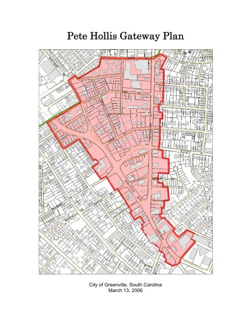
Study Area Boundaries<br />
The <strong>Pete</strong> <strong>Hollis</strong> Corridor Study Area is generally defined by the region created as<br />
a result <strong>of</strong> the <strong>Pete</strong> <strong>Hollis</strong> Highway, Rutherford Street and city limit boundaries.<br />
More specifically the area is defined as the area created along Buncombe Street<br />
from Heritage Green and extending north along the <strong>Pete</strong> <strong>Hollis</strong> Highway to the<br />
west and along Rutherford Street to the east. Shaw Street and the city limit<br />
boundary serve as the border to the north. See map on next page for graphic<br />
display <strong>of</strong> study area.<br />
Table <strong>of</strong> Contents<br />
v
<strong>Pete</strong> <strong>Hollis</strong> <strong>Gateway</strong> <strong>Plan</strong><br />
Study Area Map<br />
Issues and Opportunities<br />
Table <strong>of</strong> Contents<br />
vi
<strong>Pete</strong> <strong>Hollis</strong> <strong>Gateway</strong> <strong>Plan</strong><br />
The <strong>Gateway</strong> area has been divided into residential and commercial<br />
components, which were then divided further into sub areas that together form<br />
the <strong>Gateway</strong>’s unique character. The areas are as follows:<br />
Residential Areas<br />
• Single Family Residential Areas<br />
• James Earle Historic District<br />
• Multi-family Residential Areas<br />
Commercial Areas<br />
• <strong>Pete</strong> <strong>Hollis</strong> Square<br />
• <strong>Pete</strong> <strong>Hollis</strong> Boulevard Commercial Corridor<br />
• Rutherford Street Commercial Corridor<br />
Issues to Consider<br />
Several issues that need to be addressed within the <strong>Gateway</strong> were identified at<br />
the public meetings. These include:<br />
• Define the overall theme and identity <strong>of</strong> the Corridor<br />
• Improve the commercial environment economically and aesthetically along<br />
<strong>Pete</strong> <strong>Hollis</strong> Highway and Rutherford Road.<br />
• Increase the availability <strong>of</strong> housing stock in adjacent neighborhoods.<br />
• Improve the appearance <strong>of</strong> the Corridor and provide a sense <strong>of</strong> “entrance”<br />
into the <strong>City</strong> by developing design standards that s<strong>of</strong>ten or minimize the<br />
impact <strong>of</strong> the “freeway”.<br />
• Identify and target key redevelopment opportunities within the corridor.<br />
• Encourage new commercial, residential, and mixed-use development by<br />
accumulating key parcels, developing a marketing plan, and establishing a<br />
targeted incentive program.<br />
• Look at land bank possibilities to acquire land and prep for public/private<br />
partnerships.<br />
• Identify incompatible uses within the corridor and develop a mechanism to<br />
reduce negative impacts.<br />
• Look at ways to enhance the general safety <strong>of</strong> the area including<br />
pedestrian safety.<br />
Table <strong>of</strong> Contents<br />
vii
<strong>Pete</strong> <strong>Hollis</strong> <strong>Gateway</strong> <strong>Plan</strong><br />
Corridor Assets<br />
The <strong>Gateway</strong>’s is in close proximity to downtown and to many activity centers are<br />
important to the success and long term viability <strong>of</strong> the district as are the several<br />
strong neighborhoods adjacent to the area. It is literally a few minutes from a<br />
majority <strong>of</strong> <strong>City</strong> and area attractions, including the BiLo Center, Downtown, the<br />
West End and Falls Park, the new <strong>Greenville</strong> Drive baseball stadium, the<br />
proposed Kroc Center and much more..<br />
The growth and expansion <strong>of</strong> the Downtown core and West End also contribute<br />
to the appeal <strong>of</strong> the <strong>Pete</strong> <strong>Hollis</strong> <strong>Gateway</strong>. These areas have experienced a<br />
rebirth and have been used by other cities as models for redevelopment. The<br />
Central Business District and West End have been hot beds for <strong>of</strong>fice,<br />
residential, restaurant, and retail development activity. The area has become the<br />
center for entertainment from a cultural and recreational perspective and has<br />
become a desirable area to live work and play. However, as these areas build<br />
out, and housing affordability issues continue to surface, adjacent areas such as<br />
the <strong>Pete</strong> <strong>Hollis</strong> <strong>Gateway</strong> are positioned favorably to become more attractive as<br />
areas to provide mixed use mixed income opportunities that have several<br />
housing options.<br />
Corridor Vision<br />
Over the next five to ten years, the <strong>Pete</strong> <strong>Hollis</strong> <strong>Gateway</strong> and the surrounding<br />
area will become one <strong>of</strong> <strong>Greenville</strong>’s most attractive, cohesive and economically<br />
viable urban corridors.<br />
Key Recommendations<br />
• Create a zoning classification for the district that prohibits certain uses that<br />
do not promote the goals <strong>of</strong> this plan and allows uses that encourage<br />
redevelopment <strong>of</strong> the area.<br />
• In concert with area residents, property owners, and the <strong>City</strong>’s Design &<br />
Preservation Commission, evaluate residential neighborhoods in and<br />
around the study area to determine the potential for new or expanded<br />
preservation overlay districts.<br />
• Develop conservation districts for residential neighborhoods that may not<br />
be appropriate for historic designation but are worthy <strong>of</strong> preservation<br />
and/or rehabilitation and would benefit greatly from implementing a system<br />
for such.<br />
• Provide incentives for mixed-use developments.<br />
• Continue to form collaborative partnerships among business and property<br />
owners, area residents, and neighborhood organizations to promote and<br />
plan for the <strong>Gateway</strong>. Maintian links with established groups on James<br />
Street, Hampton-Pinckney, Voila Street, the Northend Association, and<br />
others to ensure coordination and joint planning will be maintained.<br />
Table <strong>of</strong> Contents<br />
viii
<strong>Pete</strong> <strong>Hollis</strong> <strong>Gateway</strong> <strong>Plan</strong><br />
• Utilize a land assembly and infrastructure improvement program to<br />
leverage qualified private investment. This program is vital to the<br />
implementation <strong>of</strong> redevelopment opportunities within the <strong>Pete</strong> <strong>Hollis</strong><br />
<strong>Gateway</strong>.<br />
• Identify projects within the <strong>Pete</strong> <strong>Hollis</strong> <strong>Gateway</strong> that could be funded by<br />
the Viola Street Tax Increment Finance District.<br />
• Develop and implement a marketing strategy to promote the <strong>Pete</strong> <strong>Hollis</strong><br />
<strong>Gateway</strong>.<br />
• The <strong>City</strong> will continue to develop more detailed implementation strategies<br />
as planning for the <strong>Gateway</strong> continues.Maintain consistent and compatible<br />
building types throughout the corridor.<br />
• Locate buildings close to the street with front doors and windows that<br />
orient toward the street.<br />
• Where possible, attach buildings to each other to help define the<br />
pedestrian space along streets and create an attractive row <strong>of</strong> store fronts.<br />
• Encourage residential development above nonresidential uses and a<br />
mixture <strong>of</strong> uses in buildings.<br />
• Install clear glass in the first row <strong>of</strong> windows and buildings and enrich with<br />
displays, information, etc.<br />
• Minimize the size and location <strong>of</strong> parking areas and strategically position<br />
them to minimize their visual impact.<br />
• Provide parking behind the buildings and screen from public view.<br />
Table <strong>of</strong> Contents<br />
ix
VOLUME I: CONCEPT PLAN
<strong>Pete</strong> <strong>Hollis</strong> <strong>Gateway</strong> <strong>Plan</strong><br />
Introduction<br />
The <strong>Pete</strong> <strong>Hollis</strong> <strong>Gateway</strong> is strategically located adjacent to the thriving<br />
downtown core. Investment in the reconstruction and realignment <strong>of</strong> Buncombe<br />
Street into the <strong>Pete</strong> <strong>Hollis</strong> Boulevard has generated interest in future<br />
development within this district as it becomes a major access route into<br />
Downtown <strong>Greenville</strong>. This highway expansion project has created both<br />
opportunities and challenges. While increased traffic capacity and connectivity<br />
along the major roadway can open up development opportunities within the<br />
district, the physical barrier created as a result <strong>of</strong> the road widening can create a<br />
disconnect between neighborhoods and deter the kind <strong>of</strong> quality development<br />
expected from the citizenry and leadership <strong>of</strong> the <strong>City</strong> <strong>of</strong> <strong>Greenville</strong>.<br />
The reconstruction <strong>of</strong> Buncombe Street and its potential impact on the<br />
surrounding area have once again raised a number <strong>of</strong> questions from <strong>City</strong><br />
leadership, <strong>City</strong> staff, area residents and business owners. The answer to these<br />
questions will affect the future development <strong>of</strong> the area. It is important to look at<br />
the existing conditions within the area and develop specific strategies to integrate<br />
it as an asset within the overall <strong>City</strong> context. Now is the time to address these<br />
opportunities and challenges<br />
There are numerous factors that contribute to the changes taking place within the<br />
<strong>Pete</strong> <strong>Hollis</strong> <strong>Gateway</strong>. Proximity to downtown, several strong neighborhoods<br />
within and adjacent to the area and access to many activity centers are important<br />
to the success and long term viability <strong>of</strong> the district. It is literally a few minutes<br />
from a majority <strong>of</strong> <strong>City</strong> and area attractions, including the BiLo Center,<br />
Downtown, the West End and Falls Park, the new <strong>Greenville</strong> Drive baseball<br />
stadium, the proposed Kroc Center and much more, see Map 1 on page 2.<br />
The growth and expansion <strong>of</strong> the Downtown core and West End also contribute<br />
to the appeal <strong>of</strong> the <strong>Pete</strong> <strong>Hollis</strong> <strong>Gateway</strong>. These areas have experienced a<br />
rebirth and have been used by other cities as models for redevelopment. The<br />
Central Business District and West End have been hot beds for <strong>of</strong>fice,<br />
residential, restaurant, and retail development activity. The area has become the<br />
center for entertainment from a cultural and recreational perspective and has<br />
become a desirable area to live work and play. However, as these areas build<br />
out, and housing affordability issues continue to surface, adjacent areas such as<br />
the <strong>Pete</strong> <strong>Hollis</strong> <strong>Gateway</strong> are positioned favorably to become more attractive as<br />
areas to provide mixed use mixed income opportunities that have several<br />
housing options.<br />
Volume I: Vision and Concept <strong>Plan</strong> 1
Map 1: <strong>Pete</strong> <strong>Hollis</strong> <strong>Gateway</strong> Context Map<br />
<strong>Pete</strong> <strong>Hollis</strong> <strong>Gateway</strong> <strong>Plan</strong><br />
This map shows the <strong>Pete</strong> <strong>Hollis</strong> <strong>Gateway</strong> Study Area (red), and its relationship to<br />
Downtown <strong>Greenville</strong> and the West End District (tan) and <strong>City</strong> Parks(green).<br />
Volume I: Vision and Concept <strong>Plan</strong> 2
<strong>Pete</strong> <strong>Hollis</strong> <strong>Gateway</strong> <strong>Plan</strong><br />
Finally, the desire for convenient, accessible locations in a time when traffic<br />
congestion is mounting makes the <strong>Pete</strong> <strong>Hollis</strong> <strong>Gateway</strong> a good candidate for<br />
revitalization. It has immediate access to Interstates 85 and 385, as well as other<br />
key business corridors including Main Street, Laurens, Haywood, and Woodruff<br />
Roads, and Pleasantburg Drive. In addition, the area is linked with public transit<br />
routes from the <strong>Greenville</strong> Transit Authority. This strategic location, partnered<br />
with the unique character <strong>of</strong> the <strong>Pete</strong> <strong>Hollis</strong> <strong>Gateway</strong>, with its views <strong>of</strong> the <strong>City</strong><br />
skyline, strong neighborhood edges and historic district has many qualities<br />
inherent in revitalization projects.<br />
The <strong>Pete</strong> <strong>Hollis</strong> <strong>Gateway</strong> is well positioned for revitalization. But the challenge is<br />
to ensure that as the district redevelops, it does so within the context <strong>of</strong> a larger,<br />
comprehensive vision: a vision that builds on and ties together the district’s<br />
distinct character, historic flavor and functional relationship to the Downtown,<br />
surrounding neighborhoods and business corridors. Without a vision to guide<br />
revitalization efforts, the <strong>Gateway</strong>’s full potential may never be realized.<br />
<strong>Plan</strong> Purpose<br />
The purpose <strong>of</strong> the <strong>Pete</strong> <strong>Hollis</strong> <strong>Gateway</strong> Master <strong>Plan</strong> is to provide a context for<br />
redevelopment to occur within the study area. It includes a comprehensive urban<br />
design and land use vision articulated through a series <strong>of</strong> development concepts<br />
for the <strong>Gateway</strong>. The plan also provides general strategies to begin<br />
implementation.<br />
When adopted by <strong>City</strong> Council, this plan will become a policy guide to help<br />
elected and appointed <strong>of</strong>ficials, <strong>City</strong> staff and the private sector make decisions<br />
about the future <strong>of</strong> the <strong>Pete</strong> <strong>Hollis</strong> <strong>Gateway</strong>. It can also be used as a tool to<br />
promote the area and its potential. In short, this plan lays the foundation for<br />
continued and increased public and private sector involvement as momentum<br />
and synergy build in the area.<br />
<strong>Plan</strong> Development Process<br />
The development <strong>of</strong> this plan reflects the commitment <strong>of</strong> both leadership and<br />
citizens to maximize the potential <strong>of</strong> the area, incorporate the highway expansion<br />
as an asset and catalyst for development and to integrate quality <strong>of</strong> form and<br />
efficiency <strong>of</strong> function <strong>of</strong> the <strong>Pete</strong> <strong>Hollis</strong> Corridor. <strong>City</strong> <strong>of</strong> <strong>Greenville</strong> staff members<br />
worked together with a task force, comprised <strong>of</strong> a broad cross-section <strong>of</strong><br />
representatives from the study area, to examine the existing status, discuss<br />
issues and make recommendations to mitigate negative and build upon positive<br />
conditions within the study area. The group met several times through this<br />
process and provided invaluable insight and information that would not have<br />
been apparent otherwise. The resulting plan is a testament to the dedication and<br />
enthusiasm exhibited from the entire group.<br />
Volume I: Vision and Concept <strong>Plan</strong> 3
<strong>Pete</strong> <strong>Hollis</strong> <strong>Gateway</strong> <strong>Plan</strong><br />
The final step <strong>of</strong> the planning process is to implement the strategies and<br />
recommendations outlined in this plan and to develop the <strong>Pete</strong> <strong>Hollis</strong> Corridor as<br />
an asset to the <strong>City</strong> <strong>of</strong> <strong>Greenville</strong> and its citizens. A detailed assessment <strong>of</strong><br />
existing conditions and an implementation section that includes strategic<br />
initiatives and programs that will increase the viability <strong>of</strong> the area and ensure<br />
quality development and increase quality <strong>of</strong> life are the specific products <strong>of</strong> this<br />
plan. The specific issues addressed in the plan are outlined below:<br />
• Define the overall theme and identity <strong>of</strong> the Corridor<br />
• Improve the commercial environment economically and aesthetically along<br />
<strong>Pete</strong> <strong>Hollis</strong> Highway and Rutherford Road.<br />
• Increase the availability <strong>of</strong> housing stock in adjacent neighborhoods.<br />
• Improve the appearance <strong>of</strong> the Corridor and provide a sense <strong>of</strong> “entrance”<br />
into the <strong>City</strong> by developing design standards that s<strong>of</strong>ten or minimize the<br />
impact <strong>of</strong> the “freeway”.<br />
• Identify and target key redevelopment opportunities within the corridor.<br />
• Encourage new commercial, residential, and mixed-use development by<br />
accumulating key parcels, developing a marketing plan, and establishing a<br />
targeted incentive program.<br />
• Look at land bank possibilities to acquire land and prep for public/private<br />
partnerships.<br />
• Identify incompatible uses within the corridor and develop a mechanism to<br />
reduce negative impacts.<br />
• Look at ways to enhance the general safety <strong>of</strong> the area including<br />
pedestrian safety.<br />
Study Area Boundaries<br />
The <strong>Pete</strong> <strong>Hollis</strong> Corridor Study Area is generally defined by the region created as<br />
a result <strong>of</strong> the <strong>Pete</strong> <strong>Hollis</strong> Highway, Rutherford Street and city limit boundaries.<br />
More specifically the area is defined as the area created along Buncombe Street<br />
from Heritage Green and extending north along the <strong>Pete</strong> <strong>Hollis</strong> Highway to the<br />
west and along Rutherford Street to the east. Shaw Street and the city limit<br />
boundary serve as the border to the north. See Map 2 for graphic display <strong>of</strong><br />
study area on Page 5.<br />
Volume I: Vision and Concept <strong>Plan</strong> 4
<strong>Pete</strong> <strong>Hollis</strong> <strong>Gateway</strong> <strong>Plan</strong><br />
Map 2: Study Area Map<br />
Volume I: Vision and Concept <strong>Plan</strong> 5
<strong>Pete</strong> <strong>Hollis</strong> <strong>Gateway</strong> <strong>Plan</strong><br />
Volume I: Vision and Concept <strong>Plan</strong> 6
<strong>Pete</strong> <strong>Hollis</strong> <strong>Gateway</strong> <strong>Plan</strong><br />
Study Area Demographics<br />
The following table provides a summary <strong>of</strong> the demographic and socioeconomic conditions based upon a 1, 2, and 3 mile<br />
radius report generated using the midpoint <strong>of</strong> West Stone Avenue, between <strong>Pete</strong> <strong>Hollis</strong> Boulevard and Rutherford Street,<br />
as the center point <strong>of</strong> the radius.<br />
Table 1: Radius Report<br />
Category Data 1 Mile 2 Miles 3 Miles<br />
Square Miles 6.5 21.8 50.7<br />
Population,<br />
Households, &<br />
Families<br />
2003<br />
Population<br />
By Race and<br />
Hispanic Origin<br />
2003<br />
Household Size<br />
2000 Population 16,548 53,448 105,615<br />
2003 Population 16,213 52,447 104,924<br />
2008 Population 15,724 51,037 104,114<br />
2000 Number <strong>of</strong> Households 6,906 22,509 44,583<br />
2003 Number <strong>of</strong> Households 6,859 22,331 44,721<br />
2008 Number <strong>of</strong> Households 6,795 22,109 45,038<br />
2000 Number <strong>of</strong> Families 3,408 12,807 25,537<br />
2003 Number <strong>of</strong> Families 3,327 12,507 25,220<br />
2008 Number <strong>of</strong> Families 3,207 12,068 24,775<br />
White 9,889 29,910 71,820<br />
Black 5,605 20,123 26,879<br />
American Indian / Eskimo / Aleut 45 130 257<br />
Asian / Pacific Islander 118 436 1,425<br />
Other Race 334 1,143 3,021<br />
Two or More Races 213 667 1,443<br />
Hispanic Origin 975 3,333 8,095<br />
Households with 1 Person 2,981 8,323 16,397<br />
Households with 2 Persons 1,881 6,765 14,161<br />
Households with 3 - 5 Persons 1,805 6,610 13,042<br />
Households with 6+ Persons 192 633 1,121<br />
Population Never Married 4,073 12,930 26,418<br />
Population Now Married (Excluding Separated) 4,301 15,790 34,753<br />
Population Separated 1,994 4,318 7,395<br />
Volume I: Vision and Concept <strong>Plan</strong> 7
<strong>Pete</strong> <strong>Hollis</strong> <strong>Gateway</strong> <strong>Plan</strong><br />
Table 1: Radius Report: continued<br />
Category Data 1 Mile 2 Miles 3 Miles<br />
Population (Age 15+)<br />
Population Age Groups<br />
Population Widowed 1,359 4,295 7,824<br />
Population Divorced 1,767 4,999 9,569<br />
2003 Population, Age 0 to 4 936 3,426 6,579<br />
2003 Population, Age 5 to 9 858 3,223 6,118<br />
2003 Population, Age 10 to 14 925 3,466 6,268<br />
2003 Population, Age 15 to 17 521 1,907 3,419<br />
2003 Population, Age 18 to 24 1,413 4,739 12,038<br />
2003 Population, Age 25 to 34 2,702 7,965 16,617<br />
2003 Population, Age 35 to 44 2,691 7,747 15,090<br />
2003 Population, Age 45 to 54 2,274 7,054 13,437<br />
2003 Population, Age 55 to 59 838 2,734 5,326<br />
2003 Population, Age 60 to 64 649 2,109 4,052<br />
2003 Population, Age 65 to 74 984 3,481 6,984<br />
2003 Population, Age 75+ 1,422 4,596 8,996<br />
2008 Population, Age 0 to 4 910 3,343 6,461<br />
2008 Population, Age 5 to 9 902 3,281 6,430<br />
2008 Population, Age 10 to 14 798 3,057 5,966<br />
2008 Population, Age 15 to 17 545 1,919 3,489<br />
2008 Population, Age 18 to 24 1,314 4,395 10,890<br />
2008 Population, Age 25 to 34 2,377 7,480 15,658<br />
2008 Population, Age 35 to 44 2,606 7,352 15,189<br />
2008 Population, Age 45 to 54 2,267 7,145 14,169<br />
2008 Population, Age 55 to 59 941 2,985 5,778<br />
2008 Population, Age 60 to 64 726 2,427 4,865<br />
2008 Population, Age 65 to 74 1,002 3,377 6,714<br />
2008 Population, Age 75+ 1,336 4,276 8,505<br />
Volume I: Vision and Concept <strong>Plan</strong> 8
<strong>Pete</strong> <strong>Hollis</strong> <strong>Gateway</strong> <strong>Plan</strong><br />
Table 1: Radius Report: continued<br />
Category Data 1 Mile 2 Miles 3 Miles<br />
2003<br />
Highest Educational<br />
Attainment Of Population<br />
(Age 25+)<br />
2003<br />
Employment Status<br />
Of Population (Age 16+)<br />
2003<br />
Selected Occupations<br />
Of Population<br />
(Persons LIVING In This Area)<br />
(Age 16+)<br />
Population Less than 9th Grade 2,011 5,020 7,600<br />
Population 9th -12th Grade No Diploma 2,819 8,190 12,623<br />
Population High School Graduate 2,839 9,585 18,673<br />
Population Some College No Degree 1,570 5,424 12,233<br />
Population with Associate Degree 427 1,655 3,984<br />
Population with Bachelor's Degree 1,273 3,897 10,154<br />
Population with Master's Degree 408 1,295 3,481<br />
Population with Pr<strong>of</strong>essional Degree 145 412 1,209<br />
Population with Doctorate Degree 68 208 545<br />
In Military 16 47 76<br />
Labor Force, Employed 6,723 22,332 49,835<br />
Labor Force, Unemployed 746 1,840 3,451<br />
Not in Labor Force 5,855 17,461 31,408<br />
Agriculture / Forestry / Fishing and Hunting / Mining 34 135 226<br />
Construction 729 1,998 4,077<br />
Manufacturing 1,266 4,249 9,061<br />
Wholesale Trade 260 923 1,927<br />
Retail Trade 824 2,738 6,025<br />
Transportation / Warehousing / Utilities 167 814 1,744<br />
Finance / Insurance / Real Estate 255 999 2,730<br />
Educational Services 414 1,618 4,658<br />
Heath Care / Social Assistance 565 2,056 4,590<br />
Arts / Entertainment / Recreation 122 271 698<br />
Volume I: Vision and Concept <strong>Plan</strong> 9
<strong>Pete</strong> <strong>Hollis</strong> <strong>Gateway</strong> <strong>Plan</strong><br />
Table 1: Radius Report: continued<br />
Category Data 1 Mile 2 Miles 3 Miles<br />
2003<br />
Selected<br />
Occupations<br />
Of Persons<br />
WORKING in<br />
This Area<br />
(Age 16+)<br />
Household<br />
Income<br />
Total Employment (All Industries) 1 30,268 50,234 89,748<br />
Agriculture / Forestry / Fishing and Hunting / Mining 112 244 440<br />
Construction 1,496 2,701 3,827<br />
Manufacturing 3,596 5,863 8,809<br />
Wholesale Trade 943 1,748 2,944<br />
Retail Trade 3,842 8,455 17,060<br />
Transportation / Warehousing / Utilities 3,520 3,984 4,890<br />
Finance / Insurance / Real Estate 3,852 5,132 8,563<br />
Educational Services 951 2,201 4,644<br />
Heath Care / Social Assistance 1,258 3,318 13,150<br />
Arts / Entertainment / Recreation 288 528 977<br />
2003 Average Household Income 36,626 39,236 46,797<br />
2003 Median Household Income Less Than $15,000 2,086 6,545 9,726<br />
2003 Median Household Income $15,000 - 24,999 1,209 3,715 6,779<br />
2003 Median Household Income $25,000 - 34,999 1,050 3,430 6,812<br />
2003 Median Household Income $35,000 - 49,999 997 3,352 7,648<br />
2003 Median Household Income $50,000 - 74,999 784 2,697 6,730<br />
2003 Median Household Income $75,000 - 99,999 336 1,091 3,028<br />
2003 Median Household Income $100,000 - 149,999 271 925 2,529<br />
2003 Median Household Income $150,000 - 249,999 102 448 1,052<br />
2003 Median Household Income $250,000 & Above 24 128 417<br />
2008 Average Household Income 41,587 44,616 53,307<br />
2008 Median Household Income Less Than $15,000 1,838 5,766 8,540<br />
2008 Median Household Income $15,000 - 24,999 1,091 3,360 6,012<br />
2008 Median Household Income $25,000 - 34,999 973 3,153 6,105<br />
2008 Median Household Income $35,000 - 49,999 1,120 3,551 7,828<br />
2008 Median Household Income $50,000 - 74,999 839 2,985 7,471<br />
2008 Median Household Income $75,000 - 99,999 409 1,374 3,740<br />
2008 Median Household Income $100,000 - 149,999 356 1,185 3,392<br />
2008 Median Household Income $150,000 - 249,999 128 525 1,344<br />
2008 Median Household Income $250,000 & Above 41 210 606<br />
Volume I: Vision and Concept <strong>Plan</strong> 10
<strong>Pete</strong> <strong>Hollis</strong> <strong>Gateway</strong> <strong>Plan</strong><br />
Table 1: Radius Report: continued<br />
Category Data 1 Mile 2 Miles 3 Miles<br />
Housing Units<br />
2003<br />
Housing Value<br />
2003<br />
Business<br />
Establishments<br />
In this Area by<br />
Industry Sector<br />
2000 Housing Units 8,013 25,720 49,636<br />
2003 Housing Units 7,956 25,511 49,775<br />
2008 Housing Units 7,878 25,248 50,113<br />
2000 Owner Occupied Housing Units 2,998 10,890 24,018<br />
2003 Owner Occupied Housing Units 2,991 10,848 24,166<br />
2008 Owner Occupied Housing Units 2,984 10,801 24,457<br />
2000 Renter Occupied Housing Units 3,908 11,619 20,565<br />
2003 Renter Occupied Housing Units 3,868 11,483 20,555<br />
2008 Renter Occupied Housing Units 3,811 11,308 20,581<br />
2003 Owner Occupied Housing, Value Less than $40,000 503 1,441 2,594<br />
2003 Owner Occupied Housing, Value $40,000 - 59,999 684 1,868 2,886<br />
2003 Owner Occupied Housing, Value $60,000 - 79,999 426 2,070 3,855<br />
2003 Owner Occupied Housing, Value $80,000 - 99,999 254 1,605 3,828<br />
2003 Owner Occupied Housing, Value $100,000 - 149,999 551 1,888 5,250<br />
2003 Owner Occupied Housing, Value $150,000 - 199,999 294 883 2,691<br />
2003 Owner Occupied Housing, Value $200,000 - 299,999 173 570 1,744<br />
2003 Owner Occupied Housing, Value $300,000 & greater 106 523 1,318<br />
Total Business Establishments (Private Sector) 2,377 4,384 7,060<br />
Agriculture / Forestry / Fishing and Hunting / Mining Industries 23 45 82<br />
Construction Industries 148 229 374<br />
Manufacturing Industries (Nondurable and Durable Goods) 134 235 366<br />
Transportation / Communications / Public Utilities 70 123 208<br />
Wholesale Trade Industries 97 166 292<br />
Retail Trade Industries 304 758 1,414<br />
Finance / Insurance / Real Estate 347 562 870<br />
Business & Repair / Personal Services 350 737 1,218<br />
Arts / Entertainment / Recreation 37 73 122<br />
Heath Care / Social Assistance 112 268 552<br />
Educational Services 30 76 126<br />
Volume I: Vision and Concept <strong>Plan</strong> 11
<strong>Pete</strong> <strong>Hollis</strong> <strong>Gateway</strong> <strong>Plan</strong><br />
2003<br />
Selected Retail<br />
Establishments<br />
In This Area<br />
(By SIC Code)<br />
Table 1: Radius Report: continued<br />
Category Data 1 Mile 2 Miles 3 Miles<br />
2003<br />
Average Annual<br />
Household Expenditures 2<br />
(For Selected<br />
Goods and Services)<br />
SIC 52 - Building Materials / Garden Supplies 12 31 64<br />
SIC 53 - General Merchandise Stores 4 21 36<br />
SIC 54 - Food Stores 32 85 144<br />
SIC 55 - Auto Dealers / Gasoline Services Stations 39 93 180<br />
SIC 56 - Apparel and Accessory Stores 20 52 108<br />
SIC 57 - Home Furniture / Furnishings / Equipment Stores 32 86 161<br />
SIC 58 - Eating and Drinking Places 83 192 363<br />
SIC 59 - Miscellaneous Retail Establishments 82 198 358<br />
At Restaurants 2,307 2,360 2,748<br />
At Grocery Stores 4,029 4,165 4,386<br />
On Education 677 696 1,044<br />
On Apparel 2,394 2,601 3,022<br />
On Furniture and Appliances 556 618 734<br />
On Home Audio / Video Sales, Rental and Service 961 1,012 1,169<br />
On Sports and Recreation 652 714 860<br />
Charitable and Religious Contributions 365 398 473<br />
On Pets, Pet Supplies, and Veterinary Services 176 190 217<br />
On Automobiles 2,214 2,555 3,034<br />
On Healthcare 2,495 2,606 2,778<br />
On Travel 614 679 856<br />
This report is a product <strong>of</strong> the infoMentum program, a decision support system for Upstate South Carolina .<br />
Source <strong>of</strong> data: US Census Bureau and Claritas, Incorporated<br />
1 Please note that the selected occupations shown are not all inclusive, and their summation will therefore not equal this total<br />
Calculation method was revised March 2005<br />
Volume I: Vision and Concept <strong>Plan</strong> 12
<strong>Pete</strong> <strong>Hollis</strong> <strong>Gateway</strong> <strong>Plan</strong><br />
<strong>Pete</strong> <strong>Hollis</strong> History<br />
James Street Neighborhood<br />
The following information has been complied directly from The Historic<br />
Resources <strong>of</strong> <strong>Greenville</strong>, South Carolina; prepared by Building Conservation<br />
Technology, Inc., Nashville, Tennessee, 1981.<br />
The James and Earle Street neighborhoods evolved around the large estate <strong>of</strong><br />
the Earle family. Col. Elias Earle moved to <strong>Greenville</strong> County in the late 18 th<br />
century and acquired lands to the north <strong>of</strong> the city. In 1813, Earle sold much <strong>of</strong><br />
his property to Henry Middleton <strong>of</strong> Charleston who built the home at 310 E. Earle<br />
known as “Whitehall” as his summer residence. Middleton later sold this house<br />
back to the Earle family and their descendants have continued to occupy the<br />
house. The area along James Street was also Earle property after 1834, when<br />
33 acres were bought by Elias Drayton Earle. Earle acquired not only the land<br />
but a house at 107 James Street. The exact construction date <strong>of</strong> this house is<br />
not known, but is believed to have been on the site by 1826 and possibly as early<br />
as 1810. Both the Elias Earle house and “Whitehall” are important landmarks in<br />
the city and have been listed on the National Register <strong>of</strong> Historic Places.<br />
The land along James Street was the first area to be subdivided by the Earle<br />
family. By the late 19 th century, lots had been sold and the Victorian style houses<br />
at 100 and 102 James were constructed. The area near the intersection <strong>of</strong><br />
James and Buncombe was not subdivided until later and most <strong>of</strong> these homes<br />
are <strong>of</strong> the ca. 1920 Colonial Revival style. James Street has recently been<br />
designated as a local Historic Preservation Area and has been nominated to the<br />
National Register <strong>of</strong> Historic Places.<br />
Earle Street was also laid out and subdivided in the early 20 th century. The land<br />
at the northwest corner <strong>of</strong> West Earle and Rutherford Street was the front lawn <strong>of</strong><br />
Whitehall. Florida L. Stone gave the lots facing these streets to her seven<br />
remaining children. By 1915 this land was already experiencing residential<br />
development. These early homes showed varied styles reflecting the transition<br />
from Victorian architecture into more contemporary styles. Building designs from<br />
this period include the Dutch Colonial home at 108 W. Earle, shingle-style home<br />
at 107 W. Earle, and the Classic Revival McSwain home at 715 N. Main. Other<br />
vernacular style homes were also built on Earle during this decade.<br />
Volume I: Vision and Concept <strong>Plan</strong> 13
<strong>Pete</strong> <strong>Hollis</strong> <strong>Gateway</strong> <strong>Plan</strong><br />
Table 2: Construction Date <strong>of</strong> James Street Area<br />
Address Year Address Year<br />
9 James Street ca. 1900 113 James Street 1912<br />
10 James Street ca. 1915 117 James Street ca. 1920<br />
11 James Street ca. 1925 118 James Street 1910<br />
100 James Street ca. 1900 119 James Street ca. 1925<br />
101 James Street ca. 1920 122 James Street ca. 1920<br />
102 James Street ca. 1920 123 James Street ca. 1920<br />
106 James Street 1920 126 James Street ca. 1920<br />
107 James Street ca. 1826 310 W. Earle Street 1813<br />
West Park Neighborhood<br />
The West Park neighborhood is an early 20 th century residential area and<br />
features many variations <strong>of</strong> the Bungalow style house. Dr. S.S. Marshall owned<br />
much <strong>of</strong> the West Park neighborhood in the late 19 th century. Dr. Marshall<br />
maintained a large vineyard along Wilton Street for many years. Later the land<br />
began to be subdivided into residential lots in 1909. A few homes were built in<br />
the area before 1910. These include the altered Queen Ann style house at 401<br />
Townes Street and the Classic Revival style houses at 500 and 426 Townes<br />
Street. Other early homes are at 15, 16, and 21 Atwood and 107 W. Park. The<br />
majority <strong>of</strong> homes in the West Park neighborhood were built after 1915 in the<br />
Bungalow style. The addition <strong>of</strong> wooden shingles to the exterior <strong>of</strong> these homes<br />
is a common feature.<br />
Several notable churches are also located near the West Park area. The Triune<br />
Methodist Church and Trinity Lutheran Church were built in the Gothic Revival<br />
style with arched windows and doorways. The Neo-Classical style Third<br />
Presbyterian Church and Faith Tabernacle Apostolic Church also display<br />
interesting architectural designs.<br />
• Third Presbyterian Church: Neo-classical church built in 1916<br />
• Corner <strong>of</strong> Rutherford and Buncombe: Three story triangular brick<br />
commercial building built ca. 1915<br />
• 200 Rutherford: Victorian house ca. 1900<br />
• Coca Cola <strong>Plan</strong>t: Building ca. 1928. In 2002 became the new<br />
<strong>Greenville</strong> County Public Library and Museum <strong>of</strong> Upcountry History.<br />
• 15, 17, and 21 Atwood: built ca. 1915<br />
Volume I: Vision and Concept <strong>Plan</strong> 14
<strong>Pete</strong> <strong>Hollis</strong> <strong>Gateway</strong> <strong>Plan</strong><br />
Table 3: Construction Date <strong>of</strong> David Street Area<br />
Address Year Address Year<br />
7 David Street ca. 1930 16 David Street n/a<br />
8 David Street ca. 1925 17 David Street ca. 1920<br />
9 David Street ca. 1920 18 David Street ca. 1920<br />
10 David Street ca. 1925 19 David Street ca. 1925<br />
11 David Street ca. 1925 423 Rutherford Street ca. 1880<br />
12 David Street ca. 1920 427 Rutherford Street ca. 1920<br />
<strong>Greenville</strong> During War<br />
The following excerpts are from Images <strong>of</strong> America: <strong>Greenville</strong>, by Piper <strong>Pete</strong>rs<br />
Aheron.<br />
Just <strong>of</strong>f Rutherford Road on Earl Street stands the summer home <strong>of</strong> Governor<br />
Henry Middleton, son <strong>of</strong> Arthur Middleton, a signer <strong>of</strong> the Declaration <strong>of</strong><br />
Independence. The Middleton’s from 1813 to 1820 occupied Whitehall, a<br />
Charleston-styled house. During the Spanish-American War, when U.S. troops<br />
were stationed in <strong>Greenville</strong> at Camp Wetherill, Whitehall served as a residence<br />
and dormitory for nurses.<br />
Lemuel J. Alson and Elias Earle (1762-1823) were <strong>Greenville</strong>’s top citizens. Earle<br />
moved from Virginia to <strong>Greenville</strong> at age 25. He constructed his home, Poplars,<br />
on the northeast corner <strong>of</strong> Rutherford and Buist Streets. Earle also built the<br />
Great Wagon Road from South Carolina to Tennessee. He served as a state<br />
legislator and U.S. congressman, frequently running against Lemuel Alston. This<br />
city house on James Street is considered the second Elias Earle home, also<br />
named the Oliphant House, which originally faced southeast to Buncombe Road.<br />
About 10,000 men were stationed at Wetherill. By 1914, African-American<br />
citizens resided in space occupied by Camp Wetherill and the Second Brigade.<br />
Eventually, this area became the location <strong>of</strong> Sterling High School, an educational<br />
career center for African Americans until the late 1960s. Camp Wetherill closed<br />
in 1899. Camp Wetherill was located north <strong>of</strong> Earle Street between Buncombe<br />
Street and present-day Wade Hampton Boulevard.<br />
Encouraged by the success <strong>of</strong> Camp Wetherill during the Spanish-American<br />
War, local businessmen lobbied the War Department in 1917 and secured a<br />
cantonment that became Camp Sevier. The hastily constructed tent ground<br />
began 5 miles from the city and filled more than 1800 acres surrounding<br />
Rutherford Road and Wade Hampton Boulevard.<br />
Volume I: Vision and Concept <strong>Plan</strong> 15
<strong>Pete</strong> <strong>Hollis</strong> <strong>Gateway</strong> <strong>Plan</strong><br />
A small “town” developed within Camp Sevier. Gay Paris <strong>of</strong>fered soldier fresh<br />
cigars from Mr. B. Moore, home-cooked meals from the restaurant and haircuts<br />
at the Camp Lenwood building.<br />
Camp Sevier had developed into more than a tent city. It consisted <strong>of</strong> 6 YMCA<br />
buildings, 50 mess halls, a library, a hospital, a printing <strong>of</strong>fice, a large bakery,<br />
and numerous businesses. More than 27,000 men from Louisiana to<br />
Massachusetts were trained at the camp.<br />
In 1943 Zeb Lee and Norvin Duncan broadcasted war news and local variety<br />
shows from it (a radio station on the air base). They (Norvin and his wife) reside<br />
in <strong>Greenville</strong> with Norvin serving WGGS-TV16 on Rutherford Road, a site once<br />
occupied by Camp Sevier.<br />
Volume I: Vision and Concept <strong>Plan</strong> 16
<strong>Pete</strong> <strong>Hollis</strong> <strong>Gateway</strong> <strong>Plan</strong><br />
Existing Conditions<br />
Land Use and Zoning<br />
Land use and zoning typically go hand in hand and are vital to the existing<br />
assessment <strong>of</strong> the study area to determine what’s on the ground and what are<br />
the potential development possibilities based upon current conditions and zoning<br />
requirements within the area. Map 3, illustrating current zoning classifications<br />
within the district, is located on page 18.<br />
Residential Areas<br />
The residential areas located within the <strong>Pete</strong> <strong>Hollis</strong> <strong>Gateway</strong> study area were<br />
grouped based upon common densities or character. The single family areas<br />
have been identified on Map 4 on page 19. In order to better understand the<br />
current state <strong>of</strong> the study area, property and building conditions were surveyed.<br />
Property conditions were determined on a scale <strong>of</strong> 1-5, whereas 1- excellent, 2-<br />
good, 3- fair, 4-poor, 5- blighted. All scores were determined through a<br />
windshield survey <strong>of</strong> the study area and may not be completely accurate as they<br />
are based primarily upon appearance <strong>of</strong> the site, see Map 5 on page 20.<br />
The properties located in the historic James Street area received scores <strong>of</strong><br />
excellent (1) to good (2) for property condition. Little or no changes could be<br />
made to the property, yards were well kept and there was no debris. Likewise,<br />
similar scores were received for building conditions.<br />
Property conditions down David Street, <strong>of</strong>f <strong>of</strong> James Street, begin to decline.<br />
Most <strong>of</strong> these properties received scores <strong>of</strong> 2 and 3, for some improvement is<br />
possible. Many existing problems are cosmetic, a main concern being<br />
overgrown yards full <strong>of</strong> debris.<br />
Building conditions tend to mirror the property conditions. Building conditions on<br />
David Street received a mixture <strong>of</strong> 1’s, 2’s, and 3’s. Structurally, the buildings<br />
appeared intact. Architectural styles were not taken into account, for such an<br />
analysis would have skewed the scores, see Map 6 on page 21.<br />
The area surrounding Stall Street also consists <strong>of</strong> declining property and building<br />
conditions. This area is very overgrown, giving it a bleak atmosphere. Many<br />
homes are in bad shape and need to be rehabilitated. Overall conditions are<br />
illustrated on Map 7 on page 22.<br />
Volume I: Vision and Concept <strong>Plan</strong> 17
<strong>Pete</strong> <strong>Hollis</strong> <strong>Gateway</strong> <strong>Plan</strong><br />
Map 3: Current Zoning<br />
Volume I: Vision and Concept <strong>Plan</strong> 18
<strong>Pete</strong> <strong>Hollis</strong> <strong>Gateway</strong> <strong>Plan</strong><br />
Map 4: Single Family Residential Areas<br />
Volume I: Vision and Concept <strong>Plan</strong> 19
<strong>Pete</strong> <strong>Hollis</strong> <strong>Gateway</strong> <strong>Plan</strong><br />
Map 5: Property Conditions<br />
Volume I: Vision and Concept <strong>Plan</strong> 20
<strong>Pete</strong> <strong>Hollis</strong> <strong>Gateway</strong> <strong>Plan</strong><br />
Map 6: Building Conditions<br />
Volume I: Vision and Concept <strong>Plan</strong> 21
<strong>Pete</strong> <strong>Hollis</strong> <strong>Gateway</strong> <strong>Plan</strong><br />
Map 7: Overall Conditions<br />
Volume I: Vision and Concept <strong>Plan</strong> 22
<strong>Pete</strong> <strong>Hollis</strong> <strong>Gateway</strong> <strong>Plan</strong><br />
Historic District<br />
Properties along James Street are part <strong>of</strong> the Colonel Elias Earle Preservation<br />
Overlay District, which is closely tied to the Earle family. In the late 18 th century,<br />
Colonel Elias Earle, an early settler <strong>of</strong> <strong>Greenville</strong>, acquired land to the north <strong>of</strong><br />
town. In 1834 more acreage was purchased by the Earles along what is now<br />
known as James Street. The David family, who owned the Earle Towne House<br />
form the 1850’s through the 1920’s, named the street and gave an easement for<br />
its construction. In the early decades <strong>of</strong> the 20 th century, thanks in part to the<br />
Furman Company, this area began to develop, first with James Street and then<br />
along Earle Street, but it was the 1910’s and the 1920’s that saw a dramatic<br />
growth <strong>of</strong> the area as an in-town neighborhood.<br />
Architecturally, the district is important because it contains two <strong>of</strong> <strong>Greenville</strong>’s<br />
earliest landmarks: the Earle Town House at 107 James Street, built about<br />
1820; and “Whitehall”, at 310 West Earle Street, built in 1813 as the summer<br />
residence <strong>of</strong> Governor Henry Middleton. Also <strong>of</strong> importance are the many<br />
excellent examples <strong>of</strong> early 20 th century historical revival styles, including Neo-<br />
Classical, Dutch Colonial, Georgian Revival, English Cottage, and Tudor. The<br />
district is significant in community planning as an early automobile neighborhood.<br />
Originally part <strong>of</strong> the Colonel Elias Earle estate, the district was subdivided in the<br />
late 19 th century. By the 1920’s, construction was booming, with large houses<br />
being erected on large lots.<br />
Side driveways, rear garages, and porte cocheres all helped the neighborhood<br />
accommodate the automobile. Typical <strong>of</strong> early automobile suburbs, houses were<br />
set back from the road and had large, grassy front yards. The district was named<br />
to the National Register <strong>of</strong> Historic Places in 1982, becoming <strong>Greenville</strong>’s second<br />
National Register District. In 1984 the neighborhood became the second locallydesignated<br />
Preservation Overlay District and is illustrated by Map 8 on page 24.<br />
Volume I: Vision and Concept <strong>Plan</strong> 23
<strong>Pete</strong> <strong>Hollis</strong> <strong>Gateway</strong> <strong>Plan</strong><br />
Map 8: James Earle Historic District<br />
Volume I: Vision and Concept <strong>Plan</strong> 24
<strong>Pete</strong> <strong>Hollis</strong> <strong>Gateway</strong> <strong>Plan</strong><br />
Surrounding Residential Areas<br />
The <strong>Pete</strong> <strong>Hollis</strong> Study Area is surrounded by a number <strong>of</strong> residential<br />
communities. The harmonious co-existence <strong>of</strong> these neighborhoods and the<br />
predominately commercial study area is important to the success <strong>of</strong> the area as a<br />
whole. The areas outside the boundaries <strong>of</strong> the study area were not evaluated<br />
as part <strong>of</strong> this study. However, information about these communities exists from<br />
previous studies, historic resources surveys, redevelopment plans and<br />
neighborhood master plans.<br />
The Southernside community, located between West Washington Street and the<br />
study area, includes a number <strong>of</strong> areas that are in various stages <strong>of</strong><br />
redevelopment or improvement. These areas include the Washington Pointe<br />
redevelopment area, Mulberry Court apartments, Mulberry at Pinckney<br />
residential development, and streetscape improvements to Mulberry Street.<br />
The Hampton-Pinckney Preservation Overlay District is located adjacent to the<br />
western edge <strong>of</strong> the study area. It is <strong>Greenville</strong>’s first National Register District<br />
and locally-designated district. The district includes architectural styles from the<br />
Victorian era through the early 1920’s.<br />
The Colonel Elias Earle Preservation Overlay District is discussed in detail earlier<br />
in this study. While the James Street portion <strong>of</strong> the district is located in the study<br />
area, the majority <strong>of</strong> the district is located outside and to the east <strong>of</strong> the study<br />
area.<br />
The Viola Street neighborhood, located <strong>of</strong>f Rutherford Street and Stone Avenue,<br />
is in the final stages <strong>of</strong> a multi-year redevelopment <strong>of</strong> the entire community.<br />
The Heritage Preservation Overlay District, <strong>Greenville</strong>’s newest locallydesignated<br />
district, is located east <strong>of</strong> the study area <strong>of</strong>f Buncombe Street. The<br />
Heritage neighborhood is comprised primarily <strong>of</strong> Arts and Crafts bungalows, with<br />
some modest Victorian homes.<br />
Multifamily Housing<br />
There is one multi-family apartment complex within the <strong>Pete</strong> <strong>Hollis</strong> <strong>Gateway</strong><br />
Study Area, Crestview Apartments. It is located in the north end <strong>of</strong> the study<br />
area and was recently annexed into city limits, see Map 9 on page 26. The<br />
Property and Building Conditions map indicates the property received scores <strong>of</strong><br />
2-good and an Overall Conditions score <strong>of</strong> 2-good. The property is adjacent to<br />
properties that received much lower scores <strong>of</strong> 4-poor and 5-blighted.<br />
Volume I: Vision and Concept <strong>Plan</strong> 25
<strong>Pete</strong> <strong>Hollis</strong> <strong>Gateway</strong> <strong>Plan</strong><br />
Other multi-family properties in the area are difficult to distinguish from single<br />
family homes, as they are the same building type. The zoning map shows multifamily<br />
housing along Paul Beacham Way and Frank Street. These properties<br />
received a range <strong>of</strong> scores, from 1-excellent to 4- poor for Property Conditions<br />
and Building Conditions.<br />
Map 9: Multifamily Residential Areas<br />
Volume I: Vision and Concept <strong>Plan</strong> 26
<strong>Pete</strong> <strong>Hollis</strong> <strong>Gateway</strong> <strong>Plan</strong><br />
Commercial Areas<br />
The <strong>Pete</strong> <strong>Hollis</strong> <strong>Gateway</strong> study area contains commercially zoned property that<br />
has been segmented into three commercial sections, each having a distinct<br />
character and scale. The districts are identified as the <strong>Pete</strong> <strong>Hollis</strong> Square, the<br />
<strong>Pete</strong> <strong>Hollis</strong> Commercial Corridor, and the Rutherford Street Commercial Corridor.<br />
The following sections address the character, scale and composition <strong>of</strong> each.<br />
<strong>Pete</strong> <strong>Hollis</strong> Square<br />
An interesting section located within the <strong>Pete</strong> <strong>Hollis</strong> Corridor Study Area is<br />
formed by the bounds <strong>of</strong> <strong>Pete</strong> <strong>Hollis</strong> Boulevard, Rutherford Road, and West<br />
Stone Avenue and is considered the center <strong>of</strong> commercial activity within the<br />
district, see Map 10 on page 28. There is potential for redevelopment <strong>of</strong> this<br />
area as a mixed use, mixed income urban core. Several neighborhoods and<br />
transportation links feed directly into this area and many uses and business<br />
types, including McDonald’s and Hardies’ franchises, and the Salvation Army,<br />
currently occupy the area. There are a few properties and buildings located in<br />
this area that are classified as being in poor or blighted condition and should be<br />
looked at as potential redevelopment opportunities. All <strong>of</strong> the parcels currently<br />
have a C-3 zoning classification with the exception <strong>of</strong> two on the new section <strong>of</strong><br />
West Stone Avenue, which currently have an R-6 zoning classification.<br />
<strong>Pete</strong> <strong>Hollis</strong> Boulevard Commercial Corridor<br />
The <strong>Pete</strong> <strong>Hollis</strong> Corridor is comprised <strong>of</strong> an array <strong>of</strong> uses and business types,<br />
see Map 11 on page 29. It includes restaurants, churches, auto repair shops,<br />
labor finding employment centers, a neighborhood drug store, a shopping center<br />
and some residential properties. The conversion <strong>of</strong> this corridor to a seven-lane<br />
highway has provided a mechanism for redevelopment into a major commercial<br />
corridor with retail and service related uses. The majority <strong>of</strong> properties and<br />
buildings along this corridor are classified as being in fair to excellent condition.<br />
However, there are several large properties or areas to assemble property that<br />
are vacant and could serve many redevelopment opportunities. The majority <strong>of</strong><br />
the properties along <strong>Pete</strong> <strong>Hollis</strong> Boulevard are currently zoned C-3. In addition<br />
there are properties currently zoned C-1, C-2, and RM-1 located directly adjacent<br />
to the roadway. Additional parcels are currently zoned OD, R-6 and RM-2 along<br />
secondary streets connected to <strong>Pete</strong> <strong>Hollis</strong> Boulevard. Properties within the<br />
study area along <strong>Pete</strong> <strong>Hollis</strong> Boulevard primarily abut residential properties<br />
located in the Hampton- Pinckney neighborhood. Except for the properties<br />
currently zoned C-3 along Mulberry Street, the properties are currently zoned R-6<br />
or RM-1. It is important to identify properties surrounding the study area to<br />
ensure compatibility <strong>of</strong> uses and look at making a transition from adjacent areas<br />
to the <strong>Pete</strong> <strong>Hollis</strong> Study Area.<br />
Volume I: Vision and Concept <strong>Plan</strong> 27
<strong>Pete</strong> <strong>Hollis</strong> <strong>Gateway</strong> <strong>Plan</strong><br />
Map 10: “<strong>Pete</strong> <strong>Hollis</strong> Square”<br />
Volume I: Vision and Concept <strong>Plan</strong> 28
Map 11: <strong>Pete</strong> <strong>Hollis</strong> Boulevard Commercial Corridor<br />
<strong>Pete</strong> <strong>Hollis</strong> <strong>Gateway</strong> <strong>Plan</strong><br />
Volume I: Vision and Concept <strong>Plan</strong> 29
<strong>Pete</strong> <strong>Hollis</strong> <strong>Gateway</strong> <strong>Plan</strong><br />
Rutherford Street Corridor<br />
The Rutherford Street Corridor is similar in composition to the <strong>Pete</strong> <strong>Hollis</strong><br />
Corridor in the variety <strong>of</strong> uses and business types, however due to its smaller<br />
road size it has a different character and sense <strong>of</strong> scale, see Map 12 on page 31.<br />
The majority <strong>of</strong> the properties and buildings along this corridor are classified as<br />
fair to excellent condition. There are a few that are in need <strong>of</strong> repair or are<br />
currently vacant that could make for potential redevelopment opportunities.<br />
These are concentrated near or just outside the city limits with the exception <strong>of</strong><br />
the property located at the northeast corner <strong>of</strong> Rutherford Street and West Stone<br />
Avenue. All <strong>of</strong> the properties along Rutherford Street are currently zoned C-3<br />
with the exception <strong>of</strong> one property zoned R-6, at the southwest corner <strong>of</strong> the<br />
intersection <strong>of</strong> Rutherford and James Streets. The study area along Rutherford<br />
Street abuts several properties currently zoned for residential uses including RM-<br />
1, R-6 and the Viola Street neighborhood, zoned RM-2. A few properties are<br />
currently zoned OD along West Stone Avenue and there are several more<br />
properties are currently zoned C-3 and C-4 in the Heritage Green area. It is<br />
important to identify properties surrounding the study area to ensure compatibility<br />
<strong>of</strong> uses and look at making a transition from adjacent areas to the <strong>Pete</strong> <strong>Hollis</strong><br />
Study Area.<br />
Vacant Property<br />
Several vacant properties have been identified within the study area. Most <strong>of</strong> the<br />
properties are positioned well for redevelopment opportunities as they have<br />
direct access to <strong>Pete</strong> <strong>Hollis</strong> Boulevard, Stove Avenue, or Rutherford Street. The<br />
vacant properties are illustrated in Map 13 on page 32.<br />
Volume I: Vision and Concept <strong>Plan</strong> 30
Map 12: Rutherford Street Commercial Corridor<br />
<strong>Pete</strong> <strong>Hollis</strong> <strong>Gateway</strong> <strong>Plan</strong><br />
Volume I: Vision and Concept <strong>Plan</strong> 31
<strong>Pete</strong> <strong>Hollis</strong> <strong>Gateway</strong> <strong>Plan</strong><br />
Map 13: Vacant Properties<br />
Volume I: Vision and Concept <strong>Plan</strong> 32
<strong>Pete</strong> <strong>Hollis</strong> <strong>Gateway</strong> <strong>Plan</strong><br />
Transportation<br />
Vehicular Circulation<br />
The <strong>Pete</strong> <strong>Hollis</strong> <strong>Gateway</strong> study area is framed by two major north-south state<br />
highways, which at their southernmost points merge into Buncombe Street. <strong>Pete</strong><br />
<strong>Hollis</strong> Boulevard, a 7-lane highway, is the westernmost and ultimately passes<br />
beyond the northern city limits into adjacent rural communities. Bordering the<br />
study area to the east is the 5-lane highway Rutherford Street. Rutherford Street<br />
is a major access roadway to and from the Cherrydale retail area, Furman<br />
University, the <strong>City</strong> <strong>of</strong> Travelers Rest, and the mountains <strong>of</strong> North Carolina.<br />
Roads<br />
In 2005, the state highway department completed a roadway improvement<br />
project along <strong>Pete</strong> <strong>Hollis</strong> Boulevard. This project was part <strong>of</strong> the <strong>Greenville</strong> Area<br />
Transportation Study (GRATS), now the <strong>Greenville</strong> Pickens Transportation Study<br />
Area (GPATS), which “identified the need for easier accessibility to and from<br />
western <strong>Greenville</strong> County and the <strong>City</strong> <strong>of</strong> <strong>Greenville</strong>”. In 1991, a traffic impact<br />
analysis report indicated that average daily traffic volumes were between 15,500<br />
and 27,400. GRATS improvements to the highway included: roadway widening,<br />
lane re-striping, street re-alignments, adjacent street closures, lighting,<br />
landscaped medians, and sidewalks.<br />
The majority <strong>of</strong> the east-west streets within the study area are 2-lane and<br />
residential in nature. The 4-lane Stone Avenue is the exception and it continues<br />
outside the study boundary to the west with residential uses and neighborhood<br />
commercial uses to the east. These east-west streets create pedestrian and<br />
vehicular access across the major highways described above. Most <strong>of</strong> the<br />
residential streets are tree lined with adequate sidewalks, but could use improved<br />
lighting and pedestrian crossings, see Figure 1 on Page 34.<br />
Traffic Counts<br />
Tables 4-6 document traffic counts generated for <strong>Pete</strong> <strong>Hollis</strong> Boulevard,<br />
Buncombe Street, and Metropolitan Drive from November 15 through November<br />
22, 2005. Additional traffic counts for Stone Avenue and Rutherford Street are<br />
expected from Traffic Engineering 3/14/06.<br />
Volume I: Vision and Concept <strong>Plan</strong> 33
Figure 1: <strong>Pete</strong> <strong>Hollis</strong> Median and Streetscape<br />
<strong>Pete</strong> <strong>Hollis</strong> <strong>Gateway</strong> <strong>Plan</strong><br />
Volume I: Vision and Concept <strong>Plan</strong> 34
<strong>Pete</strong> <strong>Hollis</strong> <strong>Gateway</strong> <strong>Plan</strong><br />
Table 4: Traffic Counts <strong>Pete</strong> <strong>Hollis</strong> Boulevard 11/15/05-11/22/05<br />
Time <strong>of</strong> Day<br />
11/15/05 11/16/05 11/17/05 11/18/05 11/19/05 11/20/05 11/21/05 11/22/05 Weekday Weekend<br />
Tuesday Wednesday Thursday Friday Saturday Sunday Monday Tuesday Average Average<br />
0:00 - 278 230 270 378 420 214 195 237 399<br />
1:00 - 158 138 136 274 323 114 120 133 299<br />
2:00 - 80 65 76 180 220 65 58 69 200<br />
3:00 - 50 68 52 120 185 45 56 54 153<br />
4:00 - 54 55 60 88 124 50 44 53 106<br />
5:00 - 106 116 119 114 158 104 103 110 136<br />
6:00 - 234 236 228 147 88 238 230 233 118<br />
7:00 - 807 805 696 303 134 732 770 762 219<br />
8:00 - 1,432 1,428 1,428 510 238 1,363 1,389 1,408 374<br />
9:00 - 1,402 1,374 1,330 598 383 1,322 1,082 1,302 491<br />
10:00 - 906 868 960 736 527 876 - 903 632<br />
11;00 811 872 859 966 825 618 900 - 884 722<br />
12:00 925 929 1,001 1,060 858 641 958 - 975 750<br />
13;00 994 996 1,019 1,098 950 927 991 - 1,020 939<br />
14:00 1,022 963 1,036 1,167 939 867 974 - 1,032 903<br />
15:00 1,048 1,084 1,079 1,210 928 924 1,043 - 1,093 926<br />
16:00 1,204 1,191 1,190 1,470 984 932 1,151 - 1,241 958<br />
17:00 1,420 1,352 1,476 1,477 1,012 912 1,392 - 1,423 962<br />
18:00 1,768 1,757 1,906 1,725 983 956 1,599 - 1,751 970<br />
19:00 1,172 1,228 1,357 1,317 862 757 1,019 - 1,219 810<br />
20:00 696 758 824 833 630 571 602 - 743 601<br />
21:00 549 614 578 706 516 489 464 - 582 503<br />
22:00 448 572 512 597 418 362 376 - 501 390<br />
23:00 326 330 394 560 510 350 306 - 383 430<br />
Total 12,383 18,153 18,624 19,541 13,863 12,106 16,898 4,047 18,110 12,985<br />
<strong>Pete</strong> <strong>Hollis</strong> Boulevard traffic peaks during the morning at 8:00am and in the evening at 5:00pm in line with the daily<br />
commuter patterns <strong>of</strong> people going to and from work. The average traffic volume for <strong>Pete</strong> <strong>Hollis</strong> Boulevard is 18,210<br />
vehicles per weekday and 12,985 vehicles per weekend day. The highest single traffic count was 1,906 cars per hour.<br />
Volume I: Vision and Concept <strong>Plan</strong> 35
<strong>Pete</strong> <strong>Hollis</strong> <strong>Gateway</strong> <strong>Plan</strong><br />
Table 5: Traffic Counts – Buncombe Street 11/15/05-11/22/05<br />
Time <strong>of</strong> Day<br />
11/15/05 11/16/05 11/17/05 11/18/05 11/19/05 11/20/05 11/21/05 11/22/05 Weekday Weekend<br />
Tuesday Wednesday Thursday Friday Saturday Sunday Monday Tuesday Average Average<br />
0:00 - 56 58 76 84 98 50 54 59 91<br />
1:00 - 32 34 42 42 40 26 35 34 41<br />
2:00 - 12 24 28 44 27 10 18 18 36<br />
3:00 - 12 22 9 26 18 12 10 13 22<br />
4:00 - 10 14 17 12 24 14 16 14 18<br />
5:00 - 16 18 12 13 14 22 18 17 14<br />
6:00 - 40 39 46 26 13 36 31 38 20<br />
7:00 - 86 98 88 48 29 100 98 94 39<br />
8:00 - 186 212 233 90 36 208 203 208 63<br />
9:00 - 214 204 246 94 62 221 180 213 78<br />
10:00 - 149 202 180 126 66 200 - 183 96<br />
11;00 156 204 196 194 178 101 204 - 191 140<br />
12:00 215 216 240 240 178 110 218 - 226 144<br />
13;00 272 250 260 269 198 149 220 - 254 174<br />
14:00 184 202 230 276 182 136 200 - 218 159<br />
15:00 218 233 230 242 182 160 226 - 230 171<br />
16:00 249 226 264 272 217 144 232 - 249 181<br />
17:00 284 276 330 298 188 128 288 - 295 158<br />
18:00 288 304 358 348 173 129 302 - 320 151<br />
19:00 190 164 196 184 136 106 178 - 182 121<br />
20:00 111 136 168 141 90 95 141 - 139 93<br />
21:00 92 87 113 140 76 72 112 - 109 74<br />
22:00 78 88 96 116 72 76 82 - 92 74<br />
23:00 66 63 71 107 90 66 77 - 77 78<br />
Total 2,403 3,262 3,677 3,804 2,565 1,897 3,378 - 3,474 2,231<br />
Traffic for Buncombe Street is distributed relatively even throughout the work day with a slight peak in volume occurring<br />
during the evening commute. The average traffic volume for Buncombe Street is 3,474 vehicles per weekday and 2,931<br />
vehicles per weekend day. The highest single traffic count was 358 cars per hour.<br />
Volume I: Vision and Concept <strong>Plan</strong> 36
<strong>Pete</strong> <strong>Hollis</strong> <strong>Gateway</strong> <strong>Plan</strong><br />
Table 6: Traffic Counts – Metropolitan Drive 11/15/05-11/22/05<br />
Time <strong>of</strong> Day<br />
11/15/05 11/16/05 11/17/05 11/18/05 11/19/05 11/20/05 11/21/05 11/22/05 Weekday Weekend<br />
Tuesday Wednesday Thursday Friday Saturday Sunday Monday Tuesday Average Average<br />
0:00 - 4 0 1 3 5 1 2 2 4<br />
1:00 - 0 2 1 1 2 1 2 1 2<br />
2:00 - 0 4 1 5 10 3 0 2 8<br />
3:00 - 2 1 1 0 6 1 2 1 3<br />
4:00 - 1 0 2 1 4 0 0 1 3<br />
5:00 - 3 1 3 0 0 1 2 2 0<br />
6:00 - 8 8 10 4 2 7 3 7 3<br />
7:00 - 24 17 12 12 4 8 17 16 8<br />
8:00 - 7 6 10 16 2 21 18 12 9<br />
9:00 6 8 18 10 26 5 18 - 12 15<br />
10:00 18 32 21 30 21 5 23 - 25 13<br />
11;00 22 17 26 24 22 10 26 - 23 16<br />
12:00 28 30 18 31 18 12 24 - 26 15<br />
13;00 11 20 20 40 16 14 20 - 22 15<br />
14:00 20 20 18 16 10 16 30 - 21 13<br />
15:00 34 28 27 38 21 14 11 - 28 18<br />
16:00 24 27 25 38 22 6 29 - 29 14<br />
17:00 28 40 30 24 16 10 27 - 30 13<br />
18:00 16 18 25 12 12 7 6 - 15 10<br />
19:00 11 8 8 19 10 7 14 - 12 9<br />
20:00 7 5 11 14 14 11 8 - 9 13<br />
21:00 2 10 15 8 3 4 8 - 9 4<br />
22:00 4 2 3 15 9 4 5 - 6 7<br />
23:00 4 3 2 10 6 8 2 - 4 7<br />
Total 235 317 306 370 268 168 294 46 314 218<br />
Traffic volume for Metropolitan Drive is distributed relatively even throughout the work day with a slight peak in volume<br />
occurring during the evening commute. The average traffic volume for Metropolitan Drive is 314 vehicles per weekday<br />
and 218 vehicles per weekend day. The highest single traffic count was 40 cars per hour.<br />
Volume I: Vision and Concept <strong>Plan</strong> 37
<strong>Pete</strong> <strong>Hollis</strong> <strong>Gateway</strong> <strong>Plan</strong><br />
Volume I: Vision and Concept <strong>Plan</strong> 38
<strong>Pete</strong> <strong>Hollis</strong> <strong>Gateway</strong> <strong>Plan</strong><br />
Transit<br />
<strong>Greenville</strong> Transit Authority (GTA) is a county wide public transportation bus<br />
system that services this area. Currently, the GTA operates buses along both<br />
Rutherford Street and <strong>Pete</strong> <strong>Hollis</strong> Highway. Bus stops are either indicated by a<br />
shelter or sign. However, the task force has observed GTA buses making<br />
unmarked stops along designated routes. The existing bus shelters are in need<br />
<strong>of</strong> upgrades as well as the bus stop signs could use a face-lift.<br />
Driveways and Curb Cuts<br />
As a result <strong>of</strong> inconsistent commercial development along the corridors, traffic<br />
safety has been compromised. The abundance <strong>of</strong> driveway curb cuts for each<br />
land parcel has resulted in the fragmentation <strong>of</strong> the streetscape and further<br />
threatens the safety <strong>of</strong> both pedestrians and vehicles. An improvement to this<br />
current situation would be a development strategy in which vehicle<br />
ingress/egress is limited and orientated <strong>of</strong>f the major highways. The goal is to<br />
minimize the impact <strong>of</strong> the automobile and to establish a pedestrian orientated<br />
streetscape. Additionally, due to the width <strong>of</strong> <strong>Pete</strong> <strong>Hollis</strong> Boulevard and<br />
Rutherford Street, pedestrian crosswalks and median safety zones should be<br />
considered to promote pedestrian traffic across the <strong>Gateway</strong>.<br />
Non-Motorized Circulation<br />
Bicycle Access and Circulation<br />
The <strong>City</strong> <strong>of</strong> <strong>Greenville</strong> is conducting a comprehensive study <strong>of</strong> bike lane<br />
opportunities, which includes the <strong>Pete</strong> <strong>Hollis</strong> <strong>Gateway</strong>. The <strong>Greenville</strong> Spinners,<br />
a local bicycle advocacy club, has completed the concept plan and presented the<br />
proposal to <strong>City</strong> Council. Goals <strong>of</strong> the plan include a beltway network <strong>of</strong> routes,<br />
designated striped bike lanes, signage, and funding objectives. Included in the<br />
proposal are several bike-use streets which bridge the east and west<br />
neighborhoods <strong>of</strong> the <strong>Pete</strong> <strong>Hollis</strong> <strong>Gateway</strong>.<br />
Pedestrian Systems<br />
The primary network for pedestrian systems is comprised <strong>of</strong> sidewalks and<br />
crosswalks and includes linkages with transit systems, employment centers,<br />
retail and recreational opportunities.<br />
Volume I: Vision and Concept <strong>Plan</strong> 39
<strong>Pete</strong> <strong>Hollis</strong> <strong>Gateway</strong> <strong>Plan</strong><br />
Sidewalks<br />
A network <strong>of</strong> sidewalks exists within the study area. The sidewalks tend to be in<br />
good condition and are relatively well maintained, however their orientation and<br />
close proximity to traffic raise safety issues.<br />
Crosswalks<br />
Many <strong>of</strong> the crosswalk areas are not well identified and delineated. Crossing<br />
distances for Rutherford Street, and especially <strong>Pete</strong> <strong>Hollis</strong> Boulevard, are so<br />
large that moving from one side <strong>of</strong> the street to the other is difficult and in many<br />
cases unsafe. A potential street intersection with landscaping and crosswalks is<br />
illustrated in Map 17 on page 57.<br />
Safety<br />
The perception <strong>of</strong> unsafe conditions may supersede actual safety issue however<br />
these real and perceived conditions both play a role in influencing walkability and<br />
redevelopment potential for the area.<br />
Social Services<br />
Homelessness, very low, low and moderate income persons<br />
and the special needs population<br />
The issue <strong>of</strong> homelessness is a very complex and overwhelming situation for<br />
most municipalities. It is an issue that stems from the disparities in economic<br />
development and the access to the resources or opportunities for the population<br />
that need these services. People sleep outside every night in <strong>Greenville</strong> County<br />
in abandoned buildings, bridges or woods. The shelters in the County are full,<br />
despite the population being served. The homeless service providers which<br />
partner with the shelters are also maxed out and need assistance to expand their<br />
services. There is a need to provide affordable housing rental units and other<br />
alternative housing opportunities, such as transitional and or permanent housing<br />
units for the homeless, low families and the special needs population<br />
According to the 2000 census information for the <strong>City</strong> <strong>of</strong> <strong>Greenville</strong>, a total <strong>of</strong><br />
12.2 percent <strong>of</strong> the families are below the poverty rate, individuals account for 16<br />
percent, while female headed households are 32 percent. These numbers have<br />
increased over time due to more job losses and the increased cost <strong>of</strong> living. The<br />
2000 census data also indicates the median rent for a one bedroom unit is $526<br />
per month. In order to afford this amount on rent, a person should earn<br />
approximately $21,000 per year. A minimum wage worker, earning $5.50 per<br />
hour, and working 40 hours per week, realistically earns $11,440.00 per year and<br />
Volume I: Vision and Concept <strong>Plan</strong> 40
<strong>Pete</strong> <strong>Hollis</strong> <strong>Gateway</strong> <strong>Plan</strong><br />
therefore, can only afford housing cost <strong>of</strong> $286.00 per month (The standard rule<br />
being that housing cost should not exceed 30 percent <strong>of</strong> gross income).<br />
Therefore, it is very imperative to provide sustainable, safe, decent and<br />
affordable housing opportunities for this at-risk population to prevent future<br />
homelessness in the community.<br />
The presence <strong>of</strong> the homeless population within the <strong>Pete</strong> <strong>Hollis</strong> study area is<br />
very apparent. There’s loitering in the area as a result <strong>of</strong> insufficient facilities to<br />
accommodate this population and they have limited access to public<br />
transportation to explore other areas. They tend to stay in close proximity to the<br />
only familiar service provider within the area at the Salvation Army facility.<br />
In order to fully comprehend the housing situations and to address the unmet<br />
needs <strong>of</strong> homeless, low-income families and the special needs residents, a<br />
partnership <strong>of</strong> both the private and public agencies should be established. This is<br />
a problem that should be addressed and planned for within the community.<br />
The following items are some <strong>of</strong> the pertinent issues facing the low income,<br />
families, homeless and other special needs populations in every community.<br />
a. Lack <strong>of</strong> sufficient affordable housing opportunities, such as affordable<br />
rentals, homeownership units, section 8 vouchers, permanent and or<br />
transitional housing for families living with HIV or AIDS, substance abuse,<br />
mentally ill, abused women and families.<br />
b. NIMBY (Not In My Back Yard) issue misconception. People constantly<br />
oppose any development plans that focus on providing housing for this<br />
population group in their neighborhoods.<br />
c. Lack <strong>of</strong> adequate support services for the special needs population, such<br />
as subsidized day care facilities, adult day care facilities, job training<br />
institutions, etc.<br />
d. Lack <strong>of</strong> sufficient grant funding incentives to support the existing agencies<br />
and attract new agencies in this field. This inhibits additional housing and<br />
support services can be provided. The services to the special needs<br />
population have always been perceived as less desirable and less<br />
pr<strong>of</strong>itable to encourage more interest in this field.<br />
e. Lack <strong>of</strong> coordination <strong>of</strong> services between private and public agencies<br />
serving this population.<br />
f. Insufficient public transportation services.<br />
g. Lack <strong>of</strong> strong commitment and support from the elected <strong>of</strong>ficials.<br />
Volume I: Vision and Concept <strong>Plan</strong> 41
<strong>Pete</strong> <strong>Hollis</strong> <strong>Gateway</strong> <strong>Plan</strong><br />
Law Enforcement<br />
The Rutherford Street and <strong>Pete</strong> <strong>Hollis</strong> Boulevard corridors have experienced<br />
some challenges with regards to crime. Most <strong>of</strong> the crimes committed have been<br />
assaults with intent to kill, drugs, prostitution, larceny, and nuisances.<br />
The major concern <strong>of</strong> law enforcement seems to be the problems that are<br />
created due to the <strong>City</strong> and County boundary being in such close proximity to the<br />
study area. Often, criminals hide out or cross over the boundary to escape law<br />
enforcement. In addition, crimes committed are at areas such as the Hot Spot<br />
and Poe Mill in the County seep over into the <strong>City</strong>.<br />
Another problem that Law Enforcement faces is that the <strong>City</strong> <strong>of</strong> <strong>Greenville</strong> has<br />
specific ordinances that assist police with crimes such as loitering to engage in<br />
drug activity or prostitution. Unfortunately, the County only operates under the<br />
state codes, which does not address these issues. When these crimes are<br />
committed in the County, they adversely affect the <strong>City</strong>, however, the County<br />
cannot make an arrest until drug activity or prostitution has actually occurred.<br />
Below is a figure illustrating the total crimes that have been committed in the<br />
area. These crimes are broken out into Burglary, Robbery, Auto Break-In, and<br />
Auto Theft.<br />
Figure 2: Total Crime<br />
Total Crime<br />
120<br />
100<br />
80<br />
60<br />
40<br />
Burglary<br />
Robbery<br />
Auto Break-In<br />
Auto Theft<br />
20<br />
0<br />
1999 2000 2001 2002 2003 2004 2005 2006<br />
Year<br />
Updated by Crime Analysis, February 24, 2006<br />
Volume I: Vision and Concept <strong>Plan</strong> 42
<strong>Pete</strong> <strong>Hollis</strong> <strong>Gateway</strong> <strong>Plan</strong><br />
Goals and Objectives<br />
Land Use and Zoning<br />
• The goals <strong>of</strong> land use and zoning are to promote appropriate investment<br />
and redevelopment that is sensitive to adjacent residential uses and<br />
encourages economic development opportunities for surrounding<br />
communities. They also include provisions that improve quality <strong>of</strong> life for<br />
all who live, work in, or visit and to provide a sense <strong>of</strong> place unique to the<br />
area by promoting the use <strong>of</strong> high-quality design elements and mixed-use<br />
development.<br />
Economic Development<br />
• To promote economic development activity in the <strong>City</strong> with an emphasis<br />
on obtaining a healthy balance <strong>of</strong> strategic growth and improved quality <strong>of</strong><br />
life. This is accomplished by facilitating private commercial and residential<br />
development, administering loan programs, responding to informational<br />
requests, pursuing annexation opportunities, developing and implementing<br />
plans and strategies for revitalization, recruiting and retaining businesses.<br />
• To develop public private partnerships which increase redevelopment<br />
potential and increase the quality <strong>of</strong> development by improving city<br />
services and amenities within the district.<br />
Design<br />
• To develop a vision for the <strong>Pete</strong> <strong>Hollis</strong> <strong>Gateway</strong> and implement strategies<br />
to work toward the vision.<br />
• To establish a set <strong>of</strong> principles, which should be broadly applied to any<br />
new development occurring within the study area, including both private<br />
and public investments.<br />
• To help improve the visual character and safety <strong>of</strong> the area.<br />
• To create a streetscape cross-section in which the pedestrian scale is a<br />
defined and a unified set <strong>of</strong> elements, including buildings at right-<strong>of</strong>-ways,<br />
improved landscaping, roadway medians, sidewalks, buffers, crosswalks,<br />
lighting, buildings, parking areas, underground utilities and signage. See<br />
Figure 3 on page 44.<br />
Volume I: Vision and Concept <strong>Plan</strong> 43
<strong>Pete</strong> <strong>Hollis</strong> <strong>Gateway</strong> <strong>Plan</strong><br />
Figure 3: Streetscape Design<br />
• To improve the pedestrian and vehicular connections between the study<br />
area and adjacent neighborhoods.<br />
• To provide a buffer between land-uses and development types, as there<br />
can be significant impacts on adjacent neighborhoods and properties.<br />
• To enhance transportation corridor gateways and significant intersections<br />
by providing well-defined entrances into the <strong>City</strong>, as well as the study<br />
area. These gateways should also serve well as traffic calming and<br />
pedestrian crossing zones.<br />
• To allow and encourage some design elements to reflect a similar<br />
character as in downtown <strong>Greenville</strong> including sidewalk paving patterns,<br />
lighting fixtures, street furniture, and signage, see Figures 4 and 5 on page<br />
45.<br />
Volume I: Vision and Concept <strong>Plan</strong> 44
<strong>Pete</strong> <strong>Hollis</strong> <strong>Gateway</strong> <strong>Plan</strong><br />
Figure 4: Decorative Sidewalk<br />
Figure 5: Decorative Streetlight<br />
Volume I: Vision and Concept <strong>Plan</strong> 45
<strong>Pete</strong> <strong>Hollis</strong> <strong>Gateway</strong> <strong>Plan</strong><br />
• To establish a new identity for the area while incorporating details from<br />
downtown, though integrating design principles into new development.<br />
• To concentration planned development in order to minimize the impacts <strong>of</strong><br />
curb cuts, driveways, and features which fragment the streetscape.<br />
Social Services<br />
• To promote self-sufficiency and asset-development for the assisted<br />
residents, and the development and accessibility <strong>of</strong> affordable, decent and<br />
safe housing opportunities and programs.<br />
• To promote partnership between the <strong>City</strong>, County, local non-pr<strong>of</strong>its and<br />
other private agencies engaged with the common goal <strong>of</strong> addressing<br />
homelessness. To streamline the process <strong>of</strong> which individuals and families<br />
obtain access to private and public programs suitable for their needs.<br />
• To ensure that the residents who are homeless have free supportive and<br />
social service facilities, such as job training, health care, day care and<br />
financial management training to help them re-establish themselves in the<br />
society.<br />
• To encourage more developments <strong>of</strong> affordable, safe and decent rental,<br />
section 8, homeownership, transitional and permanent housing units in the<br />
area.<br />
• To leveraging local funding and attract state, federal and private funding<br />
sources to battle homelessness and increase affordable housing<br />
opportunities.<br />
Law Enforcement<br />
• Increase police presence in the <strong>Pete</strong> <strong>Hollis</strong> <strong>Gateway</strong> area.<br />
• Deter crime through the implementation <strong>of</strong> a crime watch program.<br />
• Strictly enforce loitering <strong>of</strong>fenses within the district.<br />
• Work with <strong>Greenville</strong> County to coordinate efforts to deter crime at the <strong>City</strong><br />
County interface.<br />
Volume I: Vision and Concept <strong>Plan</strong> 46
<strong>Pete</strong> <strong>Hollis</strong> <strong>Gateway</strong> <strong>Plan</strong><br />
Recommendations<br />
Land Use and Zoning<br />
Create a zoning classification for the district that prohibits certain uses that do not<br />
promote the goals <strong>of</strong> this plan and allows uses that encourage redevelopment <strong>of</strong><br />
the area.<br />
In concert with area residents, property owners, and the <strong>City</strong>’s Design &<br />
Preservation Commission, evaluate residential neighborhoods in and around the<br />
study area to determine the potential for new or expanded preservation overlay<br />
districts.<br />
Develop conservation districts for residential neighborhoods that may not be<br />
appropriate for historic designation but are worthy <strong>of</strong> preservation and/or<br />
rehabilitation and would benefit greatly from implementing a system for such.<br />
Provide incentives for mixed-use developments.<br />
Economic Development<br />
Develop a checklist for available programs and incentives, including partnering in<br />
grant programs to leverage public money to promote private investment. A list <strong>of</strong><br />
potential programs, suited for the <strong>Pete</strong> <strong>Hollis</strong> <strong>Gateway</strong> are identified below.<br />
Business and Development Assistance<br />
Business License Abatement Incentive: The program provides a graduated 3-<br />
year abatement <strong>of</strong> the <strong>City</strong> business license fee for new corporate <strong>of</strong>fices,<br />
manufacturing, research and development, and technology services on a citywide<br />
basis. Abatement should also be made available to retail, artists, and<br />
pr<strong>of</strong>essional services in the <strong>Pete</strong> <strong>Hollis</strong> <strong>Gateway</strong>. The abatement allows for<br />
100% <strong>of</strong> the tax the first year the business is in operation, 66% in the second<br />
year, and 33% in the third year. Beginning in the fourth year <strong>of</strong> operation, the<br />
business license tax is paid.<br />
Retail Business Loan Program: This program is available to property owners<br />
who own buildings within the boundaries <strong>of</strong> the <strong>Pete</strong> <strong>Hollis</strong> Corridor.<br />
Loans <strong>of</strong>fered under this program may only be used for improvements to existing<br />
structures or the construction <strong>of</strong> new structures that will be used as a retail<br />
business<br />
Volume I: Vision and Concept <strong>Plan</strong> 47
<strong>Pete</strong> <strong>Hollis</strong> <strong>Gateway</strong> <strong>Plan</strong><br />
Since each bank participating in the program will make each loan on an<br />
individual basis, the loan amounts may vary from project to project. Maximum<br />
amounts for each loan, the term and collateral requirements will be determined<br />
based on the evaluation criteria <strong>of</strong> the bank you select to administer your loan.<br />
The interest rate for all loans will be the Wall Street Journal prime rate at the time<br />
<strong>of</strong> closing. Annual adjustments will be made on January 1 to reflect any changes<br />
in the prime rate.<br />
All persons must contact one <strong>of</strong> the representatives listed in this below to submit<br />
an application including proposed collateral to secure the loan. <strong>City</strong> <strong>of</strong> <strong>Greenville</strong><br />
staff will provide assistance as needed for the review <strong>of</strong> design plans, code<br />
reviews, etc. and will assist in the coordination <strong>of</strong> the applicant=s meetings with<br />
the Design Preservation Commission, if necessary.<br />
Retail Business Development Loan Program Representatives<br />
First Citizens Bank<br />
Clayton Kerr 864-255-3704<br />
Wachovia Bank<br />
Paul Copeland 864-255-8006<br />
Bank <strong>of</strong> America<br />
Ron Frady 888-852-5000<br />
BB&T<br />
Bill Mattice 864-282-3311<br />
Each participating bank will process and service each loan made under the<br />
program. Decisions on loans are made by the bank selected by the applicant<br />
and will be based on the bank=s evaluation <strong>of</strong> the applicant=s overall package.<br />
Facade Improvement Program: A Facade Improvement Program (FIP) would<br />
be intended to assist property owners to meet the objectives <strong>of</strong> this plan, as well<br />
as, non-residential design guidelines described in the <strong>City</strong> Code. All eligible<br />
projects would be reviewed and approved in concept by a FIP Committee prior to<br />
commencement <strong>of</strong> building activities.<br />
The Facade Improvement Program could provide funds for a one-time<br />
reimbursement to property owners to make improvements to the exterior <strong>of</strong> their<br />
buildings. Up to 20% <strong>of</strong> a project cost with a limit <strong>of</strong> $10,000 per project may be<br />
applied for through the program.<br />
Eligible candidates for the program include projects:<br />
• which strive to create a modern architectural style.<br />
• project a Ahi-tech@ image.<br />
• utilize tile, aluminum or other Apanel@ systems.<br />
• utilize brick and/or stone.<br />
• upgrade the building system to meet the adopted standards <strong>of</strong> the <strong>Pete</strong><br />
<strong>Hollis</strong> District and Non-Residential Design Guidelines.<br />
Volume I: Vision and Concept <strong>Plan</strong> 48
<strong>Pete</strong> <strong>Hollis</strong> <strong>Gateway</strong> <strong>Plan</strong><br />
Ineligible candidates include:<br />
• Projects that allude to historical styles.<br />
• Projects that utilize materials prone to vandalism.<br />
Upper Story Housing Loan: Currently used in the Central Business District or<br />
the West End Tax Increment District, it provides low interest loans to create or<br />
rehabilitate residential units in the upper stories <strong>of</strong> buildings. This program could<br />
be extended to serve the <strong>Pete</strong> <strong>Hollis</strong> <strong>Gateway</strong> area to encourage mixed use<br />
development and extension <strong>of</strong> the urban scale located in the adjacent downtown<br />
corridor.<br />
Land Assembly and Infrastructure Improvements: Provides <strong>City</strong> assistance<br />
with land assemblage and infrastructure improvements to leverage qualified<br />
private investment. This program is a key to the implementation <strong>of</strong><br />
redevelopment opportunities within the <strong>Pete</strong> <strong>Hollis</strong> <strong>Gateway</strong>.<br />
Minority Business Assistance<br />
The Minority Business Development Agency (MBDA): The MBDA is part <strong>of</strong><br />
the U.S. Department <strong>of</strong> Commerce and was specifically created to encourage the<br />
creation, growth, and expansion <strong>of</strong> minority-owned businesses in the United<br />
States.<br />
MBDA’s mission is to actively promote the growth and competitiveness <strong>of</strong><br />
minority-owned businesses by providing access to public/private debt and equity<br />
financing, market opportunities, and management and business information;<br />
coordinating and leveraging public and private resources; and facilitating<br />
strategic alliances.<br />
The MBDA also provides copies <strong>of</strong> reports through its web site on topics such as<br />
minority population growth, minority purchasing power, growth strategies, and e-<br />
commerce.<br />
For more information, contact:<br />
The Minority Business Development Agency Regional Office<br />
401 Peachtree St., N.W.<br />
Suite 1715<br />
Atlanta, GA 30308<br />
Phone: (404) 730-3300<br />
Volume I: Vision and Concept <strong>Plan</strong> 49
<strong>Pete</strong> <strong>Hollis</strong> <strong>Gateway</strong> <strong>Plan</strong><br />
South Carolina Statewide Minority Business Development Center (MBDC):<br />
The South Carolina Statewide MBDC is part <strong>of</strong> a national network that was<br />
established to increase the growth <strong>of</strong> new minority-owned businesses and<br />
strengthen existing ones, therefore making them more pr<strong>of</strong>itable and creating<br />
new jobs for South Carolina.<br />
MBDC pr<strong>of</strong>essional consultants <strong>of</strong>fer a wide range <strong>of</strong> services that include initial<br />
counseling, government/private sector contracting assistance, financial<br />
management and international trade franchising.<br />
The MBDC maintains contacts for major corporations to increase business<br />
opportunities, maintains a database <strong>of</strong> minority-owned firms, and promotes<br />
technology, such as the internet, as a tool for business development. Fees are<br />
charged by the hour based on the gross receipts <strong>of</strong> the business.<br />
For more information, contact:<br />
The South Carolina Statewide Minority Business Development Center<br />
2111 Bull Street<br />
Columbia, SC 29201<br />
Phone: (803) 779-5905<br />
South Carolina Governor’s Office <strong>of</strong> Small and Minority Business<br />
Assistance (OSMBA): The Mission <strong>of</strong> OSMBA is to promote the interest <strong>of</strong><br />
small and minority businesses as a part <strong>of</strong> the free enterprise system; thereby,<br />
enhancing economic growth and development in South Carolina.<br />
To become “Certified”, a company must complete an application available from<br />
OSMBA. Once certified, a business is listed in the Small & Minority Business<br />
Directory which is available to State agencies, Federal agencies, and private<br />
companies.<br />
Businesses certified through OSMBA are placed on the “bidders list” circulated<br />
by the South Carolina General Services Division, allowing small and minority<br />
firms to receive specifications and bid on upcoming State contracts.<br />
The certification process also allows prime contractors to claim a 4% tax credit<br />
for subcontracting with certified minority firms.<br />
For more information, contact:<br />
Governor’s Office <strong>of</strong> Small & Minority Business Assistance<br />
1205 Pendleton Street, Suite 329<br />
Columbia, SC 29201<br />
Phone: (803) 734-2498<br />
Volume I: Vision and Concept <strong>Plan</strong> 50
<strong>Pete</strong> <strong>Hollis</strong> <strong>Gateway</strong> <strong>Plan</strong><br />
Assistance for Historic Properties<br />
Historic Rehabilitation Federal Tax Credit: Provides 20% federal income tax<br />
credit on substantial rehabilitation costs and 27.5 years for depreciation <strong>of</strong><br />
improvements to historic buildings used for rental residential property for at least<br />
5 years. Administered through the South Carolina Department <strong>of</strong> Archives and<br />
History, with eligibility sign-<strong>of</strong>f by the <strong>City</strong>.<br />
Special Property Tax Assessments for Rehabilitated Historic Buildings:<br />
Provides a special assessment for city and county property taxes on historic<br />
buildings that have been substantially rehabilitated under the guidelines <strong>of</strong> the<br />
SC Department <strong>of</strong> Archives and History. After rehabilitation, property is taxed for<br />
8 years at the greater <strong>of</strong> 40% <strong>of</strong> post-rehabilitation assessment or 100% <strong>of</strong> prerehabilitation<br />
assessment. Administered through the South Carolina Department<br />
<strong>of</strong> Archives and History, with eligibility sign-<strong>of</strong>f by the <strong>City</strong> and County.<br />
Market Study<br />
A market study that analyzes and projects opportunities based upon current<br />
conditions and potential market conditions upon implementation <strong>of</strong> the<br />
recommendations <strong>of</strong> this plan should be conducted as a next step to the adoption<br />
<strong>of</strong> this plan.<br />
Design<br />
Implement high-quality, pedestrian-oriented design, which establishes a unique<br />
sense <strong>of</strong> place for the <strong>Gateway</strong> and integrate these principles in future<br />
development. Orient structures and buildings to the street to create<br />
improvements currently not visible in the area. Kash & Karry Pharmacy is one<br />
exemption and a representation <strong>of</strong> quality architectural site planning, design,<br />
materials, and landscaping. Future structures and developments should follow<br />
this model, see Figure 6 on page 52.<br />
Focus on establishing ‘entrances’ to the <strong>City</strong> <strong>of</strong> <strong>Greenville</strong> at significant<br />
intersections. Currently, many <strong>of</strong> these intersections are need <strong>of</strong> redevelopment<br />
due to vacant or abandoned structures. Improving these intersections will create<br />
gateways for the corridors and possibly fuel demand for the parcels between<br />
these anchors. These gateways should include quality architecture, land<br />
planning, landscaping, paving, signage, and lighting.<br />
Volume I: Vision and Concept <strong>Plan</strong> 51
<strong>Pete</strong> <strong>Hollis</strong> <strong>Gateway</strong> <strong>Plan</strong><br />
Promote planned developments and look at ways to reward integrating<br />
residential uses within commercial developments Typically <strong>Plan</strong>ned<br />
Developments are successful due to the master planning effort and consolidation<br />
<strong>of</strong> uses necessary in a particular project. Benefits <strong>of</strong> <strong>Plan</strong>ned Developments<br />
range greatly, but generally these types <strong>of</strong> projects give a mixture <strong>of</strong> uses,<br />
scales, and attractions. One major advantage to <strong>Plan</strong>ned Developments is the<br />
ability to share parking. In effect, reducing the number <strong>of</strong> driveway curb-cuts will<br />
result in a more consistent pedestrian and vehicular circulation pattern.<br />
Whenever possible, parking lots should be located behind buildings and not<br />
visible from the street. Through zoning enforcement, significant vegetative<br />
buffers should be required between commercial/<strong>of</strong>fice and residential uses.<br />
These buffers could also be developed into neighborhood parks.<br />
Figure 6: Kash & Karry Pharmacy<br />
Pedestrian oriented design is a major goal <strong>of</strong> the task force. There are several<br />
methods in which the design can encourage this goal. First, the overall distance<br />
from the south end to the north end <strong>of</strong> the project is approximately 1-mile or a 20-<br />
minute walk. At the widest point, the study area is less than a ½ -mile across or<br />
a 10-minute walk. These distances are within acceptable ranges based on<br />
walking studies throughout the country. One important consideration is the<br />
user’s perceived safety and quality <strong>of</strong> the streetscape, which will connect the<br />
various destinations along the corridors. The streetscape should buffer the<br />
sidewalks with trees, lighting, and landscape from the busy traffic highways.<br />
Volume I: Vision and Concept <strong>Plan</strong> 52
<strong>Pete</strong> <strong>Hollis</strong> <strong>Gateway</strong> <strong>Plan</strong><br />
To encourage pedestrian activity across the major highways, street crossings<br />
need to be marked with specialty paving and median safety areas, see Map 17<br />
on page 57. These crosswalks would also serve as traffic calming and enforce<br />
the idea <strong>of</strong> ‘entrances’ into the <strong>City</strong>. Several landscape medians have been<br />
constructed along the <strong>Pete</strong> <strong>Hollis</strong> Highway. The task force endorses this type <strong>of</strong><br />
project and encourages more to be developed, especially along Rutherford St.<br />
Many opportunities exist to transform the <strong>Pete</strong> <strong>Hollis</strong> <strong>Gateway</strong> into a destination<br />
that serves local and regional communities. The above design recommendation<br />
focuses on a revitalization strategy, which combines New Urbanism principles<br />
with existing conditions. No single element can be expected to achieve a total<br />
transformation, although a collaborative partnership between private and public<br />
entities are an essential first step. Map 14, illustrating the concepts discussed in<br />
this section is located on page 54 and Map 15, illustrating the redevelopment<br />
concept is located on page 55. In addition, photographs <strong>of</strong> areas within the <strong>Pete</strong><br />
<strong>Hollis</strong> <strong>Gateway</strong> study area were taken and modified to illustrate existing<br />
conditions and possible improvements, see Figures 8-15 on pages 59-66. A<br />
potential intersection design, complete with highly defined crosswalks and<br />
landscaping, is illustrated conceptually in Map 17 on page 57.<br />
Rutherford Street <strong>Gateway</strong><br />
The proposed Rutherford Street <strong>Gateway</strong> is located at the intersection <strong>of</strong><br />
Rutherford Street, Shaw Street and Poinsett Hwy. This is a critical area for<br />
gateway development because it is a major intersection into the <strong>Pete</strong> <strong>Hollis</strong><br />
redevelopment site. Currently, the city limits boundary terminates at the point<br />
where Shaw Street and Rutherford Rd intersect with Poinsett Hwy. The city limits<br />
extend northeast along Rutherford Rd including the land east <strong>of</strong> Rutherford. The<br />
land situated on the west side <strong>of</strong> Rutherford Street is not within the limits.<br />
The underlying concept <strong>of</strong> the Rutherford Street gateway is to provide a distinct<br />
entry into the <strong>City</strong> <strong>of</strong> <strong>Greenville</strong> from Rutherford Street. This can be<br />
accomplished through the implementation <strong>of</strong> manicured lawns, landscaped<br />
medians, street tree plantings, sidewalk improvements, and other landscaping<br />
improvements, similar to other areas throughout the <strong>City</strong>. Edge-defining<br />
vegetation, such as street trees, provides a rhythm and a sense <strong>of</strong> place.<br />
Manicured lawns evoke a sense <strong>of</strong> care and pride. Sidewalk improvements<br />
respond to the pedestrian needs <strong>of</strong> pedestrians. Residents and visitors alike will<br />
be able to associate these improvements with an enhanced quality <strong>of</strong> life and an<br />
improved appearance.<br />
Construction and road improvements have already begun at the Rutherford<br />
Street intersection. This proposed plan makes recommendations to further these<br />
improvements as illustrated in Map 16 on page 56. A typical gateway<br />
intersection is illustrated in Map 17 on page 57.<br />
Volume I: Vision and Concept <strong>Plan</strong> 53
<strong>Pete</strong> <strong>Hollis</strong> <strong>Gateway</strong> <strong>Plan</strong><br />
Map 14: <strong>Pete</strong> <strong>Hollis</strong> <strong>Gateway</strong> Concept Diagram<br />
Volume I: Vision and Concept <strong>Plan</strong> 54
<strong>Pete</strong> <strong>Hollis</strong> <strong>Gateway</strong> <strong>Plan</strong><br />
Map 15: <strong>Pete</strong> <strong>Hollis</strong> <strong>Gateway</strong> Redevelopment Diagram<br />
Volume I: Vision and Concept <strong>Plan</strong> 55
<strong>Pete</strong> <strong>Hollis</strong> <strong>Gateway</strong> <strong>Plan</strong><br />
Map 16: Rutherford Street <strong>Gateway</strong> Design<br />
Volume I: Vision and Concept <strong>Plan</strong> 56
<strong>Pete</strong> <strong>Hollis</strong> <strong>Gateway</strong> <strong>Plan</strong><br />
Map 17: Intersection Concept Diagram<br />
Volume I: Vision and Concept <strong>Plan</strong> 57
<strong>Pete</strong> <strong>Hollis</strong> <strong>Gateway</strong> <strong>Plan</strong><br />
Figure 7: Streetscape Concept<br />
Volume I: Vision and Concept <strong>Plan</strong> 58
<strong>Pete</strong> <strong>Hollis</strong> <strong>Gateway</strong> <strong>Plan</strong><br />
Figure 8: Buncombe Street Before and After<br />
Volume I: Vision and Concept <strong>Plan</strong> 59
<strong>Pete</strong> <strong>Hollis</strong> <strong>Gateway</strong> <strong>Plan</strong><br />
Figure 9: <strong>Pete</strong> <strong>Hollis</strong> Streetscape and Sidewalk Before and After<br />
Volume I: Vision and Concept <strong>Plan</strong> 60
<strong>Pete</strong> <strong>Hollis</strong> <strong>Gateway</strong> <strong>Plan</strong><br />
Figure 10: <strong>Pete</strong> <strong>Hollis</strong> Streetscape and Sidewalk Before and After 2<br />
Volume I: Vision and Concept <strong>Plan</strong> 61
<strong>Pete</strong> <strong>Hollis</strong> <strong>Gateway</strong> <strong>Plan</strong><br />
Figure 11: <strong>Pete</strong> <strong>Hollis</strong> Streetscape and Sidewalk Before and After 3<br />
Volume I: Vision and Concept <strong>Plan</strong> 62
<strong>Pete</strong> <strong>Hollis</strong> <strong>Gateway</strong> <strong>Plan</strong><br />
Figure 12: <strong>Pete</strong> <strong>Hollis</strong> Median Before and After<br />
Volume I: Vision and Concept <strong>Plan</strong> 63
<strong>Pete</strong> <strong>Hollis</strong> <strong>Gateway</strong> <strong>Plan</strong><br />
Figure 13: <strong>Pete</strong> <strong>Hollis</strong> Sidewalk and Curb Lawn<br />
Volume I: Vision and Concept <strong>Plan</strong> 64
<strong>Pete</strong> <strong>Hollis</strong> <strong>Gateway</strong> <strong>Plan</strong><br />
Figure 14: Building Façade Before and After<br />
Volume I: Vision and Concept <strong>Plan</strong> 65
<strong>Pete</strong> <strong>Hollis</strong> <strong>Gateway</strong> <strong>Plan</strong><br />
Figure 15: <strong>Pete</strong> <strong>Hollis</strong> Concrete Wall Before and After<br />
Volume I: Vision and Concept <strong>Plan</strong> 66
<strong>Pete</strong> <strong>Hollis</strong> <strong>Gateway</strong> <strong>Plan</strong><br />
Law Enforcement<br />
Since most <strong>of</strong> the problems associated with crime in the study area are due to<br />
jurisdictional issues, a better system to coordinate <strong>City</strong> and County Law<br />
Enforcement would help in solving some <strong>of</strong> the crime in the area. This could<br />
include updating ordinances to allow <strong>City</strong> and County Law Enforcement to make<br />
arrests for crimes such as loitering to engage in drug activity or prostitution.<br />
Additional police patrols in the area are needed to root out some <strong>of</strong> these crimes.<br />
Additionally, a neighborhood watch association would be helpful in this area.<br />
<strong>City</strong> and County Law Enforcement have both stated that residents should call<br />
when they see suspicious behavior or crimes being committed. A coordinated<br />
effort is necessary so residents will know if they need to call <strong>City</strong> or County Law<br />
Enforcement.<br />
Volume I: Vision and Concept <strong>Plan</strong> 67
<strong>Pete</strong> <strong>Hollis</strong> <strong>Gateway</strong> <strong>Plan</strong><br />
Volume I: Vision and Concept <strong>Plan</strong> 68
VOLUME II: IMPLEMENTATION PLAN
<strong>Pete</strong> <strong>Hollis</strong> <strong>Gateway</strong> <strong>Plan</strong><br />
Implementation and Redevelopment Obligations<br />
Redevelopment Responsibilities<br />
The redevelopment plan for the <strong>Pete</strong> <strong>Hollis</strong> Area encompasses the promotion <strong>of</strong><br />
residential development, economic development activities and as well as<br />
infrastructural improvements in the neighborhood.<br />
In order for the proposed plan to be accomplished, the <strong>City</strong> shall play a major<br />
role in acquisition <strong>of</strong> properties. This further makes the implementation more<br />
desirable and attractive for other investors and developers.<br />
Implementation Priorities<br />
Implementation <strong>of</strong> the vision and concepts for the <strong>Pete</strong> <strong>Hollis</strong> <strong>Gateway</strong> will<br />
require ongoing collaboration between the <strong>City</strong> <strong>of</strong> <strong>Greenville</strong>, property owners,<br />
residents, and the business and development community. Initial revitalization<br />
efforts should focus on a few key priorities to jump start redevelopment <strong>of</strong> the<br />
<strong>Gateway</strong>. These recommended priorities are as follows:<br />
Land Use and Zoning<br />
The <strong>City</strong> will work toward the realizing the vision for the <strong>Pete</strong> <strong>Hollis</strong> <strong>Gateway</strong> as a<br />
pedestrian-oriented, mixed-use pattern <strong>of</strong> retail, <strong>of</strong>fice, and residential<br />
development can by adopting a new Redevelopment zoning classification. Once<br />
adopted the <strong>City</strong> should work with property owners to rezone the current nonresidential<br />
properties to this redevelopment zoning classification to allow a<br />
desirable development pattern by minimizing the historically negative uses within<br />
<strong>Gateway</strong> and encouraging quality development. The redevelopment district<br />
would constitute an amendment to the Zoning District and map and the rezoning<br />
<strong>of</strong> the proposed area delineated in this plan.<br />
The redevelopment zoning classification will also provide increased buffer<br />
requirements between adjacent properties having different zoning classifications.<br />
It would also encourage, through incentives, the reduction <strong>of</strong> buffer requirements<br />
for developments that include a residential component.<br />
Historic Preservation<br />
The <strong>City</strong> will inventory buildings to determine viable options for preserving older<br />
structures in the <strong>Gateway</strong> and look at a possible expansion <strong>of</strong> the current historic<br />
district.<br />
Volume II: Implementation <strong>Plan</strong> 71
<strong>Pete</strong> <strong>Hollis</strong> <strong>Gateway</strong> <strong>Plan</strong><br />
Economic Development<br />
The <strong>City</strong> will to continue to form collaborative partnerships among business and<br />
property owners, area residents, and neighborhood organizations to promote and<br />
plan for the <strong>Gateway</strong>. Links with established groups on James Street, Hampton-<br />
Pinckney, Voila Street, the Northend Association, and others to ensure<br />
coordination and joint planning will be maintained.<br />
The <strong>City</strong> will work to utilize a land assembly and infrastructure improvement<br />
program to leverage qualified private investment. This program is vital to the<br />
implementation <strong>of</strong> redevelopment opportunities within the <strong>Pete</strong> <strong>Hollis</strong> <strong>Gateway</strong>.<br />
The <strong>City</strong> will identify projects within the <strong>Pete</strong> <strong>Hollis</strong> <strong>Gateway</strong> that could be funded<br />
by the Viola Street Tax Increment Finance District.<br />
The <strong>City</strong> will develop and implement a marketing strategy to promote the <strong>Pete</strong><br />
<strong>Hollis</strong> <strong>Gateway</strong>.<br />
The <strong>City</strong> will continue to develop more detailed implementation strategies as<br />
planning for the <strong>Gateway</strong> continues.<br />
Design<br />
The <strong>City</strong> will continue to Identify streetscape design priorities for the <strong>Gateway</strong><br />
and develop detailed plans and cost estimates for implementation that can be<br />
included in the future capital planning for <strong>Greenville</strong>. In addition, the following<br />
guidelines will be taken into consideration when developing or redeveloping<br />
properties:<br />
• Maintain consistent and compatible building types throughout the corridor.<br />
• Locate buildings close to the street with front doors and windows that<br />
orient toward the street.<br />
• Where possible, attach buildings to each other to help define the<br />
pedestrian space along streets and create an attractive row <strong>of</strong> store fronts.<br />
• Encourage residential development above nonresidential uses and a<br />
mixture <strong>of</strong> uses in buildings.<br />
• Install clear glass in the first row <strong>of</strong> windows and buildings and enrich with<br />
displays, information, etc.<br />
• Minimize the size and location <strong>of</strong> parking areas and strategically position<br />
them to minimize their visual impact.<br />
• Provide parking behind the buildings and screen from public view.<br />
Volume II: Implementation <strong>Plan</strong> 72
<strong>Pete</strong> <strong>Hollis</strong> <strong>Gateway</strong> <strong>Plan</strong><br />
The city will assess the conditions <strong>of</strong> existing sidewalks in the Rutherford<br />
gateway and make every effort to repair sidewalks in the areas that are in<br />
disrepair. New sidewalks will be built in areas determined necessary to<br />
encourage connectivity and provide unimpeded pedestrian access.<br />
The city will maintain existing street trees and vegetation within the public right <strong>of</strong><br />
way. The city will enforce landscaping requirements to ensure that property<br />
owners maintain their property at least at a minimum satisfactory level.<br />
The city will explore opportunities to install landscaped medians at the<br />
intersection <strong>of</strong> Cr<strong>of</strong>t and Rutherford St. The new design will help control the flow<br />
<strong>of</strong> traffic and enhance the aesthetic appearance <strong>of</strong> the site.<br />
The city will explore opportunities to install a pedestrian crosswalk system at the<br />
intersection <strong>of</strong> Cr<strong>of</strong>t and Rutherford St. The paving pattern will differ from the<br />
roadway to calm traffic and increase the level <strong>of</strong> safety for pedestrians crossing<br />
at the intersection.<br />
Residential Developments<br />
Residential development will encourage construction <strong>of</strong> mixed income housing,<br />
promoting both affordable and market rate housing units in the neighborhood, as<br />
well as the renovation <strong>of</strong> existing houses in need <strong>of</strong> rehabilitation.<br />
The residential component <strong>of</strong> the plan is very important as this provides housing<br />
for future residents. These residents shall sponsor the proposed retail stores,<br />
restaurants, etc planned for the neighborhood. It will also provide affordable<br />
housing for the workers <strong>of</strong> these commercial activities and <strong>of</strong>fices both in the<br />
neighborhood and downtown workers.<br />
The following Housing programs can be utilized for residential development and<br />
rehabilitation in the area.<br />
a. The <strong>City</strong> should look at the feasibility <strong>of</strong> making available for use the<br />
following grant programs to assist developers seeking to develop<br />
affordable housing units the neighborhood (i) Community Development<br />
Block Grant (CDBG) and HOME Investment partnership program.<br />
b. The <strong>City</strong> should partner with developers seeking to use the State Housing<br />
Trust Fund and or the Low Income Housing Tax Credit (LIHTC) programs<br />
for the development <strong>of</strong> affordable homeownership and or rental units in<br />
the neighborhood.<br />
The <strong>City</strong> should look at the possibility <strong>of</strong> extending the use <strong>of</strong> their existing<br />
residential rehabilitation program, administered via the Community Development<br />
Office - Capital Improvement Program (CIP), Emergency Rehabilitation and Paint<br />
Volume II: Implementation <strong>Plan</strong> 73
<strong>Pete</strong> <strong>Hollis</strong> <strong>Gateway</strong> <strong>Plan</strong><br />
programs to assist existing homeowners to rehabilitate their homes and or the<br />
use <strong>of</strong> the Rental Rehabilitation program for owners <strong>of</strong> rental properties to<br />
renovate or bring to code any deteriorating housing stock in the neighborhood.<br />
The <strong>City</strong> should look at the possibility <strong>of</strong> applying for the American Dream Down<br />
Payment Program (ADDI) from the U.S. Department <strong>of</strong> Housing and Urban<br />
Development (HUD) to make available down payment/closing cost assistance to<br />
potential homebuyers seeking to purchase homes in the neighborhood.<br />
Other Funding Sources<br />
Section 108 Loan Program: The <strong>City</strong> may seek to apply to participate in HUD’s<br />
Economic Development Initiative grant for the Section 108 loan program. This<br />
program helps to provide funding for acquisition, rehabilitation, economic<br />
development activities, installation <strong>of</strong> public facilities, site improvements, etc. This<br />
program will help in the economic development component <strong>of</strong> the plan.<br />
Intermodal Surface Transporation Efficiency Act (Istea): The <strong>City</strong> may seek<br />
to request funding from the U.S. Department <strong>of</strong> Transportation – Federal<br />
Highway Administration for the ISTEA grant. The grant fund can be used to<br />
construct the proposed improvements on <strong>Pete</strong> <strong>Hollis</strong> Blvd and Rutherford Street.<br />
Social Services<br />
The following steps can be taken to address homelessness and the unmet needs<br />
<strong>of</strong> the special needs population.<br />
1. To establish a partnership or coalition comprising <strong>of</strong> the following agencies<br />
that deal with Homelessness and the special needs population. The<br />
agencies are but not limited to <strong>City</strong> <strong>of</strong> <strong>Greenville</strong>, <strong>Greenville</strong> County<br />
Human Relations Commission, Upstate Homeless Coalition <strong>of</strong> SC,<br />
Salvation Army, SHARE Homeless, Project Care, Rosewood House<br />
Recovery, United Ministries, United Way, <strong>Greenville</strong> Housing Authority<br />
and AID Upstate.<br />
The Committee should meet regularly to discuss, update and address<br />
measures to battle homelessness and special needs population. The<br />
responsibilities <strong>of</strong> providing housing opportunities and other unmet needs,<br />
such as job training, day care facilities, and financial management should<br />
be shared by all <strong>of</strong> the agencies.<br />
2. The following grant programs are available through HUD to address<br />
Homelessness and special needs population.<br />
Volume II: Implementation <strong>Plan</strong> 74
<strong>Pete</strong> <strong>Hollis</strong> <strong>Gateway</strong> <strong>Plan</strong><br />
(a) Continuum <strong>of</strong> Care program: This grant program provides funding for<br />
emergency, transitional and permanent supportive housing opportunities<br />
for the homeless persons and families.<br />
(b) Housing Opportunities for persons with AIDS (HOPWA): This Program<br />
provides critical housing assistance to families. It provides funding to<br />
support stable housing, improved access to health care and more<br />
supportive services for low-income persons living with HIV/AIDS.<br />
Transportation<br />
The <strong>City</strong> will work to provide crosswalks at the appropriate intersections within<br />
the <strong>Gateway</strong> and install and maintain pedestrian and bicycle access and<br />
circulation systems to encourage alternative modes <strong>of</strong> transportation and<br />
improve access to transit.<br />
Law Enforcement<br />
Many <strong>of</strong> the Law Enforcement solutions outlined in the plan do not have<br />
significant costs associated with them. However, additional police force will have<br />
costs in order to implement. It is recommended that one additional police <strong>of</strong>ficer<br />
be assigned to each <strong>of</strong> the three regularly scheduled shifts. This will result in<br />
three additional police <strong>of</strong>ficers. Currently, the costs associated for one additional<br />
police <strong>of</strong>ficer is estimated at $55,200.00 per year. This includes the total benefits<br />
package and associated costs in addition to a salary. By adding three <strong>of</strong>ficers,<br />
this will total $165,600.00 per year.<br />
Volume II: Implementation <strong>Plan</strong> 75