

(HCVF) Toolkit for Malaysia - HCV Resource Network
(HCVF) Toolkit for Malaysia - HCV Resource Network
(HCVF) Toolkit for Malaysia - HCV Resource Network

You also want an ePaper? Increase the reach of your titles
YUMPU automatically turns print PDFs into web optimized ePapers that Google loves.
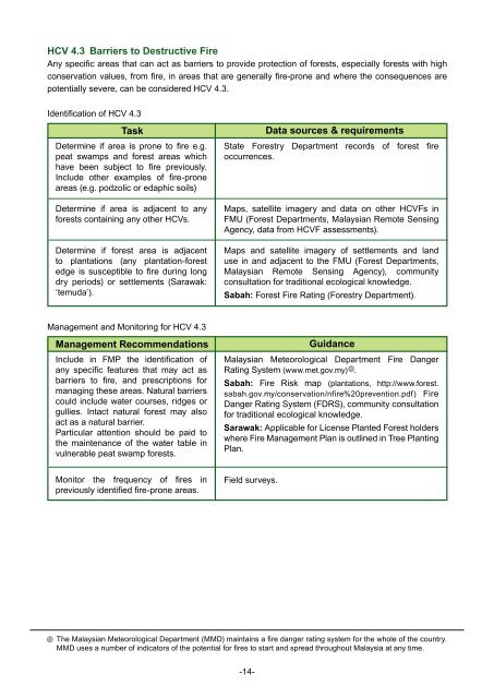
<strong>HCV</strong> 4.3 Barriers to Destructive Fire<br />
Any specific areas that can act as barriers to provide protection of <strong>for</strong>ests, especially <strong>for</strong>ests with high<br />
conservation values, from fire, in areas that are generally fire-prone and where the consequences are<br />
potentially severe, can be considered <strong>HCV</strong> 4.3.<br />
Identification of <strong>HCV</strong> 4.3<br />
Task<br />
Determine if area is prone to fire e.g.<br />
peat swamps and <strong>for</strong>est areas which<br />
have been subject to fire previously.<br />
Include other examples of fire-prone<br />
areas (e.g. podzolic or edaphic soils)<br />
Determine if area is adjacent to any<br />
<strong>for</strong>ests containing any other <strong>HCV</strong>s.<br />
Determine if <strong>for</strong>est area is adjacent<br />
to plantations (any plantation-<strong>for</strong>est<br />
edge is susceptible to fire during long<br />
dry periods) or settlements (Sarawak:<br />
‘temuda’).<br />
Data sources & requirements<br />
State Forestry Department records of <strong>for</strong>est fire<br />
occurrences.<br />
Maps, satellite imagery and data on other <strong><strong>HCV</strong>F</strong>s in<br />
FMU (Forest Departments, <strong>Malaysia</strong>n Remote Sensing<br />
Agency, data from <strong><strong>HCV</strong>F</strong> assessments).<br />
Maps and satellite imagery of settlements and land<br />
use in and adjacent to the FMU (Forest Departments,<br />
<strong>Malaysia</strong>n Remote Sensing Agency), community<br />
consultation <strong>for</strong> traditional ecological knowledge.<br />
Sabah: Forest Fire Rating (Forestry Department).<br />
Management and Monitoring <strong>for</strong> <strong>HCV</strong> 4.3<br />
Management Recommendations<br />
Include in FMP the identification of<br />
any specific features that may act as<br />
barriers to fire, and prescriptions <strong>for</strong><br />
managing these areas. Natural barriers<br />
could include water courses, ridges or<br />
gullies. Intact natural <strong>for</strong>est may also<br />
act as a natural barrier.<br />
Particular attention should be paid to<br />
the maintenance of the water table in<br />
vulnerable peat swamp <strong>for</strong>ests.<br />
Guidance<br />
<strong>Malaysia</strong>n Meteorological Department Fire Danger<br />
Rating System (www.met.gov.my)<br />
10.<br />
Sabah: Fire Risk map (plantations, http://www.<strong>for</strong>est.<br />
sabah.gov.my/conservation/nfire%20prevention.pdf) Fire<br />
Danger Rating System (FDRS), community consultation<br />
<strong>for</strong> traditional ecological knowledge.<br />
Sarawak: Applicable <strong>for</strong> License Planted Forest holders<br />
where Fire Management Plan is outlined in Tree Planting<br />
Plan.<br />
Monitor the frequency of fires in<br />
previously identified fire-prone areas.<br />
Field surveys.<br />
10<br />
The <strong>Malaysia</strong>n Meteorological Department (MMD) maintains a fire danger rating system <strong>for</strong> the whole of the country.<br />
MMD uses a number of indicators of the potential <strong>for</strong> fires to start and spread throughout <strong>Malaysia</strong> at any time.<br />
-14-


