
You also want an ePaper? Increase the reach of your titles
YUMPU automatically turns print PDFs into web optimized ePapers that Google loves.
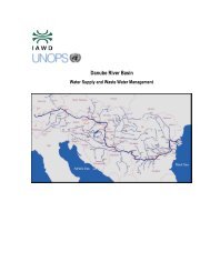
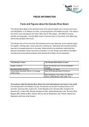
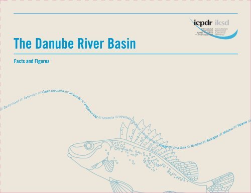
The Danube River Basin<br />
<strong>Facts</strong> and <strong>Figures</strong><br />
//// Deutschland //// Österreich / / Cˇeská republika //// Slovensko //// Magyarország //// Slovenija //// Hrvatska //// Bosna i Hercegovina //// Србија //// Crna Gora //// România //// Å˙΄‡appleËfl //// Moldova //// ìÍapple‡ªÌ‡ ////
The Danube River Basin: an overview page 3<br />
Relying on the Danube: sustenance, energy and livelihoods page 16<br />
Danube environment under threat page 22<br />
Floods and flood protection page 18<br />
map
The <strong>ICPDR</strong>:<br />
Protecting the Danube River Basin page 20<br />
Environmental diversity page 10<br />
Tributaries and lakes page 7<br />
Demographic data page 15<br />
Addressing the threats page 24<br />
Socio-economic diversity page 13
Vrbas<br />
Danube River Basin District<br />
Main-Donau<br />
Kanal<br />
Naab<br />
Did you know?<br />
The Danube River Basin covers<br />
approx. 10 % of Continental Europe.<br />
Laborec<br />
Svratka<br />
Morava<br />
Váh<br />
Donau<br />
Lech<br />
Inn<br />
Isar<br />
Inn<br />
Salzach<br />
Drau<br />
Adriatic<br />
Sea<br />
Traun<br />
Mur<br />
Enns<br />
Ljubljana<br />
Kolpa<br />
Donau<br />
Sava<br />
Dyje<br />
Thaya<br />
Raab<br />
Kupa<br />
Vienna<br />
Rabnitz<br />
Zagreb<br />
Una<br />
Una<br />
Sana<br />
March<br />
Répce<br />
Zala<br />
Mura<br />
Drava<br />
Rába<br />
Bratislava<br />
Rábca<br />
Sava<br />
Dunaj<br />
Bosna<br />
Nitra<br />
Duna<br />
Sió<br />
Sarajevo<br />
Hron<br />
Budapest<br />
Ipel'<br />
Ipoly<br />
Zagyva<br />
Kanal Dunav-<br />
Tisa-Dunav<br />
Drina<br />
Dunav<br />
Slaná<br />
Tisa<br />
Sajó<br />
Tisza-tó<br />
Hármas<br />
Körös<br />
Maros<br />
Hornád<br />
Plovni Begej<br />
Tamiš<br />
Hernád<br />
Hortobágy-Berettyó<br />
Berettyó<br />
Sebes-Körös<br />
Kettos-Körös<br />
Sava<br />
Beograd<br />
Bodrog<br />
Velika Morava<br />
Tisza<br />
Szamos<br />
Latorica<br />
Barcau<br />
Crisul Repede<br />
Crisul Negru<br />
Crisul Alb<br />
Bega<br />
Timis<br />
Timok<br />
Tysa<br />
Somes<br />
Tisa<br />
Somesul Mic<br />
Mures<br />
Jiu<br />
Somesul Mare<br />
Tarnava<br />
Olt<br />
Prut<br />
Mures<br />
Vedea<br />
Siret<br />
Bistrita<br />
Arges<br />
Moldova<br />
Olt<br />
Trotus<br />
Jijia<br />
Ialomita<br />
Bucuresti<br />
Siret<br />
Bârlad<br />
Buzau<br />
Dunarea<br />
Prut<br />
Chisinau<br />
Kagul<br />
Ialpug<br />
Canal Dunarea-<br />
Marea Neagra<br />
Kugurlui<br />
Black<br />
Sea<br />
Neusiedlersee<br />
Lake Balaton<br />
Drina<br />
Lim<br />
Zapadna Morava<br />
Ibar<br />
Južna Morava<br />
Nišava<br />
Ogosta<br />
Nishava<br />
Iskar<br />
Sofia<br />
Dunav<br />
Yantra<br />
Lacul Sinoe<br />
Zmeica and Golovita Lake<br />
Lacul Razim<br />
Ozaro Lalpug
Contracting Parties<br />
of the <strong>ICPDR</strong><br />
European Union<br />
European Commission, DG Environment<br />
www.ec.europa.eu/environment/<br />
Germany<br />
Federal Ministry for the Environment,<br />
Nature Conservation and Nuclear Safety<br />
www.bmu.de/<br />
Responsible Federal States:<br />
www.stmug.bayern.de<br />
www.um.baden-wuerttemberg.de<br />
Austria<br />
Federal Ministry of Agriculture, Forestry,<br />
Environment and Water Management<br />
www.lebensministerium.at/<br />
Slovenia<br />
Ministry of the Environment and Spatial Planning<br />
www.mop.gov.si/<br />
Czech Republic<br />
Ministry of the Environment<br />
www.env.cz/<br />
Croatia<br />
Ministry of Regional Development,<br />
Forestry and Water Management<br />
www.mrrsvg.hr/<br />
Bosnia and Herzegovina<br />
Ministry of Foreign Trade and Economic Relations<br />
www.mvteo.gov.ba/<br />
Republic of Serbia<br />
Ministry of Agriculture, Trade, Forestry<br />
and Water Management<br />
www.minpolj.gov.rs/<br />
Montenegro<br />
Ministry of Agriculture, Forestry<br />
and Water Management<br />
www.minpolj.gov.me/<br />
Slovakia<br />
Ministry of the Environment<br />
www.enviro.gov.sk/<br />
Moldova<br />
Ministry of Environment<br />
and Natural Resources<br />
www.mediu.gov.md/<br />
Bulgaria<br />
Ministry of Environment and Water<br />
www.moew.government.bg/<br />
Romania<br />
Ministry of Enivironment and Forests<br />
www.mmediu.ro/<br />
Ukraine<br />
Ministry for Environmental Protection (MEP)<br />
www.menr.gov.ua/<br />
Hungary<br />
Ministry of Rural Development<br />
www.vm.gov.hu/
The Danube River Basin: an overview<br />
The Danube River Basin is Europe’s second largest river basin, with a total area of<br />
801,463 km². More than 80 million people from 19 countries share the Danube<br />
catchment area, making it the world’s most international river basin. All countries<br />
comprising over 2,000 km² of the Basin, and also the European Union,<br />
are contracting parties of the International Commission for the Protection of the<br />
Danube River (<strong>ICPDR</strong>), which is charged with coordinating the con servation,<br />
improvement and rational use of Danube waters.<br />
Based on its gradients, the Danube River Basin can be divided into three sub-regions:<br />
the Upper, Middle and Lower Basins (the latter including the Danube Delta). The Upper<br />
Basin extends from the source of the Danube in Germany to Bratislava in Slovakia.<br />
The Middle Basin is the largest of the three sub-regions, extending from Bratislava to<br />
the dams of the Iron Gate Gorge on the border between Serbia and Romania. The low -<br />
lands, plateaus and mountains of Romania and Bulgaria form the Lower Basin of the<br />
River Danube. Before reaching the Black Sea, the river divides into three main branches,<br />
forming the Danube Delta, which covers an area of about 6,750 km².<br />
3
Territory in the Danube River Basin (DRB) [km 2 ]<br />
Czech Republic<br />
21,688<br />
Germany<br />
56,184<br />
Austria<br />
80,423<br />
Slovakia<br />
47,084<br />
Ukraine<br />
30,520<br />
Moldova<br />
12,834<br />
Hungary<br />
93,030<br />
Slovenia<br />
16,422<br />
Croatia<br />
34,965<br />
Romania<br />
232,193<br />
Bosnia and<br />
Herzegovina<br />
36,636<br />
Serbia<br />
81,560<br />
Bulgaria<br />
47,413<br />
4<br />
Montenegro<br />
7,075
Did you know?<br />
The Danube is 2,857 km long and up to 1.5 km wide.<br />
It is the second largest river in Europe – after the Volga (3,535 km).<br />
Share of Danube River Basin in %<br />
Slovenia 2,0%<br />
Slovac Republic 5,9%<br />
Serbia 10,2%<br />
Ukraine 5,4%<br />
Austria 10%<br />
Bosnia and Herzegovina 4,6%<br />
Bulgaria 5,9%<br />
Croatia 4,4%<br />
Topographic data for the Danube Basin countries<br />
Percentage of Population in the<br />
Country territory within the DRB [%] DRB [in millions]<br />
Austria 96.1 7.7<br />
Bosnia and Herzegovina 74.9 2.9<br />
Bulgaria 43.0 3.5<br />
Croatia 62.5 3.1<br />
Czech Republic 27.5 2.8<br />
Germany 16.8 9.4<br />
Hungary 100.0 10.0<br />
Moldova 35.6 1.1<br />
Montenegro 51.2 0.2<br />
Romania 97.4 21.7<br />
Serbia 92.3 7.5<br />
Slovak Republic 96.0 5.2<br />
Slovenia 81.0 1.7<br />
Ukraine 5.4 2.7<br />
Czech Republic 2,9%<br />
Romania 29,0%<br />
Germany 7,0%<br />
Hungary 11,6%<br />
Switzerland 0,2%<br />
others < 0,1%<br />
Moldova 1,6%<br />
Montenegro 0,9%<br />
5
Tributaries and lakes<br />
Confluence with Danube in river kilometre<br />
Naab<br />
2,385 rkm<br />
Inn<br />
2,225 rkm<br />
The Danube connects with 27 large and over 300 small tributaries on its way<br />
from the Black Forest to the Black Sea. There are also a large number of lakes in<br />
the Danube Basin.<br />
The main tributaries of the Danube<br />
The Tisza is the longest tributary of the Danube and the largest by catchment area.<br />
Lech<br />
2,497 rkm<br />
Isar<br />
2,282 rkm<br />
Traun<br />
2,125 rkm<br />
At 966 km in length, it is the second largest by flow after the Sava River.<br />
It drains an area of 157,186 km² in five countries (Slovakia, Ukraine, Hungary,<br />
Enns<br />
2,112 rkm<br />
Romania and Serbia). The second longest river is the Prut (950 km), which is also the<br />
last major tributary of the Danube, with its confluence located just upstream of the<br />
Danube Delta. Further downstream, the Prut forms the border between Romania<br />
and Moldova. The second largest river by catchment area, the Sava is 861 km in length<br />
and has the largest discharge of water to the Danube of any tributary. The Inn is the<br />
third largest of the Danube’s tributaries by discharge, and the seventh longest.<br />
Finally, the fourth largest and fourth longest Danube tributary is the Drava.<br />
Like many of the Danube rivers, the Drava has been considerably regulated with<br />
dams constructed to generate hydroelectricity and channels dredged to direct its flow.<br />
Nevertheless, natural habitats along the middle and lower reaches host unique<br />
assemblages of flora and fauna, as well as several endemic species.<br />
6
Did you know?<br />
A large floodplain area lies at the confluence of the Drava and the Danube rivers,<br />
including territories of Hungary, Croatia and Serbia. They provide favourable living conditions<br />
for over 20,000 birds and 55 different species of fish can be found in this area.<br />
Ipel / Ipoly<br />
1,708 rkm<br />
Morava / March<br />
1,880 rkm<br />
Hron<br />
1,716 rkm<br />
Vah<br />
1,766 rkm<br />
Prut<br />
132 rkm<br />
Sió<br />
1,498 rkm<br />
Drau / Drava<br />
1,382 rkm<br />
Tysa / Tisza / Tisa<br />
1,214 rkm<br />
Tamis / Timis<br />
1,154 rkm<br />
Siret<br />
155 rkm<br />
Ialomita<br />
244 rkm<br />
Arges<br />
432 rkm<br />
Sava<br />
1,170 rkm<br />
Jiu<br />
694 rkm<br />
Olt<br />
604 rkm<br />
Morava<br />
1,103 rkm<br />
Timok<br />
846 rkm<br />
Iskar<br />
636 rkm<br />
Yantra<br />
537 rkm<br />
7
The main lakes and water bodies in the Danube Basin District<br />
Austria Neusiedlersee<br />
Hungary Fertő-tó<br />
Romania Lacul Sinoe<br />
Surface area 315 km² Surface area 162 km²<br />
Average depth 1.10 m Average depth N /A<br />
Maximum depth 1.80 m Maximum depth N /A<br />
Hungary Lake Balaton<br />
Romania Zmeica and Golovita Lake<br />
Surface area 605 km² Surface area 162 km²<br />
Average depth 3.60 m Average depth N / A<br />
Maximum depth 10.60 m Maximum depth N / A<br />
Romania Lacul Razim<br />
Surface area<br />
392 km²<br />
Average depth N /A<br />
Maximum depth N /A<br />
Ukraine Ozero Ialpuh<br />
Surface area<br />
149 km²<br />
Average depth N /A<br />
Maximum depth N /A<br />
8
Did you know?<br />
Often affectionately called the “Hungarian Sea” in landlocked Hungary,<br />
Lake Balaton is the largest lake in Central Europe. The Hungarian word “Balaton” derives<br />
from Slavic word “blato”, which means “mud” or “swamp”<br />
Main Danube tributaries<br />
Enters the Length Size of catchment Average, discharge<br />
River Danube at in km in km² in m³ / s<br />
Danube - 2857 801,463 6,460<br />
Lech Marxheim (near Donauwörth), Germany 254 4,125 115<br />
Naab Regensburg, Germany 191 5,530 49<br />
Isar Near Deggendorf, Germany 283 8,964 174<br />
Inn Passau, Germany 515 26,130 738<br />
Traun Near Linz, Austria 153 4,257 132<br />
Enns Mauthausen, Austria 254 6,185 203<br />
Morava/March Devín, Slovakia 329 26,658 106<br />
Raab/Rába Györ, Hungary 311 10,113 88<br />
Vah Komárno, Slovakia 398 18,296 161<br />
Hron Near Štúrovo, Slovakia 278 5,463 55<br />
Ipel/Ipoly Near Szob, Hungary 197 5,108 22<br />
Sió Near Szekszárd, Hungary 121 9,216 39<br />
Drau/Drava Near Osijek, Croatia 893 41,238 577<br />
Tysa/Tisza/Tisa Near Titel, Serbia 966 157,186 794<br />
Sava Belgrade, Serbia 861 95,719 1,564<br />
Tamis/Timis Near Pan˘cevo, Serbia 359 10,147 47<br />
Morava (RS) Near Smederevo, Serbia 430 37,444 232<br />
Timok Bulgarian-Serbian border 180 4,630 31<br />
Jiu Near Gighera, Romania 339 10,080 86<br />
Iskar Gigen, Pleven Province, Bulgaria 368 8,684 54<br />
Olt Turnu Mugurele, Romania 615 24,050 174<br />
Yantra Svishtov, Bulgaria 285 7,879 47<br />
Arges Oltenit˛a, Romania 350 12,550 71<br />
Ialomita Near Hârt ˛sova, Romania 417 10,350 45<br />
Siret Galat˛i, Romania 559 47,610 240<br />
Prut Near Reni, Ukraine 950 27,540 110<br />
9
Environmental diversity<br />
Due to its large area and very diverse habitats – gravel islands on the Upper River,<br />
significant areas of forest floodplain, extended wetlands on the Lower River –<br />
the Danube River provides the right living conditions in areas of high landscape- and<br />
biodiversity for a large number of different species. Along its course there are some<br />
230 of the Danube River Basin’s 2,860 Natura 2000 sites, an ecological network of<br />
internationally important protected areas in the territory of the European Union.<br />
Over 2,000 plant species and 5,000 animal species live in or by the waters of the Danube,<br />
a habitat which hosts about 2,000 vascular plants, over 40 mammals, approximately<br />
100 fish species as well as important bird sanctuaries for species such as the Dalmatian<br />
pelican. In addition, among the eight member states participating in the policy to protect<br />
these sanctuaries, Slovenia and Bulgaria have the highest terrestrial rate of Natura 2000<br />
sites coverage in the whole EU. At 6,750 km², the delta of the Danube River is one of<br />
the world’s largest wetlands (and Europe’s largest remaining natural wetland) featuring<br />
rare fauna and flora, as well as 30 different types of ecosystem. Located in the territories<br />
of Romania and Ukraine, it became a UNESCO World Heritage Site in 1991.<br />
10
Did you know?<br />
Six of the 26 known species of sturgeon inhabit the Danube. Known for its caviar, the Beluga can<br />
attain lengths of 5 m, weigh up to 1000 kg and age to 100 years, attaining sexual maturity at<br />
20 years or more. The fish is endangered due to a combination of slow growth, low reproductive<br />
rates, over fishing and impediments to migration to their spawning grounds.<br />
11
Development indicators for Danube Basin Countries<br />
GDP Total GDP per capita<br />
Country in billions of USD population PPP USD<br />
Austria 366.259 8,356,707 39,454<br />
Bosnia and Herzegovina 29.804 4,613,414 7,634<br />
Bulgaria 90.869 7,576,751 12,067<br />
Croatia 78.427 4,489,409 17,707<br />
Czech Republic 258.959 10,674,947 24,832<br />
Germany 2,806.266 81,757,600 34,212<br />
Hungary 185.873 10,005,000 12,926<br />
Republic of Moldova 10.141 3,567,500 2,842<br />
Montenegro 6.439 672,180 10,286<br />
Romania 258.892 21,959,278 12,131<br />
Serbia 43.662 7,306,677 5,898<br />
Slovakia 115.098 5,429,763 16,281<br />
Slovenia 56.755 2,054,199 28,118<br />
Ukraine 302.454 45,888,000 6,650<br />
European Union 14,793.000 501,064,211 29,729<br />
12
Socio-economic diversity<br />
The Danube countries all depend on the Danube waters as an economic resource. Despite<br />
this uniting feature, the Danube Rivers flow through countries with very different<br />
social and economic conditions. For over forty years, Europe was divided into two political<br />
systems by the Iron Curtain. Following the collapse of the Soviet Union, the countries<br />
of Eastern Europe faced political and economic upheaval, with emerging free-market democracies<br />
and the associated impacts of globalisation, privatisation and deregulation.<br />
Simultaneously, industrial and agricultural output collapsed, leading to high unemployment.<br />
More recently, several Eastern European countries have made huge progress, successfully<br />
adapting production to international standards and acceding to the European Union.<br />
The socio-economic data presented in the table left shows how diverse the region is.<br />
There is a wide gulf between the GDP per capita of Austria, Germany and Slovenia and the<br />
other Danube Basin countries: the wealthiest country’s GDP per capita is nearly 14 times<br />
higher than that of the poorest.<br />
In terms of the characteristics of water use, data shows great differences in the<br />
Danube countries. They correspond mainly to the relative im portance of the agricultural<br />
sector. While 9.8% of Ukrainian, 12.4% of Romanian and 21.8% of Moldovan GDP is<br />
generated from agriculture, this share is only 1.7% for Austria, 2.4% for Germany and<br />
2.6% for Czech Republic.<br />
13
Demographic data<br />
Demographic data for<br />
Danube Basin countries<br />
17.33<br />
229<br />
20.3<br />
14.6<br />
71.2<br />
15.8<br />
Population density / km²<br />
67.23<br />
18<br />
66.1<br />
69.3<br />
Age structure<br />
Years 65 + [%]<br />
15 – 64 [%]<br />
112<br />
100<br />
67.5<br />
133<br />
111<br />
12.5<br />
71.7<br />
108<br />
102<br />
0 – 14 [%]<br />
15.44<br />
14.5<br />
13.7<br />
14.2<br />
15.8<br />
15<br />
16.5<br />
69.9<br />
13.5<br />
Country<br />
Population<br />
Urban population [%]<br />
Population growth rate [%]<br />
European Austria Germany Czech Slovakia Hungary Slovenia<br />
Union<br />
Republic<br />
501,064,211 8,356,707 81,757,600 10,674,947 5,429,763 10,005,000 2,054,199<br />
NA 67 68 74 56 68 48<br />
0.098 0.098 -0.061 -0.106 0.129 -0.156 -0.142<br />
14
The population of Europe as a percentage of the world population is rapidly decreasing<br />
and is expected to decline over the next forty years. Populations in the Danube River<br />
Basin are no exception. Most of the Danube Basin countries have begun to experience<br />
negative population growth rates, with only three countries – Austria, Bosnia and<br />
Herzegovina and Slovakia – displaying marginal population growth. As populations<br />
in the Danube Basin shrink and age, this will result in changing social and consumption<br />
patterns that may, in turn, lead to a change in environmental impacts.<br />
14.7<br />
15.9<br />
69.7<br />
70.3<br />
16.8<br />
17.7<br />
67.8<br />
68.5<br />
79<br />
16.9<br />
67.8<br />
74<br />
14.4<br />
70.1<br />
101<br />
90<br />
68<br />
105<br />
10.8<br />
78<br />
45<br />
73.3<br />
15.5<br />
13.8<br />
15.3<br />
15.5<br />
13.7<br />
70.3<br />
16<br />
15.4<br />
13.8<br />
15.9<br />
Croatia Bosnia and Montenegro Republic Romania Bulgaria Republic Ukraine<br />
Herzegovina of Serbia of Moldova<br />
4,489,409 4,613,414 672,180 7,306,677 21,959,278 7,576,751 3,567,500 45,888,000<br />
57 47 60 52 54 71 42 68<br />
-0.061 0.016 -0.777 -0.469 -0.247 -0.768 -0.072 -0.619<br />
15
Relying on the Danube:<br />
sustenance, energy and livelihoods<br />
The economic value of the Danube River is immense; it is a vital resource for water supply,<br />
sustaining biodiversity, agriculture, industry, fishing, recreation, tourism, power generation<br />
and navigation. A large number of dams, reservoirs, dykes, navigation locks and other<br />
hydraulic structures have been built in the Basin to facilitate many of these important<br />
water uses.<br />
Historically, the Danube and some of its main tributaries, such as the Sava, have formed<br />
important trade routes across Europe for centuries. Historically, the channelization<br />
of the river’s course has made it easier for ships to navigate 2,411 km, or 87%, of the length<br />
of the Danube. As “Corridor VII” of the European Union, the Danube connects the<br />
Black Sea with the industrial centres of Western Europe and with the Port of Rotterdam.<br />
Recent years saw an increasing awareness for the need to balance economic and environmental<br />
need in navigation management with special attention to the natural characteristics<br />
of the river. This was reflected in the “Joint Statement on Inland Navigation”, issued by<br />
the <strong>ICPDR</strong>, Danube Commission and Sava Commission. A similar consultation process is<br />
maintained between the <strong>ICPDR</strong> and representatives from the hydropower sector.<br />
16
Did you know?<br />
Hydropower accounts for 30% of national generation capacity in Romania,<br />
which has more than 400 large dams. Around 60% of the annual electricity generation<br />
within the Danube River Basin in Austria originates from hydropower.<br />
Did you know?<br />
A single inland navigation vessel can carry the same volume of goods<br />
as 93 railway wagons or 173 trucks.<br />
Did you know?<br />
Owing to its considerable natural gradient,<br />
a total of 59 dams have been built in the upper part of the Danube.<br />
This means that the Upper Danube is interrupted every 16 km on average.<br />
There are over 700 dams and weirs along the main tributaries of the Danube.<br />
As such, very few stretches can still be characterised as free-flowing.<br />
17
Floods and flood protection<br />
Flooding is the most common natural disaster in Europe and, in terms of economic<br />
damage, the most costly one. There have been 78 significant floods along the Danube<br />
over the last nine centuries; 23 of them took place in the 18th century before extensive<br />
flood protection works were started. Since then significant areas of natural flood -<br />
plains have been lost through drainage for agriculture, city development and flood<br />
protection dykes – 80% in total.<br />
Recent years saw a steepening in the curve of flood frequency, and high-water marks<br />
have set records three times since 2002. Five of the most significant floods have occurred<br />
in the last 10 years. Neglected levies contributed to this damage, along with long<br />
winters and unusually heavy snow and rain. Multi-annual averages for precipitation have<br />
been exceeded by 1.5 to 2.0 times recently, a maximum never before observed since systematic<br />
instrumental weather observations have been available.<br />
1838 March<br />
Icy flood in Budapest.<br />
Damage: 10.100 houses,<br />
153 lives lost.<br />
1888 spring<br />
The increasing regularity of dangerous hydro-meteorological phenomena is<br />
a cause for concern. Estimation scenarios by the European Environmental Agency<br />
predict that flood damage and the number of people affected by flooding<br />
will rise substantially by 2100 as a result of climate change, with one scenario<br />
estimating a rise in flood damage of some 40% and an increase in the<br />
number of people affected of around 242,000 (about 11%). The EU formalized<br />
flood management in 2007 through the Flood Directive. The <strong>ICPDR</strong> coordinates<br />
its implementation in the Danube Basin.<br />
Extreme floods in Tisza valley.<br />
Damage: Successful protection<br />
from dykes.<br />
1890<br />
Major floods<br />
in the Upper<br />
Danube.<br />
1919 spring<br />
Extreme floods in Tisza valley.<br />
Damage: Successful protection from dykes.<br />
1925 Christmas<br />
Flood in the Krös valley, two dykes burst.<br />
21,000 ha flooded, 904 houses destroyed.<br />
18
1954<br />
Major floods in the Upper Danube.<br />
Measures to manage floods<br />
1. Improving flood forecasts and early flood warning systems.<br />
2. Supporting coordinated sub-basin-wide flood action plans.<br />
3. Creating forums for exchange of expert knowledge.<br />
4. Promoting a common approach to assess flood-prone areas and evaluate flood risk.<br />
1965 April-July<br />
The biggest ever summer flood of the Danube at that time. Due to significant protection efforts a disaster was prevented.<br />
11 dykes burst in the Rába valley.<br />
1970 May-July<br />
The largest ever Tisza valley flooding at that time.<br />
In other areas, the catastrophe was prevented by protection efforts.<br />
14 dykes burst in the Romanian section of the Szamos and 3 in the Hungary;<br />
57,000 ha flooded, 5,400 buildings destroyed; 9,000 inhabitants were relocated<br />
for safety reasons.<br />
1992<br />
Tazlau Romania.<br />
107 lives lost.<br />
1998-2001<br />
Extreme floods in four subsequent years at the Tisza.<br />
2010<br />
Floods at Tisza<br />
and Danube<br />
simultaneously.<br />
2009<br />
1997<br />
Flooding on the Oder (Poland, Germany) and Morava/Danube (Czech Republic, Germany).<br />
105 lives lost.<br />
2002<br />
2005<br />
Record flood levels for the Danube and the Elbe.<br />
Record flood levels for the Danube.<br />
2006<br />
Romania: 31 lives lost, 55roads closed, 600 bridges washed away.<br />
Bulgaria & Moldova: 14,000 people evacuated.<br />
Record flood levels for the Danube.<br />
Bulgaria: 482 buildings destroyed,<br />
300 people evacuated, 6,000 lives endangered.<br />
Romania: 300 buildings destroyed,<br />
16,000 people evacuated, 150 villages flooded.<br />
Serbia: several thousands evacuated due to a lack of clean water.<br />
Record rain and flood levels for the Danube.<br />
Hungary: 198,000 ha affected.<br />
Romania: 110,000 ha of agricultural land were inundated by water.<br />
19
The <strong>ICPDR</strong>:<br />
Protecting the Danube River Basin<br />
The Danube countries came together to sign the Danube River Protection Convention<br />
(DRPC) in 1994 and established the International Commission for the Protection<br />
of the Danube River (<strong>ICPDR</strong>) in 1998 to fulfil the Convention’s objectives. The <strong>ICPDR</strong><br />
is made up of 15 contracting parties (Austria, Bosnia and Herzegovina, Bulgaria,<br />
Croatia, the Czech Republic, Germany, Hungary, Moldova, Montenegro, Romania,<br />
Serbia, Slovakia, Slovenia, Ukraine and the European Union) committed to implementing<br />
the DRPC; it is a forum for coordination and cooperation on important water management<br />
issues.<br />
The <strong>ICPDR</strong> comprises primarily of national delegations that meet twice a year. With<br />
a secretariat based in Vienna, it is chaired by a president who serves for one year,<br />
and the presidency is passed on from one member country to another in alphabetical<br />
order. Much of the work of the <strong>ICPDR</strong> is done by Expert Groups, panels of<br />
specialists from the <strong>ICPDR</strong> member countries and 21 official observers.<br />
The <strong>ICPDR</strong> is also the facilitating platform for implementation of the EU Water<br />
Framework Directive (WFD) and the EU Flood Directive (EFD). Although not all<br />
members of the EU, contracting parties to the <strong>ICPDR</strong> have committed to meeting the<br />
goals of the WFD, which requires “good status” or “good potential” of all surface<br />
and ground waters by 2015.<br />
Objectives of the Danube River Protection Convention<br />
Ensure sustainable and equitable water management<br />
Control floods and ice hazard<br />
20
Control the discharge of wastewaters, inputs of nutrients and hazardous substances from point and non-point sources<br />
Conserve, improve and promote the rational use of surface waters and ground water<br />
Did you know?<br />
The 29th of June each year is Danube Day, an excellent and light-hearted way to engage the Danube<br />
River Basin’s more than 80 million inhabitants in celebrating their rivers and participating in the<br />
development of a sustainable future for the region. Find out more at: www.danubeday.org.<br />
Reduce pollution loads to the Black Sea from sources in the Danube catchment<br />
Control hazards originating from accidents (warning and preventive measures)
Danube environment under threat<br />
22<br />
22% (5,494 km) of the length of tributaries<br />
are of good ecological status / potential.<br />
Human activity has affected the Danube and its network of tributaries negatively in<br />
manifold ways. Industry, agriculture and tourism are all economically important and<br />
depend on the Danube as a resource, yet at the same time they also threaten the Danube<br />
as a biodiversity hotspot. The following subsections provide an overview of some of the<br />
most significant threats to the Danube environment.<br />
Water pollution<br />
The list of industrial pollutants added by countries as the Danube flows south and east is<br />
long: fertilisers, farm pesticides and manure, as well as discharge from smelters,<br />
paper mills, chemical plants and tanneries. Human activities in the Danube River Basin<br />
are responsible for the high levels of nutrients (nitrogen and phosphorus) discharged into<br />
the water. The main sources of nutrients in the Danube are agriculture (50%), municipal<br />
waste water (25%) and industry (25%). The total nitrogen load in the Danube is between<br />
537,000 and 551,000 tonnes per year and the total phosphorus load is 48,900 tonnes per<br />
year. The legal limit for nutrient content in groundwater is often exceeded throughout<br />
the whole basin, though at least decreasing in recent years. The river is further polluted<br />
by hazar dous substances, such as heavy metals, oil and microbiological pollution.<br />
Increased shipping along the Danube would most likely increase overall pollution,<br />
as will future crises and disasters.<br />
22<br />
Crises and disasters<br />
A number of crises and disasters have affected the Danube River Basin in recent years.<br />
Some of them have gained worldwide media attention, such as the Baia Mare cyanide<br />
spill in 2000 or the Ajka red sludge spill in 2010. At this recent event, a dam broke at a<br />
Hungarian aluminium plant, releasing some 700,000 m 3 of red sludge. 10 people died<br />
and about 1100 hectares of land were affected. The <strong>ICPDR</strong> has set up the Accident<br />
Emergency Warning System (AEWS) of the Danube River Basin, which is activated<br />
whenever there is a risk of transboundary water pollution. The AEWS sends out<br />
international warning messages to countries downstream to help the authorities put<br />
environmental protection and public safety measures into action.<br />
Loss of wetlands and floodplains<br />
Man-made changes to the natural course of the Danube waterways have interrupted river<br />
and habitat continuity and have disconnected wetlands and changed water quantity<br />
and flow conditions. Draining wetlands for agriculture often provides only marginal<br />
farmland while destroying unique wetland habitat while introducing foreign varieties of<br />
trees to floodplain forests and clear cutting in the name of industry eliminates undergrowth<br />
and alters the function of the floodplain ecosystem. Building towns and villages<br />
in floodplain areas also leaves them prone to damage from flooding. Species in the<br />
Danube River Basin are also threatened: migratory fish such as the Beluga have lost<br />
access to their spawning grounds due to dams and levies, threatening their existence<br />
in the Danube region.
The ecological and chemical status of Danube Basin Water Bodies<br />
56<br />
56% of the Danube River have been<br />
designated as heavily modified.<br />
Good ecological status cannot be<br />
achieved in these stretches due to<br />
physical alterations.<br />
27 3<br />
27% of the river network do not achieve<br />
good chemical status.<br />
3<br />
3 of the 6 major lakes in the<br />
Danube River Basin do not achieve<br />
good ecological status.<br />
39<br />
39% of the Danube and its tributaries<br />
have been designated as heavily<br />
modified. Good ecological status<br />
cannot be achieved in these stretches.<br />
3 of 11 transboundary groundwater<br />
bodies are experiencing significant nitrate<br />
pollution; 8 were found to be of good<br />
chemical status.<br />
23
Addressing the threats<br />
The <strong>ICPDR</strong> is an international organisation that acts as a platform to coordinate<br />
responses to various environmental threats. Since 2009, the Danube River Management<br />
Plan (DRBM) provides a roadmap for this. It contains a Joint Programme of Measures<br />
and aims to fulfil the EU Water Framework Directive (WFD). The <strong>ICPDR</strong> also implements<br />
the EU Flood Directive (EFD) and plays a key-role in the EU Danube Strategy.<br />
Pollution Reduction<br />
The contracting parties of the <strong>ICPDR</strong> have developed best agricultural and industrial<br />
practices. These include the appropriate use of agrochemicals, proper storage of manure,<br />
or effective irrigation. Wastewaters from households are subject to important measures:<br />
wastewater treatment plants are modernised and for years, the <strong>ICPDR</strong> has worked<br />
towards limiting phosphates in detergents. This was recently taken into consideration for<br />
EU legislation. Ongoing assessments of water quality are done through the TNMN<br />
(Transnational Monitoring Network), which is coordinated by the <strong>ICPDR</strong>.<br />
Flood Protection<br />
In response to the danger of flooding, the <strong>ICPDR</strong> adopted the Action Programme on<br />
Sustainable Flood Protection in 2004. The goal of this program is to achieve a long-term<br />
and sustainable approach for managing the risks of flooding to protect human life and<br />
property, while encouraging conservation and improvement of water-related ecosystems.<br />
River Restoration<br />
The natural course of the rivers in the Danube River Basin was altered for centuries,<br />
mainly for agriculture, hydropower generation, flood defence, and navigation.<br />
Hydromorphological alterations such as river interruptions, the disconnection of<br />
wetlands, or water abstraction can provoke changes in the natural structure of rivers.<br />
As a response, the <strong>ICPDR</strong> has started initiatives that include the restoration of river<br />
continuity, the establishment of green corridors, and the construction of fish migration<br />
aids. In addition, the <strong>ICPDR</strong> engages in an active dialogue with representatives from the<br />
hydropower, flood protection and navigation sector to work towards the restoration of a<br />
natural river morphology.<br />
Public Participation<br />
Taking views from the public into consideration for water management is vital for<br />
balancing environmental, economic and social needs in the protection of the Danube<br />
River Basin. The WFD requires that countries encourage the active involvement of<br />
interested parties in decision making. Public participation is therefore a key principle<br />
of the <strong>ICPDR</strong>. On a formal level, observers have the right to participate at all <strong>ICPDR</strong><br />
decision-making meetings.<br />
24
Visions of the <strong>ICPDR</strong> Danube<br />
River Basin Management Plan<br />
Hazardous substances:<br />
No risk or threat to human health or<br />
the aquatic ecosystem;<br />
Nutrient pollution:<br />
Balanced management so that neither the waters<br />
of the Danube Basin nor the Black Sea are threatened<br />
or affected by eutrophication;<br />
Organic pollution:<br />
Zero emissions of untreated waste water<br />
into the basin’s rivers;<br />
Groundwater:<br />
Emissions of polluting substances do not cause<br />
any deterioration of groundwater quality.<br />
Water use is appropriately balanced and does not<br />
exceed the available resources.<br />
Hydromorphological alterations:<br />
Balanced management of structural man-made<br />
changes so that the aquatic ecosystem functions<br />
holistically with all native species represented.<br />
Further information:<br />
http://www.icpdr.org/ <br />
http://www.danubeday.org/ <br />
http://www.danubebox.org/ <br />
http://www.icpdr.org/jds/
Contact:<br />
<strong>ICPDR</strong> Secretariat<br />
Vienna International Centre, D0412<br />
PO Box 500, 1400 Vienna, Austria<br />
Phone: +43 (1) 26060-5738, Fax: +43 (1) 26060-5895<br />
Email: icpdr@unvienna.org<br />
Web: www.icpdr.org<br />
Executive Editor: Benedikt Mandl<br />
Text: Oliver Gascoigne, gascoigneor@hotmail.com<br />
Layout: Büro X Wien, www.buerox.at<br />
Coordination: Public Participation EG of the <strong>ICPDR</strong><br />
Photographs: Milorad Drca, Gerfried Koch, János László, Victor Mello, <br />
Mario Romulic, Milan Vogrin and <strong>ICPDR</strong> Photos<br />
The <strong>ICPDR</strong> would like to thank the organisations and photographers for providing<br />
the photographs for free.<br />
Disclaimer:<br />
The information presented in this brochure is largely based on the Danube River Basin<br />
Management Plan (DRBMP) of 2009 and its underlying analysis. All other sources can<br />
be given upon request.<br />
Where data has been made available, it has been dealt with and presented to the<br />
best of our knowledge. Nevertheless, inconsistences cannot be ruled out.<br />
//// Deutschland //// Österreich //// Cˇeská republika //// Slovensko //// Magyarország //// Slovenija //// Hrvatska //// Bosna i Hercegovina //// Србија //// Crna Gora //// România //// Å˙΄‡appleËfl //// Moldova //// ìÍapple‡ªÌ‡ /////